Bridge Statistics for Merrillville, Indiana (IN)
Condition, Traffic, Stress, Structural Evaluation, Project Costs
- National Bridge Inventory (NBI) Statistics
- 39Number of bridges
- 308ft / 94.2mTotal length
- $2,434,000Total costs
- 931,798Total average daily traffic
- 124,944Total average daily truck traffic
- National Bridge Inventory (NBI) Registered Bridges for Merrillville
- No street view available for this location
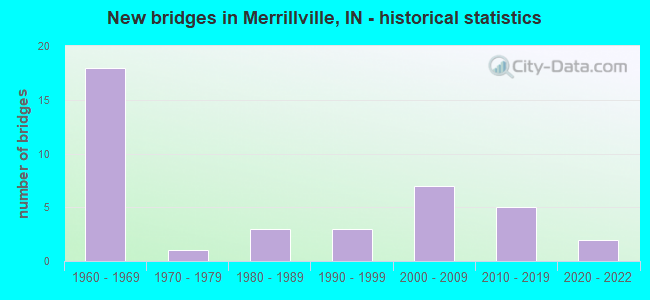
- New bridges - historical statistics
- 181960-1969
- 11970-1979
- 31980-1989
- 31990-1999
- 72000-2009
- 52010-2019
- 22020-2022
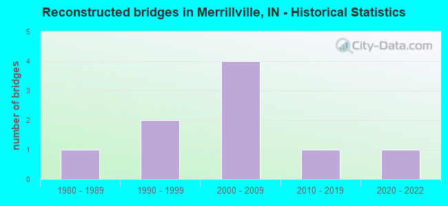
- Reconstructed bridges - Historical Statistics
- 11980-1989
- 21990-1999
- 42000-2009
- 12010-2019
- 12020-2022
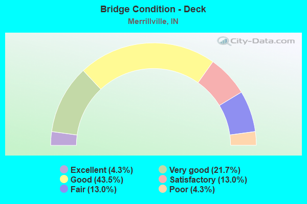
- Bridge Condition - Deck
- 4.3%Excellent
- 21.7%Very good
- 43.5%Good
- 13.0%Satisfactory
- 13.0%Fair
- 4.3%Poor
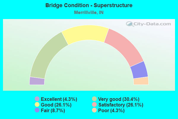
- Bridge Condition - Superstructure
- 4.3%Excellent
- 30.4%Very good
- 26.1%Good
- 26.1%Satisfactory
- 8.7%Fair
- 4.3%Poor
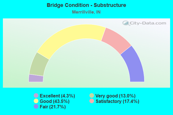
- Bridge Condition - Substructure
- 4.3%Excellent
- 13.0%Very good
- 43.5%Good
- 17.4%Satisfactory
- 21.7%Fair
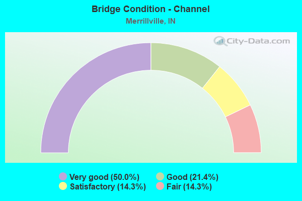
- Bridge Condition - Channel
- 50.0%Very good
- 21.4%Good
- 14.3%Satisfactory
- 14.3%Fair
Find on map >> Show street view
Structure Number: 1948, Location: 02.31 N US 30 (Lat: 41.504481, Lng: -87.336019), Route carried "on" structure: State highway 53, Year Built: 1984, Year Reconstructed: 2015, Status: Open, Structure Length: 3.40m (11.15ft), Average Daily Traffic: 29,702 (year 2004), Truck Traffic: 5%, Average Future Daily Traffic: 48,000 (year 2030), Design Load: HS 20, Features Intersected: TURKEY CREEK
Minimum Vertical Clearance: 30+ m (98+ ft), Kilometerpoint: 11.523, Lanes on structure: 5, Owner: State Highway Agency, Approaching Roadway Width: 24.4m (80.1ft), Material/Design: Steel continuous, Design/Construction: Stringer/Multi-beam, Number Of Spans In Main Unit: 2, Length of Maximum Span: 16.5m (54.1ft), Curb-To-Curb Width: 24.4m (80.1ft), Out-to-Out Width: 25.1m (82.3ft)
Condition: Deck: Good, Superstructure: Good, Substructure: Good, Channel: Good, Operating Rating: 48.9 metric tons, Method Used To Determine Operating Rating: Load and Resistance Factor Rating (LRFR) rating reported by rating factor(RF) method using HL-93 loadings, Inventory Rating: 37.6 metric tons, Method Used To Determine Inventory Rating: Load and Resistance Factor Rating (LRFR) rating reported by rating factor(RF) method using HL-93 loadings, Structural Evaluation: Better than present minimum criteria, Deck Geometry: Superior to present desirable criteria, Waterway Adequacy: Equal to present desirable criteria, Approach Roadway Alignment: Equal to present desirable criteria, Designated Inspection Frequency: Every 24 months, Underwater Inspection Frequency: Every 60 months, Inspection Date: Febuary 2021, Underwater Inspection Date: June 2020, Deck Structure Type: Concrete Cast-file-Place, Wearing Surface/Protective System: Wearing Surface: Latex Concrete, Deck Protection: Epoxy Coated Reinforcing
Find on map >> Show street view
Structure Number: 1988, Location: 01.92 N US 30 (Lat: 41.498750, Lng: -87.365061), Route carried "on" structure: State highway 55, Year Built: 1993, Status: Open, Structure Length: 2.56m (8.40ft), Average Daily Traffic: 19,257 (year 2004), Truck Traffic: 5%, Average Future Daily Traffic: 27,133 (year 2029), Design Load: HS 20, Features Intersected: TURKEY CREEK
Minimum Vertical Clearance: 30+ m (98+ ft), Kilometerpoint: 37.272, Lanes on structure: 2, Owner: State Highway Agency, Approaching Roadway Width: 14.0m (45.9ft), Skew: 1 degrees, Material/Design: Concrete continuous, Design/Construction: Slab, Number Of Spans In Main Unit: 3, Length of Maximum Span: 9.8m (32.2ft), Curb-To-Curb Width: 13.8m (45.3ft), Out-to-Out Width: 14.7m (48.2ft)
Condition: Deck: Satisfactory, Superstructure: Satisfactory, Substructure: Good, Channel: Good, Operating Rating: 68.6 metric tons, Method Used To Determine Operating Rating: Load Factor (LF), Inventory Rating: 42.1 metric tons, Method Used To Determine Inventory Rating: Load Factor (LF), Structural Evaluation: Equal to present minimum criteria, Deck Geometry: Superior to present desirable criteria, Waterway Adequacy: Equal to present minimum criteria, Approach Roadway Alignment: Equal to present desirable criteria, Designated Inspection Frequency: Every 24 months, Inspection Date: September 2021, Deck Structure Type: Concrete Cast-file-Place, Wearing Surface/Protective System: Wearing Surface: Monolithic Concrete, Deck Protection: Epoxy Coated Reinforcing
Find on map >> Show street view
Structure Number: 38531, Location: 02.50 S US 30 (Lat: 41.434969, Lng: -87.321511), Route carried "on" structure: City street , Year Built: 2018, Status: Open, Structure Length: 5.27m (17.29ft), Average Daily Traffic: 4,100 (year 2013), Truck Traffic: 5%, Average Future Daily Traffic: 5,700 (year 2028), Design Load: HL 93, Features Intersected: I-65 NB/SB, Facility Carried by Structure: E 101ST AVE
Minimum Vertical Clearance: 30+ m (98+ ft), Kilometerpoint: 0.000, Lanes on structure: 2, Lanes under structure: 6, Owner: State Highway Agency, Approaching Roadway Width: 14.6m (47.9ft), Material/Design: Prestressed concrete continuous, Design/Construction: Tee Beam, Number Of Spans In Main Unit: 2, Length of Maximum Span: 26.1m (85.6ft), Curb or Sidewalk Widths: Left: 2.0m (6.6ft), Right: 0.0m, Curb-To-Curb Width: 14.6m (47.9ft), Out-to-Out Width: 17.3m (56.8ft)
Condition: Deck: Excellent, Superstructure: Excellent, Substructure: Excellent, Operating Rating: 51.8 metric tons, Method Used To Determine Operating Rating: Load and Resistance Factor Rating (LRFR) rating reported by rating factor(RF) method using HL-93 loadings, Inventory Rating: 39.9 metric tons, Method Used To Determine Inventory Rating: Load and Resistance Factor Rating (LRFR) rating reported by rating factor(RF) method using HL-93 loadings, Structural Evaluation: Superior to present desirable criteria, Deck Geometry: Superior to present desirable criteria, Underclear: Equal to present minimum criteria, Approach Roadway Alignment: Equal to present desirable criteria, Designated Inspection Frequency: Every 24 months, Inspection Date: April 2021, Deck Structure Type: Concrete Cast-file-Place, Wearing Surface/Protective System: Wearing Surface: Monolithic Concrete, Deck Protection: Epoxy Coated Reinforcing
Find on map >> Show street view
Structure Number: 38535, Location: 01.70 S US 30 (Lat: 41.449050, Lng: -87.321533), Route carried "on" structure: City street , Year Built: 2000, Status: Open, Structure Length: 7.23m (23.72ft), Average Daily Traffic: 8,998 (year 2015), Truck Traffic: 1%, Average Future Daily Traffic: 13,370 (year 2035), Design Load: HS 20+Mod, Features Intersected: I-65 NB/SB, Facility Carried by Structure: 93RD AVENUE
Minimum Vertical Clearance: 30+ m (98+ ft), Kilometerpoint: 0.000, Lanes on structure: 4, Lanes under structure: 6, Owner: State Highway Agency, Approaching Roadway Width: 15.6m (51.2ft), Material/Design: Prestressed concrete continuous, Design/Construction: Tee Beam, Number Of Spans In Main Unit: 2, Length of Maximum Span: 35.9m (117.8ft), Curb or Sidewalk Widths: Left: 1.6m (5.2ft), Right: 1.6m (5.2ft), Curb-To-Curb Width: 15.6m (51.2ft), Out-to-Out Width: 19.8m (65.0ft)
Condition: Deck: Good, Superstructure: Satisfactory, Substructure: Good, Operating Rating: 51.0 metric tons, Method Used To Determine Operating Rating: Load Factor (LF), Inventory Rating: 30.6 metric tons, Method Used To Determine Inventory Rating: Load Factor (LF), Structural Evaluation: Equal to present minimum criteria, Deck Geometry: Meets minimum limits, Underclear: Somewhat better than minimum adequacy, Approach Roadway Alignment: Equal to present desirable criteria, Designated Inspection Frequency: Every 24 months, Inspection Date: April 2021, Deck Structure Type: Concrete Cast-file-Place, Wearing Surface/Protective System: Wearing Surface: Epoxy Overlay, Deck Protection: Epoxy Coated Reinforcing
Find on map >> Show street view
Structure Number: 3854, Location: 05.38 N US 231 (Lat: 41.471161, Lng: -87.323897), Route carried "on" structure: Interstate 65, Year Built: 1966, Year Reconstructed: 2002, Status: Open, Structure Length: 7.38m (24.21ft), Average Daily Traffic: 50,976 (year 2004), Truck Traffic: 5%, Average Future Daily Traffic: 101,543 (year 2030), Design Load: HS 20, Features Intersected: US 30 EB/WB, CD, RAMPS
Minimum Vertical Clearance: 30+ m (98+ ft), Kilometerpoint: 405.651, Lanes on structure: 5, Lanes under structure: 11, Base Highway Network: Yes (, Subroute: 1), Owner: State Highway Agency, Approaching Roadway Width: 26.8m (87.9ft), Material/Design: Prestressed concrete continuous, Design/Construction: Tee Beam, Number Of Spans In Main Unit: 4, Length of Maximum Span: 36.9m (121.1ft), Curb-To-Curb Width: 26.2m (86.0ft), Out-to-Out Width: 27.0m (88.6ft)
Condition: Deck: Good, Superstructure: Very good, Substructure: Fair, Operating Rating: 42.1 metric tons, Method Used To Determine Operating Rating: Load and Resistance Factor Rating (LRFR) rating reported by rating factor(RF) method using HL-93 loadings, Inventory Rating: 32.4 metric tons, Method Used To Determine Inventory Rating: Load and Resistance Factor Rating (LRFR) rating reported by rating factor(RF) method using HL-93 loadings, Structural Evaluation: Somewhat better than minimum adequacy, Deck Geometry: Superior to present desirable criteria, Underclear: Equal to present minimum criteria, Approach Roadway Alignment: Equal to present desirable criteria, Designated Inspection Frequency: Every 24 months, Inspection Date: April 2021, Deck Structure Type: Concrete Cast-file-Place, Wearing Surface/Protective System: Wearing Surface: Monolithic Concrete, Deck Protection: Epoxy Coated Reinforcing
Find on map >> Show street view
Structure Number: 3855, Location: 05.38 N US 231 (Lat: 41.471119, Lng: -87.324197), Route carried "on" structure: Interstate 65, Year Built: 1966, Year Reconstructed: 2002, Status: Open, Structure Length: 7.38m (24.21ft), Average Daily Traffic: 50,976 (year 2004), Truck Traffic: 5%, Average Future Daily Traffic: 101,543 (year 2030), Design Load: HS 20, Features Intersected: US 30 EB/WB, 2 CD, RAMPS
Minimum Vertical Clearance: 30+ m (98+ ft), Kilometerpoint: 405.651, Lanes on structure: 4, Lanes under structure: 11, Base Highway Network: Yes (, Subroute: 1), Owner: State Highway Agency, Approaching Roadway Width: 22.6m (74.1ft), Material/Design: Prestressed concrete continuous, Design/Construction: Tee Beam, Number Of Spans In Main Unit: 2, Length of Maximum Span: 36.9m (121.1ft), Curb-To-Curb Width: 22.6m (74.1ft), Out-to-Out Width: 23.4m (76.8ft)
Condition: Deck: Very good, Superstructure: Good, Substructure: Fair, Operating Rating: 39.2 metric tons, Method Used To Determine Operating Rating: Load and Resistance Factor Rating (LRFR) rating reported by rating factor(RF) method using HL-93 loadings, Inventory Rating: 30.1 metric tons, Method Used To Determine Inventory Rating: Load and Resistance Factor Rating (LRFR) rating reported by rating factor(RF) method using HL-93 loadings, Structural Evaluation: Somewhat better than minimum adequacy, Deck Geometry: Superior to present desirable criteria, Underclear: Equal to present minimum criteria, Approach Roadway Alignment: Equal to present desirable criteria, Designated Inspection Frequency: Every 24 months, Inspection Date: April 2021, Deck Structure Type: Concrete Cast-file-Place, Wearing Surface/Protective System: Wearing Surface: Epoxy Overlay, Deck Protection: Epoxy Coated Reinforcing
Find on map >> Show street view
Structure Number: 3858, Location: 00.94 N US 30 (Lat: 41.484719, Lng: -87.321350), Route carried "on" structure: City street , Year Built: 1965, Year Reconstructed: 1992, Status: Open, Structure Length: 6.28m (20.60ft), Average Daily Traffic: 13,255 (year 2004), Truck Traffic: 5%, Average Future Daily Traffic: 18,676 (year 2030), Design Load: HS 20, Features Intersected: I-65, Facility Carried by Structure: 73RD AVENUE
Minimum Vertical Clearance: 30+ m (98+ ft), Kilometerpoint: 0.000, Lanes on structure: 2, Lanes under structure: 4, Owner: State Highway Agency, Approaching Roadway Width: 8.5m (27.9ft), Material/Design: Steel continuous, Design/Construction: Stringer/Multi-beam, Number Of Spans In Main Unit: 4, Length of Maximum Span: 19.9m (65.3ft), Curb or Sidewalk Widths: Left: 1.1m (3.6ft), Right: 1.1m (3.6ft), Curb-To-Curb Width: 9.1m (29.9ft), Out-to-Out Width: 12.3m (40.4ft)
Condition: Deck: Fair, Superstructure: Satisfactory, Substructure: Satisfactory, Operating Rating: 39.2 metric tons, Method Used To Determine Operating Rating: Load and Resistance Factor Rating (LRFR) rating reported by rating factor(RF) method using HL-93 loadings, Inventory Rating: 23.0 metric tons, Method Used To Determine Inventory Rating: Load and Resistance Factor Rating (LRFR) rating reported by rating factor(RF) method using HL-93 loadings, Structural Evaluation: Somewhat better than minimum adequacy, Deck Geometry: Meets minimum limits, Underclear: High priority of corrective action, Approach Roadway Alignment: Equal to present desirable criteria, Designated Inspection Frequency: Every 24 months, Other Special Inspection Frequency: Every 60 months, Inspection Date: April 2021, Other Special Inspection Date: August 2018, Deck Structure Type: Concrete Cast-file-Place, Wearing Surface/Protective System: Wearing Surface: Latex Concrete
Find on map >> Show street view
Structure Number: 3859, Location: 01.85 N US 30 (Lat: 41.497731, Lng: -87.319669), Route carried "on" structure: Interstate 65, Year Built: 1965, Year Reconstructed: 2000, Status: Open, Structure Length: 4.66m (15.29ft), Average Daily Traffic: 50,976 (year 2004), Truck Traffic: 19%, Average Future Daily Traffic: 101,543 (year 2030), Design Load: HS 20, Features Intersected: GTW RR
Minimum Vertical Clearance: 30+ m (98+ ft), Kilometerpoint: 408.629, Lanes on structure: 3, Base Highway Network: Yes (, Subroute: 1), Owner: State Highway Agency, Approaching Roadway Width: 18.6m (61.0ft), Skew: 1 degrees, Material/Design: Steel continuous, Design/Construction: Stringer/Multi-beam, Number Of Spans In Main Unit: 3, Length of Maximum Span: 17.6m (57.7ft), Curb-To-Curb Width: 18.7m (61.4ft), Out-to-Out Width: 19.4m (63.6ft)
Condition: Deck: Good, Superstructure: Very good, Substructure: Good, Operating Rating: 59.0 metric tons, Method Used To Determine Operating Rating: Load and Resistance Factor Rating (LRFR) rating reported by rating factor(RF) method using HL-93 loadings, Inventory Rating: 45.7 metric tons, Method Used To Determine Inventory Rating: Load and Resistance Factor Rating (LRFR) rating reported by rating factor(RF) method using HL-93 loadings, Structural Evaluation: Better than present minimum criteria, Deck Geometry: Superior to present desirable criteria, Underclear: Better than present minimum criteria, Approach Roadway Alignment: Equal to present desirable criteria, Designated Inspection Frequency: Every 24 months, Inspection Date: April 2021, Deck Structure Type: Concrete Cast-file-Place, Wearing Surface/Protective System: Wearing Surface: Monolithic Concrete, Deck Protection: Epoxy Coated Reinforcing
Find on map >> Show street view
Structure Number: 386, Location: 01.85 N US 30 (Lat: 41.497761, Lng: -87.319908), Route carried "on" structure: Interstate 65, Year Built: 1965, Year Reconstructed: 2000, Status: Open, Structure Length: 4.66m (15.29ft), Average Daily Traffic: 50,976 (year 2004), Truck Traffic: 19%, Average Future Daily Traffic: 101,543 (year 2030), Design Load: HS 20, Features Intersected: GTW RR
Minimum Vertical Clearance: 30+ m (98+ ft), Kilometerpoint: 408.629, Lanes on structure: 3, Base Highway Network: Yes (, Subroute: 1), Owner: State Highway Agency, Approaching Roadway Width: 18.6m (61.0ft), Skew: 1 degrees, Material/Design: Steel continuous, Design/Construction: Stringer/Multi-beam, Number Of Spans In Main Unit: 3, Length of Maximum Span: 17.6m (57.7ft), Curb-To-Curb Width: 18.7m (61.4ft), Out-to-Out Width: 19.4m (63.6ft)
Condition: Deck: Very good, Superstructure: Good, Substructure: Good, Operating Rating: 59.0 metric tons, Method Used To Determine Operating Rating: Load and Resistance Factor Rating (LRFR) rating reported by rating factor(RF) method using HL-93 loadings, Inventory Rating: 45.7 metric tons, Method Used To Determine Inventory Rating: Load and Resistance Factor Rating (LRFR) rating reported by rating factor(RF) method using HL-93 loadings, Structural Evaluation: Better than present minimum criteria, Deck Geometry: Superior to present desirable criteria, Underclear: Better than present minimum criteria, Approach Roadway Alignment: Equal to present desirable criteria, Designated Inspection Frequency: Every 24 months, Inspection Date: April 2021, Deck Structure Type: Concrete Cast-file-Place, Wearing Surface/Protective System: Wearing Surface: Latex Concrete, Deck Protection: Epoxy Coated Reinforcing
Find on map >> Show street view
Structure Number: 3861, Location: 02.51 N US 30 (Lat: 41.507389, Lng: -87.319811), Route carried "on" structure: City street , Year Built: 2000, Status: Open, Structure Length: 6.86m (22.51ft), Average Daily Traffic: 33,869 (year 2004), Truck Traffic: 8%, Average Future Daily Traffic: 47,722 (year 2030), Design Load: HS 20, Features Intersected: I-65 NB/SB, Facility Carried by Structure: 61ST AVENUE
Minimum Vertical Clearance: 30+ m (98+ ft), Kilometerpoint: 0.000, Lanes on structure: 6, Lanes under structure: 6, Owner: State Highway Agency, Approaching Roadway Width: 32.3m (106.0ft), Skew: 30 degrees, Material/Design: Prestressed concrete continuous, Design/Construction: Tee Beam, Number Of Spans In Main Unit: 2, Length of Maximum Span: 34.0m (111.5ft), Curb-To-Curb Width: 30.4m (99.7ft), Out-to-Out Width: 32.5m (106.6ft)
Condition: Deck: Good, Superstructure: Very good, Substructure: Very good, Operating Rating: 48.9 metric tons, Method Used To Determine Operating Rating: Load and Resistance Factor Rating (LRFR) rating reported by rating factor(RF) method using HL-93 loadings, Inventory Rating: 29.2 metric tons, Method Used To Determine Inventory Rating: Load and Resistance Factor Rating (LRFR) rating reported by rating factor(RF) method using HL-93 loadings, Structural Evaluation: Better than present minimum criteria, Deck Geometry: Superior to present desirable criteria, Underclear: Equal to present minimum criteria, Approach Roadway Alignment: Equal to present desirable criteria, Designated Inspection Frequency: Every 24 months, Inspection Date: March 2021, Deck Structure Type: Concrete Cast-file-Place, Wearing Surface/Protective System: Wearing Surface: Monolithic Concrete, Deck Protection: Epoxy Coated Reinforcing
Find on map >> Show street view
Structure Number: 3862, Location: 02.70 N US 30 (Lat: 41.510036, Lng: -87.319650), Route carried "on" structure: Interstate 65, Year Built: 1965, Year Reconstructed: 2000, Status: Open, Structure Length: 2.93m (9.61ft), Average Daily Traffic: 56,252 (year 2004), Truck Traffic: 19%, Average Future Daily Traffic: 112,054 (year 2030), Design Load: HS 20, Features Intersected: TURKEY CREEK
Minimum Vertical Clearance: 30+ m (98+ ft), Kilometerpoint: 409.996, Lanes on structure: 4, Base Highway Network: Yes (, Subroute: 1), Owner: State Highway Agency, Approaching Roadway Width: 32.3m (106.0ft), Skew: 31 degrees, Material/Design: Concrete continuous, Design/Construction: Slab, Number Of Spans In Main Unit: 3, Length of Maximum Span: 11.4m (37.4ft), Curb-To-Curb Width: 32.4m (106.3ft), Out-to-Out Width: 33.2m (108.9ft)
Condition: Deck: Good, Superstructure: Satisfactory, Substructure: Satisfactory, Channel: Very good, Operating Rating: 41.5 metric tons, Method Used To Determine Operating Rating: Load and Resistance Factor Rating (LRFR) rating reported by rating factor(RF) method using HL-93 loadings, Inventory Rating: 32.1 metric tons, Method Used To Determine Inventory Rating: Load and Resistance Factor Rating (LRFR) rating reported by rating factor(RF) method using HL-93 loadings, Structural Evaluation: Equal to present minimum criteria, Deck Geometry: Superior to present desirable criteria, Waterway Adequacy: Equal to present desirable criteria, Approach Roadway Alignment: Equal to present desirable criteria, Designated Inspection Frequency: Every 24 months, Inspection Date: March 2021, Deck Structure Type: Concrete Cast-file-Place, Wearing Surface/Protective System: Wearing Surface: Monolithic Concrete, Deck Protection: Epoxy Coated Reinforcing
Find on map >> Show street view
Structure Number: 3863, Location: 02.70 N US 30 (Lat: 41.510081, Lng: -87.319900), Route carried "on" structure: Interstate 65, Year Built: 1965, Year Reconstructed: 2000, Status: Open, Structure Length: 2.93m (9.61ft), Average Daily Traffic: 56,252 (year 2004), Truck Traffic: 19%, Average Future Daily Traffic: 112,054 (year 2030), Design Load: HS 20, Features Intersected: TURKEY CREEK
Minimum Vertical Clearance: 30+ m (98+ ft), Kilometerpoint: 409.996, Lanes on structure: 3, Base Highway Network: Yes (, Subroute: 1), Owner: State Highway Agency, Approaching Roadway Width: 19.2m (63.0ft), Skew: 1 degrees, Material/Design: Concrete continuous, Design/Construction: Slab, Number Of Spans In Main Unit: 3, Length of Maximum Span: 11.4m (37.4ft), Curb-To-Curb Width: 18.7m (61.4ft), Out-to-Out Width: 19.4m (63.6ft)
Condition: Deck: Good, Superstructure: Good, Substructure: Good, Channel: Very good, Operating Rating: 41.5 metric tons, Method Used To Determine Operating Rating: Load and Resistance Factor Rating (LRFR) rating reported by rating factor(RF) method using HL-93 loadings, Inventory Rating: 32.1 metric tons, Method Used To Determine Inventory Rating: Load and Resistance Factor Rating (LRFR) rating reported by rating factor(RF) method using HL-93 loadings, Structural Evaluation: Better than present minimum criteria, Deck Geometry: Superior to present desirable criteria, Waterway Adequacy: Equal to present desirable criteria, Approach Roadway Alignment: Equal to present desirable criteria, Designated Inspection Frequency: Every 24 months, Inspection Date: March 2021, Deck Structure Type: Concrete Cast-file-Place, Wearing Surface/Protective System: Wearing Surface: Monolithic Concrete, Deck Protection: Epoxy Coated Reinforcing
Find on map >> Show street view
Structure Number: 38633, Location: 02.70 N US 30 (Lat: 41.510150, Lng: -87.320261), Route carried "on" structure: Ramp Interstate 65, Year Built: 2000, Status: Open, Structure Length: 3.51m (11.52ft), Average Daily Traffic: 3,291 (year 2004), Truck Traffic: 19%, Average Future Daily Traffic: 6,555 (year 2030), Design Load: HS 20, Features Intersected: TURKEY CREEK
Minimum Vertical Clearance: 30+ m (98+ ft), Kilometerpoint: 409.996, Lanes on structure: 1, Base Highway Network: Yes (, Subroute: 1), Owner: State Highway Agency, Approaching Roadway Width: 8.8m (28.9ft), Material/Design: Concrete continuous, Design/Construction: Slab, Number Of Spans In Main Unit: 3, Length of Maximum Span: 13.4m (44.0ft), Curb-To-Curb Width: 8.9m (29.2ft), Out-to-Out Width: 9.8m (32.2ft)
Condition: Deck: Good, Superstructure: Good, Substructure: Very good, Channel: Very good, Operating Rating: 41.5 metric tons, Method Used To Determine Operating Rating: Load and Resistance Factor Rating (LRFR) rating reported by rating factor(RF) method using HL-93 loadings, Inventory Rating: 32.1 metric tons, Method Used To Determine Inventory Rating: Load and Resistance Factor Rating (LRFR) rating reported by rating factor(RF) method using HL-93 loadings, Structural Evaluation: Better than present minimum criteria, Deck Geometry: Superior to present desirable criteria, Waterway Adequacy: Superior to present desirable criteria, Approach Roadway Alignment: Equal to present desirable criteria, Designated Inspection Frequency: Every 24 months, Inspection Date: March 2021, Deck Structure Type: Concrete Cast-file-Place, Wearing Surface/Protective System: Wearing Surface: Monolithic Concrete, Deck Protection: Epoxy Coated Reinforcing
Find on map >> Show street view
Structure Number: 4500031, Location: 01.00 W of GIBSON ST. (Lat: 41.383689, Lng: -87.288331), Route carried "on" structure: County highway , Year Built: 1960, Status: Open, Structure Length: 0.91m (2.99ft), Average Daily Traffic: 5 (year 2012), Truck Traffic: 5%, Average Future Daily Traffic: 7 (year 2040), Design Load: HS 20, Features Intersected: NILES DITCH, Facility Carried by Structure: 129TH AVENUE
Minimum Vertical Clearance: 30+ m (98+ ft), Kilometerpoint: 0.000, Lanes on structure: 2, Owner: County Highway Agency, Approaching Roadway Width: 2.1m (6.9ft), Material/Design: Concrete, Design/Construction: Channel Beam, Number Of Spans In Main Unit: 1, Length of Maximum Span: 8.8m (28.9ft), Curb or Sidewalk Widths: Left: 0.3m (1.0ft), Right: 0.3m (1.0ft), Curb-To-Curb Width: 7.6m (24.9ft), Out-to-Out Width: 8.2m (26.9ft)
Condition: Deck: Satisfactory, Superstructure: Satisfactory, Substructure: Fair, Channel: Fair, Operating Rating: 62.6 metric tons, Method Used To Determine Operating Rating: Load Factor (LF), Inventory Rating: 37.6 metric tons, Method Used To Determine Inventory Rating: Load Factor (LF), Structural Evaluation: Somewhat better than minimum adequacy, Deck Geometry: Equal to present minimum criteria, Waterway Adequacy: Better than present minimum criteria, Approach Roadway Alignment: High priority of corrective action, Designated Inspection Frequency: Every 24 months, Inspection Date: August 2020, Deck Structure Type: Concrete Precast Panels, Wearing Surface/Protective System: Wearing Surface: Integral Concrete
Find on map >> Show street view
Structure Number: 4500038, Location: 00.00 Int of COUNTY LINE (Lat: 41.476261, Lng: -87.220047), Route carried "on" structure: City street , Year Built: 1992, Status: Posted for load, Structure Length: 2.58m (8.46ft), Average Daily Traffic: 9,563 (year 2012), Truck Traffic: 3%, Average Future Daily Traffic: 12,387 (year 2038), Features Intersected: DEEP RIVER, Facility Carried by Structure: OLD LINCOLN HWY.
Minimum Vertical Clearance: 30+ m (98+ ft), Kilometerpoint: 0.000, Lanes on structure: 2, Owner: County Highway Agency, Approaching Roadway Width: 6.6m (21.7ft), Material/Design: Steel, Design/Construction: Stringer/Multi-beam, Number Of Spans In Main Unit: 1, Length of Maximum Span: 24.9m (81.7ft), Curb-To-Curb Width: 8.6m (28.2ft), Out-to-Out Width: 9.2m (30.2ft)
Condition: Deck: Good, Superstructure: Fair, Substructure: Fair, Channel: Good, Operating Rating: 35.0 metric tons, Method Used To Determine Operating Rating: Load Factor (LF), Inventory Rating: 21.0 metric tons, Method Used To Determine Inventory Rating: Load Factor (LF), Structural Evaluation: Somewhat better than minimum adequacy, Deck Geometry: High priority of replacement, Waterway Adequacy: Equal to present minimum criteria, Approach Roadway Alignment: Equal to present minimum criteria, Length Of Structure Improvement: 2.59m (8.50ft), Designated Inspection Frequency: Every 24 months, Inspection Date: August 2020, Bridge Improvement Cost: $292,000, Roadway Improvement Cost: $39,000, Total Project Cost: $331,000 ( Estimate for 2018), Deck Structure Type: Wood or Timber, Wearing Surface/Protective System: Wearing Surface: Bituminous, Deck Protection: Other
Find on map >> Show street view
Structure Number: 4500092, Location: 00.30 N of 97th Ave (Lat: 41.446989, Lng: -87.277569), Route carried "on" structure: City street , Year Built: 1980, Status: Posted for load, Structure Length: 3.66m (12.01ft), Average Daily Traffic: 320 (year 2021), Truck Traffic: 2%, Average Future Daily Traffic: 390 (year 2041), Design Load: HS 20, Features Intersected: DEEP RIVER, Facility Carried by Structure: CLAY STREET
Minimum Vertical Clearance: 30+ m (98+ ft), Kilometerpoint: 0.000, Lanes on structure: 2, Owner: County Highway Agency, Approaching Roadway Width: 6.3m (20.7ft), Skew: 3 degrees, Material/Design: Prestressed concrete, Design/Construction: Box Beam or Girders - Multiple, Number Of Spans In Main Unit: 3, Length of Maximum Span: 12.2m (40.0ft), Curb or Sidewalk Widths: Left: 0.2m (0.7ft), Right: 0.2m (0.7ft), Curb-To-Curb Width: 8.0m (26.2ft), Out-to-Out Width: 8.6m (28.2ft)
Condition: Deck: Poor, Superstructure: Poor, Substructure: Fair, Channel: Fair, Operating Rating: 26.0 metric tons, Method Used To Determine Operating Rating: Load Factor (LF), Inventory Rating: 15.6 metric tons, Method Used To Determine Inventory Rating: Load Factor (LF), Structural Evaluation: Meets minimum limits, Deck Geometry: Somewhat better than minimum adequacy, Waterway Adequacy: Better than present minimum criteria, Approach Roadway Alignment: Equal to present desirable criteria, Bridge Posting: Required (Relationship of Operating Rating to Maximum Legal Load: 20.0 - 29.9% below), Length Of Structure Improvement: 4.02m (13.19ft), Designated Inspection Frequency: Every 12 months, Inspection Date: August 2021, Bridge Improvement Cost: $1,488,000, Roadway Improvement Cost: $44,000, Total Project Cost: $1,532,000 ( Estimate for 2021), Deck Structure Type: Concrete Precast Panels, Wearing Surface/Protective System: Wearing Surface: Bituminous, Membrane: Preformed Fabric
Find on map >> Show street view
Structure Number: 4500094, Location: 00.60 S of US 30 (Lat: 41.459631, Lng: -87.239119), Route carried "on" structure: City street , Year Built: 1988, Status: Open, Structure Length: 2.36m (7.74ft), Average Daily Traffic: 6,060 (year 2018), Truck Traffic: 3%, Average Future Daily Traffic: 7,395 (year 2038), Design Load: HS 20, Features Intersected: DEEP RIVER, Facility Carried by Structure: RANDOLPH STREET
Minimum Vertical Clearance: 30+ m (98+ ft), Kilometerpoint: 0.000, Lanes on structure: 2, Owner: County Highway Agency, Approaching Roadway Width: 6.4m (21.0ft), Skew: 1 degrees, Material/Design: Concrete continuous, Design/Construction: Slab, Number Of Spans In Main Unit: 3, Length of Maximum Span: 8.9m (29.2ft), Curb-To-Curb Width: 7.3m (24.0ft), Out-to-Out Width: 8.1m (26.6ft)
Condition: Deck: Fair, Superstructure: Fair, Substructure: Satisfactory, Channel: Satisfactory, Operating Rating: 51.8 metric tons, Method Used To Determine Operating Rating: Field evaluation and documented engineering judgment, Inventory Rating: 31.0 metric tons, Method Used To Determine Inventory Rating: Field evaluation and documented engineering judgment, Structural Evaluation: Somewhat better than minimum adequacy, Deck Geometry: High priority of replacement, Waterway Adequacy: Equal to present minimum criteria, Approach Roadway Alignment: Equal to present desirable criteria, Length Of Structure Improvement: 2.38m (7.81ft), Designated Inspection Frequency: Every 24 months, Inspection Date: August 2020, Bridge Improvement Cost: $126,000, Roadway Improvement Cost: $40,000, Total Project Cost: $166,000 ( Estimate for 2018), Deck Structure Type: Concrete Cast-file-Place, Wearing Surface/Protective System: Wearing Surface: Monolithic Concrete
Find on map >> Show street view
Structure Number: 4500095, Location: 00.60 E SR 53 (Lat: 41.507319, Lng: -87.323722), Route carried "on" structure: City street , Year Built: 1977, Status: Open, Structure Length: 3.37m (11.06ft), Average Daily Traffic: 22,387 (year 2018), Truck Traffic: 4%, Average Future Daily Traffic: 27,317 (year 2038), Design Load: HS 20, Features Intersected: TURKEY CREEK, Facility Carried by Structure: 61ST AVENUE
Minimum Vertical Clearance: 30+ m (98+ ft), Kilometerpoint: 0.000, Lanes on structure: 4, Owner: County Highway Agency, Approaching Roadway Width: 15.9m (52.2ft), Material/Design: Steel continuous, Design/Construction: Stringer/Multi-beam, Number Of Spans In Main Unit: 3, Length of Maximum Span: 15.5m (50.9ft), Curb-To-Curb Width: 21.3m (69.9ft), Out-to-Out Width: 22.3m (73.2ft)
Condition: Deck: Fair, Superstructure: Satisfactory, Substructure: Good, Channel: Satisfactory, Operating Rating: 47.7 metric tons, Method Used To Determine Operating Rating: Load Factor (LF), Inventory Rating: 28.6 metric tons, Method Used To Determine Inventory Rating: Load Factor (LF), Structural Evaluation: Equal to present minimum criteria, Deck Geometry: Superior to present desirable criteria, Waterway Adequacy: Superior to present desirable criteria, Approach Roadway Alignment: Equal to present desirable criteria, Length Of Structure Improvement: 3.38m (11.09ft), Designated Inspection Frequency: Every 24 months, Inspection Date: August 2020, Bridge Improvement Cost: $350,000, Roadway Improvement Cost: $55,000, Total Project Cost: $405,000 ( Estimate for 2018), Deck Structure Type: Concrete Cast-file-Place, Wearing Surface/Protective System: Wearing Surface: Bituminous, Membrane: Other
Find on map >> Show street view
Structure Number: 4500105, Location: 00.90 N. of 73rd Ave (Lat: 41.499061, Lng: -87.379569), Route carried "on" structure: City street , Year Built: 1990, Status: Open, Structure Length: 0.98m (3.22ft), Average Daily Traffic: 1,973 (year 2018), Truck Traffic: 3%, Average Future Daily Traffic: 2,408 (year 2038), Features Intersected: TURKEY CREEK DITCH, Facility Carried by Structure: HENDRICKS STREET
Minimum Vertical Clearance: 30+ m (98+ ft), Kilometerpoint: 0.000, Lanes on structure: 2, Owner: County Highway Agency, Approaching Roadway Width: 6.4m (21.0ft), Material/Design: Wood or Timber, Design/Construction: Slab, Number Of Spans In Main Unit: 1, Length of Maximum Span: 8.8m (28.9ft), Curb or Sidewalk Widths: Left: 0.2m (0.7ft), Right: 0.2m (0.7ft), Curb-To-Curb Width: 7.5m (24.6ft), Out-to-Out Width: 7.9m (25.9ft)
Condition: Deck: Good, Superstructure: Good, Substructure: Satisfactory, Channel: Very good, Operating Rating: 54.0 metric tons, Method Used To Determine Operating Rating: Allowable Stress (AS), Inventory Rating: 38.0 metric tons, Method Used To Determine Inventory Rating: Allowable Stress (AS), Structural Evaluation: Equal to present minimum criteria, Deck Geometry: Meets minimum limits, Waterway Adequacy: Equal to present minimum criteria, Approach Roadway Alignment: Equal to present desirable criteria, Designated Inspection Frequency: Every 24 months, Inspection Date: August 2020, Deck Structure Type: Wood or Timber, Wearing Surface/Protective System: Wearing Surface: Bituminous, Membrane: Other, Deck Protection: Other
Find on map >> Show street view
Structure Number: 4500219, Location: 00.20 N 93RD AVE (Lat: 41.452419, Lng: -87.258392), Route carried "on" structure: City street , Year Built: 2012, Status: Open, Structure Length: 3.35m (10.99ft), Average Daily Traffic: 1,601 (year 2018), Truck Traffic: 2%, Average Future Daily Traffic: 1,954 (year 2038), Design Load: HS 20, Features Intersected: DEEP RIVER, Facility Carried by Structure: GRAND BLVD
Minimum Vertical Clearance: 30+ m (98+ ft), Kilometerpoint: 0.000, Lanes on structure: 2, Owner: County Highway Agency, Approaching Roadway Width: 6.9m (22.6ft), Material/Design: Prestressed concrete continuous, Design/Construction: Stringer/Multi-beam, Number Of Spans In Main Unit: 3, Length of Maximum Span: 13.4m (44.0ft), Curb-To-Curb Width: 12.6m (41.3ft), Out-to-Out Width: 13.2m (43.3ft)
Condition: Deck: Very good, Superstructure: Very good, Substructure: Good, Channel: Very good, Operating Rating: 58.5 metric tons, Method Used To Determine Operating Rating: Load Factor (LF), Inventory Rating: 33.6 metric tons, Method Used To Determine Inventory Rating: Load Factor (LF), Structural Evaluation: Better than present minimum criteria, Deck Geometry: Better than present minimum criteria, Waterway Adequacy: Superior to present desirable criteria, Approach Roadway Alignment: Equal to present desirable criteria, Designated Inspection Frequency: Every 24 months, Inspection Date: August 2020, Deck Structure Type: Concrete Cast-file-Place, Wearing Surface/Protective System: Wearing Surface: Monolithic Concrete, Deck Protection: Epoxy Coated Reinforcing
Find on map >> Show street view
Structure Number: 4500222, Location: 00.20 W. of SR 53 (Lat: 41.491669, Lng: -87.340003), Route carried "on" structure: Alternate City street , Year Built: 2012, Status: Open, Structure Length: 1.44m (4.72ft), Average Daily Traffic: 5,943 (year 2016), Truck Traffic: 2%, Average Future Daily Traffic: 7,398 (year 2038), Design Load: HL 93, Features Intersected: BRANCH OF TURKEY CREEK, Facility Carried by Structure: 68TH PLACE
Minimum Vertical Clearance: 30+ m (98+ ft), Kilometerpoint: 0.000, Lanes on structure: 2, Owner: County Highway Agency, Approaching Roadway Width: 7.9m (25.9ft), Material/Design: Prestressed concrete, Design/Construction: Box Beam or Girders - Single/Spread, Number Of Spans In Main Unit: 1, Length of Maximum Span: 12.9m (42.3ft), Curb or Sidewalk Widths: Left: 1.5m (4.9ft), Right: 1.5m (4.9ft), Curb-To-Curb Width: 7.9m (25.9ft), Out-to-Out Width: 11.6m (38.1ft)
Condition: Deck: Very good, Superstructure: Very good, Substructure: Good, Channel: Very good, Operating Rating: 59.6 metric tons, Method Used To Determine Operating Rating: Load and Resistance Factor (LRFR), Inventory Rating: 42.1 metric tons, Method Used To Determine Inventory Rating: Load and Resistance Factor (LRFR), Structural Evaluation: Better than present minimum criteria, Deck Geometry: High priority of replacement, Waterway Adequacy: Superior to present desirable criteria, Approach Roadway Alignment: Equal to present desirable criteria, Designated Inspection Frequency: Every 24 months, Inspection Date: August 2020, Deck Structure Type: Concrete Cast-file-Place, Wearing Surface/Protective System: Wearing Surface: Monolithic Concrete, Deck Protection: Epoxy Coated Reinforcing
Find on map >> Show street view
Structure Number: 450023, Location: 00.66 E. of SR 912 (Lat: 41.636731, Lng: -87.422381), Route carried "on" structure: City street , Year Built: 2015, Year Reconstructed: 2020, Status: Open, Structure Length: 8.10m (26.57ft), Average Daily Traffic: 7,880 (year 2012), Truck Traffic: 3%, Average Future Daily Traffic: 10,412 (year 2040), Design Load: HS 20, Features Intersected: CSX/NS RR, Facility Carried by Structure: BUFFINGTON HRBR DR
Minimum Vertical Clearance: 30+ m (98+ ft), Kilometerpoint: 0.000, Lanes on structure: 4, Owner: City or Municipal Highway Agency, Approaching Roadway Width: 16.5m (54.1ft), Skew: 9 degrees, Material/Design: Steel continuous, Design/Construction: Stringer/Multi-beam, Number Of Spans In Main Unit: 2, Length of Maximum Span: 48.5m (159.1ft), Curb or Sidewalk Widths: Left: 2.4m (7.9ft), Right: 2.4m (7.9ft), Curb-To-Curb Width: 16.5m (54.1ft), Out-to-Out Width: 23.5m (77.1ft)
Condition: Deck: Satisfactory, Superstructure: Very good, Substructure: Good, Operating Rating: 42.8 metric tons, Method Used To Determine Operating Rating: Load Factor (LF), Inventory Rating: 25.6 metric tons, Method Used To Determine Inventory Rating: Load Factor (LF), Structural Evaluation: Equal to present minimum criteria, Deck Geometry: Meets minimum limits, Underclear: Superior to present desirable criteria, Approach Roadway Alignment: Equal to present desirable criteria, Designated Inspection Frequency: Every 24 months, Inspection Date: August 2020, Deck Structure Type: Concrete Cast-file-Place, Wearing Surface/Protective System: Wearing Surface: Monolithic Concrete, Deck Protection: Epoxy Coated Reinforcing
Find on map >> Show street view
Structure Number: 4500235, Location: 00.70 W COLORADO (Lat: 41.434731, Lng: -87.312189), Route carried "on" structure: City street , Year Built: 2015, Status: Open, Structure Length: 2.42m (7.94ft), Average Daily Traffic: 3,896 (year 2018), Truck Traffic: 3%, Average Future Daily Traffic: 4,754 (year 2038), Design Load: HS 25 or greater, Features Intersected: DEEP RIVER, Facility Carried by Structure: 101ST AVENUE
Minimum Vertical Clearance: 30+ m (98+ ft), Kilometerpoint: 0.000, Lanes on structure: 2, Owner: County Highway Agency, Approaching Roadway Width: 9.8m (32.2ft), Material/Design: Prestressed concrete, Design/Construction: Tee Beam, Number Of Spans In Main Unit: 1, Length of Maximum Span: 23.3m (76.4ft), Curb-To-Curb Width: 9.8m (32.2ft), Out-to-Out Width: 10.7m (35.1ft)
Condition: Deck: Very good, Superstructure: Very good, Substructure: Very good, Channel: Very good, Operating Rating: 76.6 metric tons, Method Used To Determine Operating Rating: Load Factor (LF), Inventory Rating: 41.2 metric tons, Method Used To Determine Inventory Rating: Load Factor (LF), Structural Evaluation: Equal to present desirable criteria, Deck Geometry: Meets minimum limits, Waterway Adequacy: Superior to present desirable criteria, Approach Roadway Alignment: Equal to present desirable criteria, Designated Inspection Frequency: Every 24 months, Inspection Date: August 2020, Deck Structure Type: Concrete Cast-file-Place, Wearing Surface/Protective System: Wearing Surface: Monolithic Concrete, Deck Protection: Epoxy Coated Reinforcing
Find on map >> Show street view
Structure Number: 38531, Location: 02.50 S US 30 (Lat: 41.434969, Lng: -87.321511), Route carried "under" structure: Interstate 65, Year Built: 2021, Structure Length: 0. m, Average Daily Traffic: 27,450 (year 2004), Truck Traffic: 20%, Features Intersected: I-65 NB, Facility Carried by Structure: E 101ST AVE
Minimum Vertical Clearance: 5.05m (16.57ft), Kilometerpoint: 401.628, Lanes on structure: 2, Lanes under structure: 6, Material/Design: Prestressed concrete continuous, Design/Construction: Tee Beam, Length of Maximum Span: 26.1m (85.6ft)
Find on map >> Show street view
Structure Number: 38531, Location: 02.50 S US 30 (Lat: 41.434969, Lng: -87.321511), Route carried "under" structure: Interstate 65, Year Built: 2021, Structure Length: 0. m, Average Daily Traffic: 27,450 (year 2004), Truck Traffic: 20%, Features Intersected: I-65 SB, Facility Carried by Structure: E 101ST AVE
Minimum Vertical Clearance: 5.05m (16.57ft), Kilometerpoint: 401.628, Lanes on structure: 2, Lanes under structure: 6, Material/Design: Prestressed concrete continuous, Design/Construction: Tee Beam, Length of Maximum Span: 26.1m (85.6ft)
Find on map >> Show street view
Structure Number: 38535, Location: 01.70 S US-30 (Lat: 41.449050, Lng: -87.321533), Route carried "under" structure: Interstate 65, Year Built: 2000, Structure Length: 0. m, Average Daily Traffic: 27,450 (year 2004), Truck Traffic: 20%, Features Intersected: I-65 SBL, Facility Carried by Structure: 93RD AVENUE
Minimum Vertical Clearance: 5.05m (16.57ft), Kilometerpoint: 402.915, Lanes on structure: 4, Lanes under structure: 6, Material/Design: Prestressed concrete continuous, Design/Construction: Tee Beam, Length of Maximum Span: 35.9m (117.8ft)
Find on map >> Show street view
Structure Number: 38535, Location: 01.70 S US-30 (Lat: 41.449050, Lng: -87.321533), Route carried "under" structure: Interstate 65, Year Built: 2000, Structure Length: 0. m, Average Daily Traffic: 27,450 (year 2004), Truck Traffic: 20%, Features Intersected: I-65 NBL, Facility Carried by Structure: 93RD AVENUE
Minimum Vertical Clearance: 5.05m (16.57ft), Kilometerpoint: 402.915, Lanes on structure: 4, Lanes under structure: 6, Material/Design: Prestressed concrete continuous, Design/Construction: Tee Beam, Length of Maximum Span: 35.9m (117.8ft)
Find on map >> Show street view
Structure Number: 3854, Location: 05.38 N US-231 (Lat: 41.471161, Lng: -87.323897), Route carried "under" structure: US 30, Year Built: 1966, Structure Length: 0. m, Average Daily Traffic: 30,220 (year 2004), Truck Traffic: 10%, Features Intersected: US-30 EBL, Facility Carried by Structure: I-65 NB
Minimum Vertical Clearance: 5.23m (17.16ft), Kilometerpoint: 17.220, Lanes on structure: 5, Lanes under structure: 11, Material/Design: Prestressed concrete continuous, Design/Construction: Tee Beam, Length of Maximum Span: 36.9m (121.1ft)
Find on map >> Show street view
Structure Number: 3854, Location: 05.38 N US-231 (Lat: 41.471161, Lng: -87.323897), Route carried "under" structure: Ramp US 30, Year Built: 1966, Structure Length: 0. m, Average Daily Traffic: 3,000 (year 2004), Truck Traffic: 10%, Features Intersected: US-30 WBL CD/RAMP, Facility Carried by Structure: I-65 NB
Minimum Vertical Clearance: 5.23m (17.16ft), Kilometerpoint: 17.220, Lanes on structure: 5, Lanes under structure: 11, Material/Design: Prestressed concrete continuous, Design/Construction: Tee Beam, Length of Maximum Span: 36.9m (121.1ft)
Find on map >> Show street view
Structure Number: 3854, Location: 05.38 N US-231 (Lat: 41.471161, Lng: -87.323897), Route carried "under" structure: US 30, Year Built: 1966, Structure Length: 0. m, Average Daily Traffic: 30,220 (year 2004), Truck Traffic: 10%, Features Intersected: US-30 WBL, Facility Carried by Structure: I-65 NB
Minimum Vertical Clearance: 5.23m (17.16ft), Kilometerpoint: 17.220, Lanes on structure: 5, Lanes under structure: 11, Material/Design: Prestressed concrete continuous, Design/Construction: Tee Beam, Length of Maximum Span: 36.9m (121.1ft)
Find on map >> Show street view
Structure Number: 3854, Location: 05.38 N US-231 (Lat: 41.471161, Lng: -87.323897), Route carried "under" structure: Ramp US 30, Year Built: 1966, Structure Length: 0. m, Average Daily Traffic: 3,000 (year 2004), Truck Traffic: 10%, Features Intersected: US-30 EBL CD/RAMP, Facility Carried by Structure: I-65 NB
Minimum Vertical Clearance: 5.23m (17.16ft), Kilometerpoint: 17.220, Lanes on structure: 5, Lanes under structure: 11, Material/Design: Prestressed concrete continuous, Design/Construction: Tee Beam, Length of Maximum Span: 36.9m (121.1ft)
Find on map >> Show street view
Structure Number: 3855, Location: 05.38 N US-231 (Lat: 41.471119, Lng: -87.324197), Route carried "under" structure: US 30, Year Built: 1966, Structure Length: 0. m, Average Daily Traffic: 3,000 (year 2004), Truck Traffic: 10%, Features Intersected: US-30 EBL CD/RAMP, Facility Carried by Structure: I-65 SB
Minimum Vertical Clearance: 5.23m (17.16ft), Kilometerpoint: 17.204, Lanes on structure: 4, Lanes under structure: 11, Material/Design: Prestressed concrete continuous, Design/Construction: Tee Beam, Length of Maximum Span: 36.9m (121.1ft)
Find on map >> Show street view
Structure Number: 3855, Location: 05.38 N US-231 (Lat: 41.471119, Lng: -87.324197), Route carried "under" structure: US 30, Year Built: 1966, Structure Length: 0. m, Average Daily Traffic: 30,220 (year 2004), Truck Traffic: 10%, Features Intersected: US-30 EBL, Facility Carried by Structure: I-65 SB
Minimum Vertical Clearance: 5.23m (17.16ft), Kilometerpoint: 17.204, Lanes on structure: 4, Lanes under structure: 11, Material/Design: Prestressed concrete continuous, Design/Construction: Tee Beam, Length of Maximum Span: 36.9m (121.1ft)
Find on map >> Show street view
Structure Number: 3855, Location: 05.38 N US-231 (Lat: 41.471119, Lng: -87.324197), Route carried "under" structure: US 30, Year Built: 1966, Structure Length: 0. m, Average Daily Traffic: 3,000 (year 2004), Truck Traffic: 10%, Features Intersected: US-30 WBL CD/RAMP, Facility Carried by Structure: I-65 SB
Minimum Vertical Clearance: 5.23m (17.16ft), Kilometerpoint: 17.204, Lanes on structure: 4, Lanes under structure: 11, Material/Design: Prestressed concrete continuous, Design/Construction: Tee Beam, Length of Maximum Span: 36.9m (121.1ft)
Find on map >> Show street view
Structure Number: 3855, Location: 05.38 N US-231 (Lat: 41.471119, Lng: -87.324197), Route carried "under" structure: US 30, Year Built: 1966, Structure Length: 0. m, Average Daily Traffic: 30,220 (year 2004), Truck Traffic: 10%, Features Intersected: US-30 WBL, Facility Carried by Structure: I-65 SB
Minimum Vertical Clearance: 5.23m (17.16ft), Kilometerpoint: 17.204, Lanes on structure: 4, Lanes under structure: 11, Material/Design: Prestressed concrete continuous, Design/Construction: Tee Beam, Length of Maximum Span: 36.9m (121.1ft)
Find on map >> Show street view
Structure Number: 3858, Location: 00.94 N US 30 (Lat: 41.484719, Lng: -87.321358), Route carried "under" structure: Interstate 65, Year Built: 1965, Structure Length: 0. m, Average Daily Traffic: 49,305 (year 2014), Truck Traffic: 15%, Features Intersected: I-65 NB, Facility Carried by Structure: 73RD AVENUE
Minimum Vertical Clearance: 5.03m (16.50ft), Kilometerpoint: 407.164, Lanes on structure: 2, Lanes under structure: 2, Material/Design: Steel continuous, Design/Construction: Stringer/Multi-beam, Length of Maximum Span: 19.9m (65.3ft)
Find on map >> Show street view
Structure Number: 3858, Location: 00.94 N US 30 (Lat: 41.484719, Lng: -87.321358), Route carried "under" structure: Interstate 65, Year Built: 1965, Structure Length: 0. m, Average Daily Traffic: 49,305 (year 2014), Truck Traffic: 15%, Features Intersected: I-65 SB, Facility Carried by Structure: 73RD AVENUE
Minimum Vertical Clearance: 4.88m (16.01ft), Kilometerpoint: 407.164, Lanes on structure: 2, Lanes under structure: 2, Material/Design: Steel continuous, Design/Construction: Stringer/Multi-beam, Length of Maximum Span: 19.9m (65.3ft)
Find on map >> Show street view
Structure Number: 3861, Location: 02.51 N US-30 (Lat: 41.507389, Lng: -87.319817), Route carried "under" structure: Interstate 65, Year Built: 2000, Structure Length: 0. m, Average Daily Traffic: 51,000 (year 2004), Truck Traffic: 20%, Features Intersected: I-65 NBL, Facility Carried by Structure: 61ST AVENUE
Minimum Vertical Clearance: 5.03m (16.50ft), Kilometerpoint: 409.691, Lanes on structure: 6, Lanes under structure: 6, Material/Design: Prestressed concrete continuous, Design/Construction: Tee Beam, Length of Maximum Span: 34.0m (111.5ft)
Find on map >> Show street view
Structure Number: 3861, Location: 02.51 N US-30 (Lat: 41.507389, Lng: -87.319817), Route carried "under" structure: Interstate 65, Year Built: 2000, Structure Length: 0. m, Average Daily Traffic: 51,000 (year 2004), Truck Traffic: 20%, Features Intersected: I-65 SBL, Facility Carried by Structure: 61ST AVENUE
Minimum Vertical Clearance: 5.03m (16.50ft), Kilometerpoint: 409.691, Lanes on structure: 6, Lanes under structure: 6, Material/Design: Prestressed concrete continuous, Design/Construction: Tee Beam, Length of Maximum Span: 34.0m (111.5ft)