Bridge Statistics for Micro, North Carolina (NC)
Condition, Traffic, Stress, Structural Evaluation, Project Costs
- National Bridge Inventory (NBI) Statistics
- 22Number of bridges
- 167ft / 51.1mTotal length
- 168,965Total average daily traffic
- 36,910Total average daily truck traffic
- National Bridge Inventory (NBI) Registered Bridges for Micro
- No street view available for this location
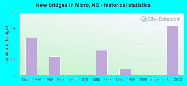
- New bridges - historical statistics
- 61950-1959
- 31960-1969
- 41980-1989
- 11990-1999
- 82010-2019


- Bridge Condition - Deck
- 30.8%Very good
- 46.2%Good
- 23.1%Satisfactory

- Bridge Condition - Superstructure
- 7.7%Excellent
- 23.1%Very good
- 30.8%Good
- 30.8%Satisfactory
- 7.7%Fair

- Bridge Condition - Substructure
- 7.7%Excellent
- 23.1%Very good
- 30.8%Good
- 30.8%Satisfactory
- 7.7%Fair

- Bridge Condition - Channel
- 7.1%Very good
- 78.6%Good
- 7.1%Satisfactory
- 7.1%Fair

- Bridge Condition - Culverts
- 66.7%Satisfactory
- 33.3%Fair
Find on map >> Show street view
Structure Number: 1010109, Location: 0.1 MI. N JCT SR2389 (Lat: 35.549564, Lng: -78.219664), Route carried "on" structure: State highway 2137, Year Built: 1956, Status: Open, Structure Length: 6.27m (20.57ft), Average Daily Traffic: 1,300 (year 2019), Truck Traffic: 6%, Average Future Daily Traffic: 2,600 (year 2040), Design Load: HS 15, Features Intersected: I95
Minimum Vertical Clearance: 30+ m (98+ ft), Kilometerpoint: 0.000, Lanes on structure: 2, Lanes under structure: 4, Owner: State Highway Agency, Approaching Roadway Width: 6.7m (22.0ft), Skew: 3 degrees, Material/Design: Steel, Design/Construction: Stringer/Multi-beam, Number Of Spans In Main Unit: 4, Length of Maximum Span: 17.3m (56.8ft), Curb or Sidewalk Widths: Left: 0.4m (1.3ft), Right: 0.4m (1.3ft), Curb-To-Curb Width: 7.9m (25.9ft), Out-to-Out Width: 9.6m (31.5ft)
Condition: Deck: Satisfactory, Superstructure: Satisfactory, Substructure: Satisfactory, Operating Rating: 45.3 metric tons, Method Used To Determine Operating Rating: Load Factor (LF), Inventory Rating: 27.2 metric tons, Method Used To Determine Inventory Rating: Load Factor (LF), Structural Evaluation: Equal to present minimum criteria, Deck Geometry: Meets minimum limits, Underclear: High priority of corrective action, Approach Roadway Alignment: Equal to present desirable criteria, Designated Inspection Frequency: Every 24 months, Inspection Date: July 2021, Deck Structure Type: Concrete Cast-file-Place, Wearing Surface/Protective System: Wearing Surface: Bituminous
Find on map >> Show street view
Structure Number: 1010111, Location: 0.5 MI. S. JCT. US301 (Lat: 35.560911, Lng: -78.187422), Route carried "on" structure: State highway 2141, Year Built: 2019, Status: Open, Structure Length: 6.67m (21.88ft), Average Daily Traffic: 1,400 (year 2017), Truck Traffic: 6%, Average Future Daily Traffic: 2,800 (year 2040), Design Load: HL 93, Features Intersected: I95
Minimum Vertical Clearance: 30+ m (98+ ft), Kilometerpoint: 0.000, Lanes on structure: 2, Lanes under structure: 4, Owner: State Highway Agency, Approaching Roadway Width: 11.2m (36.7ft), Skew: 1 degrees, Material/Design: Steel, Design/Construction: Stringer/Multi-beam, Number Of Spans In Main Unit: 2, Length of Maximum Span: 32.6m (107.0ft), Curb-To-Curb Width: 10.9m (35.8ft), Out-to-Out Width: 11.9m (39.0ft)
Condition: Deck: Very good, Superstructure: Excellent, Substructure: Excellent, Operating Rating: 89.8 metric tons, Method Used To Determine Operating Rating: Load and Resistance Factor (LRFR), Inventory Rating: 80.7 metric tons, Method Used To Determine Inventory Rating: Load and Resistance Factor (LRFR), Structural Evaluation: Superior to present desirable criteria, Deck Geometry: Equal to present minimum criteria, Underclear: High priority of corrective action, Approach Roadway Alignment: Equal to present desirable criteria, Designated Inspection Frequency: Every 24 months, Inspection Date: March 2020, Deck Structure Type: Concrete Cast-file-Place, Wearing Surface/Protective System: Wearing Surface: Monolithic Concrete, Deck Protection: Epoxy Coated Reinforcing
Find on map >> Show street view
Structure Number: 1010219, Location: 0.7 MI W JCT SR2363 (Lat: 35.546414, Lng: -78.205508), Route carried "on" structure: State highway 1001, Year Built: 1982, Status: Open, Structure Length: 1.88m (6.17ft), Average Daily Traffic: 2,200 (year 2018), Truck Traffic: 6%, Average Future Daily Traffic: 4,400 (year 2040), Design Load: HS 20+Mod, Features Intersected: LITTLE CREEK
Minimum Vertical Clearance: 30+ m (98+ ft), Kilometerpoint: 0.000, Lanes on structure: 2, Owner: State Highway Agency, Approaching Roadway Width: 6.7m (22.0ft), Material/Design: Prestressed concrete, Design/Construction: Slab, Number Of Spans In Main Unit: 2, Length of Maximum Span: 8.8m (28.9ft), Curb-To-Curb Width: 7.5m (24.6ft), Out-to-Out Width: 8.3m (27.2ft)
Condition: Deck: Satisfactory, Superstructure: Satisfactory, Substructure: Good, Channel: Good, Operating Rating: 89.8 metric tons, Method Used To Determine Operating Rating: Load Factor (LF), Inventory Rating: 59.8 metric tons, Method Used To Determine Inventory Rating: Load Factor (LF), Structural Evaluation: Equal to present minimum criteria, Deck Geometry: High priority of replacement, Waterway Adequacy: Better than present minimum criteria, Approach Roadway Alignment: Equal to present desirable criteria, Designated Inspection Frequency: Every 24 months, Underwater Inspection Frequency: Every 60 months, Inspection Date: October 2021, Underwater Inspection Date: November 2021, Deck Structure Type: Concrete Precast Panels, Wearing Surface/Protective System: Wearing Surface: Bituminous
Find on map >> Show street view
Structure Number: 101022, Location: 0.6MI E JCT SR1001 (Lat: 35.535606, Lng: -78.201331), Route carried "on" structure: State highway 2363, Year Built: 1989, Status: Open, Structure Length: 2.13m (6.99ft), Average Daily Traffic: 250 (year 2019), Truck Traffic: 6%, Average Future Daily Traffic: 500 (year 2040), Design Load: HS 20+Mod, Features Intersected: LITTLE CREEK
Minimum Vertical Clearance: 30+ m (98+ ft), Kilometerpoint: 0.000, Lanes on structure: 2, Owner: State Highway Agency, Approaching Roadway Width: 6.0m (19.7ft), Material/Design: Prestressed concrete, Design/Construction: Slab, Number Of Spans In Main Unit: 2, Length of Maximum Span: 9.7m (31.8ft), Curb-To-Curb Width: 7.3m (24.0ft), Out-to-Out Width: 8.2m (26.9ft)
Condition: Deck: Good, Superstructure: Good, Substructure: Fair, Channel: Good, Operating Rating: 89.8 metric tons, Method Used To Determine Operating Rating: Load Factor (LF), Inventory Rating: 57.1 metric tons, Method Used To Determine Inventory Rating: Load Factor (LF), Structural Evaluation: Somewhat better than minimum adequacy, Deck Geometry: Somewhat better than minimum adequacy, Waterway Adequacy: Better than present minimum criteria, Approach Roadway Alignment: Equal to present desirable criteria, Designated Inspection Frequency: Every 24 months, Inspection Date: October 2021, Deck Structure Type: Concrete Precast Panels, Wearing Surface/Protective System: Wearing Surface: Bituminous
Find on map >> Show street view
Structure Number: 1010222, Location: 0.3 MI W JCT SR2364 (Lat: 35.518806, Lng: -78.196417), Route carried "on" structure: State highway 2320, Year Built: 2014, Status: Open, Structure Length: 3.10m (10.17ft), Average Daily Traffic: 640 (year 2018), Truck Traffic: 6%, Average Future Daily Traffic: 1,280 (year 2040), Design Load: HL 93, Features Intersected: LITTLE CREEK
Minimum Vertical Clearance: 30+ m (98+ ft), Kilometerpoint: 0.000, Lanes on structure: 2, Owner: State Highway Agency, Approaching Roadway Width: 8.5m (27.9ft), Material/Design: Prestressed concrete, Design/Construction: Slab, Number Of Spans In Main Unit: 2, Length of Maximum Span: 14.9m (48.9ft), Curb-To-Curb Width: 8.2m (26.9ft), Out-to-Out Width: 9.1m (29.9ft)
Condition: Deck: Very good, Superstructure: Very good, Substructure: Good, Channel: Very good, Operating Rating: 69.8 metric tons, Method Used To Determine Operating Rating: Load and Resistance Factor (LRFR), Inventory Rating: 53.5 metric tons, Method Used To Determine Inventory Rating: Load and Resistance Factor (LRFR), Structural Evaluation: Better than present minimum criteria, Deck Geometry: Somewhat better than minimum adequacy, Waterway Adequacy: Equal to present desirable criteria, Approach Roadway Alignment: Equal to present desirable criteria, Designated Inspection Frequency: Every 24 months, Underwater Inspection Frequency: Every 60 months, Inspection Date: July 2020, Underwater Inspection Date: March 2021, Deck Structure Type: Concrete Precast Panels, Wearing Surface/Protective System: Wearing Surface: Bituminous, Deck Protection: Epoxy Coated Reinforcing
Find on map >> Show street view
Structure Number: 1010237, Location: 0.1 MI S JCT SR1934 (Lat: 35.600494, Lng: -78.197214), Route carried "on" structure: State highway 2129, Year Built: 1997, Status: Open, Structure Length: 3.10m (10.17ft), Average Daily Traffic: 160 (year 2000), Truck Traffic: 6%, Average Future Daily Traffic: 320 (year 2025), Design Load: HS 20+Mod, Features Intersected: LITTLE RIVER
Minimum Vertical Clearance: 30+ m (98+ ft), Kilometerpoint: 0.000, Lanes on structure: 2, Owner: State Highway Agency, Approaching Roadway Width: 8.2m (26.9ft), Material/Design: Prestressed concrete, Design/Construction: Slab, Number Of Spans In Main Unit: 3, Length of Maximum Span: 14.9m (48.9ft), Curb-To-Curb Width: 8.2m (26.9ft), Out-to-Out Width: 9.0m (29.5ft)
Condition: Deck: Good, Superstructure: Good, Substructure: Good, Channel: Satisfactory, Operating Rating: 76.2 metric tons, Method Used To Determine Operating Rating: Load Factor (LF), Inventory Rating: 45.3 metric tons, Method Used To Determine Inventory Rating: Load Factor (LF), Structural Evaluation: Better than present minimum criteria, Deck Geometry: Somewhat better than minimum adequacy, Waterway Adequacy: Better than present minimum criteria, Approach Roadway Alignment: Equal to present desirable criteria, Designated Inspection Frequency: Every 24 months, Inspection Date: September 2020, Deck Structure Type: Concrete Precast Panels, Wearing Surface/Protective System: Wearing Surface: Bituminous
Find on map >> Show street view
Structure Number: 1010239, Location: 0.3 MI. NORTH OF SR1934 (Lat: 35.590811, Lng: -78.227153), Route carried "on" structure: State highway 2129, Year Built: 2018, Status: Open, Structure Length: 4.78m (15.68ft), Average Daily Traffic: 465 (year 2015), Truck Traffic: 6%, Average Future Daily Traffic: 930 (year 2040), Design Load: HL 93, Features Intersected: BUFFALO CREEK
Minimum Vertical Clearance: 30+ m (98+ ft), Kilometerpoint: 0.000, Lanes on structure: 2, Owner: State Highway Agency, Approaching Roadway Width: 8.5m (27.9ft), Material/Design: Prestressed concrete, Design/Construction: Slab, Number Of Spans In Main Unit: 3, Length of Maximum Span: 16.4m (53.8ft), Curb-To-Curb Width: 8.2m (26.9ft), Out-to-Out Width: 9.1m (29.9ft)
Condition: Deck: Very good, Superstructure: Very good, Substructure: Very good, Channel: Good, Operating Rating: 61.6 metric tons, Method Used To Determine Operating Rating: Load and Resistance Factor (LRFR), Inventory Rating: 42.6 metric tons, Method Used To Determine Inventory Rating: Load and Resistance Factor (LRFR), Structural Evaluation: Equal to present desirable criteria, Deck Geometry: Somewhat better than minimum adequacy, Waterway Adequacy: Better than present minimum criteria, Approach Roadway Alignment: Equal to present desirable criteria, Designated Inspection Frequency: Every 24 months, Inspection Date: July 2020, Deck Structure Type: Concrete Cast-file-Place, Wearing Surface/Protective System: Wearing Surface: Bituminous
Find on map >> Show street view
Structure Number: 101024, Location: 0.5 MI N. JCT SR1938 (Lat: 35.600939, Lng: -78.238172), Route carried "on" structure: State highway 2127, Year Built: 2014, Status: Open, Structure Length: 2.13m (6.99ft), Average Daily Traffic: 550 (year 2019), Truck Traffic: 6%, Average Future Daily Traffic: 1,100 (year 2040), Design Load: HL 93, Features Intersected: BUFFALO CREEK
Minimum Vertical Clearance: 30+ m (98+ ft), Kilometerpoint: 0.000, Lanes on structure: 2, Owner: State Highway Agency, Approaching Roadway Width: 8.5m (27.9ft), Material/Design: Prestressed concrete, Design/Construction: Slab, Number Of Spans In Main Unit: 1, Length of Maximum Span: 21.0m (68.9ft), Curb-To-Curb Width: 8.2m (26.9ft), Out-to-Out Width: 9.1m (29.9ft)
Condition: Deck: Good, Superstructure: Good, Substructure: Good, Channel: Good, Operating Rating: 75.2 metric tons, Method Used To Determine Operating Rating: Load and Resistance Factor (LRFR), Inventory Rating: 57.1 metric tons, Method Used To Determine Inventory Rating: Load and Resistance Factor (LRFR), Structural Evaluation: Better than present minimum criteria, Deck Geometry: Somewhat better than minimum adequacy, Waterway Adequacy: Better than present minimum criteria, Approach Roadway Alignment: Equal to present minimum criteria, Designated Inspection Frequency: Every 24 months, Inspection Date: October 2020, Deck Structure Type: Concrete Precast Panels, Wearing Surface/Protective System: Wearing Surface: Bituminous, Deck Protection: Epoxy Coated Reinforcing
Find on map >> Show street view
Structure Number: 1010241, Location: 1.3 MI. N. JCT. SR1938 (Lat: 35.615694, Lng: -78.232250), Route carried "on" structure: State highway 2127, Year Built: 2014, Status: Open, Structure Length: 2.19m (7.19ft), Average Daily Traffic: 550 (year 2019), Truck Traffic: 6%, Average Future Daily Traffic: 1,100 (year 2040), Design Load: HL 93, Features Intersected: LONG BRANCH
Minimum Vertical Clearance: 30+ m (98+ ft), Kilometerpoint: 0.000, Lanes on structure: 2, Owner: State Highway Agency, Approaching Roadway Width: 9.1m (29.9ft), Skew: 1 degrees, Material/Design: Prestressed concrete, Design/Construction: Slab, Number Of Spans In Main Unit: 1, Length of Maximum Span: 21.6m (70.9ft), Curb-To-Curb Width: 8.2m (26.9ft), Out-to-Out Width: 9.1m (29.9ft)
Condition: Deck: Good, Superstructure: Good, Substructure: Very good, Channel: Good, Operating Rating: 67.1 metric tons, Method Used To Determine Operating Rating: Load and Resistance Factor (LRFR), Inventory Rating: 50.8 metric tons, Method Used To Determine Inventory Rating: Load and Resistance Factor (LRFR), Structural Evaluation: Better than present minimum criteria, Deck Geometry: Somewhat better than minimum adequacy, Waterway Adequacy: Better than present minimum criteria, Approach Roadway Alignment: Equal to present desirable criteria, Designated Inspection Frequency: Every 24 months, Inspection Date: October 2020, Deck Structure Type: Concrete Precast Panels, Wearing Surface/Protective System: Wearing Surface: Bituminous, Deck Protection: Epoxy Coated Reinforcing
Find on map >> Show street view
Structure Number: 1010242, Location: 1.3 MI. W. JCT. SR2170 (Lat: 35.619708, Lng: -78.222253), Route carried "on" structure: State highway 2127, Year Built: 1956, Status: Open, Structure Length: 3.26m (10.70ft), Average Daily Traffic: 550 (year 2019), Truck Traffic: 6%, Average Future Daily Traffic: 1,100 (year 2040), Features Intersected: LITTLE RIVER
Minimum Vertical Clearance: 30+ m (98+ ft), Kilometerpoint: 0.000, Lanes on structure: 2, Owner: State Highway Agency, Approaching Roadway Width: 6.0m (19.7ft), Material/Design: Steel, Design/Construction: Stringer/Multi-beam, Number Of Spans In Main Unit: 3, Length of Maximum Span: 10.3m (33.8ft), Curb-To-Curb Width: 7.2m (23.6ft), Out-to-Out Width: 8.6m (28.2ft)
Condition: Deck: Good, Superstructure: Satisfactory, Substructure: Satisfactory, Channel: Fair, Operating Rating: 44.4 metric tons, Method Used To Determine Operating Rating: Load Factor (LF), Inventory Rating: 26.3 metric tons, Method Used To Determine Inventory Rating: Load Factor (LF), Structural Evaluation: Equal to present minimum criteria, Deck Geometry: Meets minimum limits, Waterway Adequacy: Better than present minimum criteria, Approach Roadway Alignment: Equal to present desirable criteria, Designated Inspection Frequency: Every 24 months, Inspection Date: July 2021, Deck Structure Type: Concrete Cast-file-Place, Wearing Surface/Protective System: Wearing Surface: Bituminous
Find on map >> Show street view
Structure Number: 1010282, Location: 0.2 MI.N.SR1934 (Lat: 35.588292, Lng: -78.211550), Route carried "on" structure: State highway 2130, Year Built: 2015, Status: Open, Structure Length: 5.27m (17.29ft), Average Daily Traffic: 500 (year 2019), Truck Traffic: 6%, Average Future Daily Traffic: 1,000 (year 2040), Design Load: HL 93, Features Intersected: BUFFALO CREEK
Minimum Vertical Clearance: 30+ m (98+ ft), Kilometerpoint: 0.000, Lanes on structure: 2, Owner: State Highway Agency, Approaching Roadway Width: 9.1m (29.9ft), Material/Design: Prestressed concrete, Design/Construction: Slab, Number Of Spans In Main Unit: 3, Number Of Approach Spans: 2, Length of Maximum Span: 21.0m (68.9ft), Curb-To-Curb Width: 9.1m (29.9ft), Out-to-Out Width: 10.0m (32.8ft)
Condition: Deck: Very good, Superstructure: Very good, Substructure: Very good, Channel: Good, Operating Rating: 71.6 metric tons, Method Used To Determine Operating Rating: Load and Resistance Factor (LRFR), Inventory Rating: 50.8 metric tons, Method Used To Determine Inventory Rating: Load and Resistance Factor (LRFR), Structural Evaluation: Equal to present desirable criteria, Deck Geometry: Equal to present minimum criteria, Waterway Adequacy: Better than present minimum criteria, Approach Roadway Alignment: Equal to present desirable criteria, Designated Inspection Frequency: Every 24 months, Inspection Date: October 2021, Deck Structure Type: Concrete Precast Panels, Wearing Surface/Protective System: Wearing Surface: Bituminous, Deck Protection: Epoxy Coated Reinforcing
Find on map >> Show street view
Structure Number: 1010354, Location: 0.1MI.N.JCT.SR2129 (Lat: 35.608825, Lng: -78.210131), Route carried "on" structure: State highway 2130, Year Built: 1963, Status: Open, Structure Length: 5.02m (16.47ft), Average Daily Traffic: 500 (year 2019), Truck Traffic: 6%, Average Future Daily Traffic: 1,000 (year 2040), Design Load: H 15, Features Intersected: LITTLE RIVER
Minimum Vertical Clearance: 30+ m (98+ ft), Kilometerpoint: 0.000, Lanes on structure: 2, Owner: State Highway Agency, Approaching Roadway Width: 6.4m (21.0ft), Skew: 4 degrees, Material/Design: Steel, Design/Construction: Stringer/Multi-beam, Number Of Spans In Main Unit: 3, Length of Maximum Span: 16.4m (53.8ft), Curb or Sidewalk Widths: Left: 0.3m (1.0ft), Right: 0.3m (1.0ft), Curb-To-Curb Width: 7.3m (24.0ft), Out-to-Out Width: 8.6m (28.2ft)
Condition: Deck: Good, Superstructure: Fair, Substructure: Satisfactory, Channel: Good, Operating Rating: 53.5 metric tons, Method Used To Determine Operating Rating: Load Factor (LF), Inventory Rating: 31.7 metric tons, Method Used To Determine Inventory Rating: Load Factor (LF), Structural Evaluation: Somewhat better than minimum adequacy, Deck Geometry: Meets minimum limits, Waterway Adequacy: Better than present minimum criteria, Approach Roadway Alignment: Equal to present desirable criteria, Designated Inspection Frequency: Every 24 months, Inspection Date: June 2021, Deck Structure Type: Concrete Cast-file-Place, Wearing Surface/Protective System: Wearing Surface: Bituminous
Find on map >> Show street view
Structure Number: 1010446, Location: 0.2MI S.JCT SR1934 (Lat: 35.611367, Lng: -78.207367), Route carried "on" structure: State highway 2130, Year Built: 1963, Status: Open, Structure Length: 2.77m (9.09ft), Average Daily Traffic: 500 (year 2019), Truck Traffic: 6%, Average Future Daily Traffic: 1,000 (year 2040), Design Load: H 15, Features Intersected: LITTLE RIVER OVERFLOW
Minimum Vertical Clearance: 30+ m (98+ ft), Kilometerpoint: 0.000, Lanes on structure: 2, Owner: State Highway Agency, Approaching Roadway Width: 6.0m (19.7ft), Material/Design: Concrete continuous, Design/Construction: Slab, Number Of Spans In Main Unit: 4, Length of Maximum Span: 6.4m (21.0ft), Curb or Sidewalk Widths: Left: 0.3m (1.0ft), Right: 0.3m (1.0ft), Curb-To-Curb Width: 7.3m (24.0ft), Out-to-Out Width: 8.6m (28.2ft)
Condition: Deck: Satisfactory, Superstructure: Satisfactory, Substructure: Satisfactory, Channel: Good, Operating Rating: 43.5 metric tons, Method Used To Determine Operating Rating: Load Factor (LF), Inventory Rating: 26.3 metric tons, Method Used To Determine Inventory Rating: Load Factor (LF), Structural Evaluation: Equal to present minimum criteria, Deck Geometry: Meets minimum limits, Waterway Adequacy: Somewhat better than minimum adequacy, Approach Roadway Alignment: Equal to present desirable criteria, Designated Inspection Frequency: Every 24 months, Inspection Date: April 2021, Deck Structure Type: Concrete Cast-file-Place, Wearing Surface/Protective System: Wearing Surface: Bituminous
Find on map >> Show street view
Structure Number: 1010462, Location: 0.3 MI.N. OF JCT.I-95 (Lat: 35.554061, Lng: -78.219142), Route carried "on" structure: State highway 2137, Year Built: 1985, Status: Open, Structure Length: 1.06m (3.48ft), Average Daily Traffic: 1,200 (year 2019), Truck Traffic: 6%, Average Future Daily Traffic: 2,400 (year 2040), Design Load: HS 20+Mod, Features Intersected: LITTLE CREEK
Minimum Vertical Clearance: 30+ m (98+ ft), Kilometerpoint: 0.000, Lanes on structure: 2, Owner: State Highway Agency, Approaching Roadway Width: 5.7m (18.7ft), Skew: 4 degrees, Material/Design: Steel, Design/Construction: Culvert, Number Of Spans In Main Unit: 2, Length of Maximum Span: 3.0m (9.8ft)
Condition: Channel: Good, Culverts: Satisfactory, Operating Rating: 89.8 metric tons, Method Used To Determine Operating Rating: Load and Resistance Factor (LRFR), Inventory Rating: 89.8 metric tons, Method Used To Determine Inventory Rating: Load and Resistance Factor (LRFR), Structural Evaluation: Equal to present minimum criteria, Waterway Adequacy: Equal to present minimum criteria, Approach Roadway Alignment: Equal to present desirable criteria, Designated Inspection Frequency: Every 24 months, Inspection Date: October 2020
Find on map >> Show street view
Structure Number: 1010463, Location: 0.01MI.N.JCT. SR 2139 (Lat: 35.569539, Lng: -78.191236), Route carried "on" structure: State highway 2141, Year Built: 1985, Status: Open, Structure Length: 0.76m (2.49ft), Average Daily Traffic: 700 (year 2017), Truck Traffic: 6%, Average Future Daily Traffic: 1,400 (year 2040), Design Load: HS 20, Features Intersected: BIG BRANCH
Minimum Vertical Clearance: 30+ m (98+ ft), Kilometerpoint: 0.000, Lanes on structure: 2, Owner: State Highway Agency, Approaching Roadway Width: 5.7m (18.7ft), Material/Design: Steel, Design/Construction: Culvert, Number Of Spans In Main Unit: 3, Length of Maximum Span: 2.1m (6.9ft)
Condition: Channel: Good, Culverts: Fair, Operating Rating: 89.8 metric tons, Method Used To Determine Operating Rating: Load and Resistance Factor (LRFR), Inventory Rating: 89.8 metric tons, Method Used To Determine Inventory Rating: Load and Resistance Factor (LRFR), Structural Evaluation: Somewhat better than minimum adequacy, Waterway Adequacy: Better than present minimum criteria, Approach Roadway Alignment: Equal to present desirable criteria, Designated Inspection Frequency: Every 24 months, Inspection Date: October 2021
Find on map >> Show street view
Structure Number: 1010529, Location: 0.1 MI.N.SR2137 (Lat: 35.551069, Lng: -78.215803), Route carried "on" structure: Interstate 95, Year Built: 1960, Status: Open, Structure Length: 0.70m (2.30ft), Average Daily Traffic: 40,000 (year 2019), Truck Traffic: 23%, Average Future Daily Traffic: 80,000 (year 2040), Design Load: HS 20+Mod, Features Intersected: LITTLE CREEK
Minimum Vertical Clearance: 30+ m (98+ ft), Kilometerpoint: 30.937, Lanes on structure: 10, Base Highway Network: Yes (Inventory Route: 1, Subroute: 95), Owner: State Highway Agency, Approaching Roadway Width: 32.9m (107.9ft), Material/Design: Concrete continuous, Design/Construction: Culvert, Number Of Spans In Main Unit: 2, Length of Maximum Span: 3.3m (10.8ft)
Condition: Channel: Good, Culverts: Satisfactory, Operating Rating: 41.7 metric tons, Method Used To Determine Operating Rating: Field evaluation and documented engineering judgment, Inventory Rating: 32.6 metric tons, Method Used To Determine Inventory Rating: Field evaluation and documented engineering judgment, Structural Evaluation: Equal to present minimum criteria, Waterway Adequacy: Better than present minimum criteria, Approach Roadway Alignment: Equal to present desirable criteria, Designated Inspection Frequency: Every 24 months, Inspection Date: December 2020
Find on map >> Show street view
Structure Number: 1010109, Location: 0.1 MI. N JCT SR2389 (Lat: 35.549564, Lng: -78.219664), Route carried "under" structure: Interstate 95, Year Built: 1956, Structure Length: 0. m, Average Daily Traffic: 20,000 (year 2019), Truck Traffic: 23%, Features Intersected: SR2137
Minimum Vertical Clearance: 5.05m (16.57ft), Kilometerpoint: 30.907, Lanes on structure: 2, Lanes under structure: 2, Material/Design: Steel, Design/Construction: Stringer/Multi-beam, Length of Maximum Span: 17.3m (56.8ft)
Find on map >> Show street view
Structure Number: 101011, Location: 0.2 MI. W. JCT. SR2335 (Lat: 35.556408, Lng: -78.200939), Route carried "under" structure: Interstate 95, Year Built: 1956, Structure Length: 0. m, Average Daily Traffic: 19,500 (year 2018), Truck Traffic: 23%, Features Intersected: SR2130
Minimum Vertical Clearance: 4.77m (15.65ft), Kilometerpoint: 31.242, Lanes on structure: 2, Lanes under structure: 2, Material/Design: Steel, Design/Construction: Stringer/Multi-beam, Length of Maximum Span: 15.8m (51.8ft)
Find on map >> Show street view
Structure Number: 1010111, Location: 0.5 MI. S. JCT. US301 (Lat: 35.560911, Lng: -78.187422), Route carried "under" structure: Interstate 95, Year Built: 2019, Structure Length: 0. m, Average Daily Traffic: 19,250 (year 2018), Truck Traffic: 23%, Features Intersected: SR2141
Minimum Vertical Clearance: 5.66m (18.57ft), Kilometerpoint: 0.000, Lanes on structure: 2, Lanes under structure: 2, Material/Design: Steel, Design/Construction: Stringer/Multi-beam, Length of Maximum Span: 32.6m (107.0ft)