Bridge Statistics for Middleburg, North Carolina (NC)
Condition, Traffic, Stress, Structural Evaluation, Project Costs
- National Bridge Inventory (NBI) Statistics
- 18Number of bridges
- 105ft / 31.6mTotal length
- 129,430Total average daily traffic
- 27,296Total average daily truck traffic
- National Bridge Inventory (NBI) Registered Bridges for Middleburg
- No street view available for this location
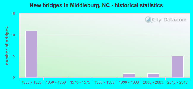
- New bridges - historical statistics
- 111950-1959
- 11990-1999
- 12000-2009
- 52010-2019


- Bridge Condition - Deck
- 12.5%Very good
- 75.0%Good
- 12.5%Satisfactory

- Bridge Condition - Superstructure
- 12.5%Excellent
- 25.0%Very good
- 25.0%Good
- 25.0%Satisfactory
- 12.5%Fair

- Bridge Condition - Substructure
- 25.0%Very good
- 25.0%Good
- 50.0%Satisfactory
Find on map >> Show street view
Structure Number: 1810036, Location: 0.9 MI W. SR1371 (Lat: 36.414244, Lng: -78.360967), Route carried "on" structure: State highway 1374, Year Built: 2017, Status: Open, Structure Length: 2.95m (9.68ft), Average Daily Traffic: 550 (year 2019), Truck Traffic: 6%, Average Future Daily Traffic: 1,100 (year 2040), Design Load: HL 93, Features Intersected: ANDERSON CREEK
Minimum Vertical Clearance: 30+ m (98+ ft), Kilometerpoint: 0.000, Lanes on structure: 2, Owner: State Highway Agency, Approaching Roadway Width: 9.1m (29.9ft), Material/Design: Prestressed concrete, Design/Construction: Box Beam or Girders - Multiple, Number Of Spans In Main Unit: 1, Length of Maximum Span: 28.6m (93.8ft), Curb-To-Curb Width: 9.1m (29.9ft), Out-to-Out Width: 10.0m (32.8ft)
Condition: Deck: Very good, Superstructure: Very good, Substructure: Very good, Channel: Good, Operating Rating: 79.8 metric tons, Method Used To Determine Operating Rating: Load and Resistance Factor (LRFR), Inventory Rating: 58.0 metric tons, Method Used To Determine Inventory Rating: Load and Resistance Factor (LRFR), Structural Evaluation: Equal to present desirable criteria, Deck Geometry: Equal to present minimum criteria, Waterway Adequacy: Better than present minimum criteria, Approach Roadway Alignment: Equal to present desirable criteria, Designated Inspection Frequency: Every 24 months, Inspection Date: August 2021, Deck Structure Type: Concrete Precast Panels, Wearing Surface/Protective System: Wearing Surface: Bituminous, Deck Protection: Epoxy Coated Reinforcing
Find on map >> Show street view
Structure Number: 1810041, Location: 1.0 MI S JCT US1 (Lat: 36.385442, Lng: -78.317678), Route carried "on" structure: State highway 1501, Year Built: 1950, Status: Posted for load, Structure Length: 0.79m (2.59ft), Average Daily Traffic: 720 (year 2016), Truck Traffic: 6%, Average Future Daily Traffic: 1,440 (year 2040), Features Intersected: FISHING CREEK
Minimum Vertical Clearance: 30+ m (98+ ft), Kilometerpoint: 0.000, Lanes on structure: 2, Owner: State Highway Agency, Approaching Roadway Width: 5.4m (17.7ft), Material/Design: Steel, Design/Construction: Stringer/Multi-beam, Number Of Spans In Main Unit: 1, Length of Maximum Span: 7.3m (24.0ft), Curb or Sidewalk Widths: Left: 0.2m (0.7ft), Right: 0.2m (0.7ft), Curb-To-Curb Width: 7.2m (23.6ft), Out-to-Out Width: 8.3m (27.2ft)
Condition: Deck: Good, Superstructure: Fair, Substructure: Satisfactory, Channel: Good, Operating Rating: 29.0 metric tons, Method Used To Determine Operating Rating: Load Factor (LF), Inventory Rating: 17.2 metric tons, Method Used To Determine Inventory Rating: Load Factor (LF), Structural Evaluation: Meets minimum limits, Deck Geometry: Meets minimum limits, Waterway Adequacy: Better than present minimum criteria, Approach Roadway Alignment: Equal to present desirable criteria, Bridge Posting: Required (Relationship of Operating Rating to Maximum Legal Load: > 39.9% below), Designated Inspection Frequency: Every 24 months, Inspection Date: January 2022, Deck Structure Type: Concrete Cast-file-Place, Wearing Surface/Protective System: Wearing Surface: Bituminous
Find on map >> Show street view
Structure Number: 1810061, Location: 1.8MI. N. JCT. US1 CONN. (Lat: 36.393111, Lng: -78.338297), Route carried "on" structure: Interstate 85, Year Built: 2018, Status: Open, Structure Length: 3.65m (11.98ft), Average Daily Traffic: 14,000 (year 2019), Truck Traffic: 16%, Average Future Daily Traffic: 28,000 (year 2040), Design Load: HL 93, Features Intersected: SR1371
Minimum Vertical Clearance: 30+ m (98+ ft), Kilometerpoint: 0.000, Lanes on structure: 3, Lanes under structure: 2, Base Highway Network: Yes (Inventory Route: 1, Subroute: 85), Owner: State Highway Agency, Approaching Roadway Width: 14.6m (47.9ft), Skew: 11 degrees, Material/Design: Prestressed concrete, Design/Construction: Stringer/Multi-beam, Number Of Spans In Main Unit: 1, Length of Maximum Span: 35.0m (114.8ft), Curb-To-Curb Width: 14.4m (47.2ft), Out-to-Out Width: 15.6m (51.2ft)
Condition: Deck: Good, Superstructure: Very good, Substructure: Very good, Operating Rating: 78.0 metric tons, Method Used To Determine Operating Rating: Load and Resistance Factor (LRFR), Inventory Rating: 53.5 metric tons, Method Used To Determine Inventory Rating: Load and Resistance Factor (LRFR), Structural Evaluation: Equal to present desirable criteria, Deck Geometry: Meets minimum limits, Underclear: Equal to present minimum criteria, Approach Roadway Alignment: Equal to present desirable criteria, Designated Inspection Frequency: Every 24 months, Inspection Date: June 2021, Deck Structure Type: Concrete Cast-file-Place, Wearing Surface/Protective System: Wearing Surface: Monolithic Concrete, Deck Protection: Epoxy Coated Reinforcing
Find on map >> Show street view
Structure Number: 1810063, Location: 1.8 MI. N. JCT. US1 CONN. (Lat: 36.393183, Lng: -78.338486), Route carried "on" structure: Interstate 85, Year Built: 2017, Status: Open, Structure Length: 3.59m (11.78ft), Average Daily Traffic: 14,000 (year 2019), Truck Traffic: 23%, Average Future Daily Traffic: 28,000 (year 2040), Design Load: HL 93, Features Intersected: SR1371
Minimum Vertical Clearance: 30+ m (98+ ft), Kilometerpoint: 67.056, Lanes on structure: 3, Lanes under structure: 2, Base Highway Network: Yes (Inventory Route: 1, Subroute: 85), Owner: State Highway Agency, Approaching Roadway Width: 14.6m (47.9ft), Skew: 11 degrees, Material/Design: Prestressed concrete, Design/Construction: Slab, Number Of Spans In Main Unit: 1, Length of Maximum Span: 34.7m (113.8ft), Curb-To-Curb Width: 14.4m (47.2ft), Out-to-Out Width: 15.6m (51.2ft)
Condition: Deck: Good, Superstructure: Excellent, Substructure: Good, Operating Rating: 73.4 metric tons, Method Used To Determine Operating Rating: Load and Resistance Factor (LRFR), Inventory Rating: 49.8 metric tons, Method Used To Determine Inventory Rating: Load and Resistance Factor (LRFR), Structural Evaluation: Better than present minimum criteria, Deck Geometry: Meets minimum limits, Underclear: Better than present minimum criteria, Approach Roadway Alignment: Equal to present desirable criteria, Designated Inspection Frequency: Every 24 months, Inspection Date: June 2021, Deck Structure Type: Concrete Cast-file-Place, Wearing Surface/Protective System: Wearing Surface: Monolithic Concrete, Deck Protection: Epoxy Coated Reinforcing
Find on map >> Show street view
Structure Number: 1810064, Location: 0.6 MI. N. OF US-1 (Lat: 36.406975, Lng: -78.326603), Route carried "on" structure: State highway 1369, Year Built: 1957, Status: Open, Structure Length: 8.59m (28.18ft), Average Daily Traffic: 2,600 (year 2018), Truck Traffic: 7%, Average Future Daily Traffic: 5,200 (year 2040), Design Load: HS 20+Mod, Features Intersected: I85
Minimum Vertical Clearance: 30+ m (98+ ft), Kilometerpoint: 0.000, Lanes on structure: 2, Lanes under structure: 3, Owner: State Highway Agency, Approaching Roadway Width: 7.3m (24.0ft), Skew: 4 degrees, Material/Design: Prestressed concrete, Design/Construction: Stringer/Multi-beam, Number Of Spans In Main Unit: 4, Length of Maximum Span: 20.7m (67.9ft), Curb or Sidewalk Widths: Left: 0.3m (1.0ft), Right: 0.3m (1.0ft), Curb-To-Curb Width: 7.3m (24.0ft), Out-to-Out Width: 8.6m (28.2ft)
Condition: Deck: Good, Superstructure: Satisfactory, Substructure: Satisfactory, Operating Rating: 76.2 metric tons, Method Used To Determine Operating Rating: Load Factor (LF), Inventory Rating: 34.4 metric tons, Method Used To Determine Inventory Rating: Load Factor (LF), Structural Evaluation: Equal to present minimum criteria, Deck Geometry: High priority of replacement, Underclear: High priority of corrective action, Approach Roadway Alignment: Equal to present desirable criteria, Designated Inspection Frequency: Every 24 months, Inspection Date: Febuary 2022, Deck Structure Type: Concrete Cast-file-Place, Wearing Surface/Protective System: Wearing Surface: Monolithic Concrete, Deck Protection: Epoxy Coated Reinforcing
Find on map >> Show street view
Structure Number: 185001, Location: 0.9 MI.N JCT US1 (Lat: 36.430794, Lng: -78.295558), Route carried "on" structure: State highway 1237, Year Built: 1957, Status: Open, Structure Length: 6.55m (21.49ft), Average Daily Traffic: 2,000 (year 2019), Truck Traffic: 6%, Average Future Daily Traffic: 4,000 (year 2040), Design Load: HS 15, Features Intersected: I85
Minimum Vertical Clearance: 30+ m (98+ ft), Kilometerpoint: 0.000, Lanes on structure: 2, Lanes under structure: 2, Owner: State Highway Agency, Approaching Roadway Width: 7.6m (24.9ft), Skew: 1 degrees, Material/Design: Concrete, Design/Construction: Tee Beam, Number Of Spans In Main Unit: 4, Length of Maximum Span: 16.4m (53.8ft), Curb or Sidewalk Widths: Left: 0.4m (1.3ft), Right: 0.4m (1.3ft), Curb-To-Curb Width: 8.5m (27.9ft), Out-to-Out Width: 10.1m (33.1ft)
Condition: Deck: Satisfactory, Superstructure: Satisfactory, Substructure: Satisfactory, Operating Rating: 65.3 metric tons, Method Used To Determine Operating Rating: Load Factor (LF), Inventory Rating: 39.0 metric tons, Method Used To Determine Inventory Rating: Load Factor (LF), Structural Evaluation: Equal to present minimum criteria, Deck Geometry: Somewhat better than minimum adequacy, Underclear: High priority of corrective action, Approach Roadway Alignment: Equal to present desirable criteria, Designated Inspection Frequency: Every 24 months, Inspection Date: October 2021, Deck Structure Type: Concrete Cast-file-Place, Wearing Surface/Protective System: Wearing Surface: Bituminous
Find on map >> Show street view
Structure Number: 185002, Location: 0.3 MI N. OF SR1114 (Lat: 36.398783, Lng: -78.266575), Route carried "on" structure: State highway 1100, Year Built: 2009, Status: Open, Structure Length: 3.65m (11.98ft), Average Daily Traffic: 550 (year 2019), Truck Traffic: 6%, Average Future Daily Traffic: 1,100 (year 2040), Design Load: HL 93, Features Intersected: FISHING CREEK
Minimum Vertical Clearance: 30+ m (98+ ft), Kilometerpoint: 0.000, Lanes on structure: 2, Owner: State Highway Agency, Approaching Roadway Width: 8.5m (27.9ft), Skew: 1 degrees, Material/Design: Prestressed concrete, Design/Construction: Stringer/Multi-beam, Number Of Spans In Main Unit: 1, Length of Maximum Span: 35.3m (115.8ft), Curb-To-Curb Width: 8.7m (28.5ft), Out-to-Out Width: 9.7m (31.8ft)
Condition: Deck: Good, Superstructure: Good, Substructure: Good, Channel: Good, Operating Rating: 58.9 metric tons, Method Used To Determine Operating Rating: Load and Resistance Factor (LRFR), Inventory Rating: 39.9 metric tons, Method Used To Determine Inventory Rating: Load and Resistance Factor (LRFR), Structural Evaluation: Better than present minimum criteria, Deck Geometry: Somewhat better than minimum adequacy, Waterway Adequacy: Better than present minimum criteria, Approach Roadway Alignment: Equal to present desirable criteria, Designated Inspection Frequency: Every 24 months, Inspection Date: October 2021, Deck Structure Type: Concrete Cast-file-Place, Wearing Surface/Protective System: Wearing Surface: Monolithic Concrete, Deck Protection: Epoxy Coated Reinforcing
Find on map >> Show street view
Structure Number: 1850021, Location: 1.1 MI.N.JCT.SR1112 (Lat: 36.387744, Lng: -78.262336), Route carried "on" structure: State highway 1100, Year Built: 1990, Status: Open, Structure Length: 1.82m (5.97ft), Average Daily Traffic: 460 (year 2016), Truck Traffic: 6%, Average Future Daily Traffic: 920 (year 2040), Design Load: HS 20+Mod, Features Intersected: MATTHEWS CREEK
Minimum Vertical Clearance: 30+ m (98+ ft), Kilometerpoint: 0.000, Lanes on structure: 2, Owner: State Highway Agency, Approaching Roadway Width: 7.3m (24.0ft), Material/Design: Prestressed concrete, Design/Construction: Slab, Number Of Spans In Main Unit: 2, Length of Maximum Span: 8.5m (27.9ft), Curb-To-Curb Width: 7.3m (24.0ft), Out-to-Out Width: 8.3m (27.2ft)
Condition: Deck: Good, Superstructure: Good, Substructure: Satisfactory, Channel: Good, Operating Rating: 89.8 metric tons, Method Used To Determine Operating Rating: Load Factor (LF), Inventory Rating: 75.2 metric tons, Method Used To Determine Inventory Rating: Load Factor (LF), Structural Evaluation: Equal to present minimum criteria, Deck Geometry: Meets minimum limits, Waterway Adequacy: Better than present minimum criteria, Approach Roadway Alignment: Equal to present desirable criteria, Designated Inspection Frequency: Every 24 months, Underwater Inspection Frequency: Every 60 months, Inspection Date: May 2021, Underwater Inspection Date: Febuary 2022, Deck Structure Type: Concrete Precast Panels, Wearing Surface/Protective System: Wearing Surface: Bituminous
Find on map >> Show street view
Structure Number: 181006, Location: 0.2 MI. W. JCT. US1/158 (Lat: 36.382328, Lng: -78.348200), Route carried "under" structure: Interstate 85, Year Built: 1957, Structure Length: 0. m, Average Daily Traffic: 14,000 (year 2018), Truck Traffic: 23%, Features Intersected: SR1322
Minimum Vertical Clearance: 5.18m (16.99ft), Kilometerpoint: 66.752, Lanes on structure: 2, Lanes under structure: 2, Material/Design: Concrete, Design/Construction: Tee Beam, Length of Maximum Span: 17.6m (57.7ft)
Find on map >> Show street view
Structure Number: 181006, Location: 0.2 MI. W. JCT. US1/158 (Lat: 36.382328, Lng: -78.348200), Route carried "under" structure: Interstate 85, Year Built: 1957, Structure Length: 0. m, Average Daily Traffic: 14,000 (year 2018), Truck Traffic: 23%, Features Intersected: SR1322
Minimum Vertical Clearance: 4.77m (15.65ft), Kilometerpoint: 66.752, Lanes on structure: 2, Lanes under structure: 1, Material/Design: Concrete, Design/Construction: Tee Beam, Length of Maximum Span: 17.6m (57.7ft)
Find on map >> Show street view
Structure Number: 181006, Location: 0.2 MI. W. JCT. US1/158 (Lat: 36.382328, Lng: -78.348200), Route carried "under" structure: Interstate 85, Year Built: 1957, Structure Length: 0. m, Average Daily Traffic: 13,500 (year 2015), Truck Traffic: 23%, Features Intersected: SR1322
Minimum Vertical Clearance: 4.74m (15.55ft), Kilometerpoint: 66.721, Lanes on structure: 2, Lanes under structure: 1, Material/Design: Concrete, Design/Construction: Tee Beam, Length of Maximum Span: 17.6m (57.7ft)
Find on map >> Show street view
Structure Number: 1810061, Location: 1.8MI. N. JCT. US1 CONN. (Lat: 36.393111, Lng: -78.338297), Route carried "under" structure: State highway 1371, Year Built: 2018, Structure Length: 0. m, Average Daily Traffic: 1,000 (year 2019), Truck Traffic: 6%, Features Intersected: I85N
Minimum Vertical Clearance: 5.46m (17.91ft), Kilometerpoint: 0.000, Lanes on structure: 3, Lanes under structure: 2, Material/Design: Prestressed concrete, Design/Construction: Stringer/Multi-beam, Length of Maximum Span: 35.0m (114.8ft)
Find on map >> Show street view
Structure Number: 1810063, Location: 1.8 MI. N. JCT. US1 CONN. (Lat: 36.393183, Lng: -78.338486), Route carried "under" structure: State highway 1371, Year Built: 2017, Structure Length: 0. m, Average Daily Traffic: 1,000 (year 2019), Truck Traffic: 6%, Features Intersected: I85S
Minimum Vertical Clearance: 5.13m (16.83ft), Kilometerpoint: 0.000, Lanes on structure: 3, Lanes under structure: 2, Material/Design: Prestressed concrete, Design/Construction: Slab, Length of Maximum Span: 34.7m (113.8ft)
Find on map >> Show street view
Structure Number: 1810064, Location: 0.6 MI. N. OF US-1 (Lat: 36.406975, Lng: -78.326603), Route carried "under" structure: Interstate 85, Year Built: 1957, Structure Length: 0. m, Average Daily Traffic: 14,500 (year 2018), Truck Traffic: 23%, Features Intersected: SR1369
Minimum Vertical Clearance: 5.13m (16.83ft), Kilometerpoint: 0.000, Lanes on structure: 2, Lanes under structure: 1, Material/Design: Prestressed concrete, Design/Construction: Stringer/Multi-beam, Length of Maximum Span: 20.7m (67.9ft)
Find on map >> Show street view
Structure Number: 1810064, Location: 0.6 MI. N. OF US-1 (Lat: 36.406975, Lng: -78.326603), Route carried "under" structure: Interstate 85, Year Built: 1957, Structure Length: 0. m, Average Daily Traffic: 14,500 (year 2018), Truck Traffic: 23%, Features Intersected: SR1369
Minimum Vertical Clearance: 5.13m (16.83ft), Kilometerpoint: 67.270, Lanes on structure: 2, Lanes under structure: 2, Material/Design: Prestressed concrete, Design/Construction: Stringer/Multi-beam, Length of Maximum Span: 20.7m (67.9ft)
Find on map >> Show street view
Structure Number: 1810113, Location: 1.0 MI.N. OF US1/158 (Lat: 36.422950, Lng: -78.306264), Route carried "under" structure: State highway 1376, Year Built: 1957, Structure Length: 0. m, Average Daily Traffic: 50 (year 2018), Truck Traffic: 6%, Features Intersected: I85
Minimum Vertical Clearance: 3.65m (11.98ft), Kilometerpoint: 0.000, Lanes on structure: 2, Lanes under structure: 1, Material/Design: Concrete, Design/Construction: Culvert, Length of Maximum Span: 4.2m (13.8ft)
Find on map >> Show street view
Structure Number: 185001, Location: 0.9 MI.N JCT US1 (Lat: 36.430794, Lng: -78.295558), Route carried "under" structure: Interstate 85, Year Built: 1957, Structure Length: 0. m, Average Daily Traffic: 11,000 (year 2019), Truck Traffic: 23%, Features Intersected: SR1237
Minimum Vertical Clearance: 5.05m (16.57ft), Kilometerpoint: 67.971, Lanes on structure: 2, Lanes under structure: 1, Material/Design: Concrete, Design/Construction: Tee Beam, Length of Maximum Span: 16.4m (53.8ft)
Find on map >> Show street view
Structure Number: 185001, Location: 0.9 MI.N JCT US1 (Lat: 36.430794, Lng: -78.295558), Route carried "under" structure: Interstate 85, Year Built: 1957, Structure Length: 0. m, Average Daily Traffic: 11,000 (year 2019), Truck Traffic: 23%, Features Intersected: SR1237
Minimum Vertical Clearance: 5.09m (16.70ft), Kilometerpoint: 67.971, Lanes on structure: 2, Lanes under structure: 1, Material/Design: Concrete, Design/Construction: Tee Beam, Length of Maximum Span: 16.4m (53.8ft)