Bridge Statistics for Middlefield, New York (NY)
Condition, Traffic, Stress, Structural Evaluation, Project Costs
- National Bridge Inventory (NBI) Statistics
- 10Number of bridges
- 66ft / 20.0mTotal length
- $7,782,000Total costs
- 8,553Total average daily traffic
- 496Total average daily truck traffic
- 9,704Total future (year 2037) average daily traffic
- National Bridge Inventory (NBI) Registered Bridges for Middlefield
- No street view available for this location
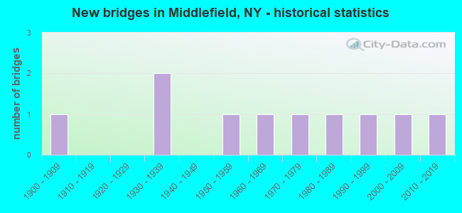
- New bridges - historical statistics
- 11900-1909
- 21930-1939
- 11950-1959
- 11960-1969
- 11970-1979
- 11980-1989
- 11990-1999
- 12000-2009
- 12010-2019

- Reconstructed bridges - Historical Statistics
- 11980-1989
- 01990-1999
- 22000-2009
- 12010-2019

- Bridge Condition - Deck
- 12.5%Excellent
- 25.0%Very good
- 37.5%Good
- 12.5%Satisfactory
- 12.5%Fair

- Bridge Condition - Superstructure
- 12.5%Very good
- 50.0%Good
- 25.0%Satisfactory
- 12.5%Fair

- Bridge Condition - Substructure
- 50.0%Good
- 25.0%Satisfactory
- 25.0%Fair

- Bridge Condition - Channel
- 10.0%Very good
- 10.0%Good
- 40.0%Satisfactory
- 40.0%Fair

- Bridge Condition - Culverts
- 50.0%Very good
- 50.0%Satisfactory
Find on map >> Show street view
Structure Number: 103889, Location: 3.3 MI SW JCT SH166 & SH1 (Lat: 42.709264, Lng: -74.818714), Route carried "on" structure: State highway 166, Year Built: 2012, Status: Open, Structure Length: 0.82m (2.69ft), Average Daily Traffic: 1,177 (year 2020), Truck Traffic: 8%, Average Future Daily Traffic: 1,227 (year 2040), Design Load: HL 93, Features Intersected: SHELLROCK CREEK
Minimum Vertical Clearance: 30+ m (98+ ft), Kilometerpoint: 18.310, Lanes on structure: 2, Base Highway Network: Yes, Owner: State Highway Agency, Approaching Roadway Width: 10.1m (33.1ft), Material/Design: Concrete, Design/Construction: Culvert, Number Of Spans In Main Unit: 1, Length of Maximum Span: 7.6m (24.9ft), Curb-To-Curb Width: 10.1m (33.1ft), Out-to-Out Width: 11.0m (36.1ft)
Condition: Channel: Good, Culverts: Very good, Operating Rating: 98.9 metric tons, Method Used To Determine Operating Rating: Load Factor (LF), Inventory Rating: 59.0 metric tons, Method Used To Determine Inventory Rating: Load Factor (LF), Structural Evaluation: Equal to present desirable criteria, Deck Geometry: Somewhat better than minimum adequacy, Waterway Adequacy: Equal to present minimum criteria, Approach Roadway Alignment: Equal to present desirable criteria, Length Of Structure Improvement: 0.82m (2.69ft), Designated Inspection Frequency: Every 24 months, Inspection Date: July 2020, Bridge Improvement Cost: $160,000, Roadway Improvement Cost: $94,000, Total Project Cost: $253,000 ( Estimate for 2021), Wearing Surface/Protective System: Wearing Surface: Bituminous
Find on map >> Show street view
Structure Number: 222769, Location: 1.0 MI E OF COOPERSTOWN (Lat: 42.694011, Lng: -74.901058), Route carried "on" structure: Other road , Year Built: 1900, Year Reconstructed: 2014, Status: Open, Structure Length: 1.43m (4.69ft), Average Daily Traffic: 230 (year 2017), Truck Traffic: 5%, Average Future Daily Traffic: 322 (year 2037), Features Intersected: RED CREEK, Facility Carried by Structure: PINK STREET
Minimum Vertical Clearance: 30+ m (98+ ft), Kilometerpoint: 0.225, Lanes on structure: 2, Owner: Town or Township Highway Agency, Approaching Roadway Width: 6.4m (21.0ft), Material/Design: Steel, Design/Construction: Stringer/Multi-beam, Number Of Spans In Main Unit: 1, Length of Maximum Span: 13.7m (44.9ft), Curb-To-Curb Width: 6.3m (20.7ft), Out-to-Out Width: 7.4m (24.3ft)
Condition: Deck: Good, Superstructure: Satisfactory, Substructure: Satisfactory, Channel: Satisfactory, Operating Rating: 41.7 metric tons, Method Used To Determine Operating Rating: Allowable Stress (AS), Inventory Rating: 24.5 metric tons, Method Used To Determine Inventory Rating: Allowable Stress (AS), Structural Evaluation: Equal to present minimum criteria, Deck Geometry: Meets minimum limits, Waterway Adequacy: Meets minimum limits, Approach Roadway Alignment: Somewhat better than minimum adequacy, Length Of Structure Improvement: 1.43m (4.69ft), Designated Inspection Frequency: Every 24 months, Inspection Date: June 2020, Bridge Improvement Cost: $387,000, Roadway Improvement Cost: $227,000, Total Project Cost: $613,000 ( Estimate for 2021), Deck Structure Type: Wood or Timber, Wearing Surface/Protective System: Wearing Surface: Bituminous
Find on map >> Show street view
Structure Number: 22277, Location: 1.5 MI NE OF COOPERSTOWN (Lat: 42.709325, Lng: -74.893175), Route carried "on" structure: Other road , Year Built: 1930, Year Reconstructed: 2007, Status: Posted for load, Structure Length: 0.94m (3.08ft), Average Daily Traffic: 209 (year 2017), Truck Traffic: 5%, Average Future Daily Traffic: 293 (year 2037), Features Intersected: RED CREEK, Facility Carried by Structure: HADE HOLLOW ROAD
Minimum Vertical Clearance: 30+ m (98+ ft), Kilometerpoint: 0.113, Lanes on structure: 2, Owner: Town or Township Highway Agency, Approaching Roadway Width: 7.3m (24.0ft), Material/Design: Steel, Design/Construction: Stringer/Multi-beam, Number Of Spans In Main Unit: 1, Length of Maximum Span: 8.5m (27.9ft), Curb-To-Curb Width: 6.5m (21.3ft), Out-to-Out Width: 7.1m (23.3ft)
Condition: Deck: Fair, Superstructure: Fair, Substructure: Fair, Channel: Fair, Operating Rating: 28.1 metric tons, Method Used To Determine Operating Rating: Load Factor (LF), Inventory Rating: 17.2 metric tons, Method Used To Determine Inventory Rating: Load Factor (LF), Structural Evaluation: Somewhat better than minimum adequacy, Deck Geometry: Meets minimum limits, Waterway Adequacy: Meets minimum limits, Approach Roadway Alignment: Equal to present minimum criteria, Bridge Posting: Required (Relationship of Operating Rating to Maximum Legal Load: > 39.9% below), Length Of Structure Improvement: 0.94m (3.08ft), Designated Inspection Frequency: Every 12 months, Inspection Date: June 2021, Bridge Improvement Cost: $269,000, Roadway Improvement Cost: $157,000, Total Project Cost: $426,000 ( Estimate for 2021), Deck Structure Type: Concrete Cast-file-Place, Wearing Surface/Protective System: Wearing Surface: Bituminous
Find on map >> Show street view
Structure Number: 222771, Location: 2.0 MI NE OF MIDDLEFIELD (Lat: 42.704275, Lng: -74.813211), Route carried "on" structure: Other road , Year Built: 1985, Year Reconstructed: 2021, Status: Posted for load, Structure Length: 1.52m (4.99ft), Average Daily Traffic: 230 (year 2017), Truck Traffic: 5%, Average Future Daily Traffic: 322 (year 2037), Features Intersected: CHERRY VALLEY CRK, Facility Carried by Structure: DUBBENS CROSS RD
Minimum Vertical Clearance: 30+ m (98+ ft), Kilometerpoint: 0.499, Lanes on structure: 1, Owner: Town or Township Highway Agency, Approaching Roadway Width: 6.1m (20.0ft), Material/Design: Steel, Design/Construction: Stringer/Multi-beam, Number Of Spans In Main Unit: 1, Length of Maximum Span: 14.6m (47.9ft), Curb-To-Curb Width: 5.2m (17.1ft), Out-to-Out Width: 6.2m (20.3ft)
Condition: Deck: Excellent, Superstructure: Good, Substructure: Good, Channel: Fair, Operating Rating: 29.9 metric tons, Method Used To Determine Operating Rating: Load Factor (LF), Inventory Rating: 17.2 metric tons, Method Used To Determine Inventory Rating: Load Factor (LF), Structural Evaluation: Somewhat better than minimum adequacy, Deck Geometry: High priority of replacement, Waterway Adequacy: Meets minimum limits, Approach Roadway Alignment: Equal to present desirable criteria, Bridge Posting: Required (Relationship of Operating Rating to Maximum Legal Load: > 39.9% below), Length Of Structure Improvement: 1.52m (4.99ft), Designated Inspection Frequency: Every 12 months, Inspection Date: July 2021, Bridge Improvement Cost: $297,000, Roadway Improvement Cost: $174,000, Total Project Cost: $471,000 ( Estimate for 2021), Deck Structure Type: Wood or Timber, Wearing Surface/Protective System: Wearing Surface: Bituminous
Find on map >> Show street view
Structure Number: 335424, Location: 2.2 MI NE COOPERSTOWN (Lat: 42.759783, Lng: -74.883678), Route carried "on" structure: County highway , Year Built: 2000, Status: Open, Structure Length: 2.71m (8.89ft), Average Daily Traffic: 1,092 (year 2018), Truck Traffic: 2%, Average Future Daily Traffic: 1,139 (year 2040), Design Load: HS 25 or greater, Features Intersected: TRIB TO OTSEGO LK, Facility Carried by Structure: COUNTY ROAD 31
Minimum Vertical Clearance: 30+ m (98+ ft), Kilometerpoint: 2.156, Lanes on structure: 2, Owner: County Highway Agency, Approaching Roadway Width: 8.5m (27.9ft), Material/Design: Steel, Design/Construction: Stringer/Multi-beam, Number Of Spans In Main Unit: 1, Length of Maximum Span: 25.9m (85.0ft), Curb-To-Curb Width: 8.6m (28.2ft), Out-to-Out Width: 9.5m (31.2ft)
Condition: Deck: Very good, Superstructure: Good, Substructure: Good, Channel: Very good, Operating Rating: 89.8 metric tons, Method Used To Determine Operating Rating: Load Factor (LF), Inventory Rating: 53.5 metric tons, Method Used To Determine Inventory Rating: Load Factor (LF), Structural Evaluation: Better than present minimum criteria, Deck Geometry: Somewhat better than minimum adequacy, Waterway Adequacy: Equal to present desirable criteria, Approach Roadway Alignment: Equal to present desirable criteria, Length Of Structure Improvement: 2.71m (8.89ft), Designated Inspection Frequency: Every 24 months, Inspection Date: June 2020, Bridge Improvement Cost: $659,000, Roadway Improvement Cost: $386,000, Total Project Cost: $1,045,000 ( Estimate for 2021), Deck Structure Type: Concrete Cast-file-Place, Wearing Surface/Protective System: Wearing Surface: Integral Concrete, Deck Protection: Epoxy Coated Reinforcing
Find on map >> Show street view
Structure Number: 335433, Location: 1.0 MI EAST OF MILFORD (Lat: 42.593453, Lng: -74.927525), Route carried "on" structure: County highway , Year Built: 1999, Status: Open, Structure Length: 3.29m (10.79ft), Average Daily Traffic: 995 (year 2018), Truck Traffic: 11%, Average Future Daily Traffic: 1,037 (year 2040), Features Intersected: CHERRY VALLEY CREEK, Facility Carried by Structure: COUNTY RD 35B
Minimum Vertical Clearance: 30+ m (98+ ft), Kilometerpoint: 0.016, Lanes on structure: 2, Owner: County Highway Agency, Approaching Roadway Width: 8.8m (28.9ft), Material/Design: Prestressed concrete, Design/Construction: Stringer/Multi-beam, Number Of Spans In Main Unit: 1, Length of Maximum Span: 31.4m (103.0ft), Curb-To-Curb Width: 9.0m (29.5ft), Out-to-Out Width: 10.0m (32.8ft)
Condition: Deck: Good, Superstructure: Very good, Substructure: Good, Channel: Satisfactory, Operating Rating: 78.0 metric tons, Method Used To Determine Operating Rating: Load Factor (LF), Inventory Rating: 46.3 metric tons, Method Used To Determine Inventory Rating: Load Factor (LF), Structural Evaluation: Better than present minimum criteria, Deck Geometry: Somewhat better than minimum adequacy, Waterway Adequacy: Equal to present minimum criteria, Approach Roadway Alignment: Equal to present desirable criteria, Length Of Structure Improvement: 3.29m (10.79ft), Designated Inspection Frequency: Every 24 months, Inspection Date: September 2021, Bridge Improvement Cost: $809,000, Roadway Improvement Cost: $474,000, Total Project Cost: $1,283,000 ( Estimate for 2021), Deck Structure Type: Concrete Cast-file-Place, Wearing Surface/Protective System: Wearing Surface: Integral Concrete, Deck Protection: Epoxy Coated Reinforcing
Find on map >> Show street view
Structure Number: 335435, Location: HAMLET OF MIDDLEFIELD (Lat: 42.689142, Lng: -74.842450), Route carried "on" structure: County highway , Year Built: 1975, Year Reconstructed: 2018, Status: Open, Structure Length: 3.08m (10.10ft), Average Daily Traffic: 760 (year 2017), Truck Traffic: 5%, Average Future Daily Traffic: 1,064 (year 2037), Design Load: H 20, Features Intersected: CHERRY VALLEY CRK, Facility Carried by Structure: COUNTY ROAD 35
Minimum Vertical Clearance: 30+ m (98+ ft), Kilometerpoint: 27.401, Lanes on structure: 2, Owner: County Highway Agency, Approaching Roadway Width: 7.9m (25.9ft), Skew: 3 degrees, Material/Design: Steel, Design/Construction: Stringer/Multi-beam, Number Of Spans In Main Unit: 1, Length of Maximum Span: 29.5m (96.8ft), Curb-To-Curb Width: 7.3m (24.0ft), Out-to-Out Width: 8.2m (26.9ft)
Condition: Deck: Very good, Superstructure: Good, Substructure: Good, Channel: Fair, Operating Rating: 88.9 metric tons, Method Used To Determine Operating Rating: Load Factor (LF), Inventory Rating: 53.5 metric tons, Method Used To Determine Inventory Rating: Load Factor (LF), Structural Evaluation: Better than present minimum criteria, Deck Geometry: Meets minimum limits, Waterway Adequacy: Meets minimum limits, Approach Roadway Alignment: Equal to present desirable criteria, Length Of Structure Improvement: 3.07m (10.07ft), Designated Inspection Frequency: Every 24 months, Inspection Date: April 2021, Bridge Improvement Cost: $869,000, Roadway Improvement Cost: $509,000, Total Project Cost: $1,378,000 ( Estimate for 2021), Deck Structure Type: Concrete Cast-file-Place, Wearing Surface/Protective System: Wearing Surface: Integral Concrete, Deck Protection: Epoxy Coated Reinforcing
Find on map >> Show street view
Structure Number: 335436, Location: 1 MILE WEST OF WESTVILLE (Lat: 42.647589, Lng: -74.876314), Route carried "on" structure: Other road , Year Built: 1961, Status: Open, Structure Length: 1.86m (6.10ft), Average Daily Traffic: 398 (year 2017), Truck Traffic: 5%, Average Future Daily Traffic: 557 (year 2037), Features Intersected: CHERRY VALLEY CREEK, Facility Carried by Structure: NORTON CROSS ROAD
Minimum Vertical Clearance: 30+ m (98+ ft), Kilometerpoint: 1.191, Lanes on structure: 2, Owner: County Highway Agency, Approaching Roadway Width: 5.8m (19.0ft), Skew: 1 degrees, Material/Design: Steel, Design/Construction: Culvert, Number Of Spans In Main Unit: 3, Length of Maximum Span: 5.5m (18.0ft)
Condition: Channel: Satisfactory, Culverts: Satisfactory, Operating Rating: 76.5 metric tons, Method Used To Determine Operating Rating: Field evaluation and documented engineering judgment, Inventory Rating: 32.7 metric tons, Method Used To Determine Inventory Rating: Field evaluation and documented engineering judgment, Structural Evaluation: Equal to present minimum criteria, Waterway Adequacy: Equal to present desirable criteria, Approach Roadway Alignment: Meets minimum limits, Length Of Structure Improvement: 1.85m (6.07ft), Designated Inspection Frequency: Every 24 months, Inspection Date: May 2020, Bridge Improvement Cost: $213,000, Roadway Improvement Cost: $125,000, Total Project Cost: $338,000 ( Estimate for 2021), Wearing Surface/Protective System: Wearing Surface: Bituminous
Find on map >> Show street view
Structure Number: 335445, Location: .5 MILE NW OF WESTVILLE (Lat: 42.632575, Lng: -74.882644), Route carried "on" structure: County highway , Year Built: 1958, Status: Posted for load, Structure Length: 1.83m (6.00ft), Average Daily Traffic: 369 (year 2017), Truck Traffic: 8%, Average Future Daily Traffic: 517 (year 2037), Features Intersected: CHERRY VALLEY CREEK, Facility Carried by Structure: COUNTY ROAD 43
Minimum Vertical Clearance: 30+ m (98+ ft), Kilometerpoint: 0.418, Lanes on structure: 2, Owner: County Highway Agency, Approaching Roadway Width: 7.6m (24.9ft), Skew: 1 degrees, Material/Design: Steel, Design/Construction: Stringer/Multi-beam, Number Of Spans In Main Unit: 1, Length of Maximum Span: 17.9m (58.7ft), Curb-To-Curb Width: 7.9m (25.9ft), Out-to-Out Width: 8.5m (27.9ft)
Condition: Deck: Satisfactory, Superstructure: Satisfactory, Substructure: Satisfactory, Channel: Satisfactory, Operating Rating: 32.7 metric tons, Method Used To Determine Operating Rating: Load Factor (LF), Inventory Rating: 16.3 metric tons, Method Used To Determine Inventory Rating: Load Factor (LF), Structural Evaluation: Somewhat better than minimum adequacy, Deck Geometry: Somewhat better than minimum adequacy, Waterway Adequacy: Meets minimum limits, Approach Roadway Alignment: Equal to present minimum criteria, Bridge Posting: Required (Relationship of Operating Rating to Maximum Legal Load: > 39.9% below), Length Of Structure Improvement: 1.82m (5.97ft), Designated Inspection Frequency: Every 12 months, Inspection Date: May 2021, Bridge Improvement Cost: $493,000, Roadway Improvement Cost: $289,000, Total Project Cost: $782,000 ( Estimate for 2021), Deck Structure Type: Concrete Cast-file-Place, Wearing Surface/Protective System: Wearing Surface: Bituminous
Find on map >> Show street view
Structure Number: 335456, Location: 0.5 MI SE COOPERSTOWN (Lat: 42.686356, Lng: -74.917892), Route carried "on" structure: County highway , Year Built: 1933, Year Reconstructed: 1992, Status: Open, Structure Length: 2.56m (8.40ft), Average Daily Traffic: 3,093 (year 2020), Truck Traffic: 5%, Average Future Daily Traffic: 3,226 (year 2040), Design Load: HS 20, Features Intersected: RED CREEK, Facility Carried by Structure: CR 52 & CR 33
Minimum Vertical Clearance: 30+ m (98+ ft), Kilometerpoint: 12.019, Lanes on structure: 2, Owner: County Highway Agency, Approaching Roadway Width: 5.5m (18.0ft), Material/Design: Steel, Design/Construction: Stringer/Multi-beam, Number Of Spans In Main Unit: 1, Length of Maximum Span: 24.6m (80.7ft), Curb-To-Curb Width: 8.5m (27.9ft), Out-to-Out Width: 9.1m (29.9ft)
Condition: Deck: Good, Superstructure: Good, Substructure: Fair, Channel: Fair, Operating Rating: 68.0 metric tons, Method Used To Determine Operating Rating: Load Factor (LF), Inventory Rating: 37.2 metric tons, Method Used To Determine Inventory Rating: Load Factor (LF), Structural Evaluation: Somewhat better than minimum adequacy, Deck Geometry: Meets minimum limits, Waterway Adequacy: Equal to present desirable criteria, Approach Roadway Alignment: Meets minimum limits, Length Of Structure Improvement: 2.56m (8.40ft), Designated Inspection Frequency: Every 24 months, Inspection Date: March 2021, Bridge Improvement Cost: $752,000, Roadway Improvement Cost: $441,000, Total Project Cost: $1,193,000 ( Estimate for 2021), Deck Structure Type: Concrete Cast-file-Place, Wearing Surface/Protective System: Wearing Surface: Bituminous, Membrane: Other, Deck Protection: Epoxy Coated Reinforcing