Bridge Statistics for Middletown, Kentucky (KY)
Condition, Traffic, Stress, Structural Evaluation, Project Costs
- National Bridge Inventory (NBI) Statistics
- 15Number of bridges
- 164ft / 50.3mTotal length
- $4,274,000Total costs
- 490,550Total average daily traffic
- 62,959Total average daily truck traffic
- National Bridge Inventory (NBI) Registered Bridges for Middletown
- No street view available for this location
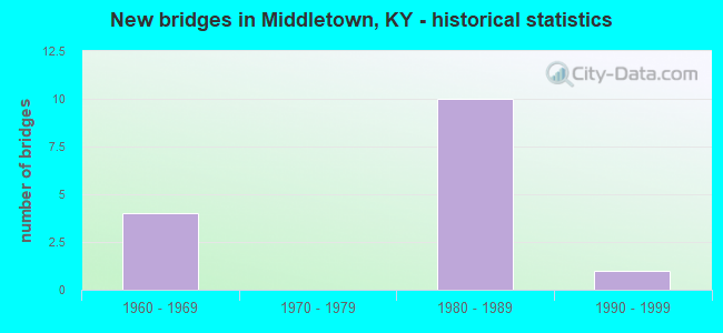
- New bridges - historical statistics
- 41960-1969
- 101980-1989
- 11990-1999


- Bridge Condition - Deck
- 25.0%Good
- 75.0%Satisfactory

- Bridge Condition - Superstructure
- 12.5%Good
- 87.5%Satisfactory

- Bridge Condition - Substructure
- 25.0%Good
- 75.0%Satisfactory

- Bridge Condition - Channel
- 50.0%Good
- 50.0%Satisfactory
Find on map >> Show street view
Structure Number: 56B00090L, Location: 1.3 MI S OF US 60 NTRCH (Lat: 38.222778, Lng: -85.505833), Route carried "on" structure: Interstate 265, Year Built: 1961, Status: Open, Structure Length: 8.38m (27.49ft), Average Daily Traffic: 35,673 (year 2019), Truck Traffic: 9%, Average Future Daily Traffic: 38,170 (year 2039), Design Load: HS 20, Features Intersected: I-64
Minimum Vertical Clearance: 30+ m (98+ ft), Kilometerpoint: 40.953, Lanes on structure: 2, Lanes under structure: 6, Base Highway Network: Yes, Owner: State Highway Agency, Approaching Roadway Width: 12.8m (42.0ft), Material/Design: Concrete continuous, Design/Construction: Tee Beam, Number Of Spans In Main Unit: 4, Length of Maximum Span: 24.4m (80.1ft), Curb-To-Curb Width: 12.8m (42.0ft), Out-to-Out Width: 15.1m (49.5ft)
Condition: Deck: Satisfactory, Superstructure: Satisfactory, Substructure: Satisfactory, Operating Rating: 73.5 metric tons, Method Used To Determine Operating Rating: Load Factor (LF), Inventory Rating: 44.5 metric tons, Method Used To Determine Inventory Rating: Load Factor (LF), Structural Evaluation: Equal to present minimum criteria, Deck Geometry: Equal to present desirable criteria, Underclear: Meets minimum limits, Approach Roadway Alignment: Equal to present desirable criteria, Designated Inspection Frequency: Every 24 months, Inspection Date: May 2021, Deck Structure Type: Concrete Cast-file-Place, Wearing Surface/Protective System: Wearing Surface: Latex Concrete
Find on map >> Show street view
Structure Number: 56B00090R, Location: 1.3 MI S OF US 60 NTRCH (Lat: 38.222778, Lng: -85.505556), Route carried "on" structure: Interstate 265, Year Built: 1961, Status: Open, Structure Length: 8.38m (27.49ft), Average Daily Traffic: 40,309 (year 2020), Truck Traffic: 11%, Average Future Daily Traffic: 43,131 (year 2040), Design Load: HS 20, Features Intersected: I-64
Minimum Vertical Clearance: 30+ m (98+ ft), Kilometerpoint: 41.008, Lanes on structure: 2, Lanes under structure: 6, Base Highway Network: Yes, Owner: State Highway Agency, Approaching Roadway Width: 11.6m (38.1ft), Material/Design: Concrete continuous, Design/Construction: Tee Beam, Number Of Spans In Main Unit: 4, Length of Maximum Span: 24.4m (80.1ft), Curb-To-Curb Width: 12.8m (42.0ft), Out-to-Out Width: 15.1m (49.5ft)
Condition: Deck: Satisfactory, Superstructure: Satisfactory, Substructure: Satisfactory, Operating Rating: 73.5 metric tons, Method Used To Determine Operating Rating: Load Factor (LF), Inventory Rating: 44.5 metric tons, Method Used To Determine Inventory Rating: Load Factor (LF), Structural Evaluation: Equal to present minimum criteria, Deck Geometry: Equal to present desirable criteria, Underclear: Somewhat better than minimum adequacy, Approach Roadway Alignment: Equal to present desirable criteria, Designated Inspection Frequency: Every 24 months, Inspection Date: May 2021, Deck Structure Type: Concrete Cast-file-Place, Wearing Surface/Protective System: Wearing Surface: Latex Concrete
Find on map >> Show street view
Structure Number: 56B00334L, Location: 1.3 MI N OF I-64 NTRCH (Lat: 38.241944, Lng: -85.503889), Route carried "on" structure: Interstate 265, Year Built: 1984, Status: Open, Structure Length: 6.23m (20.44ft), Average Daily Traffic: 40,309 (year 2020), Truck Traffic: 11%, Average Future Daily Traffic: 43,131 (year 2040), Design Load: HS 20, Features Intersected: US 60
Minimum Vertical Clearance: 30+ m (98+ ft), Kilometerpoint: 43.098, Lanes on structure: 2, Lanes under structure: 4, Base Highway Network: Yes, Owner: State Highway Agency, Approaching Roadway Width: 12.2m (40.0ft), Material/Design: Prestressed concrete continuous, Design/Construction: Stringer/Multi-beam, Number Of Spans In Main Unit: 3, Length of Maximum Span: 31.2m (102.4ft), Curb-To-Curb Width: 12.2m (40.0ft), Out-to-Out Width: 13.2m (43.3ft)
Condition: Deck: Satisfactory, Superstructure: Satisfactory, Substructure: Satisfactory, Operating Rating: 95.1 metric tons, Method Used To Determine Operating Rating: Load Factor (LF), Inventory Rating: 57.1 metric tons, Method Used To Determine Inventory Rating: Load Factor (LF), Structural Evaluation: Equal to present minimum criteria, Deck Geometry: Better than present minimum criteria, Underclear: High priority of corrective action, Approach Roadway Alignment: Equal to present desirable criteria, Length Of Structure Improvement: 0.62m (2.03ft), Designated Inspection Frequency: Every 24 months, Inspection Date: May 2021, Bridge Improvement Cost: $1,104,000, Total Project Cost: $1,104,000, Deck Structure Type: Concrete Cast-file-Place, Wearing Surface/Protective System: Wearing Surface: Epoxy Overlay, Deck Protection: Epoxy Coated Reinforcing
Find on map >> Show street view
Structure Number: 56B00334R, Location: 1.3 MI N OF I-64 NTRCH (Lat: 38.241944, Lng: -85.503611), Route carried "on" structure: Interstate 265, Year Built: 1984, Status: Open, Structure Length: 6.23m (20.44ft), Average Daily Traffic: 32,635 (year 2020), Truck Traffic: 13%, Average Future Daily Traffic: 34,919 (year 2040), Design Load: HS 20, Features Intersected: US 60
Minimum Vertical Clearance: 30+ m (98+ ft), Kilometerpoint: 43.153, Lanes on structure: 2, Lanes under structure: 4, Base Highway Network: Yes, Owner: State Highway Agency, Approaching Roadway Width: 12.2m (40.0ft), Material/Design: Prestressed concrete continuous, Design/Construction: Stringer/Multi-beam, Number Of Spans In Main Unit: 3, Length of Maximum Span: 31.2m (102.4ft), Curb-To-Curb Width: 12.2m (40.0ft), Out-to-Out Width: 13.2m (43.3ft)
Condition: Deck: Satisfactory, Superstructure: Satisfactory, Substructure: Satisfactory, Operating Rating: 95.1 metric tons, Method Used To Determine Operating Rating: Load Factor (LF), Inventory Rating: 57.1 metric tons, Method Used To Determine Inventory Rating: Load Factor (LF), Structural Evaluation: Equal to present minimum criteria, Deck Geometry: Better than present minimum criteria, Underclear: High priority of corrective action, Approach Roadway Alignment: Equal to present desirable criteria, Length Of Structure Improvement: 0.62m (2.03ft), Designated Inspection Frequency: Every 24 months, Inspection Date: May 2021, Bridge Improvement Cost: $1,104,000, Total Project Cost: $1,104,000, Deck Structure Type: Concrete Cast-file-Place, Wearing Surface/Protective System: Wearing Surface: Epoxy Overlay, Deck Protection: Epoxy Coated Reinforcing
Find on map >> Show street view
Structure Number: 56B00335N, Location: 0.9 MI N OF US 60 NTRCH (Lat: 38.254722, Lng: -85.502500), Route carried "on" structure: Interstate 265, Year Built: 1984, Status: Open, Structure Length: 1.13m (3.71ft), Average Daily Traffic: 65,270 (year 2020), Truck Traffic: 13%, Average Future Daily Traffic: 69,838 (year 2040), Features Intersected: CHENOWETH RUN
Minimum Vertical Clearance: 30+ m (98+ ft), Kilometerpoint: 44.585, Lanes on structure: 4, Base Highway Network: Yes, Owner: State Highway Agency, Approaching Roadway Width: 24.4m (80.1ft), Skew: 10 degrees, Material/Design: Concrete, Design/Construction: Culvert, Number Of Spans In Main Unit: 2, Length of Maximum Span: 5.5m (18.0ft)
Condition: Channel: Satisfactory, Culverts: Satisfactory, Operating Rating: 54.4 metric tons, Method Used To Determine Operating Rating: Field evaluation and documented engineering judgment, Inventory Rating: 39.9 metric tons, Method Used To Determine Inventory Rating: Field evaluation and documented engineering judgment, Structural Evaluation: Equal to present minimum criteria, Waterway Adequacy: Equal to present desirable criteria, Approach Roadway Alignment: Equal to present desirable criteria, Designated Inspection Frequency: Every 24 months, Inspection Date: May 2021
Find on map >> Show street view
Structure Number: 56B00336L, Location: 1.0 MI N OF US 60 NTRCH (Lat: 38.255833, Lng: -85.502500), Route carried "on" structure: Interstate 265, Year Built: 1984, Status: Open, Structure Length: 5.82m (19.09ft), Average Daily Traffic: 32,635 (year 2020), Truck Traffic: 13%, Average Future Daily Traffic: 34,919 (year 2040), Design Load: HS 20, Features Intersected: AIKEN RD
Minimum Vertical Clearance: 30+ m (98+ ft), Kilometerpoint: 44.635, Lanes on structure: 2, Lanes under structure: 2, Base Highway Network: Yes, Owner: State Highway Agency, Approaching Roadway Width: 12.2m (40.0ft), Skew: 2 degrees, Material/Design: Prestressed concrete continuous, Design/Construction: Stringer/Multi-beam, Number Of Spans In Main Unit: 3, Length of Maximum Span: 21.3m (69.9ft), Curb-To-Curb Width: 12.2m (40.0ft), Out-to-Out Width: 13.2m (43.3ft)
Condition: Deck: Satisfactory, Superstructure: Satisfactory, Substructure: Good, Operating Rating: 79.2 metric tons, Method Used To Determine Operating Rating: Load Factor (LF), Inventory Rating: 47.5 metric tons, Method Used To Determine Inventory Rating: Load Factor (LF), Structural Evaluation: Equal to present minimum criteria, Deck Geometry: Better than present minimum criteria, Underclear: Superior to present desirable criteria, Approach Roadway Alignment: Equal to present desirable criteria, Length Of Structure Improvement: 0.58m (1.90ft), Designated Inspection Frequency: Every 24 months, Inspection Date: May 2021, Bridge Improvement Cost: $1,034,000, Total Project Cost: $1,033,000, Deck Structure Type: Concrete Cast-file-Place, Wearing Surface/Protective System: Wearing Surface: Epoxy Overlay, Deck Protection: Epoxy Coated Reinforcing
Find on map >> Show street view
Structure Number: 56B00336R, Location: 1.0 MI N OF US 60 NTRCH (Lat: 38.255833, Lng: -85.502222), Route carried "on" structure: Interstate 265, Year Built: 1984, Status: Open, Structure Length: 5.82m (19.09ft), Average Daily Traffic: 32,635 (year 2020), Truck Traffic: 13%, Average Future Daily Traffic: 34,919 (year 2040), Design Load: HS 20, Features Intersected: AIKEN RD
Minimum Vertical Clearance: 30+ m (98+ ft), Kilometerpoint: 44.701, Lanes on structure: 2, Lanes under structure: 2, Base Highway Network: Yes, Owner: State Highway Agency, Approaching Roadway Width: 12.2m (40.0ft), Skew: 2 degrees, Material/Design: Prestressed concrete continuous, Design/Construction: Stringer/Multi-beam, Number Of Spans In Main Unit: 3, Length of Maximum Span: 21.3m (69.9ft), Curb-To-Curb Width: 12.2m (40.0ft), Out-to-Out Width: 13.2m (43.3ft)
Condition: Deck: Good, Superstructure: Satisfactory, Substructure: Good, Operating Rating: 79.2 metric tons, Method Used To Determine Operating Rating: Load Factor (LF), Inventory Rating: 47.5 metric tons, Method Used To Determine Inventory Rating: Load Factor (LF), Structural Evaluation: Equal to present minimum criteria, Deck Geometry: Better than present minimum criteria, Underclear: Superior to present desirable criteria, Approach Roadway Alignment: Equal to present desirable criteria, Length Of Structure Improvement: 0.58m (1.90ft), Designated Inspection Frequency: Every 24 months, Inspection Date: May 2021, Bridge Improvement Cost: $1,034,000, Total Project Cost: $1,033,000, Deck Structure Type: Concrete Cast-file-Place, Wearing Surface/Protective System: Wearing Surface: Epoxy Overlay, Deck Protection: Epoxy Coated Reinforcing
Find on map >> Show street view
Structure Number: 56B00337L, Location: 2.4 MI N OF I-64 NTRCH (Lat: 38.258056, Lng: -85.502222), Route carried "on" structure: Interstate 265, Year Built: 1984, Status: Open, Structure Length: 7.21m (23.65ft), Average Daily Traffic: 32,635 (year 2020), Truck Traffic: 13%, Average Future Daily Traffic: 34,919 (year 2040), Design Load: HS 20, Features Intersected: RJ CORMAN RAILROAD
Minimum Vertical Clearance: 30+ m (98+ ft), Kilometerpoint: 44.891, Lanes on structure: 2, Base Highway Network: Yes, Owner: State Highway Agency, Approaching Roadway Width: 12.2m (40.0ft), Skew: 4 degrees, Material/Design: Prestressed concrete continuous, Design/Construction: Stringer/Multi-beam, Number Of Spans In Main Unit: 3, Length of Maximum Span: 27.4m (89.9ft), Curb-To-Curb Width: 12.2m (40.0ft), Out-to-Out Width: 13.2m (43.3ft)
Condition: Deck: Satisfactory, Superstructure: Satisfactory, Substructure: Satisfactory, Operating Rating: 99.8 metric tons, Method Used To Determine Operating Rating: Load Factor (LF), Inventory Rating: 64.0 metric tons, Method Used To Determine Inventory Rating: Load Factor (LF), Structural Evaluation: Equal to present minimum criteria, Deck Geometry: Better than present minimum criteria, Underclear: Superior to present desirable criteria, Approach Roadway Alignment: Equal to present desirable criteria, Designated Inspection Frequency: Every 24 months, Inspection Date: May 2021, Deck Structure Type: Concrete Cast-file-Place, Wearing Surface/Protective System: Wearing Surface: Epoxy Overlay, Deck Protection: Epoxy Coated Reinforcing
Find on map >> Show street view
Structure Number: 56C00189N, Location: 0.55 MI E OF N ENG STA RD (Lat: 38.255556, Lng: -85.503611), Route carried "on" structure: County highway 1001, Year Built: 1993, Status: Open, Structure Length: 1.10m (3.61ft), Average Daily Traffic: 3,747 (year 2018), Average Future Daily Traffic: 3,484 (year 2038), Design Load: HS 25 or greater, Features Intersected: CHENOWETH RUN, Facility Carried by Structure: AIKEN RD
Minimum Vertical Clearance: 30+ m (98+ ft), Kilometerpoint: 1.780, Lanes on structure: 2, Owner: County Highway Agency, Approaching Roadway Width: 6.4m (21.0ft), Skew: 1 degrees, Material/Design: Prestressed concrete, Design/Construction: Box Beam or Girders - Multiple, Number Of Spans In Main Unit: 1, Length of Maximum Span: 10.4m (34.1ft), Curb-To-Curb Width: 8.5m (27.9ft), Out-to-Out Width: 9.8m (32.2ft)
Condition: Deck: Good, Superstructure: Good, Substructure: Satisfactory, Channel: Good, Operating Rating: 58.2 metric tons, Method Used To Determine Operating Rating: Load Factor (LF), Inventory Rating: 34.9 metric tons, Method Used To Determine Inventory Rating: Load Factor (LF), Structural Evaluation: Equal to present minimum criteria, Deck Geometry: Meets minimum limits, Waterway Adequacy: Equal to present desirable criteria, Approach Roadway Alignment: Equal to present desirable criteria, Designated Inspection Frequency: Every 24 months, Inspection Date: November 2021, Deck Structure Type: Concrete Precast Panels, Wearing Surface/Protective System: Wearing Surface: Bituminous, Membrane: Preformed Fabric, Deck Protection: Epoxy Coated Reinforcing
Find on map >> Show street view
Structure Number: 56B00090L, Location: 1.3 MI S OF US 60 NTRCH (Lat: 38.222778, Lng: -85.505833), Route carried "under" structure: Interstate 64, Year Built: 1961, Structure Length: 0. m, Average Daily Traffic: 50,196 (year 2020), Truck Traffic: 24%, Features Intersected: I-64, Facility Carried by Structure: I-265 SB
Minimum Vertical Clearance: 4.67m (15.32ft), Kilometerpoint: 30.516, Lanes on structure: 2, Lanes under structure: 6, Material/Design: Concrete continuous, Design/Construction: Tee Beam, Length of Maximum Span: 24.4m (80.1ft)
Find on map >> Show street view
Structure Number: 56B00090R, Location: 1.3 MI S OF US 60 NTRCH (Lat: 38.222778, Lng: -85.505556), Route carried "under" structure: Interstate 64, Year Built: 1961, Structure Length: 0. m, Average Daily Traffic: 50,196 (year 2020), Truck Traffic: 24%, Features Intersected: I-64, Facility Carried by Structure: I-265 NB
Minimum Vertical Clearance: 4.95m (16.24ft), Kilometerpoint: 30.537, Lanes on structure: 2, Lanes under structure: 6, Material/Design: Concrete continuous, Design/Construction: Tee Beam, Length of Maximum Span: 24.4m (80.1ft)
Find on map >> Show street view
Structure Number: 56B00334L, Location: 1.3 MI N OF I-64 NTRCH (Lat: 38.241944, Lng: -85.503889), Route carried "under" structure: US 60, Year Built: 1984, Structure Length: 0. m, Average Daily Traffic: 33,408 (year 2018), Truck Traffic: 2%, Features Intersected: US 60, Facility Carried by Structure: I-265 SB
Minimum Vertical Clearance: 5.36m (17.59ft), Kilometerpoint: 19.323, Lanes on structure: 2, Lanes under structure: 4, Material/Design: Prestressed concrete continuous, Design/Construction: Stringer/Multi-beam, Length of Maximum Span: 31.2m (102.4ft)
Find on map >> Show street view
Structure Number: 56B00334R, Location: 1.3 MI N OF I-64 NTRCH (Lat: 38.241944, Lng: -85.503611), Route carried "under" structure: US 60, Year Built: 1984, Structure Length: 0. m, Average Daily Traffic: 33,408 (year 2018), Truck Traffic: 2%, Features Intersected: US 60, Facility Carried by Structure: I-265 NB
Minimum Vertical Clearance: 6.43m (21.10ft), Kilometerpoint: 19.339, Lanes on structure: 2, Lanes under structure: 4, Material/Design: Prestressed concrete continuous, Design/Construction: Stringer/Multi-beam, Length of Maximum Span: 31.2m (102.4ft)
Find on map >> Show street view
Structure Number: 56B00336L, Location: 1.0 MI N OF US 60 NTRCH (Lat: 38.255833, Lng: -85.502500), Route carried "under" structure: County highway 1001, Year Built: 1984, Structure Length: 0. m, Average Daily Traffic: 3,747 (year 2018), Features Intersected: AIKEN RD, Facility Carried by Structure: I-265 SB
Minimum Vertical Clearance: 8.59m (28.18ft), Kilometerpoint: 1.885, Lanes on structure: 2, Lanes under structure: 2, Material/Design: Prestressed concrete continuous, Design/Construction: Stringer/Multi-beam, Length of Maximum Span: 21.3m (69.9ft)
Find on map >> Show street view
Structure Number: 56B00336R, Location: 1.0 MI N OF US 60 NTRCH (Lat: 38.255833, Lng: -85.502222), Route carried "under" structure: County highway 1001, Year Built: 1984, Structure Length: 0. m, Average Daily Traffic: 3,747 (year 2018), Features Intersected: AIKEN RD, Facility Carried by Structure: I-265 NB
Minimum Vertical Clearance: 8.15m (26.74ft), Kilometerpoint: 1.915, Lanes on structure: 2, Lanes under structure: 2, Material/Design: Prestressed concrete continuous, Design/Construction: Stringer/Multi-beam, Length of Maximum Span: 21.3m (69.9ft)