Bridge Statistics for Midland City, Alabama (AL)
Condition, Traffic, Stress, Structural Evaluation, Project Costs
- National Bridge Inventory (NBI) Statistics
- 12Number of bridges
- 141ft / 43.2mTotal length
- $12,415,000Total costs
- 63,939Total average daily traffic
- 8,516Total average daily truck traffic
- National Bridge Inventory (NBI) Registered Bridges for Midland City
- No street view available for this location
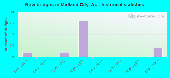
- New bridges - historical statistics
- 11920-1929
- 11940-1949
- 81950-1959
- 21990-1999


- Bridge Condition - Deck
- 25.0%Good
- 75.0%Satisfactory

- Bridge Condition - Superstructure
- 50.0%Good
- 50.0%Satisfactory

- Bridge Condition - Substructure
- 50.0%Good
- 50.0%Satisfactory

- Bridge Condition - Channel
- 37.5%Good
- 37.5%Satisfactory
- 25.0%Fair

- Bridge Condition - Culverts
- 16.7%Good
- 66.7%Satisfactory
- 16.7%Fair
Find on map >> Show street view
Structure Number: 663, Location: 2.2 MI E CO 9 (Lat: 30.406558, Lng: -87.774269), Route carried "on" structure: US 98, Year Built: 1929, Status: Open, Structure Length: 0.76m (2.49ft), Average Daily Traffic: 10,420 (year 2019), Truck Traffic: 6%, Average Future Daily Traffic: 15,630 (year 2039), Design Load: H 15, Features Intersected: BRANCH TO MAGNOLIA RIVER
Minimum Vertical Clearance: 30+ m (98+ ft), Kilometerpoint: 95.420, Lanes on structure: 2, Owner: State Highway Agency, Approaching Roadway Width: 8.6m (28.2ft), Material/Design: Steel, Design/Construction: Culvert, Number Of Spans In Main Unit: 2, Length of Maximum Span: 3.0m (9.8ft)
Condition: Channel: Satisfactory, Culverts: Satisfactory, Operating Rating: 73.1 metric tons, Method Used To Determine Operating Rating: Load Factor (LF), Inventory Rating: 70.2 metric tons, Method Used To Determine Inventory Rating: Load Factor (LF), Structural Evaluation: Equal to present minimum criteria, Waterway Adequacy: Equal to present minimum criteria, Approach Roadway Alignment: Equal to present desirable criteria, Length Of Structure Improvement: 1.41m (4.63ft), Designated Inspection Frequency: Every 24 months, Inspection Date: November 2020, Bridge Improvement Cost: $596,000, Roadway Improvement Cost: $60,000, Total Project Cost: $656,000 ( Estimate for 2022)
Find on map >> Show street view
Structure Number: 3474, Location: SEC-12 T-4-N R-25-E (Lat: 31.340861, Lng: -85.487350), Route carried "on" structure: County highway 67, Year Built: 1949, Status: Open, Structure Length: 1.31m (4.30ft), Average Daily Traffic: 520 (year 2007), Truck Traffic: 6%, Average Future Daily Traffic: 773 (year 2034), Design Load: H 15, Features Intersected: KELLY CREEK
Minimum Vertical Clearance: 30+ m (98+ ft), Kilometerpoint: 0.000, Lanes on structure: 2, Owner: County Highway Agency, Approaching Roadway Width: 9.1m (29.9ft), Material/Design: Concrete, Design/Construction: Culvert, Number Of Spans In Main Unit: 4, Length of Maximum Span: 3.0m (9.8ft)
Condition: Channel: Satisfactory, Culverts: Satisfactory, Operating Rating: 39.4 metric tons, Method Used To Determine Operating Rating: Load Factor (LF), Inventory Rating: 23.6 metric tons, Method Used To Determine Inventory Rating: Load Factor (LF), Structural Evaluation: Equal to present minimum criteria, Waterway Adequacy: Equal to present minimum criteria, Approach Roadway Alignment: Better than present minimum criteria, Length Of Structure Improvement: 1.98m (6.50ft), Designated Inspection Frequency: Every 24 months, Inspection Date: March 2021, Bridge Improvement Cost: $367,000, Roadway Improvement Cost: $37,000, Total Project Cost: $404,000 ( Estimate for 2022)
Find on map >> Show street view
Structure Number: 3814, Location: SEC-31 T-5-N R-26-E (Lat: 31.372969, Lng: -85.477050), Route carried "on" structure: County highway 67, Year Built: 1950, Status: Posted for load, Structure Length: 18.07m (59.28ft), Average Daily Traffic: 520 (year 2007), Truck Traffic: 11%, Average Future Daily Traffic: 773 (year 2034), Features Intersected: EAST CHOCTAWHATCHEE R
Minimum Vertical Clearance: 7.56m (24.80ft), Kilometerpoint: 0.000, Lanes on structure: 2, Owner: County Highway Agency, Approaching Roadway Width: 9.1m (29.9ft), Material/Design: Steel, Design/Construction: Stringer/Multi-beam, Number Of Spans In Main Unit: 13, Length of Maximum Span: 18.3m (60.0ft), Curb-To-Curb Width: 6.7m (22.0ft), Out-to-Out Width: 7.6m (24.9ft)
Condition: Deck: Satisfactory, Superstructure: Satisfactory, Substructure: Satisfactory, Channel: Good, Operating Rating: 25.1 metric tons, Method Used To Determine Operating Rating: Load Factor (LF), Inventory Rating: 15.1 metric tons, Method Used To Determine Inventory Rating: Load Factor (LF), Structural Evaluation: Meets minimum limits, Deck Geometry: Meets minimum limits, Waterway Adequacy: Better than present minimum criteria, Approach Roadway Alignment: Better than present minimum criteria, Bridge Posting: Required (Relationship of Operating Rating to Maximum Legal Load: 30.0 - 39.9% below), Length Of Structure Improvement: 18.74m (61.48ft), Designated Inspection Frequency: Every 24 months, Other Special Inspection Frequency: Every 12 months, Inspection Date: October 2021, Other Special Inspection Date: October 2021, Bridge Improvement Cost: $3,085,000, Roadway Improvement Cost: $309,000, Total Project Cost: $3,394,000 ( Estimate for 2022), Deck Structure Type: Concrete Cast-file-Place
Find on map >> Show street view
Structure Number: 4897, Location: 150' NORTH OF DALE CO 10 (Lat: 31.289806, Lng: -85.488433), Route carried "on" structure: State highway 605, Year Built: 1954, Status: Open, Structure Length: 1.28m (4.20ft), Average Daily Traffic: 2,971 (year 2013), Truck Traffic: 4%, Average Future Daily Traffic: 3,625 (year 2033), Design Load: H 15, Features Intersected: HARRISON MILL CREEK
Minimum Vertical Clearance: 30+ m (98+ ft), Kilometerpoint: 35.621, Lanes on structure: 2, Owner: State Highway Agency, Approaching Roadway Width: 9.8m (32.2ft), Material/Design: Concrete, Design/Construction: Culvert, Number Of Spans In Main Unit: 4, Length of Maximum Span: 3.0m (9.8ft)
Condition: Channel: Good, Culverts: Satisfactory, Operating Rating: 41.0 metric tons, Method Used To Determine Operating Rating: Load Factor (LF), Inventory Rating: 24.6 metric tons, Method Used To Determine Inventory Rating: Load Factor (LF), Structural Evaluation: Equal to present minimum criteria, Waterway Adequacy: Better than present minimum criteria, Approach Roadway Alignment: Better than present minimum criteria, Length Of Structure Improvement: 1.95m (6.40ft), Designated Inspection Frequency: Every 24 months, Inspection Date: December 2021, Bridge Improvement Cost: $350,000, Roadway Improvement Cost: $35,000, Total Project Cost: $385,000 ( Estimate for 2022)
Find on map >> Show street view
Structure Number: 594, Location: 1.3 MI.N.HOUSTON CO.L. (Lat: 31.299400, Lng: -85.483883), Route carried "on" structure: US 231, Year Built: 1957, Status: Open, Structure Length: 0.73m (2.40ft), Average Daily Traffic: 23,750 (year 2013), Truck Traffic: 14%, Average Future Daily Traffic: 30,872 (year 2033), Design Load: H 15, Features Intersected: HARRISON MILL CREEK
Minimum Vertical Clearance: 30+ m (98+ ft), Kilometerpoint: 46.599, Lanes on structure: 4, Base Highway Network: Yes, Owner: State Highway Agency, Approaching Roadway Width: 24.4m (80.1ft), Skew: 3 degrees, Material/Design: Concrete, Design/Construction: Culvert, Number Of Spans In Main Unit: 2, Length of Maximum Span: 3.5m (11.5ft)
Condition: Channel: Fair, Culverts: Fair, Operating Rating: 88.9 metric tons, Method Used To Determine Operating Rating: Load Factor (LF), Inventory Rating: 88.9 metric tons, Method Used To Determine Inventory Rating: Load Factor (LF), Structural Evaluation: Somewhat better than minimum adequacy, Waterway Adequacy: Equal to present desirable criteria, Approach Roadway Alignment: Equal to present desirable criteria, Length Of Structure Improvement: 1.38m (4.53ft), Designated Inspection Frequency: Every 24 months, Inspection Date: May 2020, Bridge Improvement Cost: $1,121,000, Roadway Improvement Cost: $112,000, Total Project Cost: $1,233,000 ( Estimate for 2022)
Find on map >> Show street view
Structure Number: 6629, Location: JCT. SR.134 (Lat: 31.313600, Lng: -85.506017), Route carried "on" structure: US 231, Year Built: 1959, Status: Open, Structure Length: 8.35m (27.40ft), Average Daily Traffic: 9,115 (year 2013), Truck Traffic: 15%, Average Future Daily Traffic: 11,848 (year 2033), Design Load: HS 20, Features Intersected: SR 134 * C.S.X. R.R.
Minimum Vertical Clearance: 30+ m (98+ ft), Kilometerpoint: 49.207, Lanes on structure: 2, Lanes under structure: 2, Base Highway Network: Yes, Owner: State Highway Agency, Approaching Roadway Width: 13.1m (43.0ft), Skew: 13 degrees, Material/Design: Concrete, Design/Construction: Tee Beam, Number Of Spans In Main Unit: 7, Length of Maximum Span: 16.8m (55.1ft), Curb or Sidewalk Widths: Left: 0.5m (1.6ft), Right: 0.5m (1.6ft), Curb-To-Curb Width: 8.5m (27.9ft), Out-to-Out Width: 10.1m (33.1ft)
Condition: Deck: Satisfactory, Superstructure: Satisfactory, Substructure: Satisfactory, Operating Rating: 39.5 metric tons, Method Used To Determine Operating Rating: Load Factor (LF), Inventory Rating: 23.8 metric tons, Method Used To Determine Inventory Rating: Load Factor (LF), Structural Evaluation: Somewhat better than minimum adequacy, Deck Geometry: High priority of corrective action, Underclear: Meets minimum limits, Approach Roadway Alignment: Equal to present desirable criteria, Length Of Structure Improvement: 9.35m (30.68ft), Designated Inspection Frequency: Every 24 months, Inspection Date: May 2020, Bridge Improvement Cost: $2,115,000, Roadway Improvement Cost: $212,000, Total Project Cost: $2,327,000 ( Estimate for 2022), Deck Structure Type: Concrete Cast-file-Place
Find on map >> Show street view
Structure Number: 663, Location: JCT. SR 134 (Lat: 31.313650, Lng: -85.505817), Route carried "on" structure: US 231, Year Built: 1959, Status: Open, Structure Length: 8.35m (27.40ft), Average Daily Traffic: 9,115 (year 2013), Truck Traffic: 15%, Average Future Daily Traffic: 11,848 (year 2033), Design Load: HS 20, Features Intersected: SR 134 * C.S.X. R.R.
Minimum Vertical Clearance: 30+ m (98+ ft), Kilometerpoint: 49.207, Lanes on structure: 2, Lanes under structure: 2, Base Highway Network: Yes, Owner: State Highway Agency, Approaching Roadway Width: 13.1m (43.0ft), Skew: 13 degrees, Material/Design: Concrete, Design/Construction: Tee Beam, Number Of Spans In Main Unit: 7, Length of Maximum Span: 16.8m (55.1ft), Curb or Sidewalk Widths: Left: 0.5m (1.6ft), Right: 0.5m (1.6ft), Curb-To-Curb Width: 8.5m (27.9ft), Out-to-Out Width: 10.1m (33.1ft)
Condition: Deck: Satisfactory, Superstructure: Good, Substructure: Good, Operating Rating: 39.5 metric tons, Method Used To Determine Operating Rating: Load Factor (LF), Inventory Rating: 23.8 metric tons, Method Used To Determine Inventory Rating: Load Factor (LF), Structural Evaluation: Somewhat better than minimum adequacy, Deck Geometry: High priority of corrective action, Underclear: Meets minimum limits, Approach Roadway Alignment: Equal to present desirable criteria, Length Of Structure Improvement: 9.35m (30.68ft), Designated Inspection Frequency: Every 24 months, Inspection Date: May 2020, Bridge Improvement Cost: $2,115,000, Roadway Improvement Cost: $212,000, Total Project Cost: $2,327,000 ( Estimate for 2022), Deck Structure Type: Concrete Cast-file-Place
Find on map >> Show street view
Structure Number: 6666, Location: SEC-19 T-4-N R-26-E (Lat: 31.301908, Lng: -85.480956), Route carried "on" structure: County highway 75, Year Built: 1959, Status: Open, Structure Length: 0.67m (2.20ft), Average Daily Traffic: 875 (year 1996), Truck Traffic: 10%, Average Future Daily Traffic: 1,250 (year 2034), Design Load: H 15, Features Intersected: PARAMORE CREEK
Minimum Vertical Clearance: 30+ m (98+ ft), Kilometerpoint: 0.000, Lanes on structure: 2, Owner: County Highway Agency, Approaching Roadway Width: 9.1m (29.9ft), Material/Design: Concrete, Design/Construction: Culvert, Number Of Spans In Main Unit: 2, Length of Maximum Span: 3.0m (9.8ft)
Condition: Channel: Fair, Culverts: Satisfactory, Operating Rating: 47.7 metric tons, Method Used To Determine Operating Rating: Load Factor (LF), Inventory Rating: 28.6 metric tons, Method Used To Determine Inventory Rating: Load Factor (LF), Structural Evaluation: Equal to present minimum criteria, Waterway Adequacy: Better than present minimum criteria, Approach Roadway Alignment: Better than present minimum criteria, Length Of Structure Improvement: 1.30m (4.27ft), Designated Inspection Frequency: Every 24 months, Inspection Date: March 2020, Bridge Improvement Cost: $300,000, Roadway Improvement Cost: $30,000, Total Project Cost: $330,000 ( Estimate for 2022)
Find on map >> Show street view
Structure Number: 16273, Location: SEC. 3, T4N, R25E (Lat: 31.350253, Lng: -85.524917), Route carried "on" structure: County highway 63, Year Built: 1995, Status: Open, Structure Length: 2.07m (6.79ft), Average Daily Traffic: 1,298 (year 2004), Truck Traffic: 4%, Average Future Daily Traffic: 1,929 (year 2034), Design Load: HS 20, Features Intersected: KELLY CREEK
Minimum Vertical Clearance: 7.56m (24.80ft), Kilometerpoint: 0.000, Lanes on structure: 2, Owner: County Highway Agency, Approaching Roadway Width: 9.1m (29.9ft), Material/Design: Concrete, Design/Construction: Channel Beam, Number Of Spans In Main Unit: 2, Length of Maximum Span: 10.4m (34.1ft), Curb-To-Curb Width: 8.5m (27.9ft), Out-to-Out Width: 9.3m (30.5ft)
Condition: Deck: Good, Superstructure: Good, Substructure: Good, Channel: Good, Operating Rating: 71.7 metric tons, Method Used To Determine Operating Rating: Load Factor (LF), Inventory Rating: 43.0 metric tons, Method Used To Determine Inventory Rating: Load Factor (LF), Structural Evaluation: Better than present minimum criteria, Deck Geometry: Somewhat better than minimum adequacy, Waterway Adequacy: Better than present minimum criteria, Approach Roadway Alignment: Better than present minimum criteria, Length Of Structure Improvement: 2.84m (9.32ft), Designated Inspection Frequency: Every 24 months, Inspection Date: Febuary 2022, Bridge Improvement Cost: $584,000, Roadway Improvement Cost: $58,000, Total Project Cost: $642,000 ( Estimate for 2022), Deck Structure Type: Concrete Precast Panels
Find on map >> Show street view
Structure Number: 16658, Location: SEC-11 T-4-N R-25-E (Lat: 31.344181, Lng: -85.507431), Route carried "on" structure: County highway 59, Year Built: 1996, Status: Open, Structure Length: 1.58m (5.18ft), Average Daily Traffic: 1,255 (year 2007), Truck Traffic: 99%, Average Future Daily Traffic: 1,865 (year 2034), Design Load: H 15, Features Intersected: KELLY CREEK
Minimum Vertical Clearance: 7.56m (24.80ft), Kilometerpoint: 0.000, Lanes on structure: 2, Owner: County Highway Agency, Approaching Roadway Width: 6.7m (22.0ft), Material/Design: Concrete, Design/Construction: Culvert, Number Of Spans In Main Unit: 4, Length of Maximum Span: 3.7m (12.1ft)
Condition: Channel: Satisfactory, Culverts: Good, Operating Rating: 88.9 metric tons, Method Used To Determine Operating Rating: Load Factor (LF), Inventory Rating: 51.7 metric tons, Method Used To Determine Inventory Rating: Load Factor (LF), Structural Evaluation: Better than present minimum criteria, Waterway Adequacy: Equal to present minimum criteria, Approach Roadway Alignment: Better than present minimum criteria, Length Of Structure Improvement: 2.26m (7.41ft), Designated Inspection Frequency: Every 24 months, Inspection Date: Febuary 2022, Bridge Improvement Cost: $652,000, Roadway Improvement Cost: $65,000, Total Project Cost: $717,000 ( Estimate for 2022)
Find on map >> Show street view
Structure Number: 6629, Location: JCT. SR.134 (Lat: 31.313600, Lng: -85.506017), Route carried "under" structure: State highway 134, Year Built: 1959, Structure Length: 0. m, Average Daily Traffic: 2,050 (year 2013), Truck Traffic: 6%, Features Intersected: SR 134 * C.S.X. R.R., Facility Carried by Structure: US 231 MP 30.576
Minimum Vertical Clearance: 6.83m (22.41ft), Kilometerpoint: 80.622, Lanes on structure: 2, Lanes under structure: 2, Material/Design: Concrete, Design/Construction: Tee Beam, Length of Maximum Span: 16.8m (55.1ft)
Find on map >> Show street view
Structure Number: 663, Location: JCT. SR 134 (Lat: 31.313650, Lng: -85.505817), Route carried "under" structure: State highway 134, Year Built: 1959, Structure Length: 0. m, Average Daily Traffic: 2,050 (year 2013), Truck Traffic: 6%, Features Intersected: SR 134 * C.S.X. R.R., Facility Carried by Structure: US 231 MP 30.576
Minimum Vertical Clearance: 6.76m (22.18ft), Kilometerpoint: 80.622, Lanes on structure: 2, Lanes under structure: 2, Material/Design: Concrete, Design/Construction: Tee Beam, Length of Maximum Span: 16.8m (55.1ft)