Bridge Statistics for Midway, Florida (FL)
Condition, Traffic, Stress, Structural Evaluation, Project Costs
- National Bridge Inventory (NBI) Statistics
- 41Number of bridges
- 1,562ft / 476mTotal length
- 426,478Total average daily traffic
- 74,514Total average daily truck traffic
- National Bridge Inventory (NBI) Registered Bridges for Midway
- No street view available for this location
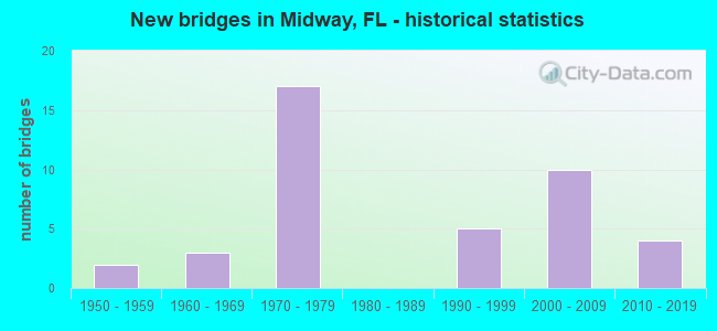
- New bridges - historical statistics
- 21950-1959
- 31960-1969
- 171970-1979
- 51990-1999
- 102000-2009
- 42010-2019


- Bridge Condition - Deck
- 19.4%Good
- 74.2%Satisfactory
- 6.5%Fair

- Bridge Condition - Superstructure
- 3.2%Very good
- 51.6%Good
- 22.6%Satisfactory
- 12.9%Fair
- 9.7%Poor

- Bridge Condition - Substructure
- 12.9%Very good
- 48.4%Good
- 25.8%Satisfactory
- 6.5%Fair
- 6.5%Poor

- Bridge Condition - Channel
- 12.1%Excellent
- 33.3%Very good
- 21.2%Good
- 24.2%Satisfactory
- 6.1%Fair
- 3.0%Poor

- Bridge Condition - Culverts
- 33.3%Good
- 66.7%Satisfactory
Find on map >> Show street view
Structure Number: 500045, Location: 6.5 Mi South of US90/SR10 (Lat: 30.512372, Lng: -84.523653), Route carried "on" structure: County highway 268, Year Built: 1959, Status: Posted for load, Structure Length: 15.24m (50.00ft), Average Daily Traffic: 4,500 (year 2020), Truck Traffic: 5%, Average Future Daily Traffic: 4,950 (year 2040), Design Load: H 15, Features Intersected: Little River
Minimum Vertical Clearance: 30+ m (98+ ft), Kilometerpoint: 10.390, Lanes on structure: 2, Owner: County Highway Agency, Approaching Roadway Width: 6.6m (21.7ft), Material/Design: Concrete, Design/Construction: Slab, Number Of Spans In Main Unit: 25, Length of Maximum Span: 6.1m (20.0ft), Curb-To-Curb Width: 7.3m (24.0ft), Out-to-Out Width: 7.8m (25.6ft)
Condition: Deck: Satisfactory, Superstructure: Satisfactory, Substructure: Poor, Channel: Poor, Operating Rating: 22.3 metric tons, Method Used To Determine Operating Rating: Load and Resistance Factor (LRFR), Inventory Rating: 17.2 metric tons, Method Used To Determine Inventory Rating: Load and Resistance Factor (LRFR), Structural Evaluation: Meets minimum limits, Deck Geometry: High priority of replacement, Waterway Adequacy: Better than present minimum criteria, Approach Roadway Alignment: Equal to present desirable criteria, Bridge Posting: Required (Relationship of Operating Rating to Maximum Legal Load: 20.0 - 29.9% below), Designated Inspection Frequency: Every 24 months, Underwater Inspection Frequency: Every 6 months, Other Special Inspection Frequency: Every 6 months, Inspection Date: December 2020, Underwater Inspection Date: December 2021, Other Special Inspection Date: December 2021, Deck Structure Type: Concrete Cast-file-Place, Wearing Surface/Protective System: Wearing Surface: Bituminous
Find on map >> Show street view
Structure Number: 500046, Location: 3.5 Mi South of US90/SR10 (Lat: 30.509139, Lng: -84.498119), Route carried "on" structure: County highway 268, Year Built: 1961, Status: Open, Structure Length: 0.75m (2.46ft), Average Daily Traffic: 5,600 (year 2019), Truck Traffic: 6%, Average Future Daily Traffic: 6,160 (year 2039), Features Intersected: Monroe Creek
Minimum Vertical Clearance: 30+ m (98+ ft), Kilometerpoint: 2.565, Lanes on structure: 2, Owner: County Highway Agency, Approaching Roadway Width: 6.6m (21.7ft), Material/Design: Concrete, Design/Construction: Culvert, Number Of Spans In Main Unit: 2, Length of Maximum Span: 3.7m (12.1ft)
Condition: Channel: Satisfactory, Culverts: Satisfactory, Operating Rating: 61.7 metric tons, Method Used To Determine Operating Rating: Allowable Stress (AS), Inventory Rating: 38.0 metric tons, Method Used To Determine Inventory Rating: Allowable Stress (AS), Structural Evaluation: Equal to present minimum criteria, Waterway Adequacy: Equal to present minimum criteria, Approach Roadway Alignment: Equal to present desirable criteria, Designated Inspection Frequency: Every 24 months, Inspection Date: December 2020
Find on map >> Show street view
Structure Number: 500052, Location: 11 Miles East of Quincy (Lat: 30.489986, Lng: -84.425725), Route carried "on" structure: Interstate 10, Year Built: 1971, Status: Open, Structure Length: 9.58m (31.43ft), Average Daily Traffic: 18,750 (year 2020), Truck Traffic: 24%, Average Future Daily Traffic: 32,531 (year 2042), Design Load: HS 20, Features Intersected: US90 SR10
Minimum Vertical Clearance: 30+ m (98+ ft), Kilometerpoint: 51.233, Lanes on structure: 3, Lanes under structure: 6, Base Highway Network: Yes, Owner: State Highway Agency, Approaching Roadway Width: 11.6m (38.1ft), Skew: 4 degrees, Material/Design: Prestressed concrete, Design/Construction: Stringer/Multi-beam, Number Of Spans In Main Unit: 4, Length of Maximum Span: 31.2m (102.4ft), Curb-To-Curb Width: 14.6m (47.9ft), Out-to-Out Width: 15.3m (50.2ft)
Condition: Deck: Satisfactory, Superstructure: Satisfactory, Substructure: Good, Operating Rating: 64.1 metric tons, Method Used To Determine Operating Rating: Load Factor (LF), Inventory Rating: 38.5 metric tons, Method Used To Determine Inventory Rating: Load Factor (LF), Structural Evaluation: Equal to present minimum criteria, Deck Geometry: Meets minimum limits, Underclear: Equal to present minimum criteria, Approach Roadway Alignment: Equal to present desirable criteria, Designated Inspection Frequency: Every 24 months, Inspection Date: January 2022, Deck Structure Type: Concrete Cast-file-Place
Find on map >> Show street view
Structure Number: 500054, Location: 11 Miles East of Quincy (Lat: 30.489650, Lng: -84.425533), Route carried "on" structure: Interstate 10, Year Built: 1971, Status: Open, Structure Length: 9.58m (31.43ft), Average Daily Traffic: 18,750 (year 2020), Truck Traffic: 24%, Average Future Daily Traffic: 32,531 (year 2042), Design Load: HS 20, Features Intersected: US90 SR10
Minimum Vertical Clearance: 30+ m (98+ ft), Kilometerpoint: 51.233, Lanes on structure: 3, Lanes under structure: 6, Base Highway Network: Yes, Owner: State Highway Agency, Approaching Roadway Width: 11.6m (38.1ft), Skew: 4 degrees, Material/Design: Prestressed concrete, Design/Construction: Stringer/Multi-beam, Number Of Spans In Main Unit: 4, Length of Maximum Span: 31.2m (102.4ft), Curb-To-Curb Width: 14.6m (47.9ft), Out-to-Out Width: 15.3m (50.2ft)
Condition: Deck: Satisfactory, Superstructure: Good, Substructure: Good, Operating Rating: 64.1 metric tons, Method Used To Determine Operating Rating: Load Factor (LF), Inventory Rating: 38.5 metric tons, Method Used To Determine Inventory Rating: Load Factor (LF), Structural Evaluation: Better than present minimum criteria, Deck Geometry: Meets minimum limits, Underclear: Superior to present desirable criteria, Approach Roadway Alignment: Equal to present desirable criteria, Designated Inspection Frequency: Every 24 months, Inspection Date: January 2022, Deck Structure Type: Concrete Cast-file-Place
Find on map >> Show street view
Structure Number: 500055, Location: 1.0 Mi West of Leon Cty. (Lat: 30.485917, Lng: -84.409739), Route carried "on" structure: Interstate 10, Year Built: 1972, Status: Open, Structure Length: 19.81m (64.99ft), Average Daily Traffic: 18,750 (year 2020), Truck Traffic: 24%, Average Future Daily Traffic: 32,531 (year 2042), Design Load: HL 93, Features Intersected: Ochlockonee Relief
Minimum Vertical Clearance: 30+ m (98+ ft), Kilometerpoint: 52.770, Lanes on structure: 2, Base Highway Network: Yes, Owner: State Highway Agency, Approaching Roadway Width: 11.6m (38.1ft), Material/Design: Prestressed concrete, Design/Construction: Stringer/Multi-beam, Number Of Spans In Main Unit: 13, Length of Maximum Span: 15.2m (49.9ft), Curb-To-Curb Width: 12.2m (40.0ft), Out-to-Out Width: 13.2m (43.3ft)
Condition: Deck: Satisfactory, Superstructure: Satisfactory, Substructure: Satisfactory, Channel: Very good, Operating Rating: 41.5 metric tons, Method Used To Determine Operating Rating: Load and Resistance Factor (LRFR), Inventory Rating: 32.0 metric tons, Method Used To Determine Inventory Rating: Load and Resistance Factor (LRFR), Structural Evaluation: Equal to present minimum criteria, Deck Geometry: Better than present minimum criteria, Waterway Adequacy: Equal to present desirable criteria, Approach Roadway Alignment: Equal to present desirable criteria, Designated Inspection Frequency: Every 24 months, Inspection Date: August 2020, Deck Structure Type: Concrete Cast-file-Place
Find on map >> Show street view
Structure Number: 500056, Location: 1.0 MI West of Leon Cnty (Lat: 30.485664, Lng: -84.409739), Route carried "on" structure: Interstate 10, Year Built: 1972, Status: Open, Structure Length: 19.81m (64.99ft), Average Daily Traffic: 18,750 (year 2020), Truck Traffic: 24%, Average Future Daily Traffic: 32,531 (year 2042), Design Load: HL 93, Features Intersected: Ochlockonee Relief
Minimum Vertical Clearance: 30+ m (98+ ft), Kilometerpoint: 52.770, Lanes on structure: 2, Base Highway Network: Yes, Owner: State Highway Agency, Approaching Roadway Width: 11.6m (38.1ft), Material/Design: Prestressed concrete, Design/Construction: Stringer/Multi-beam, Number Of Spans In Main Unit: 13, Length of Maximum Span: 15.2m (49.9ft), Curb-To-Curb Width: 12.2m (40.0ft), Out-to-Out Width: 13.2m (43.3ft)
Condition: Deck: Satisfactory, Superstructure: Satisfactory, Substructure: Satisfactory, Channel: Very good, Operating Rating: 41.5 metric tons, Method Used To Determine Operating Rating: Load and Resistance Factor (LRFR), Inventory Rating: 32.0 metric tons, Method Used To Determine Inventory Rating: Load and Resistance Factor (LRFR), Structural Evaluation: Equal to present minimum criteria, Deck Geometry: Better than present minimum criteria, Waterway Adequacy: Equal to present desirable criteria, Approach Roadway Alignment: Equal to present desirable criteria, Designated Inspection Frequency: Every 24 months, Inspection Date: August 2020, Deck Structure Type: Concrete Cast-file-Place
Find on map >> Show street view
Structure Number: 500097, Location: 4.7Miles East of SR267 (Lat: 30.529089, Lng: -84.517917), Route carried "on" structure: Interstate 10, Year Built: 1975, Year Reconstructed: 1993, Status: Open, Structure Length: 32.61m (106.99ft), Average Daily Traffic: 14,613 (year 2020), Truck Traffic: 24%, Average Future Daily Traffic: 25,354 (year 2042), Design Load: HS 20, Features Intersected: FG&A RR and Little River
Minimum Vertical Clearance: 30+ m (98+ ft), Kilometerpoint: 41.069, Lanes on structure: 2, Base Highway Network: Yes, Owner: State Highway Agency, Approaching Roadway Width: 11.6m (38.1ft), Skew: 3 degrees, Material/Design: Prestressed concrete, Design/Construction: Stringer/Multi-beam, Number Of Spans In Main Unit: 16, Length of Maximum Span: 21.3m (69.9ft), Curb-To-Curb Width: 12.2m (40.0ft), Out-to-Out Width: 13.1m (43.0ft)
Condition: Deck: Satisfactory, Superstructure: Good, Substructure: Satisfactory, Channel: Good, Operating Rating: 60.8 metric tons, Method Used To Determine Operating Rating: Load Factor (LF), Inventory Rating: 36.3 metric tons, Method Used To Determine Inventory Rating: Load Factor (LF), Structural Evaluation: Equal to present minimum criteria, Deck Geometry: Better than present minimum criteria, Underclear: Superior to present desirable criteria, Waterway Adequacy: Better than present minimum criteria, Approach Roadway Alignment: Equal to present desirable criteria, Designated Inspection Frequency: Every 24 months, Critical Feature Inspection Frequency: Every 24 months, Underwater Inspection Frequency: Every 24 months, Inspection Date: March 2020, Critical Feature Inspection Date: March 2020, Underwater Inspection Date: March 2020, Deck Structure Type: Concrete Cast-file-Place
Find on map >> Show street view
Structure Number: 500098, Location: 4.7 miles East of SR267 (Lat: 30.528842, Lng: -84.517889), Route carried "on" structure: Interstate 10, Year Built: 1975, Year Reconstructed: 1993, Status: Open, Structure Length: 31.42m (103.08ft), Average Daily Traffic: 14,613 (year 2020), Truck Traffic: 24%, Average Future Daily Traffic: 25,354 (year 2042), Design Load: HS 20, Features Intersected: FG&A RR and Little River
Minimum Vertical Clearance: 30+ m (98+ ft), Kilometerpoint: 41.069, Lanes on structure: 2, Base Highway Network: Yes, Owner: State Highway Agency, Approaching Roadway Width: 11.6m (38.1ft), Skew: 3 degrees, Material/Design: Prestressed concrete, Design/Construction: Stringer/Multi-beam, Number Of Spans In Main Unit: 15, Length of Maximum Span: 21.3m (69.9ft), Curb-To-Curb Width: 12.2m (40.0ft), Out-to-Out Width: 13.1m (43.0ft)
Condition: Deck: Satisfactory, Superstructure: Good, Substructure: Satisfactory, Channel: Good, Operating Rating: 67.1 metric tons, Method Used To Determine Operating Rating: Load Factor (LF), Inventory Rating: 39.9 metric tons, Method Used To Determine Inventory Rating: Load Factor (LF), Structural Evaluation: Equal to present minimum criteria, Deck Geometry: Better than present minimum criteria, Underclear: Superior to present desirable criteria, Waterway Adequacy: Better than present minimum criteria, Approach Roadway Alignment: Equal to present desirable criteria, Designated Inspection Frequency: Every 24 months, Critical Feature Inspection Frequency: Every 24 months, Underwater Inspection Frequency: Every 24 months, Inspection Date: March 2020, Critical Feature Inspection Date: March 2020, Underwater Inspection Date: March 2020, Deck Structure Type: Concrete Cast-file-Place
Find on map >> Show street view
Structure Number: 500102, Location: 2.0MI West of US90 SR10 (Lat: 30.501881, Lng: -84.455953), Route carried "on" structure: County highway 159, Year Built: 1971, Status: Open, Structure Length: 7.38m (24.21ft), Average Daily Traffic: 5,300 (year 2020), Truck Traffic: 7%, Average Future Daily Traffic: 9,196 (year 2042), Design Load: HL 93, Features Intersected: I10 SR8
Minimum Vertical Clearance: 30+ m (98+ ft), Kilometerpoint: 7.638, Lanes on structure: 2, Lanes under structure: 4, Owner: State Highway Agency, Approaching Roadway Width: 6.1m (20.0ft), Material/Design: Prestressed concrete, Design/Construction: Stringer/Multi-beam, Number Of Spans In Main Unit: 4, Length of Maximum Span: 27.1m (88.9ft), Curb-To-Curb Width: 9.8m (32.2ft), Out-to-Out Width: 10.4m (34.1ft)
Condition: Deck: Satisfactory, Superstructure: Good, Substructure: Good, Operating Rating: 30.7 metric tons, Method Used To Determine Operating Rating: Load and Resistance Factor (LRFR), Inventory Rating: 10.8 metric tons, Method Used To Determine Inventory Rating: Load and Resistance Factor (LRFR), Structural Evaluation: High priority of corrective action, Deck Geometry: Meets minimum limits, Underclear: Somewhat better than minimum adequacy, Approach Roadway Alignment: Equal to present desirable criteria, Designated Inspection Frequency: Every 24 months, Inspection Date: Febuary 2022, Deck Structure Type: Concrete Cast-file-Place
Find on map >> Show street view
Structure Number: 500103, Location: 4.0 mi. West of US90,SR10 (Lat: 30.517139, Lng: -84.483278), Route carried "on" structure: Interstate 10, Year Built: 1972, Status: Open, Structure Length: 0.87m (2.85ft), Average Daily Traffic: 14,613 (year 2020), Truck Traffic: 24%, Average Future Daily Traffic: 25,354 (year 2042), Design Load: HS 20, Features Intersected: Monroe Creek
Minimum Vertical Clearance: 30+ m (98+ ft), Kilometerpoint: 44.854, Lanes on structure: 2, Base Highway Network: Yes, Owner: State Highway Agency, Approaching Roadway Width: 11.6m (38.1ft), Material/Design: Concrete, Design/Construction: Culvert, Number Of Spans In Main Unit: 3, Length of Maximum Span: 2.7m (8.9ft)
Condition: Channel: Satisfactory, Culverts: Satisfactory, Structural Evaluation: Equal to present minimum criteria, Waterway Adequacy: Better than present minimum criteria, Approach Roadway Alignment: Equal to present desirable criteria, Designated Inspection Frequency: Every 24 months, Inspection Date: Febuary 2022
Find on map >> Show street view
Structure Number: 500104, Location: 4.0 mi. West of US90,SR10 (Lat: 30.518139, Lng: -84.482833), Route carried "on" structure: Interstate 10, Year Built: 1972, Status: Open, Structure Length: 0.87m (2.85ft), Average Daily Traffic: 14,613 (year 2020), Truck Traffic: 24%, Average Future Daily Traffic: 25,354 (year 2042), Design Load: HS 20, Features Intersected: Monroe Creek
Minimum Vertical Clearance: 30+ m (98+ ft), Kilometerpoint: 44.854, Lanes on structure: 2, Base Highway Network: Yes, Owner: State Highway Agency, Approaching Roadway Width: 11.6m (38.1ft), Material/Design: Concrete, Design/Construction: Culvert, Number Of Spans In Main Unit: 3, Length of Maximum Span: 2.7m (8.9ft)
Condition: Channel: Satisfactory, Culverts: Good, Structural Evaluation: Better than present minimum criteria, Waterway Adequacy: Better than present minimum criteria, Approach Roadway Alignment: Equal to present desirable criteria, Designated Inspection Frequency: Every 24 months, Inspection Date: Febuary 2022
Find on map >> Show street view
Structure Number: 500112, Location: 0.1mi. East of US90 (Lat: 30.488333, Lng: -84.420000), Route carried "on" structure: Interstate 10, Year Built: 1972, Status: Open, Structure Length: 0.98m (3.22ft), Average Daily Traffic: 37,500 (year 2020), Truck Traffic: 24%, Average Future Daily Traffic: 65,062 (year 2042), Design Load: HS 20, Features Intersected: Midway Branch
Minimum Vertical Clearance: 30+ m (98+ ft), Kilometerpoint: 51.855, Lanes on structure: 6, Base Highway Network: Yes, Owner: State Highway Agency, Approaching Roadway Width: 29.6m (97.1ft), Skew: 12 degrees, Material/Design: Concrete, Design/Construction: Culvert, Number Of Spans In Main Unit: 3, Length of Maximum Span: 2.7m (8.9ft)
Condition: Channel: Good, Culverts: Good, Operating Rating: 56.4 metric tons, Method Used To Determine Operating Rating: Load and Resistance Factor (LRFR), Inventory Rating: 36.3 metric tons, Method Used To Determine Inventory Rating: Load and Resistance Factor (LRFR), Structural Evaluation: Better than present minimum criteria, Waterway Adequacy: Better than present minimum criteria, Approach Roadway Alignment: Equal to present desirable criteria, Designated Inspection Frequency: Every 24 months, Inspection Date: January 2022
Find on map >> Show street view
Structure Number: 50012, Location: 0.06mi. South of I10 (Lat: 30.487306, Lng: -84.424972), Route carried "on" structure: Ramp US 90, Year Built: 1969, Status: Open, Structure Length: 1.48m (4.86ft), Average Daily Traffic: 18,100 (year 2020), Truck Traffic: 11%, Average Future Daily Traffic: 19,910 (year 2040), Design Load: HS 20+Mod, Features Intersected: Midway Branch
Minimum Vertical Clearance: 30+ m (98+ ft), Kilometerpoint: 19.690, Lanes on structure: 6, Base Highway Network: Yes, Owner: State Highway Agency, Approaching Roadway Width: 26.2m (86.0ft), Skew: 23 degrees, Material/Design: Concrete, Design/Construction: Culvert, Number Of Spans In Main Unit: 3, Length of Maximum Span: 4.4m (14.4ft)
Condition: Channel: Satisfactory, Culverts: Satisfactory, Operating Rating: 83.0 metric tons, Method Used To Determine Operating Rating: Load Factor (LF), Inventory Rating: 49.8 metric tons, Method Used To Determine Inventory Rating: Load Factor (LF), Structural Evaluation: Equal to present minimum criteria, Waterway Adequacy: Better than present minimum criteria, Approach Roadway Alignment: Equal to present desirable criteria, Designated Inspection Frequency: Every 24 months, Inspection Date: January 2022
Find on map >> Show street view
Structure Number: 500123, Location: 0.3Mi. West of Leon Co. (Lat: 30.478283, Lng: -84.413694), Route carried "on" structure: US 90, Year Built: 1995, Status: Open, Structure Length: 15.36m (50.39ft), Average Daily Traffic: 10,250 (year 2020), Truck Traffic: 10%, Average Future Daily Traffic: 17,784 (year 2042), Design Load: HS 20, Features Intersected: Ochlockonee Relief
Minimum Vertical Clearance: 30+ m (98+ ft), Kilometerpoint: 20.936, Lanes on structure: 2, Base Highway Network: Yes, Owner: State Highway Agency, Approaching Roadway Width: 8.5m (27.9ft), Material/Design: Prestressed concrete, Design/Construction: Stringer/Multi-beam, Number Of Spans In Main Unit: 7, Length of Maximum Span: 21.9m (71.9ft), Curb-To-Curb Width: 12.2m (40.0ft), Out-to-Out Width: 13.1m (43.0ft)
Condition: Deck: Satisfactory, Superstructure: Good, Substructure: Good, Channel: Excellent, Structural Evaluation: Better than present minimum criteria, Deck Geometry: Better than present minimum criteria, Waterway Adequacy: Superior to present desirable criteria, Approach Roadway Alignment: Equal to present desirable criteria, Designated Inspection Frequency: Every 24 months, Underwater Inspection Frequency: Every 24 months, Inspection Date: January 2022, Underwater Inspection Date: January 2022, Deck Structure Type: Concrete Cast-file-Place
Find on map >> Show street view
Structure Number: 500124, Location: 0.5mi N of Leon County (Lat: 30.555119, Lng: -84.384864), Route carried "on" structure: US 27, Year Built: 2000, Status: Open, Structure Length: 41.59m (136.45ft), Average Daily Traffic: 8,750 (year 2020), Truck Traffic: 11%, Average Future Daily Traffic: 15,181 (year 2042), Design Load: HS 20, Features Intersected: Ochlockonee River
Minimum Vertical Clearance: 30+ m (98+ ft), Kilometerpoint: 25.243, Lanes on structure: 2, Base Highway Network: Yes, Owner: State Highway Agency, Approaching Roadway Width: 8.5m (27.9ft), Material/Design: Prestressed concrete continuous, Design/Construction: Stringer/Multi-beam, Number Of Spans In Main Unit: 21, Length of Maximum Span: 28.0m (91.9ft), Curb-To-Curb Width: 12.2m (40.0ft), Out-to-Out Width: 12.9m (42.3ft)
Condition: Deck: Satisfactory, Superstructure: Good, Substructure: Good, Channel: Very good, Operating Rating: 58.6 metric tons, Method Used To Determine Operating Rating: Load Factor (LF), Inventory Rating: 35.1 metric tons, Method Used To Determine Inventory Rating: Load Factor (LF), Structural Evaluation: Better than present minimum criteria, Deck Geometry: Better than present minimum criteria, Waterway Adequacy: Equal to present desirable criteria, Approach Roadway Alignment: Equal to present desirable criteria, Designated Inspection Frequency: Every 24 months, Underwater Inspection Frequency: Every 24 months, Inspection Date: January 2022, Underwater Inspection Date: January 2022, Deck Structure Type: Concrete Cast-file-Place
Find on map >> Show street view
Structure Number: 500125, Location: 0.5mi N of Leon County (Lat: 30.559728, Lng: -84.387897), Route carried "on" structure: US 27, Year Built: 2000, Status: Open, Structure Length: 21.18m (69.49ft), Average Daily Traffic: 8,750 (year 2020), Truck Traffic: 11%, Average Future Daily Traffic: 15,181 (year 2042), Design Load: HS 20, Features Intersected: Ochlockonee Relief
Minimum Vertical Clearance: 30+ m (98+ ft), Kilometerpoint: 24.760, Lanes on structure: 2, Base Highway Network: Yes, Owner: State Highway Agency, Approaching Roadway Width: 9.8m (32.2ft), Material/Design: Prestressed concrete continuous, Design/Construction: Stringer/Multi-beam, Number Of Spans In Main Unit: 11, Length of Maximum Span: 19.3m (63.3ft), Curb-To-Curb Width: 12.2m (40.0ft), Out-to-Out Width: 12.9m (42.3ft)
Condition: Deck: Satisfactory, Superstructure: Good, Substructure: Good, Channel: Very good, Operating Rating: 58.2 metric tons, Method Used To Determine Operating Rating: Load Factor (LF), Inventory Rating: 34.9 metric tons, Method Used To Determine Inventory Rating: Load Factor (LF), Structural Evaluation: Better than present minimum criteria, Deck Geometry: Better than present minimum criteria, Waterway Adequacy: Equal to present desirable criteria, Approach Roadway Alignment: Equal to present desirable criteria, Designated Inspection Frequency: Every 24 months, Underwater Inspection Frequency: Every 24 months, Inspection Date: January 2022, Underwater Inspection Date: January 2022, Deck Structure Type: Concrete Cast-file-Place
Find on map >> Show street view
Structure Number: 500126, Location: 0.5mi N of Leon County (Lat: 30.559656, Lng: -84.388036), Route carried "on" structure: US 27, Year Built: 2001, Status: Open, Structure Length: 21.19m (69.52ft), Average Daily Traffic: 8,750 (year 2020), Truck Traffic: 11%, Average Future Daily Traffic: 15,181 (year 2042), Design Load: HS 20, Features Intersected: Ochlockonee Relief
Minimum Vertical Clearance: 30+ m (98+ ft), Kilometerpoint: 24.760, Lanes on structure: 2, Base Highway Network: Yes, Owner: State Highway Agency, Approaching Roadway Width: 9.8m (32.2ft), Material/Design: Prestressed concrete continuous, Design/Construction: Stringer/Multi-beam, Number Of Spans In Main Unit: 11, Length of Maximum Span: 19.3m (63.3ft), Curb-To-Curb Width: 12.2m (40.0ft), Out-to-Out Width: 13.0m (42.7ft)
Condition: Deck: Satisfactory, Superstructure: Good, Substructure: Good, Channel: Very good, Operating Rating: 58.2 metric tons, Method Used To Determine Operating Rating: Load Factor (LF), Inventory Rating: 34.9 metric tons, Method Used To Determine Inventory Rating: Load Factor (LF), Structural Evaluation: Better than present minimum criteria, Deck Geometry: Better than present minimum criteria, Waterway Adequacy: Equal to present desirable criteria, Approach Roadway Alignment: Equal to present desirable criteria, Designated Inspection Frequency: Every 24 months, Underwater Inspection Frequency: Every 24 months, Inspection Date: January 2022, Underwater Inspection Date: January 2022, Deck Structure Type: Concrete Cast-file-Place
Find on map >> Show street view
Structure Number: 500127, Location: 0.2mi N of Leon County (Lat: 30.555039, Lng: -84.385000), Route carried "on" structure: US 27, Year Built: 2001, Status: Open, Structure Length: 41.59m (136.45ft), Average Daily Traffic: 8,750 (year 2020), Truck Traffic: 11%, Average Future Daily Traffic: 15,181 (year 2042), Design Load: HS 20, Features Intersected: Ochlockonee River
Minimum Vertical Clearance: 30+ m (98+ ft), Kilometerpoint: 25.243, Lanes on structure: 2, Base Highway Network: Yes, Owner: State Highway Agency, Approaching Roadway Width: 8.5m (27.9ft), Material/Design: Prestressed concrete continuous, Design/Construction: Stringer/Multi-beam, Number Of Spans In Main Unit: 21, Length of Maximum Span: 28.0m (91.9ft), Curb-To-Curb Width: 12.2m (40.0ft), Out-to-Out Width: 13.0m (42.7ft)
Condition: Deck: Satisfactory, Superstructure: Good, Substructure: Good, Channel: Excellent, Operating Rating: 58.6 metric tons, Method Used To Determine Operating Rating: Load Factor (LF), Inventory Rating: 35.1 metric tons, Method Used To Determine Inventory Rating: Load Factor (LF), Structural Evaluation: Better than present minimum criteria, Deck Geometry: Better than present minimum criteria, Waterway Adequacy: Equal to present desirable criteria, Approach Roadway Alignment: Equal to present desirable criteria, Designated Inspection Frequency: Every 24 months, Underwater Inspection Frequency: Every 24 months, Inspection Date: January 2022, Underwater Inspection Date: January 2022, Deck Structure Type: Concrete Cast-file-Place
Find on map >> Show street view
Structure Number: 500151, Location: 4.5 Miles E. of SR12 (Lat: 30.553758, Lng: -84.514325), Route carried "on" structure: US 90, Year Built: 2015, Status: Open, Structure Length: 13.30m (43.64ft), Average Daily Traffic: 7,050 (year 2020), Truck Traffic: 7%, Average Future Daily Traffic: 12,232 (year 2042), Design Load: HL 93, Features Intersected: Little River
Minimum Vertical Clearance: 30+ m (98+ ft), Kilometerpoint: 7.265, Lanes on structure: 2, Base Highway Network: Yes, Owner: State Highway Agency, Approaching Roadway Width: 10.4m (34.1ft), Material/Design: Prestressed concrete, Design/Construction: Stringer/Multi-beam, Number Of Spans In Main Unit: 4, Length of Maximum Span: 33.6m (110.2ft), Curb-To-Curb Width: 12.2m (40.0ft), Out-to-Out Width: 13.1m (43.0ft)
Condition: Deck: Good, Superstructure: Good, Substructure: Very good, Channel: Good, Operating Rating: 34.7 metric tons, Method Used To Determine Operating Rating: Load and Resistance Factor (LRFR), Inventory Rating: 32.7 metric tons, Method Used To Determine Inventory Rating: Load and Resistance Factor (LRFR), Structural Evaluation: Better than present minimum criteria, Deck Geometry: Better than present minimum criteria, Waterway Adequacy: Equal to present desirable criteria, Approach Roadway Alignment: Equal to present desirable criteria, Designated Inspection Frequency: Every 24 months, Inspection Date: Febuary 2022, Deck Structure Type: Concrete Precast Panels
Find on map >> Show street view
Structure Number: 500152, Location: 4.5 Miles E. of SR12 (Lat: 30.553533, Lng: -84.514222), Route carried "on" structure: US 90, Year Built: 2015, Status: Open, Structure Length: 13.30m (43.64ft), Average Daily Traffic: 7,050 (year 2020), Truck Traffic: 7%, Average Future Daily Traffic: 12,232 (year 2042), Design Load: HL 93, Features Intersected: Little River
Minimum Vertical Clearance: 30+ m (98+ ft), Kilometerpoint: 7.265, Lanes on structure: 2, Owner: State Highway Agency, Approaching Roadway Width: 13.1m (43.0ft), Material/Design: Prestressed concrete, Design/Construction: Stringer/Multi-beam, Number Of Spans In Main Unit: 4, Length of Maximum Span: 33.6m (110.2ft), Curb-To-Curb Width: 12.2m (40.0ft), Out-to-Out Width: 13.1m (43.0ft)
Condition: Deck: Good, Superstructure: Good, Substructure: Very good, Channel: Very good, Operating Rating: 38.6 metric tons, Method Used To Determine Operating Rating: Load and Resistance Factor (LRFR), Inventory Rating: 34.9 metric tons, Method Used To Determine Inventory Rating: Load and Resistance Factor (LRFR), Structural Evaluation: Better than present minimum criteria, Deck Geometry: Better than present minimum criteria, Waterway Adequacy: Equal to present desirable criteria, Approach Roadway Alignment: Equal to present desirable criteria, Designated Inspection Frequency: Every 24 months, Inspection Date: Febuary 2022, Deck Structure Type: Concrete Precast Panels
Find on map >> Show street view
Structure Number: 500153, Location: 0.1 Mi E. of Little River (Lat: 30.553472, Lng: -84.510639), Route carried "on" structure: US 90, Year Built: 2015, Status: Open, Structure Length: 3.36m (11.02ft), Average Daily Traffic: 7,050 (year 2020), Truck Traffic: 7%, Average Future Daily Traffic: 12,232 (year 2042), Design Load: HL 93, Features Intersected: Hurricane Creek
Minimum Vertical Clearance: 30+ m (98+ ft), Kilometerpoint: 7.681, Lanes on structure: 2, Base Highway Network: Yes, Owner: State Highway Agency, Approaching Roadway Width: 10.4m (34.1ft), Material/Design: Prestressed concrete, Design/Construction: Stringer/Multi-beam, Number Of Spans In Main Unit: 1, Length of Maximum Span: 33.6m (110.2ft), Curb-To-Curb Width: 12.2m (40.0ft), Out-to-Out Width: 13.1m (43.0ft)
Condition: Deck: Good, Superstructure: Very good, Substructure: Very good, Channel: Very good, Operating Rating: 36.6 metric tons, Method Used To Determine Operating Rating: Load and Resistance Factor (LRFR), Inventory Rating: 33.0 metric tons, Method Used To Determine Inventory Rating: Load and Resistance Factor (LRFR), Structural Evaluation: Equal to present desirable criteria, Deck Geometry: Better than present minimum criteria, Waterway Adequacy: Equal to present desirable criteria, Approach Roadway Alignment: Equal to present desirable criteria, Designated Inspection Frequency: Every 24 months, Inspection Date: Febuary 2022, Deck Structure Type: Concrete Precast Panels
Find on map >> Show street view
Structure Number: 500154, Location: 4.6 miles east of SR12 (Lat: 30.553236, Lng: -84.510436), Route carried "on" structure: US 90, Year Built: 2015, Status: Open, Structure Length: 3.36m (11.02ft), Average Daily Traffic: 7,050 (year 2020), Truck Traffic: 7%, Average Future Daily Traffic: 12,232 (year 2042), Design Load: HL 93, Features Intersected: Hurricane Creek
Minimum Vertical Clearance: 30+ m (98+ ft), Kilometerpoint: 7.681, Lanes on structure: 2, Base Highway Network: Yes, Owner: State Highway Agency, Approaching Roadway Width: 10.4m (34.1ft), Material/Design: Prestressed concrete, Design/Construction: Stringer/Multi-beam, Number Of Spans In Main Unit: 1, Length of Maximum Span: 33.6m (110.2ft), Curb-To-Curb Width: 12.2m (40.0ft), Out-to-Out Width: 12.2m (40.0ft)
Condition: Deck: Good, Superstructure: Good, Substructure: Good, Channel: Very good, Operating Rating: 39.6 metric tons, Method Used To Determine Operating Rating: Load and Resistance Factor (LRFR), Inventory Rating: 35.9 metric tons, Method Used To Determine Inventory Rating: Load and Resistance Factor (LRFR), Structural Evaluation: Better than present minimum criteria, Deck Geometry: Better than present minimum criteria, Waterway Adequacy: Equal to present desirable criteria, Approach Roadway Alignment: Equal to present desirable criteria, Designated Inspection Frequency: Every 24 months, Inspection Date: Febuary 2022, Deck Structure Type: Concrete Precast Panels
Find on map >> Show street view
Structure Number: 500803, Location: 0.73 Mi E of Central Road (Lat: 30.469556, Lng: -84.463139), Route carried "on" structure: State lands road , Year Built: 2003, Status: Open, Structure Length: 1.22m (4.00ft), Average Daily Traffic: 25 (year 2019), Average Future Daily Traffic: 43 (year 2039), Design Load: H 20, Features Intersected: Hunter Creek, Facility Carried by Structure: New Bridge Road
Minimum Vertical Clearance: 30+ m (98+ ft), Kilometerpoint: 1.176, Lanes on structure: 1, Owner: State Park, Forest, or Reservation Agency, Approaching Roadway Width: 3.0m (9.8ft), Material/Design: Steel continuous, Design/Construction: Truss - Thru, Number Of Spans In Main Unit: 2, Length of Maximum Span: 6.1m (20.0ft), Curb or Sidewalk Widths: Left: 0.2m (0.7ft), Right: 0.2m (0.7ft), Curb-To-Curb Width: 3.4m (11.2ft), Out-to-Out Width: 3.4m (11.2ft)
Condition: Deck: Satisfactory, Superstructure: Poor, Substructure: Good, Channel: Good, Operating Rating: 33.6 metric tons, Method Used To Determine Operating Rating: Load Testing, Inventory Rating: 32.7 metric tons, Method Used To Determine Inventory Rating: Load Testing, Structural Evaluation: Meets minimum limits, Deck Geometry: High priority of corrective action, Waterway Adequacy: Meets minimum limits, Approach Roadway Alignment: Equal to present desirable criteria, Designated Inspection Frequency: Every 24 months, Critical Feature Inspection Frequency: Every 12 months, Other Special Inspection Frequency: Every 12 months, Inspection Date: August 2021, Critical Feature Inspection Date: August 2021, Other Special Inspection Date: August 2021, Deck Structure Type: Open Grating
Find on map >> Show street view
Structure Number: 500804, Location: 0.94 Mi E Cattle Gap Road (Lat: 30.462778, Lng: -84.521944), Route carried "on" structure: State lands road , Year Built: 2003, Status: Open, Structure Length: 1.22m (4.00ft), Average Daily Traffic: 25 (year 2018), Average Future Daily Traffic: 43 (year 2038), Design Load: H 20, Features Intersected: Mule Creek, Facility Carried by Structure: Deer Pen Road
Minimum Vertical Clearance: 30+ m (98+ ft), Kilometerpoint: 1.511, Lanes on structure: 1, Owner: State Park, Forest, or Reservation Agency, Approaching Roadway Width: 3.0m (9.8ft), Material/Design: Steel continuous, Design/Construction: Truss - Thru, Number Of Spans In Main Unit: 2, Length of Maximum Span: 6.1m (20.0ft), Curb or Sidewalk Widths: Left: 0.2m (0.7ft), Right: 0.2m (0.7ft), Curb-To-Curb Width: 3.4m (11.2ft), Out-to-Out Width: 3.4m (11.2ft)
Condition: Deck: Satisfactory, Superstructure: Fair, Substructure: Good, Channel: Good, Operating Rating: 33.6 metric tons, Method Used To Determine Operating Rating: Load Testing, Inventory Rating: 32.7 metric tons, Method Used To Determine Inventory Rating: Load Testing, Structural Evaluation: Somewhat better than minimum adequacy, Deck Geometry: High priority of corrective action, Waterway Adequacy: Meets minimum limits, Approach Roadway Alignment: Equal to present desirable criteria, Designated Inspection Frequency: Every 24 months, Critical Feature Inspection Frequency: Every 24 months, Inspection Date: August 2021, Critical Feature Inspection Date: August 2021, Deck Structure Type: Open Grating
Find on map >> Show street view
Structure Number: 500805, Location: 2.4 Mi S CR268 (Lat: 30.470167, Lng: -84.439444), Route carried "on" structure: State lands road , Year Built: 2009, Status: Posted for load, Structure Length: 0.91m (2.99ft), Average Daily Traffic: 25 (year 2020), Truck Traffic: 5%, Average Future Daily Traffic: 43 (year 2040), Features Intersected: Gully Branch, Facility Carried by Structure: New Bridge Road
Minimum Vertical Clearance: 30+ m (98+ ft), Kilometerpoint: 3.898, Lanes on structure: 1, Owner: State Park, Forest, or Reservation Agency, Approaching Roadway Width: 3.0m (9.8ft), Material/Design: Steel, Design/Construction: Truss - Thru, Number Of Spans In Main Unit: 1, Length of Maximum Span: 9.1m (29.9ft), Curb-To-Curb Width: 3.4m (11.2ft), Out-to-Out Width: 3.4m (11.2ft)
Condition: Deck: Satisfactory, Superstructure: Poor, Substructure: Good, Channel: Fair, Operating Rating: 16.7 metric tons, Method Used To Determine Operating Rating: Load Factor (LF), Inventory Rating: 9.8 metric tons, Method Used To Determine Inventory Rating: Load Factor (LF), Structural Evaluation: High priority of corrective action, Deck Geometry: High priority of corrective action, Approach Roadway Alignment: Equal to present desirable criteria, Bridge Posting: Required (Relationship of Operating Rating to Maximum Legal Load: 30.0 - 39.9% below), Designated Inspection Frequency: Every 24 months, Critical Feature Inspection Frequency: Every 12 months, Other Special Inspection Frequency: Every 12 months, Inspection Date: July 2021, Critical Feature Inspection Date: July 2021, Other Special Inspection Date: July 2021, Deck Structure Type: Open Grating
Find on map >> Show street view
Structure Number: 50092, Location: 0.3Mi. West of Leon Co. (Lat: 30.478392, Lng: -84.413578), Route carried "on" structure: US 90, Year Built: 1971, Status: Open, Structure Length: 15.36m (50.39ft), Average Daily Traffic: 10,250 (year 2020), Truck Traffic: 10%, Average Future Daily Traffic: 17,784 (year 2042), Design Load: HL 93, Features Intersected: Ochlockonee Relief
Minimum Vertical Clearance: 30+ m (98+ ft), Kilometerpoint: 20.936, Lanes on structure: 2, Base Highway Network: Yes, Owner: State Highway Agency, Approaching Roadway Width: 8.5m (27.9ft), Material/Design: Prestressed concrete, Design/Construction: Slab, Number Of Spans In Main Unit: 14, Length of Maximum Span: 11.0m (36.1ft), Curb-To-Curb Width: 11.8m (38.7ft), Out-to-Out Width: 12.9m (42.3ft)
Condition: Deck: Fair, Superstructure: Fair, Substructure: Satisfactory, Channel: Very good, Operating Rating: 47.7 metric tons, Method Used To Determine Operating Rating: Load and Resistance Factor (LRFR), Inventory Rating: 33.3 metric tons, Method Used To Determine Inventory Rating: Load and Resistance Factor (LRFR), Structural Evaluation: Somewhat better than minimum adequacy, Deck Geometry: Better than present minimum criteria, Waterway Adequacy: Equal to present desirable criteria, Approach Roadway Alignment: Equal to present desirable criteria, Designated Inspection Frequency: Every 24 months, Underwater Inspection Frequency: Every 24 months, Inspection Date: January 2022, Underwater Inspection Date: January 2022, Deck Structure Type: Concrete Precast Panels, Wearing Surface/Protective System: Wearing Surface: Bituminous
Find on map >> Show street view
Structure Number: 504051, Location: 2.0 Mi South of US10/SR8 (Lat: 30.512144, Lng: -84.521239), Route carried "on" structure: County highway 268, Year Built: 1959, Status: Posted for load-capacity, Structure Length: 0.61m (2.00ft), Average Daily Traffic: 5,600 (year 2020), Truck Traffic: 6%, Average Future Daily Traffic: 6,160 (year 2040), Features Intersected: Unnamed Sinkhole
Minimum Vertical Clearance: 30+ m (98+ ft), Kilometerpoint: 0.161, Lanes on structure: 2, Owner: County Highway Agency, Approaching Roadway Width: 6.7m (22.0ft), Material/Design: Steel, Design/Construction: Culvert, Number Of Spans In Main Unit: 1, Length of Maximum Span: 6.1m (20.0ft)
Condition: Channel: Satisfactory, Culverts: Satisfactory, Operating Rating: 70.8 metric tons, Method Used To Determine Operating Rating: Allowable Stress (AS), Inventory Rating: 51.7 metric tons, Method Used To Determine Inventory Rating: Allowable Stress (AS), Structural Evaluation: Equal to present minimum criteria, Waterway Adequacy: Better than present minimum criteria, Approach Roadway Alignment: Equal to present desirable criteria, Designated Inspection Frequency: Every 24 months, Underwater Inspection Frequency: Every 24 months, Inspection Date: May 2021, Underwater Inspection Date: May 2021
Find on map >> Show street view
Structure Number: 550016, Location: Gadsden-Leon Co. Line (Lat: 30.473950, Lng: -84.407861), Route carried "on" structure: US 90, Year Built: 1971, Status: Open, Structure Length: 23.61m (77.46ft), Average Daily Traffic: 10,250 (year 2020), Truck Traffic: 10%, Average Future Daily Traffic: 17,784 (year 2042), Design Load: HS 20, Features Intersected: Ochlockonee River
Minimum Vertical Clearance: 30+ m (98+ ft), Kilometerpoint: 0.000, Lanes on structure: 2, Base Highway Network: Yes, Owner: State Highway Agency, Approaching Roadway Width: 10.1m (33.1ft), Skew: 9 degrees, Material/Design: Steel continuous, Design/Construction: Stringer/Multi-beam, Number Of Spans In Main Unit: 3, Number Of Approach Spans: 16, Length of Maximum Span: 21.9m (71.9ft), Curb-To-Curb Width: 11.9m (39.0ft), Out-to-Out Width: 12.9m (42.3ft)
Condition: Deck: Satisfactory, Superstructure: Good, Substructure: Satisfactory, Channel: Very good, Operating Rating: 50.2 metric tons, Method Used To Determine Operating Rating: Load Factor (LF), Inventory Rating: 31.2 metric tons, Method Used To Determine Inventory Rating: Load Factor (LF), Structural Evaluation: Equal to present minimum criteria, Deck Geometry: Better than present minimum criteria, Waterway Adequacy: Equal to present desirable criteria, Approach Roadway Alignment: Equal to present desirable criteria, Designated Inspection Frequency: Every 24 months, Underwater Inspection Frequency: Every 24 months, Inspection Date: June 2020, Underwater Inspection Date: June 2020, Deck Structure Type: Concrete Cast-file-Place
Find on map >> Show street view
Structure Number: 55005, Location: Gadsden-Leon Co. Line (Lat: 30.485208, Lng: -84.396803), Route carried "on" structure: Interstate 10, Year Built: 1972, Status: Open, Structure Length: 36.88m (121.00ft), Average Daily Traffic: 18,750 (year 2020), Truck Traffic: 24%, Average Future Daily Traffic: 32,531 (year 2042), Design Load: HS 20, Features Intersected: Ochlockonee River
Minimum Vertical Clearance: 30+ m (98+ ft), Kilometerpoint: 0.000, Lanes on structure: 2, Base Highway Network: Yes, Owner: State Highway Agency, Approaching Roadway Width: 11.6m (38.1ft), Material/Design: Prestressed concrete, Design/Construction: Stringer/Multi-beam, Number Of Spans In Main Unit: 18, Length of Maximum Span: 32.0m (105.0ft), Curb-To-Curb Width: 12.2m (40.0ft), Out-to-Out Width: 12.9m (42.3ft)
Condition: Deck: Satisfactory, Superstructure: Good, Substructure: Fair, Channel: Satisfactory, Operating Rating: 80.7 metric tons, Method Used To Determine Operating Rating: Load Factor (LF), Inventory Rating: 48.4 metric tons, Method Used To Determine Inventory Rating: Load Factor (LF), Structural Evaluation: Somewhat better than minimum adequacy, Deck Geometry: Better than present minimum criteria, Waterway Adequacy: Better than present minimum criteria, Approach Roadway Alignment: Equal to present desirable criteria, Designated Inspection Frequency: Every 24 months, Critical Feature Inspection Frequency: Every 24 months, Underwater Inspection Frequency: Every 24 months, Inspection Date: January 2021, Critical Feature Inspection Date: January 2021, Underwater Inspection Date: January 2021, Deck Structure Type: Concrete Cast-file-Place
Find on map >> Show street view
Structure Number: 550089, Location: Gadsden-Leon Co Line (Lat: 30.484961, Lng: -84.396861), Route carried "on" structure: Interstate 10, Year Built: 1972, Status: Open, Structure Length: 36.88m (121.00ft), Average Daily Traffic: 18,750 (year 2020), Truck Traffic: 24%, Average Future Daily Traffic: 32,531 (year 2042), Design Load: HS 20, Features Intersected: Ochlockonee River
Minimum Vertical Clearance: 30+ m (98+ ft), Kilometerpoint: 0.000, Lanes on structure: 2, Base Highway Network: Yes, Owner: State Highway Agency, Approaching Roadway Width: 11.6m (38.1ft), Material/Design: Prestressed concrete, Design/Construction: Stringer/Multi-beam, Number Of Spans In Main Unit: 18, Length of Maximum Span: 32.0m (105.0ft), Curb-To-Curb Width: 12.2m (40.0ft), Out-to-Out Width: 12.9m (42.3ft)
Condition: Deck: Satisfactory, Superstructure: Satisfactory, Substructure: Fair, Channel: Fair, Operating Rating: 80.7 metric tons, Method Used To Determine Operating Rating: Load Factor (LF), Inventory Rating: 48.4 metric tons, Method Used To Determine Inventory Rating: Load Factor (LF), Structural Evaluation: Somewhat better than minimum adequacy, Deck Geometry: Better than present minimum criteria, Waterway Adequacy: Better than present minimum criteria, Approach Roadway Alignment: Equal to present desirable criteria, Designated Inspection Frequency: Every 24 months, Critical Feature Inspection Frequency: Every 24 months, Underwater Inspection Frequency: Every 24 months, Inspection Date: January 2021, Critical Feature Inspection Date: January 2021, Underwater Inspection Date: January 2021, Deck Structure Type: Concrete Cast-file-Place
Find on map >> Show street view
Structure Number: 550127, Location: Gadsden-Leon Co. Line (Lat: 30.473831, Lng: -84.407992), Route carried "on" structure: US 90, Year Built: 1995, Status: Open, Structure Length: 24.14m (79.20ft), Average Daily Traffic: 10,250 (year 2020), Truck Traffic: 10%, Average Future Daily Traffic: 17,784 (year 2042), Design Load: HS 20, Features Intersected: Ochlockonee River
Minimum Vertical Clearance: 30+ m (98+ ft), Kilometerpoint: 0.000, Lanes on structure: 2, Base Highway Network: Yes, Owner: State Highway Agency, Approaching Roadway Width: 10.1m (33.1ft), Skew: 9 degrees, Material/Design: Prestressed concrete, Design/Construction: Stringer/Multi-beam, Number Of Spans In Main Unit: 12, Length of Maximum Span: 21.9m (71.9ft), Curb-To-Curb Width: 12.2m (40.0ft), Out-to-Out Width: 13.1m (43.0ft)
Condition: Deck: Satisfactory, Superstructure: Good, Substructure: Good, Channel: Very good, Operating Rating: 73.5 metric tons, Method Used To Determine Operating Rating: Load Factor (LF), Inventory Rating: 43.5 metric tons, Method Used To Determine Inventory Rating: Load Factor (LF), Structural Evaluation: Better than present minimum criteria, Deck Geometry: Better than present minimum criteria, Waterway Adequacy: Equal to present desirable criteria, Approach Roadway Alignment: Equal to present desirable criteria, Designated Inspection Frequency: Every 24 months, Underwater Inspection Frequency: Every 24 months, Inspection Date: June 2020, Underwater Inspection Date: June 2020, Deck Structure Type: Concrete Cast-file-Place, Wearing Surface/Protective System: Wearing Surface: Monolithic Concrete
Find on map >> Show street view
Structure Number: 550801, Location: 1.5 Mi West of Geddie Rd (Lat: 30.453472, Lng: -84.422333), Route carried "on" structure: State lands road , Year Built: 2003, Status: Open, Structure Length: 0.91m (2.99ft), Average Daily Traffic: 25 (year 2019), Average Future Daily Traffic: 43 (year 2039), Design Load: H 20, Features Intersected: GW Creek, Facility Carried by Structure: Turkey Flat Road
Minimum Vertical Clearance: 30+ m (98+ ft), Kilometerpoint: 4.155, Lanes on structure: 1, Owner: State Park, Forest, or Reservation Agency, Approaching Roadway Width: 3.0m (9.8ft), Material/Design: Steel, Design/Construction: Truss - Thru, Number Of Spans In Main Unit: 1, Length of Maximum Span: 9.1m (29.9ft), Curb or Sidewalk Widths: Left: 0.2m (0.7ft), Right: 0.2m (0.7ft), Curb-To-Curb Width: 3.4m (11.2ft), Out-to-Out Width: 3.4m (11.2ft)
Condition: Deck: Satisfactory, Superstructure: Poor, Substructure: Good, Channel: Satisfactory, Operating Rating: 33.6 metric tons, Method Used To Determine Operating Rating: Load Testing, Inventory Rating: 32.7 metric tons, Method Used To Determine Inventory Rating: Load Testing, Structural Evaluation: Meets minimum limits, Deck Geometry: High priority of corrective action, Waterway Adequacy: Meets minimum limits, Approach Roadway Alignment: Equal to present desirable criteria, Designated Inspection Frequency: Every 24 months, Critical Feature Inspection Frequency: Every 12 months, Other Special Inspection Frequency: Every 12 months, Inspection Date: August 2021, Critical Feature Inspection Date: August 2021, Other Special Inspection Date: August 2021, Deck Structure Type: Open Grating
Find on map >> Show street view
Structure Number: 550802, Location: 0.17 Mi N of Stoneler Rd (Lat: 30.512194, Lng: -84.381528), Route carried "on" structure: State lands road , Year Built: 2003, Status: Open, Structure Length: 0.91m (2.99ft), Average Daily Traffic: 25 (year 2018), Average Future Daily Traffic: 43 (year 2038), Design Load: H 20, Features Intersected: Megan Creek, Facility Carried by Structure: Old Cemetery Road
Minimum Vertical Clearance: 30+ m (98+ ft), Kilometerpoint: 0.000, Lanes on structure: 1, Owner: State Park, Forest, or Reservation Agency, Approaching Roadway Width: 3.0m (9.8ft), Material/Design: Steel, Design/Construction: Truss - Thru, Number Of Spans In Main Unit: 1, Length of Maximum Span: 9.1m (29.9ft), Curb or Sidewalk Widths: Left: 0.2m (0.7ft), Right: 0.2m (0.7ft), Curb-To-Curb Width: 3.4m (11.2ft), Out-to-Out Width: 3.4m (11.2ft)
Condition: Deck: Satisfactory, Superstructure: Satisfactory, Substructure: Good, Channel: Good, Operating Rating: 33.6 metric tons, Method Used To Determine Operating Rating: Load Testing, Inventory Rating: 32.7 metric tons, Method Used To Determine Inventory Rating: Load Testing, Structural Evaluation: Equal to present minimum criteria, Deck Geometry: High priority of corrective action, Waterway Adequacy: Meets minimum limits, Approach Roadway Alignment: Equal to present desirable criteria, Designated Inspection Frequency: Every 24 months, Critical Feature Inspection Frequency: Every 24 months, Inspection Date: August 2021, Critical Feature Inspection Date: August 2021, Deck Structure Type: Open Grating
Find on map >> Show street view
Structure Number: 550803, Location: 0.9 Mi West of Geddie Rd (Lat: 30.454139, Lng: -84.411889), Route carried "on" structure: State lands road , Year Built: 2005, Status: Open, Structure Length: 1.22m (4.00ft), Average Daily Traffic: 25 (year 2017), Truck Traffic: 5%, Average Future Daily Traffic: 50 (year 2037), Design Load: HS 20, Features Intersected: Beaver Dam Creek, Facility Carried by Structure: Beaver Dam Road
Minimum Vertical Clearance: 30+ m (98+ ft), Kilometerpoint: 2.039, Lanes on structure: 1, Owner: State Park, Forest, or Reservation Agency, Approaching Roadway Width: 3.4m (11.2ft), Material/Design: Steel continuous, Design/Construction: Truss - Thru, Number Of Spans In Main Unit: 2, Length of Maximum Span: 6.1m (20.0ft), Curb or Sidewalk Widths: Left: 0.2m (0.7ft), Right: 0.2m (0.7ft), Curb-To-Curb Width: 3.4m (11.2ft), Out-to-Out Width: 3.9m (12.8ft)
Condition: Deck: Satisfactory, Superstructure: Fair, Substructure: Satisfactory, Channel: Satisfactory, Operating Rating: 46.3 metric tons, Method Used To Determine Operating Rating: Load Factor (LF), Inventory Rating: 27.2 metric tons, Method Used To Determine Inventory Rating: Load Factor (LF), Structural Evaluation: Somewhat better than minimum adequacy, Deck Geometry: High priority of corrective action, Waterway Adequacy: Better than present minimum criteria, Approach Roadway Alignment: Equal to present desirable criteria, Designated Inspection Frequency: Every 24 months, Critical Feature Inspection Frequency: Every 24 months, Inspection Date: September 2020, Critical Feature Inspection Date: September 2020, Deck Structure Type: Open Grating
Find on map >> Show street view
Structure Number: 580173, Location: 0.7mi. North of U.S. 98 (Lat: 30.397161, Lng: -87.073267), Route carried "on" structure: State highway 281, Year Built: 1999, Status: Open, Structure Length: 2.67m (8.76ft), Average Daily Traffic: 3,200 (year 2012), Truck Traffic: 5%, Average Future Daily Traffic: 5,552 (year 2034), Design Load: HS 20, Features Intersected: Redfish Point Road
Minimum Vertical Clearance: 30+ m (98+ ft), Kilometerpoint: 1.077, Lanes on structure: 2, Lanes under structure: 2, Toll: Toll bridge, Owner: Local Toll Authority, Maintenance Responsibility: State Highway Agency, Approaching Roadway Width: 9.8m (32.2ft), Skew: 3 degrees, Material/Design: Prestressed concrete, Design/Construction: Stringer/Multi-beam, Number Of Spans In Main Unit: 1, Length of Maximum Span: 26.7m (87.6ft), Curb-To-Curb Width: 12.2m (40.0ft), Out-to-Out Width: 13.1m (43.0ft)
Condition: Deck: Good, Superstructure: Good, Substructure: Very good, Inventory Rating: 63.4 metric tons, Method Used To Determine Inventory Rating: Load Factor (LF), Structural Evaluation: Better than present minimum criteria, Deck Geometry: Equal to present minimum criteria, Underclear: Superior to present desirable criteria, Approach Roadway Alignment: Equal to present desirable criteria, Designated Inspection Frequency: Every 24 months, Inspection Date: November 2020, Deck Structure Type: Concrete Cast-file-Place
Find on map >> Show street view
Structure Number: 584093, Location: 0.25 Mi South of US 98 (Lat: 30.373264, Lng: -87.113589), Route carried "on" structure: County highway , Year Built: 1960, Status: Open, Structure Length: 0.91m (2.99ft), Average Daily Traffic: 1,000 (year 2021), Truck Traffic: 3%, Average Future Daily Traffic: 1,735 (year 2042), Design Load: HS 20, Features Intersected: Inlet, Facility Carried by Structure: Gondolier Blvd
Minimum Vertical Clearance: 30+ m (98+ ft), Kilometerpoint: 0.090, Lanes on structure: 2, Owner: County Highway Agency, Approaching Roadway Width: 6.7m (22.0ft), Material/Design: Prestressed concrete, Design/Construction: Slab, Number Of Spans In Main Unit: 1, Length of Maximum Span: 9.1m (29.9ft), Curb or Sidewalk Widths: Left: 0.2m (0.7ft), Right: 0.2m (0.7ft), Curb-To-Curb Width: 7.6m (24.9ft), Out-to-Out Width: 8.2m (26.9ft)
Condition: Deck: Fair, Superstructure: Fair, Substructure: Poor, Channel: Excellent, Operating Rating: 80.7 metric tons, Method Used To Determine Operating Rating: Load Factor (LF), Inventory Rating: 49.0 metric tons, Method Used To Determine Inventory Rating: Load Factor (LF), Structural Evaluation: Meets minimum limits, Deck Geometry: Meets minimum limits, Waterway Adequacy: Equal to present desirable criteria, Approach Roadway Alignment: Equal to present minimum criteria, Designated Inspection Frequency: Every 24 months, Underwater Inspection Frequency: Every 12 months, Other Special Inspection Frequency: Every 12 months, Inspection Date: September 2020, Underwater Inspection Date: September 2021, Other Special Inspection Date: September 2021, Deck Structure Type: Concrete Precast Panels, Wearing Surface/Protective System: Wearing Surface: Bituminous
Find on map >> Show street view
Structure Number: 584193, Location: 0.9 MI S of US 98 (Lat: 30.394444, Lng: -86.956111), Route carried "on" structure: County highway , Year Built: 1996, Status: Open, Structure Length: 3.99m (13.09ft), Average Daily Traffic: 50 (year 2020), Average Future Daily Traffic: 87 (year 2042), Design Load: HS 20, Features Intersected: Slough, Facility Carried by Structure: Winding Shore Dr
Minimum Vertical Clearance: 30+ m (98+ ft), Kilometerpoint: 0.243, Lanes on structure: 2, Owner: County Highway Agency, Approaching Roadway Width: 7.3m (24.0ft), Material/Design: Wood or Timber, Design/Construction: Stringer/Multi-beam, Number Of Spans In Main Unit: 10, Length of Maximum Span: 4.2m (13.8ft), Curb or Sidewalk Widths: Left: 0.1m (0.3ft), Right: 0.1m (0.3ft), Curb-To-Curb Width: 7.6m (24.9ft), Out-to-Out Width: 8.0m (26.2ft)
Condition: Deck: Good, Superstructure: Satisfactory, Substructure: Satisfactory, Channel: Excellent, Operating Rating: 42.6 metric tons, Method Used To Determine Operating Rating: Allowable Stress (AS), Inventory Rating: 30.8 metric tons, Method Used To Determine Inventory Rating: Allowable Stress (AS), Structural Evaluation: Equal to present minimum criteria, Deck Geometry: Equal to present minimum criteria, Waterway Adequacy: Equal to present minimum criteria, Approach Roadway Alignment: Equal to present desirable criteria, Designated Inspection Frequency: Every 24 months, Inspection Date: August 2020, Deck Structure Type: Wood or Timber, Wearing Surface/Protective System: Wearing Surface: Bituminous
Find on map >> Show street view
Structure Number: 500052, Location: 11 Miles East of Quincy (Lat: 30.489986, Lng: -84.425725), Route carried "under" structure: US 90, Year Built: 1971, Structure Length: 0. m, Average Daily Traffic: 20,500 (year 2020), Truck Traffic: 10%, Features Intersected: US90 SR10, Facility Carried by Structure: I10 SR8
Minimum Vertical Clearance: 4.63m (15.19ft), Kilometerpoint: 19.230, Lanes on structure: 3, Lanes under structure: 6, Material/Design: Prestressed concrete, Design/Construction: Stringer/Multi-beam, Length of Maximum Span: 31.2m (102.4ft)
Find on map >> Show street view
Structure Number: 500054, Location: 11 Miles East of Quincy (Lat: 30.489650, Lng: -84.425533), Route carried "under" structure: US 90, Year Built: 1971, Structure Length: 0. m, Average Daily Traffic: 20,500 (year 2020), Truck Traffic: 10%, Features Intersected: US90 SR10, Facility Carried by Structure: I10 SR8
Minimum Vertical Clearance: 5.15m (16.90ft), Kilometerpoint: 19.274, Lanes on structure: 3, Lanes under structure: 6, Material/Design: Prestressed concrete, Design/Construction: Stringer/Multi-beam, Length of Maximum Span: 31.2m (102.4ft)
Find on map >> Show street view
Structure Number: 500102, Location: 2.0MI West of US90 SR10 (Lat: 30.501881, Lng: -84.455953), Route carried "under" structure: Interstate 10, Year Built: 1971, Structure Length: 0. m, Average Daily Traffic: 29,226 (year 2020), Truck Traffic: 24%, Features Intersected: I10 SR8, Facility Carried by Structure: CR159
Minimum Vertical Clearance: 4.88m (16.01ft), Kilometerpoint: 48.015, Lanes on structure: 2, Lanes under structure: 4, Material/Design: Prestressed concrete, Design/Construction: Stringer/Multi-beam, Length of Maximum Span: 27.1m (88.9ft)
Find on map >> Show street view
Structure Number: 580173, Location: 0.7mi. North of U.S. 98 (Lat: 30.397161, Lng: -87.073267), Route carried "under" structure: County highway , Year Built: 1999, Structure Length: 0. m, Average Daily Traffic: 100 (year 2012), Truck Traffic: 1%, Features Intersected: Redfish Point Road, Facility Carried by Structure: SR 281
Minimum Vertical Clearance: 5.06m (16.60ft), Kilometerpoint: 0.000, Lanes on structure: 2, Lanes under structure: 2, Material/Design: Prestressed concrete, Design/Construction: Stringer/Multi-beam, Length of Maximum Span: 26.7m (87.6ft)