Bridge Statistics for Midway, Louisiana (LA)
Condition, Traffic, Stress, Structural Evaluation, Project Costs
- National Bridge Inventory (NBI) Statistics
- 11Number of bridges
- 69ft / 21.0mTotal length
- $174,000Total costs
- 9,720Total average daily traffic
- 1,568Total average daily truck traffic
- 5,800Total future (year 2032) average daily traffic
- National Bridge Inventory (NBI) Registered Bridges for Midway
- No street view available for this location
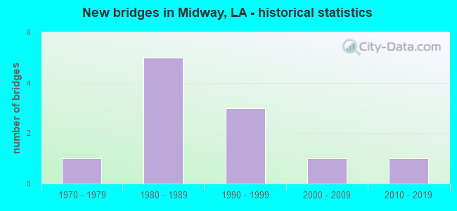
- New bridges - historical statistics
- 11970-1979
- 51980-1989
- 31990-1999
- 12000-2009
- 12010-2019


- Bridge Condition - Deck
- 12.5%Very good
- 62.5%Good
- 25.0%Satisfactory

- Bridge Condition - Superstructure
- 25.0%Very good
- 37.5%Good
- 37.5%Satisfactory

- Bridge Condition - Substructure
- 25.0%Very good
- 25.0%Good
- 37.5%Satisfactory
- 12.5%Poor

- Bridge Condition - Channel
- 45.5%Very good
- 36.4%Good
- 18.2%Satisfactory

- Bridge Condition - Culverts
- 66.7%Very good
- 33.3%Fair
Find on map >> Show street view
Structure Number: 583000000700292, Location: 0.5 Miles North of LA 8 (Lat: 31.677181, Lng: -92.179089), Route carried "on" structure: County highway , Year Built: 2013, Status: Open, Structure Length: 0.73m (2.40ft), Average Daily Traffic: 300 (year 2012), Truck Traffic: 1%, Average Future Daily Traffic: 330 (year 2032), Design Load: HS 20, Features Intersected: TROUT CREEK, Facility Carried by Structure: Sparrow Rd
Minimum Vertical Clearance: 30+ m (98+ ft), Kilometerpoint: 0.000, Lanes on structure: 2, Owner: County Highway Agency, Approaching Roadway Width: 5.5m (18.0ft), Skew: 30 degrees, Material/Design: Concrete, Design/Construction: Culvert, Number Of Spans In Main Unit: 3, Length of Maximum Span: 2.1m (6.9ft)
Condition: Channel: Very good, Culverts: Very good, Operating Rating: 37.9 metric tons, Method Used To Determine Operating Rating: Load and Resistance Factor Rating (LRFR) rating reported by rating factor(RF) method using HL-93 loadings, Inventory Rating: 29.2 metric tons, Method Used To Determine Inventory Rating: Load and Resistance Factor Rating (LRFR) rating reported by rating factor(RF) method using HL-93 loadings, Structural Evaluation: Better than present minimum criteria, Waterway Adequacy: Equal to present desirable criteria, Approach Roadway Alignment: Equal to present minimum criteria, Designated Inspection Frequency: Every 24 months, Inspection Date: Febuary 2020, Deck Structure Type: Concrete Cast-file-Place
Find on map >> Show street view
Structure Number: 583000400408411, Location: .4 MI NORTH OF LA 774 (Lat: 31.658011, Lng: -92.210400), Route carried "on" structure: State highway 8, Year Built: 1972, Status: Open, Structure Length: 3.66m (12.01ft), Average Daily Traffic: 2,800 (year 2016), Truck Traffic: 21%, Average Future Daily Traffic: 1,680 (year 2036), Design Load: HS 20, Features Intersected: CLEAR FORK
Minimum Vertical Clearance: 30+ m (98+ ft), Kilometerpoint: 12.622, Lanes on structure: 2, Owner: State Highway Agency, Approaching Roadway Width: 12.2m (40.0ft), Material/Design: Concrete, Design/Construction: Slab, Number Of Spans In Main Unit: 6, Length of Maximum Span: 6.1m (20.0ft), Curb-To-Curb Width: 12.0m (39.4ft), Out-to-Out Width: 12.7m (41.7ft)
Condition: Deck: Good, Superstructure: Good, Substructure: Good, Channel: Good, Operating Rating: 71.7 metric tons, Method Used To Determine Operating Rating: Load Factor (LF), Inventory Rating: 43.5 metric tons, Method Used To Determine Inventory Rating: Load Factor (LF), Structural Evaluation: Better than present minimum criteria, Deck Geometry: Somewhat better than minimum adequacy, Waterway Adequacy: Equal to present desirable criteria, Approach Roadway Alignment: Equal to present desirable criteria, Designated Inspection Frequency: Every 24 months, Inspection Date: December 2021, Deck Structure Type: Concrete Cast-file-Place
Find on map >> Show street view
Structure Number: 583000400410311, Location: 0.75 M N of LA 8 (Lat: 31.678319, Lng: -92.185400), Route carried "on" structure: State highway 772, Year Built: 1982, Status: Open, Structure Length: 1.77m (5.81ft), Average Daily Traffic: 700 (year 2016), Truck Traffic: 11%, Average Future Daily Traffic: 420 (year 2036), Design Load: HS 20, Features Intersected: TROUT CREEK RELIEF
Minimum Vertical Clearance: 30+ m (98+ ft), Kilometerpoint: 16.110, Lanes on structure: 2, Owner: State Highway Agency, Approaching Roadway Width: 9.1m (29.9ft), Material/Design: Concrete, Design/Construction: Slab, Number Of Spans In Main Unit: 3, Length of Maximum Span: 5.8m (19.0ft), Curb-To-Curb Width: 9.9m (32.5ft), Out-to-Out Width: 11.0m (36.1ft)
Condition: Deck: Good, Superstructure: Good, Substructure: Satisfactory, Channel: Very good, Operating Rating: 65.3 metric tons, Method Used To Determine Operating Rating: Load Factor (LF), Inventory Rating: 39.0 metric tons, Method Used To Determine Inventory Rating: Load Factor (LF), Structural Evaluation: Equal to present minimum criteria, Deck Geometry: Equal to present minimum criteria, Waterway Adequacy: Equal to present desirable criteria, Approach Roadway Alignment: Equal to present desirable criteria, Designated Inspection Frequency: Every 24 months, Inspection Date: October 2020, Deck Structure Type: Concrete Cast-file-Place
Find on map >> Show street view
Structure Number: 583000400410611, Location: 0.75 M N of LA 8 (Lat: 31.678311, Lng: -92.185400), Route carried "on" structure: State highway 772, Year Built: 1982, Status: Open, Structure Length: 2.32m (7.61ft), Average Daily Traffic: 700 (year 2016), Truck Traffic: 11%, Average Future Daily Traffic: 420 (year 2036), Design Load: HS 20, Features Intersected: TROUT CREEK
Minimum Vertical Clearance: 30+ m (98+ ft), Kilometerpoint: 16.108, Lanes on structure: 2, Owner: State Highway Agency, Approaching Roadway Width: 9.1m (29.9ft), Material/Design: Concrete, Design/Construction: Slab, Number Of Spans In Main Unit: 4, Length of Maximum Span: 5.8m (19.0ft), Curb-To-Curb Width: 9.9m (32.5ft), Out-to-Out Width: 11.0m (36.1ft)
Condition: Deck: Satisfactory, Superstructure: Satisfactory, Substructure: Satisfactory, Channel: Very good, Operating Rating: 65.3 metric tons, Method Used To Determine Operating Rating: Load Factor (LF), Inventory Rating: 39.0 metric tons, Method Used To Determine Inventory Rating: Load Factor (LF), Structural Evaluation: Equal to present minimum criteria, Deck Geometry: Equal to present minimum criteria, Approach Roadway Alignment: Equal to present desirable criteria, Designated Inspection Frequency: Every 24 months, Inspection Date: October 2020, Deck Structure Type: Concrete Cast-file-Place
Find on map >> Show street view
Structure Number: 583001490502191, Location: 2.2 MI NORTH OF LA 460 (Lat: 31.616989, Lng: -92.144900), Route carried "on" structure: State highway 127, Year Built: 1995, Status: Open, Structure Length: 3.47m (11.38ft), Average Daily Traffic: 1,520 (year 2016), Truck Traffic: 21%, Average Future Daily Traffic: 786 (year 2036), Design Load: HS 20, Features Intersected: CREEK
Minimum Vertical Clearance: 30+ m (98+ ft), Kilometerpoint: 3.494, Lanes on structure: 2, Owner: State Highway Agency, Approaching Roadway Width: 8.8m (28.9ft), Material/Design: Concrete, Design/Construction: Slab, Number Of Spans In Main Unit: 6, Length of Maximum Span: 5.8m (19.0ft), Curb-To-Curb Width: 8.8m (28.9ft), Out-to-Out Width: 10.5m (34.4ft)
Condition: Deck: Very good, Superstructure: Very good, Substructure: Very good, Channel: Very good, Operating Rating: 89.8 metric tons, Method Used To Determine Operating Rating: Load Factor (LF), Inventory Rating: 58.0 metric tons, Method Used To Determine Inventory Rating: Load Factor (LF), Structural Evaluation: Equal to present desirable criteria, Deck Geometry: Somewhat better than minimum adequacy, Waterway Adequacy: Equal to present desirable criteria, Approach Roadway Alignment: Somewhat better than minimum adequacy, Designated Inspection Frequency: Every 24 months, Inspection Date: January 2021, Deck Structure Type: Concrete Cast-file-Place
Find on map >> Show street view
Structure Number: 583008300900501, Location: .5 MI NORTH OF LA 774 (Lat: 31.637500, Lng: -92.191800), Route carried "on" structure: State highway 773, Year Built: 1981, Status: Open, Structure Length: 1.74m (5.71ft), Average Daily Traffic: 1,680 (year 2016), Truck Traffic: 15%, Average Future Daily Traffic: 930 (year 2036), Design Load: HS 20, Features Intersected: CREEK
Minimum Vertical Clearance: 30+ m (98+ ft), Kilometerpoint: 0.795, Lanes on structure: 2, Owner: State Highway Agency, Approaching Roadway Width: 8.2m (26.9ft), Material/Design: Concrete, Design/Construction: Slab, Number Of Spans In Main Unit: 3, Length of Maximum Span: 5.8m (19.0ft), Curb-To-Curb Width: 9.8m (32.2ft), Out-to-Out Width: 11.0m (36.1ft)
Condition: Deck: Good, Superstructure: Satisfactory, Substructure: Satisfactory, Channel: Very good, Operating Rating: 65.3 metric tons, Method Used To Determine Operating Rating: Load Factor (LF), Inventory Rating: 39.0 metric tons, Method Used To Determine Inventory Rating: Load Factor (LF), Structural Evaluation: Equal to present minimum criteria, Deck Geometry: Somewhat better than minimum adequacy, Waterway Adequacy: Equal to present desirable criteria, Approach Roadway Alignment: Equal to present desirable criteria, Designated Inspection Frequency: Every 24 months, Inspection Date: November 2021, Deck Structure Type: Concrete Cast-file-Place
Find on map >> Show street view
Structure Number: 583008300902401, Location: 2.4 MI NORTH OF LA 774 (Lat: 31.659319, Lng: -92.177600), Route carried "on" structure: State highway 773, Year Built: 1981, Status: Open, Structure Length: 1.74m (5.71ft), Average Daily Traffic: 1,680 (year 2016), Truck Traffic: 15%, Average Future Daily Traffic: 930 (year 2036), Design Load: HS 20, Features Intersected: CREEK
Minimum Vertical Clearance: 30+ m (98+ ft), Kilometerpoint: 3.813, Lanes on structure: 2, Owner: State Highway Agency, Approaching Roadway Width: 8.2m (26.9ft), Material/Design: Concrete, Design/Construction: Slab, Number Of Spans In Main Unit: 3, Length of Maximum Span: 5.8m (19.0ft), Curb-To-Curb Width: 9.8m (32.2ft), Out-to-Out Width: 11.0m (36.1ft)
Condition: Deck: Good, Superstructure: Good, Substructure: Good, Channel: Good, Operating Rating: 65.3 metric tons, Method Used To Determine Operating Rating: Load Factor (LF), Inventory Rating: 39.0 metric tons, Method Used To Determine Inventory Rating: Load Factor (LF), Structural Evaluation: Better than present minimum criteria, Deck Geometry: Somewhat better than minimum adequacy, Waterway Adequacy: Equal to present desirable criteria, Approach Roadway Alignment: Better than present minimum criteria, Designated Inspection Frequency: Every 24 months, Inspection Date: November 2021, Deck Structure Type: Concrete Cast-file-Place
Find on map >> Show street view
Structure Number: 583031360920821, Location: 0.35 LOG FR 127 TO ODE (Lat: 31.614081, Lng: -92.140861), Route carried "on" structure: County highway , Year Built: 1990, Status: Posted for load, Structure Length: 1.28m (4.20ft), Average Daily Traffic: 20 (year 2016), Average Future Daily Traffic: 12 (year 2036), Design Load: H 10, Features Intersected: MILL CREEK, Facility Carried by Structure: Arlies Lane
Minimum Vertical Clearance: 30+ m (98+ ft), Kilometerpoint: 0.000, Lanes on structure: 1, Base Highway Network: Yes, Owner: County Highway Agency, Approaching Roadway Width: 4.0m (13.1ft), Material/Design: Wood or Timber, Design/Construction: Stringer/Multi-beam, Number Of Spans In Main Unit: 3, Length of Maximum Span: 4.9m (16.1ft), Curb-To-Curb Width: 4.5m (14.8ft), Out-to-Out Width: 4.9m (16.1ft)
Condition: Deck: Satisfactory, Superstructure: Satisfactory, Substructure: Poor, Channel: Satisfactory, Operating Rating: 20.0 metric tons, Method Used To Determine Operating Rating: Allowable Stress (AS), Inventory Rating: 13.6 metric tons, Method Used To Determine Inventory Rating: Allowable Stress (AS), Structural Evaluation: Meets minimum limits, Deck Geometry: Equal to present minimum criteria, Waterway Adequacy: Somewhat better than minimum adequacy, Approach Roadway Alignment: Meets minimum limits, Bridge Posting: Required (Relationship of Operating Rating to Maximum Legal Load: > 39.9% below), Length Of Structure Improvement: 1.95m (6.40ft), Designated Inspection Frequency: Every 24 months, Other Special Inspection Frequency: Every 12 months, Inspection Date: July 2021, Other Special Inspection Date: January 2021, Bridge Improvement Cost: $116,000, Total Project Cost: $174,000 ( Estimate for 2016), Deck Structure Type: Wood or Timber, Wearing Surface/Protective System: Wearing Surface: Other
Find on map >> Show street view
Structure Number: 583031398921011, Location: 0.8 MILES SOUTH OF LA 8 (Lat: 31.663331, Lng: -92.168300), Route carried "on" structure: County highway , Year Built: 1984, Status: Open, Structure Length: 0.98m (3.22ft), Average Daily Traffic: 70 (year 1973), Average Future Daily Traffic: 42 (year 2036), Design Load: HS 20, Features Intersected: MUDDY PRONG, Facility Carried by Structure: Tingle Rd
Minimum Vertical Clearance: 30+ m (98+ ft), Kilometerpoint: 0.000, Lanes on structure: 2, Owner: County Highway Agency, Approaching Roadway Width: 6.1m (20.0ft), Skew: 30 degrees, Material/Design: Steel, Design/Construction: Culvert, Number Of Spans In Main Unit: 3, Length of Maximum Span: 2.1m (6.9ft)
Condition: Channel: Good, Culverts: Fair, Operating Rating: 97.2 metric tons, Method Used To Determine Operating Rating: Load and Resistance Factor Rating (LRFR) rating reported by rating factor(RF) method using HL-93 loadings, Inventory Rating: 74.5 metric tons, Method Used To Determine Inventory Rating: Load and Resistance Factor Rating (LRFR) rating reported by rating factor(RF) method using HL-93 loadings, Structural Evaluation: Somewhat better than minimum adequacy, Waterway Adequacy: Somewhat better than minimum adequacy, Approach Roadway Alignment: Equal to present minimum criteria, Designated Inspection Frequency: Every 24 months, Inspection Date: Febuary 2020
Find on map >> Show street view
Structure Number: 583031423921201, Location: 0.1 Mi N of McClendon Ln (Lat: 31.703039, Lng: -92.196811), Route carried "on" structure: County highway , Year Built: 2006, Status: Open, Structure Length: 0.98m (3.22ft), Average Daily Traffic: 200 (year 2020), Average Future Daily Traffic: 220 (year 2040), Design Load: HS 20, Features Intersected: STUMP ROAD CREEK, Facility Carried by Structure: Stump Rd
Minimum Vertical Clearance: 30+ m (98+ ft), Kilometerpoint: 0.000, Lanes on structure: 2, Owner: County Highway Agency, Approaching Roadway Width: 5.8m (19.0ft), Material/Design: Concrete, Design/Construction: Culvert, Number Of Spans In Main Unit: 4, Length of Maximum Span: 2.1m (6.9ft)
Condition: Channel: Good, Culverts: Very good, Operating Rating: 40.2 metric tons, Method Used To Determine Operating Rating: Load and Resistance Factor Rating (LRFR) rating reported by rating factor(RF) method using HL-93 loadings, Inventory Rating: 31.1 metric tons, Method Used To Determine Inventory Rating: Load and Resistance Factor Rating (LRFR) rating reported by rating factor(RF) method using HL-93 loadings, Structural Evaluation: Better than present minimum criteria, Waterway Adequacy: Meets minimum limits, Approach Roadway Alignment: Somewhat better than minimum adequacy, Designated Inspection Frequency: Every 24 months, Inspection Date: Febuary 2020, Deck Structure Type: Concrete Cast-file-Place
Find on map >> Show street view
Structure Number: 583031474920511, Location: LOGMI 0.48 FR 460 TO 435 (Lat: 31.660111, Lng: -92.217739), Route carried "on" structure: County highway , Year Built: 1997, Status: Open, Structure Length: 2.32m (7.61ft), Average Daily Traffic: 50 (year 1973), Average Future Daily Traffic: 30 (year 2036), Design Load: HS 20, Features Intersected: FUNNY LOUIS BAYOU, Facility Carried by Structure: Reeves Cutoff
Minimum Vertical Clearance: 30+ m (98+ ft), Kilometerpoint: 0.000, Lanes on structure: 2, Base Highway Network: Yes, Owner: County Highway Agency, Approaching Roadway Width: 8.2m (26.9ft), Material/Design: Concrete, Design/Construction: Slab, Number Of Spans In Main Unit: 4, Length of Maximum Span: 5.8m (19.0ft), Curb-To-Curb Width: 7.4m (24.3ft), Out-to-Out Width: 8.2m (26.9ft)
Condition: Deck: Good, Superstructure: Very good, Substructure: Very good, Channel: Satisfactory, Operating Rating: 33.7 metric tons, Method Used To Determine Operating Rating: Load and Resistance Factor Rating (LRFR) rating reported by rating factor(RF) method using HL-93 loadings, Inventory Rating: 25.9 metric tons, Method Used To Determine Inventory Rating: Load and Resistance Factor Rating (LRFR) rating reported by rating factor(RF) method using HL-93 loadings, Structural Evaluation: Equal to present minimum criteria, Deck Geometry: Equal to present minimum criteria, Waterway Adequacy: Equal to present desirable criteria, Approach Roadway Alignment: Equal to present desirable criteria, Designated Inspection Frequency: Every 24 months, Inspection Date: January 2022, Deck Structure Type: Concrete Cast-file-Place, Wearing Surface/Protective System: Wearing Surface: Monolithic Concrete