Bridge Statistics for Midway, Texas (TX)
Condition, Traffic, Stress, Structural Evaluation, Project Costs
- National Bridge Inventory (NBI) Statistics
- 16Number of bridges
- 105ft / 31.8mTotal length
- $330,000Total costs
- 34,786Total average daily traffic
- 5,428Total average daily truck traffic
- 50,165Total future (year 2037) average daily traffic
- National Bridge Inventory (NBI) Registered Bridges for Midway
- No street view available for this location
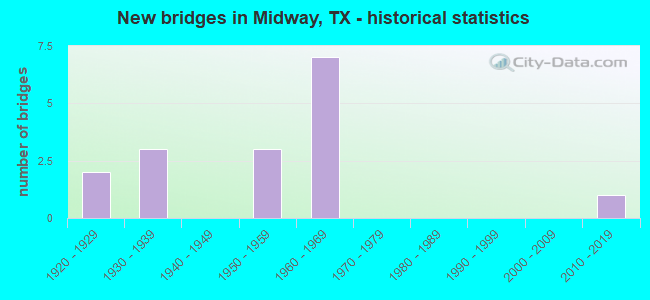
- New bridges - historical statistics
- 21920-1929
- 31930-1939
- 31950-1959
- 71960-1969
- 12010-2019

- Reconstructed bridges - Historical Statistics
- 31960-1969
- 01970-1979
- 11980-1989
- 11990-1999
- 12000-2009
- 22010-2019


- Bridge Condition - Deck
- 14.3%Very good
- 57.1%Good
- 28.6%Satisfactory

- Bridge Condition - Superstructure
- 14.3%Very good
- 71.4%Good
- 14.3%Satisfactory

- Bridge Condition - Substructure
- 28.6%Good
- 71.4%Satisfactory

- Bridge Condition - Channel
- 25.0%Good
- 56.3%Satisfactory
- 18.8%Fair

- Bridge Condition - Culverts
- 22.2%Good
- 66.7%Satisfactory
- 11.1%Fair
Find on map >> Show street view
Structure Number: 171540011705031, Location: 2.7 MI NE OF FM 1428 (Lat: 30.996989, Lng: -95.800000), Route carried "on" structure: State highway 21, Year Built: 1927, Year Reconstructed: 1968, Status: Open, Structure Length: 1.04m (3.41ft), Average Daily Traffic: 4,991 (year 2020), Truck Traffic: 15%, Average Future Daily Traffic: 7,184 (year 2039), Design Load: H 15, Features Intersected: LARRISON CREEK RELIEF
Minimum Vertical Clearance: 30+ m (98+ ft), Kilometerpoint: 42.237, Lanes on structure: 2, Base Highway Network: Yes, Owner: State Highway Agency, Approaching Roadway Width: 13.4m (44.0ft), Material/Design: Concrete, Design/Construction: Culvert, Number Of Spans In Main Unit: 4, Length of Maximum Span: 2.4m (7.9ft), Curb-To-Curb Width: 13.6m (44.6ft), Out-to-Out Width: 14.9m (48.9ft)
Condition: Channel: Good, Culverts: Satisfactory, Operating Rating: 39.9 metric tons, Method Used To Determine Operating Rating: Load Factor (LF), Inventory Rating: 23.6 metric tons, Method Used To Determine Inventory Rating: Load Factor (LF), Structural Evaluation: Equal to present minimum criteria, Deck Geometry: Superior to present desirable criteria, Waterway Adequacy: Equal to present minimum criteria, Approach Roadway Alignment: Equal to present desirable criteria, Designated Inspection Frequency: Every 24 months, Inspection Date: June 2021, Deck Structure Type: Concrete Cast-file-Place, Wearing Surface/Protective System: Wearing Surface: Bituminous
Find on map >> Show street view
Structure Number: 171540011705035, Location: 1.75 MI NE OF FM 247 (Lat: 31.045003, Lng: -95.731367), Route carried "on" structure: State highway 21, Year Built: 1930, Year Reconstructed: 1968, Status: Open, Structure Length: 0.64m (2.10ft), Average Daily Traffic: 2,560 (year 2020), Truck Traffic: 20%, Average Future Daily Traffic: 3,755 (year 2039), Design Load: H 15, Features Intersected: IVEY CREEK
Minimum Vertical Clearance: 30+ m (98+ ft), Kilometerpoint: 50.838, Lanes on structure: 2, Base Highway Network: Yes, Owner: State Highway Agency, Approaching Roadway Width: 13.7m (44.9ft), Material/Design: Concrete, Design/Construction: Culvert, Number Of Spans In Main Unit: 2, Length of Maximum Span: 3.0m (9.8ft), Curb-To-Curb Width: 14.1m (46.3ft), Out-to-Out Width: 16.5m (54.1ft)
Condition: Channel: Fair, Culverts: Satisfactory, Operating Rating: 39.9 metric tons, Method Used To Determine Operating Rating: Load Factor (LF), Inventory Rating: 23.6 metric tons, Method Used To Determine Inventory Rating: Load Factor (LF), Structural Evaluation: Equal to present minimum criteria, Deck Geometry: Superior to present desirable criteria, Waterway Adequacy: Equal to present minimum criteria, Approach Roadway Alignment: Equal to present desirable criteria, Designated Inspection Frequency: Every 24 months, Inspection Date: June 2021, Deck Structure Type: Concrete Cast-file-Place, Wearing Surface/Protective System: Wearing Surface: Bituminous
Find on map >> Show street view
Structure Number: 171540011705036, Location: 1.9 MI NE OF FM 247 (Lat: 31.046717, Lng: -95.730253), Route carried "on" structure: State highway 21, Year Built: 1930, Year Reconstructed: 1968, Status: Open, Structure Length: 0.67m (2.20ft), Average Daily Traffic: 2,560 (year 2020), Truck Traffic: 20%, Average Future Daily Traffic: 3,755 (year 2039), Design Load: H 15, Features Intersected: CEDAR LAKE BRANCH
Minimum Vertical Clearance: 30+ m (98+ ft), Kilometerpoint: 51.069, Lanes on structure: 2, Base Highway Network: Yes, Owner: State Highway Agency, Approaching Roadway Width: 13.7m (44.9ft), Material/Design: Concrete, Design/Construction: Culvert, Number Of Spans In Main Unit: 2, Length of Maximum Span: 3.0m (9.8ft), Curb-To-Curb Width: 13.9m (45.6ft), Out-to-Out Width: 16.0m (52.5ft)
Condition: Channel: Satisfactory, Culverts: Fair, Operating Rating: 39.9 metric tons, Method Used To Determine Operating Rating: Load Factor (LF), Inventory Rating: 23.6 metric tons, Method Used To Determine Inventory Rating: Load Factor (LF), Structural Evaluation: Somewhat better than minimum adequacy, Deck Geometry: Superior to present desirable criteria, Waterway Adequacy: Equal to present minimum criteria, Approach Roadway Alignment: Equal to present desirable criteria, Designated Inspection Frequency: Every 24 months, Inspection Date: June 2021, Deck Structure Type: Concrete Cast-file-Place, Wearing Surface/Protective System: Wearing Surface: Bituminous
Find on map >> Show street view
Structure Number: 171540011705037, Location: 2.4 MI NE OF FM 247 (Lat: 31.052711, Lng: -95.725814), Route carried "on" structure: State highway 21, Year Built: 1930, Year Reconstructed: 2016, Status: Open, Structure Length: 1.07m (3.51ft), Average Daily Traffic: 2,560 (year 2020), Truck Traffic: 20%, Average Future Daily Traffic: 3,755 (year 2039), Design Load: H 15, Features Intersected: YOUNGS CREEK
Minimum Vertical Clearance: 30+ m (98+ ft), Kilometerpoint: 51.839, Lanes on structure: 3, Base Highway Network: Yes, Owner: State Highway Agency, Approaching Roadway Width: 15.7m (51.5ft), Material/Design: Concrete, Design/Construction: Culvert, Number Of Spans In Main Unit: 4, Length of Maximum Span: 2.4m (7.9ft), Curb-To-Curb Width: 15.7m (51.5ft), Out-to-Out Width: 18.3m (60.0ft)
Condition: Channel: Good, Culverts: Satisfactory, Operating Rating: 39.9 metric tons, Method Used To Determine Operating Rating: Load Factor (LF), Inventory Rating: 23.6 metric tons, Method Used To Determine Inventory Rating: Load Factor (LF), Structural Evaluation: Equal to present minimum criteria, Deck Geometry: Better than present minimum criteria, Waterway Adequacy: Equal to present minimum criteria, Approach Roadway Alignment: Equal to present desirable criteria, Designated Inspection Frequency: Every 24 months, Inspection Date: June 2021, Deck Structure Type: Concrete Cast-file-Place, Wearing Surface/Protective System: Wearing Surface: Bituminous
Find on map >> Show street view
Structure Number: 171540011705057, Location: 4.2 MI E OF FM 1428 (Lat: 31.006789, Lng: -95.776181), Route carried "on" structure: State highway 21, Year Built: 1926, Year Reconstructed: 2002, Status: Open, Structure Length: 0.64m (2.10ft), Average Daily Traffic: 4,991 (year 2020), Truck Traffic: 15%, Average Future Daily Traffic: 7,184 (year 2039), Features Intersected: DRAW
Minimum Vertical Clearance: 30+ m (98+ ft), Kilometerpoint: 44.777, Lanes on structure: 2, Base Highway Network: Yes, Owner: State Highway Agency, Approaching Roadway Width: 14.6m (47.9ft), Skew: 9 degrees, Material/Design: Concrete, Design/Construction: Culvert, Number Of Spans In Main Unit: 2, Length of Maximum Span: 3.0m (9.8ft), Curb-To-Curb Width: 14.6m (47.9ft), Out-to-Out Width: 25.8m (84.6ft)
Condition: Channel: Fair, Culverts: Satisfactory, Operating Rating: 39.9 metric tons, Method Used To Determine Operating Rating: Load Factor (LF), Inventory Rating: 23.6 metric tons, Method Used To Determine Inventory Rating: Load Factor (LF), Structural Evaluation: Equal to present minimum criteria, Deck Geometry: Superior to present desirable criteria, Waterway Adequacy: Equal to present minimum criteria, Approach Roadway Alignment: Equal to present desirable criteria, Designated Inspection Frequency: Every 24 months, Inspection Date: June 2021
Find on map >> Show street view
Structure Number: 17154001170508, Location: 3.01 MI NE OF FM 1428 (Lat: 30.998125, Lng: -95.797350), Route carried "on" structure: State highway 21, Year Built: 1968, Status: Open, Structure Length: 4.88m (16.01ft), Average Daily Traffic: 4,991 (year 2020), Truck Traffic: 15%, Average Future Daily Traffic: 7,184 (year 2039), Design Load: H 20, Features Intersected: LARRISON CREEK
Minimum Vertical Clearance: 30+ m (98+ ft), Kilometerpoint: 42.477, Lanes on structure: 2, Base Highway Network: Yes, Owner: State Highway Agency, Approaching Roadway Width: 13.7m (44.9ft), Material/Design: Concrete, Design/Construction: Stringer/Multi-beam, Number Of Spans In Main Unit: 4, Length of Maximum Span: 12.2m (40.0ft), Curb-To-Curb Width: 13.4m (44.0ft), Out-to-Out Width: 14.1m (46.3ft)
Condition: Deck: Good, Superstructure: Good, Substructure: Satisfactory, Channel: Satisfactory, Operating Rating: 47.2 metric tons, Method Used To Determine Operating Rating: Load Factor (LF), Inventory Rating: 29.0 metric tons, Method Used To Determine Inventory Rating: Load Factor (LF), Structural Evaluation: Equal to present minimum criteria, Deck Geometry: Better than present minimum criteria, Waterway Adequacy: Equal to present minimum criteria, Approach Roadway Alignment: Equal to present desirable criteria, Designated Inspection Frequency: Every 24 months, Inspection Date: June 2021, Deck Structure Type: Concrete Cast-file-Place, Wearing Surface/Protective System: Wearing Surface: Bituminous
Find on map >> Show street view
Structure Number: 171540011705081, Location: 3.22 MI NE OF FM 1428 (Lat: 30.999139, Lng: -95.794461), Route carried "on" structure: State highway 21, Year Built: 1968, Status: Open, Structure Length: 3.66m (12.01ft), Average Daily Traffic: 4,991 (year 2020), Truck Traffic: 15%, Average Future Daily Traffic: 7,184 (year 2039), Design Load: H 20, Features Intersected: LARRISON CRK RELIEF NO 1
Minimum Vertical Clearance: 30+ m (98+ ft), Kilometerpoint: 42.815, Lanes on structure: 2, Base Highway Network: Yes, Owner: State Highway Agency, Approaching Roadway Width: 13.7m (44.9ft), Material/Design: Concrete, Design/Construction: Stringer/Multi-beam, Number Of Spans In Main Unit: 3, Length of Maximum Span: 12.2m (40.0ft), Curb-To-Curb Width: 13.4m (44.0ft), Out-to-Out Width: 14.1m (46.3ft)
Condition: Deck: Good, Superstructure: Good, Substructure: Satisfactory, Channel: Satisfactory, Operating Rating: 47.2 metric tons, Method Used To Determine Operating Rating: Load Factor (LF), Inventory Rating: 28.1 metric tons, Method Used To Determine Inventory Rating: Load Factor (LF), Structural Evaluation: Equal to present minimum criteria, Deck Geometry: Better than present minimum criteria, Waterway Adequacy: Equal to present minimum criteria, Approach Roadway Alignment: Equal to present desirable criteria, Designated Inspection Frequency: Every 24 months, Inspection Date: June 2021, Deck Structure Type: Concrete Cast-file-Place, Wearing Surface/Protective System: Wearing Surface: Bituminous
Find on map >> Show street view
Structure Number: 171540011705082, Location: 3.38 MI NE OF FM 1428 (Lat: 31.000078, Lng: -95.792072), Route carried "on" structure: State highway 21, Year Built: 1968, Status: Open, Structure Length: 3.66m (12.01ft), Average Daily Traffic: 4,991 (year 2020), Truck Traffic: 15%, Average Future Daily Traffic: 7,184 (year 2039), Design Load: H 20, Features Intersected: LARRISON CRK RELIEF NO 2
Minimum Vertical Clearance: 30+ m (98+ ft), Kilometerpoint: 43.064, Lanes on structure: 2, Base Highway Network: Yes, Owner: State Highway Agency, Approaching Roadway Width: 13.4m (44.0ft), Material/Design: Concrete, Design/Construction: Stringer/Multi-beam, Number Of Spans In Main Unit: 3, Length of Maximum Span: 12.2m (40.0ft), Curb-To-Curb Width: 13.4m (44.0ft), Out-to-Out Width: 14.1m (46.3ft)
Condition: Deck: Satisfactory, Superstructure: Good, Substructure: Satisfactory, Channel: Satisfactory, Operating Rating: 49.0 metric tons, Method Used To Determine Operating Rating: Load Factor (LF), Inventory Rating: 29.9 metric tons, Method Used To Determine Inventory Rating: Load Factor (LF), Structural Evaluation: Equal to present minimum criteria, Deck Geometry: Better than present minimum criteria, Waterway Adequacy: Equal to present minimum criteria, Approach Roadway Alignment: Equal to present desirable criteria, Designated Inspection Frequency: Every 24 months, Inspection Date: June 2021, Deck Structure Type: Concrete Cast-file-Place, Wearing Surface/Protective System: Wearing Surface: Bituminous
Find on map >> Show street view
Structure Number: 171540057804016, Location: 0.95 MI N OF SH 21 (Lat: 31.043042, Lng: -95.743456), Route carried "on" structure: State highway 3060, Year Built: 1968, Year Reconstructed: 2012, Status: Open, Structure Length: 0.64m (2.10ft), Average Daily Traffic: 336 (year 2020), Truck Traffic: 3%, Average Future Daily Traffic: 383 (year 2039), Design Load: HS 20, Features Intersected: IVEY CREEK
Minimum Vertical Clearance: 30+ m (98+ ft), Kilometerpoint: 1.764, Lanes on structure: 2, Owner: State Highway Agency, Approaching Roadway Width: 7.9m (25.9ft), Material/Design: Concrete, Design/Construction: Culvert, Number Of Spans In Main Unit: 2, Length of Maximum Span: 3.0m (9.8ft), Curb-To-Curb Width: 13.4m (44.0ft), Out-to-Out Width: 14.0m (45.9ft)
Condition: Channel: Satisfactory, Culverts: Satisfactory, Operating Rating: 39.9 metric tons, Method Used To Determine Operating Rating: Load Factor (LF), Inventory Rating: 23.6 metric tons, Method Used To Determine Inventory Rating: Load Factor (LF), Structural Evaluation: Equal to present minimum criteria, Deck Geometry: Superior to present desirable criteria, Waterway Adequacy: Equal to present minimum criteria, Approach Roadway Alignment: Somewhat better than minimum adequacy, Designated Inspection Frequency: Every 24 months, Inspection Date: June 2021, Deck Structure Type: Concrete Cast-file-Place, Wearing Surface/Protective System: Wearing Surface: Bituminous
Find on map >> Show street view
Structure Number: 171540057804017, Location: 1.65 MI N OF SH 21 (Lat: 31.052775, Lng: -95.742314), Route carried "on" structure: State highway 3060, Year Built: 1968, Status: Open, Structure Length: 1.16m (3.81ft), Average Daily Traffic: 336 (year 2020), Truck Traffic: 3%, Average Future Daily Traffic: 383 (year 2039), Design Load: HS 20, Features Intersected: PETITT CK(CEDAR LAKE BR)
Minimum Vertical Clearance: 30+ m (98+ ft), Kilometerpoint: 0.665, Lanes on structure: 2, Owner: State Highway Agency, Approaching Roadway Width: 7.9m (25.9ft), Material/Design: Concrete, Design/Construction: Culvert, Number Of Spans In Main Unit: 4, Length of Maximum Span: 2.7m (8.9ft), Curb-To-Curb Width: 9.4m (30.8ft), Out-to-Out Width: 10.2m (33.5ft)
Condition: Channel: Satisfactory, Culverts: Satisfactory, Operating Rating: 39.9 metric tons, Method Used To Determine Operating Rating: Load Factor (LF), Inventory Rating: 23.6 metric tons, Method Used To Determine Inventory Rating: Load Factor (LF), Structural Evaluation: Equal to present minimum criteria, Deck Geometry: Equal to present minimum criteria, Waterway Adequacy: Equal to present minimum criteria, Approach Roadway Alignment: Equal to present desirable criteria, Designated Inspection Frequency: Every 24 months, Inspection Date: June 2021, Deck Structure Type: Concrete Cast-file-Place, Wearing Surface/Protective System: Wearing Surface: Bituminous
Find on map >> Show street view
Structure Number: 171540122302006, Location: 1.5 MI N OF OSR (Lat: 31.072211, Lng: -95.804336), Route carried "on" structure: State highway 1119, Year Built: 1955, Year Reconstructed: 2017, Status: Open, Structure Length: 0.64m (2.10ft), Average Daily Traffic: 400 (year 2020), Truck Traffic: 10%, Average Future Daily Traffic: 601 (year 2039), Features Intersected: YOUNGS CREEK
Minimum Vertical Clearance: 30+ m (98+ ft), Kilometerpoint: 2.601, Lanes on structure: 2, Owner: State Highway Agency, Approaching Roadway Width: 9.9m (32.5ft), Material/Design: Concrete, Design/Construction: Culvert, Number Of Spans In Main Unit: 2, Length of Maximum Span: 3.0m (9.8ft), Curb-To-Curb Width: 9.9m (32.5ft), Out-to-Out Width: 12.8m (42.0ft)
Condition: Channel: Satisfactory, Culverts: Good, Operating Rating: 39.9 metric tons, Method Used To Determine Operating Rating: Load Factor (LF), Inventory Rating: 23.6 metric tons, Method Used To Determine Inventory Rating: Load Factor (LF), Structural Evaluation: Equal to present minimum criteria, Deck Geometry: Better than present minimum criteria, Waterway Adequacy: Equal to present minimum criteria, Approach Roadway Alignment: Somewhat better than minimum adequacy, Designated Inspection Frequency: Every 24 months, Inspection Date: June 2021, Deck Structure Type: Concrete Cast-file-Place, Wearing Surface/Protective System: Wearing Surface: Bituminous
Find on map >> Show street view
Structure Number: 171540122303007, Location: 0.65 MI S OF OSR (Lat: 31.046297, Lng: -95.822508), Route carried "on" structure: State highway 2346, Year Built: 1957, Year Reconstructed: 1993, Status: Open, Structure Length: 0.70m (2.30ft), Average Daily Traffic: 548 (year 2020), Truck Traffic: 8%, Average Future Daily Traffic: 692 (year 2039), Features Intersected: PERSON BRANCH
Minimum Vertical Clearance: 30+ m (98+ ft), Kilometerpoint: 1.032, Lanes on structure: 2, Owner: State Highway Agency, Approaching Roadway Width: 7.9m (25.9ft), Skew: 3 degrees, Material/Design: Concrete, Design/Construction: Culvert, Number Of Spans In Main Unit: 3, Length of Maximum Span: 1.8m (5.9ft), Curb-To-Curb Width: 13.3m (43.6ft), Out-to-Out Width: 14.0m (45.9ft)
Condition: Channel: Fair, Culverts: Good, Operating Rating: 39.9 metric tons, Method Used To Determine Operating Rating: Load Factor (LF), Inventory Rating: 23.6 metric tons, Method Used To Determine Inventory Rating: Load Factor (LF), Structural Evaluation: Equal to present minimum criteria, Deck Geometry: Superior to present desirable criteria, Waterway Adequacy: Equal to present minimum criteria, Approach Roadway Alignment: Meets minimum limits, Designated Inspection Frequency: Every 24 months, Inspection Date: June 2021, Deck Structure Type: Concrete Cast-file-Place, Wearing Surface/Protective System: Wearing Surface: Bituminous
Find on map >> Show street view
Structure Number: 171540202701001, Location: 2.65 MI S OF SH 21 (Lat: 30.981000, Lng: -95.771542), Route carried "on" structure: State highway 2158, Year Built: 1955, Status: Open, Structure Length: 3.05m (10.01ft), Average Daily Traffic: 124 (year 2020), Truck Traffic: 13%, Average Future Daily Traffic: 234 (year 2039), Features Intersected: LARRISON CREEK
Minimum Vertical Clearance: 30+ m (98+ ft), Kilometerpoint: 12.294, Lanes on structure: 2, Owner: State Highway Agency, Approaching Roadway Width: 7.3m (24.0ft), Material/Design: Concrete, Design/Construction: Slab, Number Of Spans In Main Unit: 4, Length of Maximum Span: 7.6m (24.9ft), Curb-To-Curb Width: 7.1m (23.3ft), Out-to-Out Width: 7.7m (25.3ft)
Condition: Deck: Satisfactory, Superstructure: Satisfactory, Substructure: Satisfactory, Channel: Good, Operating Rating: 44.4 metric tons, Method Used To Determine Operating Rating: Load Factor (LF), Inventory Rating: 30.8 metric tons, Method Used To Determine Inventory Rating: Load Factor (LF), Structural Evaluation: Equal to present minimum criteria, Deck Geometry: Meets minimum limits, Waterway Adequacy: Equal to present minimum criteria, Approach Roadway Alignment: Somewhat better than minimum adequacy, Length Of Structure Improvement: 3.96m (12.99ft), Designated Inspection Frequency: Every 24 months, Inspection Date: June 2021, Bridge Improvement Cost: $220,000, Roadway Improvement Cost: $22,000, Total Project Cost: $330,000, Deck Structure Type: Concrete Cast-file-Place
Find on map >> Show street view
Structure Number: 171540254801001, Location: 2.1 MI E OF SH 21 (Lat: 31.030717, Lng: -95.711197), Route carried "on" structure: State highway 2548, Year Built: 1960, Status: Open, Structure Length: 3.05m (10.01ft), Average Daily Traffic: 187 (year 2020), Truck Traffic: 12%, Average Future Daily Traffic: 335 (year 2039), Features Intersected: YOUNGS CREEK
Minimum Vertical Clearance: 30+ m (98+ ft), Kilometerpoint: 15.334, Lanes on structure: 2, Owner: State Highway Agency, Approaching Roadway Width: 7.3m (24.0ft), Material/Design: Concrete, Design/Construction: Slab, Number Of Spans In Main Unit: 4, Length of Maximum Span: 7.6m (24.9ft), Curb-To-Curb Width: 7.1m (23.3ft), Out-to-Out Width: 7.7m (25.3ft)
Condition: Deck: Good, Superstructure: Good, Substructure: Good, Channel: Satisfactory, Operating Rating: 44.4 metric tons, Method Used To Determine Operating Rating: Load Factor (LF), Inventory Rating: 27.2 metric tons, Method Used To Determine Inventory Rating: Load Factor (LF), Structural Evaluation: Equal to present minimum criteria, Deck Geometry: Meets minimum limits, Waterway Adequacy: Equal to present minimum criteria, Approach Roadway Alignment: Equal to present minimum criteria, Designated Inspection Frequency: Every 24 months, Inspection Date: June 2021, Deck Structure Type: Concrete Cast-file-Place, Wearing Surface/Protective System: Wearing Surface: Bituminous
Find on map >> Show street view
Structure Number: 171540254801002, Location: 2.85 MI E OF SH 21 (Lat: 31.034717, Lng: -95.699503), Route carried "on" structure: State highway 2548, Year Built: 1960, Status: Open, Structure Length: 3.81m (12.50ft), Average Daily Traffic: 100 (year 2020), Truck Traffic: 11%, Average Future Daily Traffic: 202 (year 2039), Features Intersected: DRAW
Minimum Vertical Clearance: 30+ m (98+ ft), Kilometerpoint: 14.146, Lanes on structure: 2, Owner: State Highway Agency, Approaching Roadway Width: 7.3m (24.0ft), Material/Design: Concrete, Design/Construction: Slab, Number Of Spans In Main Unit: 5, Length of Maximum Span: 7.6m (24.9ft), Curb-To-Curb Width: 7.3m (24.0ft), Out-to-Out Width: 7.7m (25.3ft)
Condition: Deck: Good, Superstructure: Good, Substructure: Satisfactory, Channel: Satisfactory, Operating Rating: 44.4 metric tons, Method Used To Determine Operating Rating: Load Factor (LF), Inventory Rating: 27.2 metric tons, Method Used To Determine Inventory Rating: Load Factor (LF), Structural Evaluation: Equal to present minimum criteria, Deck Geometry: Equal to present minimum criteria, Waterway Adequacy: Equal to present minimum criteria, Approach Roadway Alignment: Equal to present desirable criteria, Designated Inspection Frequency: Every 24 months, Inspection Date: June 2021, Deck Structure Type: Concrete Cast-file-Place, Wearing Surface/Protective System: Wearing Surface: Bituminous
Find on map >> Show street view
Structure Number: 171540AA0256002, Location: 1.8 MI W OF FM 247 (Lat: 30.980122, Lng: -95.752314), Route carried "on" structure: County highway , Year Built: 2017, Status: Open, Structure Length: 2.44m (8.01ft), Average Daily Traffic: 120 (year 2017), Average Future Daily Traffic: 150 (year 2037), Design Load: HL 93, Features Intersected: PINE BRANCH, Facility Carried by Structure: IDAHO LN
Minimum Vertical Clearance: 30+ m (98+ ft), Kilometerpoint: 2.897, Lanes on structure: 2, Owner: County Highway Agency, Approaching Roadway Width: 6.7m (22.0ft), Material/Design: Prestressed concrete, Design/Construction: Box Beam or Girders - Multiple, Number Of Spans In Main Unit: 1, Number Of Approach Spans: 1, Length of Maximum Span: 15.2m (49.9ft), Curb-To-Curb Width: 7.1m (23.3ft), Out-to-Out Width: 7.9m (25.9ft)
Condition: Deck: Very good, Superstructure: Very good, Substructure: Good, Channel: Good, Operating Rating: 54.4 metric tons, Method Used To Determine Operating Rating: Assigned ratings based on Load and Resistance Factor Design (LRFD) reported in metric tons, Inventory Rating: 32.7 metric tons, Method Used To Determine Inventory Rating: Assigned ratings based on Load and Resistance Factor Design (LRFD) reported in metric tons, Structural Evaluation: Better than present minimum criteria, Deck Geometry: Meets minimum limits, Waterway Adequacy: Better than present minimum criteria, Approach Roadway Alignment: Equal to present desirable criteria, Designated Inspection Frequency: Every 24 months, Inspection Date: March 2020, Deck Structure Type: Concrete Cast-file-Place