Bridge Statistics for Milan, Ohio (OH)
Condition, Traffic, Stress, Structural Evaluation, Project Costs
- National Bridge Inventory (NBI) Statistics
- 25Number of bridges
- 361ft / 110mTotal length
- 356,485Total average daily traffic
- 89,208Total average daily truck traffic
- National Bridge Inventory (NBI) Registered Bridges for Milan
- No street view available for this location
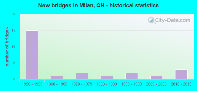
- New bridges - historical statistics
- 151950-1959
- 11960-1969
- 21970-1979
- 11980-1989
- 21990-1999
- 12000-2009
- 32010-2019

- Reconstructed bridges - Historical Statistics
- 21980-1989
- 41990-1999
- 22000-2009


- Bridge Condition - Deck
- 21.4%Excellent
- 7.1%Very good
- 57.1%Good
- 14.3%Satisfactory

- Bridge Condition - Superstructure
- 7.1%Excellent
- 21.4%Very good
- 64.3%Good
- 7.1%Satisfactory

- Bridge Condition - Substructure
- 7.1%Excellent
- 14.3%Very good
- 50.0%Good
- 21.4%Satisfactory
- 7.1%Fair

- Bridge Condition - Channel
- 16.7%Excellent
- 8.3%Very good
- 25.0%Good
- 41.7%Satisfactory
- 8.3%Fair

- Bridge Condition - Culverts
- 20.0%Excellent
- 20.0%Very good
- 40.0%Good
- 20.0%Satisfactory
Find on map >> Show street view
Structure Number: 2202409, Location: 1.85 MILES NORTH OF SR250 (Lat: 41.333839, Lng: -82.588750), Route carried "on" structure: State highway 13, Year Built: 1960, Status: Open, Structure Length: 4.05m (13.29ft), Average Daily Traffic: 4,190 (year 2015), Truck Traffic: 8%, Average Future Daily Traffic: 5,816 (year 2035), Design Load: H 15, Features Intersected: OVER N&S RR
Minimum Vertical Clearance: 30+ m (98+ ft), Kilometerpoint: 5.906, Lanes on structure: 2, Owner: State Highway Agency, Approaching Roadway Width: 13.4m (44.0ft), Skew: 2 degrees, Material/Design: Steel continuous, Design/Construction: Stringer/Multi-beam, Number Of Spans In Main Unit: 3, Length of Maximum Span: 14.3m (46.9ft), Curb or Sidewalk Widths: Left: 0.3m (1.0ft), Right: 0.3m (1.0ft), Curb-To-Curb Width: 11.5m (37.7ft), Out-to-Out Width: 12.9m (42.3ft)
Condition: Deck: Satisfactory, Superstructure: Good, Substructure: Satisfactory, Operating Rating: 45.4 metric tons, Method Used To Determine Operating Rating: Load Factor (LF) rating reported by rating factor (RF) method using MS18 loading, Inventory Rating: 25.9 metric tons, Method Used To Determine Inventory Rating: Load Factor (LF) rating reported by rating factor (RF) method using MS18 loading, Structural Evaluation: Equal to present minimum criteria, Deck Geometry: Somewhat better than minimum adequacy, Underclear: Meets minimum limits, Approach Roadway Alignment: Equal to present desirable criteria, Designated Inspection Frequency: Every 12 months, Inspection Date: March 2021, Deck Structure Type: Concrete Cast-file-Place, Wearing Surface/Protective System: Wearing Surface: Integral Concrete
Find on map >> Show street view
Structure Number: 2202956, Location: .32 MILES EAST OF SR 601 (Lat: 41.299331, Lng: -82.600200), Route carried "on" structure: State highway 113, Year Built: 2006, Status: Open, Structure Length: 0.94m (3.08ft), Average Daily Traffic: 3,616 (year 2015), Truck Traffic: 5%, Average Future Daily Traffic: 5,019 (year 2035), Design Load: HS 20+Mod, Features Intersected: TRIB. OF HURON RIVER
Minimum Vertical Clearance: 30+ m (98+ ft), Kilometerpoint: 11.555, Lanes on structure: 2, Owner: State Highway Agency, Approaching Roadway Width: 8.5m (27.9ft), Material/Design: Steel, Design/Construction: Culvert, Number Of Spans In Main Unit: 2, Length of Maximum Span: 4.1m (13.5ft), Curb or Sidewalk Widths: Left: 0.2m (0.7ft), Right: 0.2m (0.7ft)
Condition: Channel: Fair, Culverts: Good, Operating Rating: 42.1 metric tons, Method Used To Determine Operating Rating: Load and Resistance Factor Rating (LRFR) rating reported by rating factor(RF) method using HL-93 loadings, Inventory Rating: 32.4 metric tons, Method Used To Determine Inventory Rating: Load and Resistance Factor Rating (LRFR) rating reported by rating factor(RF) method using HL-93 loadings, Structural Evaluation: Better than present minimum criteria, Waterway Adequacy: Equal to present desirable criteria, Approach Roadway Alignment: Equal to present desirable criteria, Designated Inspection Frequency: Every 24 months, Inspection Date: March 2021
Find on map >> Show street view
Structure Number: 2203812, Location: 1.08 MI N OF HURON COUNTY (Lat: 41.301389, Lng: -82.609539), Route carried "on" structure: US 250, Year Built: 1956, Year Reconstructed: 2008, Status: Open, Structure Length: 6.09m (19.98ft), Average Daily Traffic: 18,763 (year 2015), Truck Traffic: 8%, Average Future Daily Traffic: 26,043 (year 2035), Design Load: HS 20, Features Intersected: HURON RIVER
Minimum Vertical Clearance: 30+ m (98+ ft), Kilometerpoint: 18.314, Lanes on structure: 4, Base Highway Network: Yes, Owner: State Highway Agency, Approaching Roadway Width: 22.6m (74.1ft), Material/Design: Steel continuous, Design/Construction: Stringer/Multi-beam, Number Of Spans In Main Unit: 3, Length of Maximum Span: 22.9m (75.1ft), Curb-To-Curb Width: 22.6m (74.1ft), Out-to-Out Width: 23.2m (76.1ft)
Condition: Deck: Excellent, Superstructure: Very good, Substructure: Very good, Channel: Good, Operating Rating: 42.1 metric tons, Method Used To Determine Operating Rating: Load Factor (LF) rating reported by rating factor (RF) method using MS18 loading, Inventory Rating: 32.4 metric tons, Method Used To Determine Inventory Rating: Load Factor (LF) rating reported by rating factor (RF) method using MS18 loading, Structural Evaluation: Equal to present desirable criteria, Deck Geometry: Superior to present desirable criteria, Waterway Adequacy: Superior to present desirable criteria, Approach Roadway Alignment: Equal to present desirable criteria, Designated Inspection Frequency: Every 24 months, Inspection Date: March 2021, Deck Structure Type: Concrete Cast-file-Place, Wearing Surface/Protective System: Wearing Surface: Monolithic Concrete, Deck Protection: Epoxy Coated Reinforcing
Find on map >> Show street view
Structure Number: 2229315, Location: 1.3MI WEST OF EXIT 118 (Lat: 41.325819, Lng: -82.631931), Route carried "on" structure: Interstate 80K, Year Built: 1954, Year Reconstructed: 1998, Status: Open, Structure Length: 9.81m (32.19ft), Average Daily Traffic: 40,413 (year 2015), Truck Traffic: 27%, Average Future Daily Traffic: 56,093 (year 2035), Design Load: HS 20+Mod, Features Intersected: N&W RR & KELLY RD, Facility Carried by Structure: I80 OH TPK
Minimum Vertical Clearance: 30+ m (98+ ft), Kilometerpoint: 18.009, Lanes on structure: 6, Lanes under structure: 2, Base Highway Network: Yes, Toll: On toll road, Owner: State Toll Authority, Approaching Roadway Width: 36.6m (120.1ft), Skew: 30 degrees, Material/Design: Steel continuous, Design/Construction: Stringer/Multi-beam, Number Of Spans In Main Unit: 4, Length of Maximum Span: 34.4m (112.9ft), Curb-To-Curb Width: 37.4m (122.7ft), Out-to-Out Width: 38.3m (125.7ft)
Condition: Deck: Good, Superstructure: Good, Substructure: Good, Operating Rating: 71.3 metric tons, Method Used To Determine Operating Rating: Load Factor (LF) rating reported by rating factor (RF) method using MS18 loading, Inventory Rating: 42.1 metric tons, Method Used To Determine Inventory Rating: Load Factor (LF) rating reported by rating factor (RF) method using MS18 loading, Structural Evaluation: Better than present minimum criteria, Deck Geometry: Superior to present desirable criteria, Underclear: Superior to present desirable criteria, Approach Roadway Alignment: Equal to present desirable criteria, Designated Inspection Frequency: Every 12 months, Critical Feature Inspection Frequency: Every 24 months, Inspection Date: March 2021, Critical Feature Inspection Date: September 2020, Deck Structure Type: Concrete Cast-file-Place, Wearing Surface/Protective System: Wearing Surface: Monolithic Concrete, Deck Protection: Epoxy Coated Reinforcing
Find on map >> Show street view
Structure Number: 2229358, Location: 1.2MI WEST OF EXIT 7 (Lat: 41.325319, Lng: -82.629839), Route carried "on" structure: Interstate 80K, Year Built: 1954, Status: Posted for load, Structure Length: 0.85m (2.79ft), Average Daily Traffic: 40,413 (year 2015), Truck Traffic: 27%, Average Future Daily Traffic: 56,093 (year 2035), Design Load: HS 20+Mod, Features Intersected: DITCH, Facility Carried by Structure: I80 OH TPK
Minimum Vertical Clearance: 30+ m (98+ ft), Kilometerpoint: 18.169, Lanes on structure: 6, Base Highway Network: Yes, Toll: On toll road, Owner: State Toll Authority, Approaching Roadway Width: 37.8m (124.0ft), Skew: 5 degrees, Material/Design: Concrete, Design/Construction: Culvert, Number Of Spans In Main Unit: 2, Length of Maximum Span: 3.7m (12.1ft)
Condition: Channel: Satisfactory, Culverts: Satisfactory, Operating Rating: 97.2 metric tons, Method Used To Determine Operating Rating: Load Factor (LF) rating reported by rating factor (RF) method using MS18 loading, Inventory Rating: 74.5 metric tons, Method Used To Determine Inventory Rating: Load Factor (LF) rating reported by rating factor (RF) method using MS18 loading, Structural Evaluation: Equal to present minimum criteria, Waterway Adequacy: Meets minimum limits, Approach Roadway Alignment: Equal to present minimum criteria, Designated Inspection Frequency: Every 12 months, Inspection Date: March 2021
Find on map >> Show street view
Structure Number: 2229382, Location: 0.5MI WEST OF EXIT 7 (Lat: 41.324419, Lng: -82.617389), Route carried "on" structure: Ramp Interstate 80K, Year Built: 1954, Year Reconstructed: 1987, Status: Open, Structure Length: 4.21m (13.81ft), Average Daily Traffic: 2,343 (year 2019), Truck Traffic: 16%, Average Future Daily Traffic: 1,988 (year 2039), Design Load: H 20, Features Intersected: USR 250, Facility Carried by Structure: TPK EXIT 119 RAMP
Minimum Vertical Clearance: 30+ m (98+ ft), Kilometerpoint: 1.616, Lanes on structure: 2, Lanes under structure: 4, Owner: State Toll Authority, Approaching Roadway Width: 14.6m (47.9ft), Skew: 20 degrees, Material/Design: Steel, Design/Construction: Girder and Floorbeam System, Number Of Spans In Main Unit: 1, Number Of Approach Spans: 2, Length of Maximum Span: 25.3m (83.0ft), Curb-To-Curb Width: 9.1m (29.9ft), Out-to-Out Width: 10.1m (33.1ft)
Condition: Deck: Good, Superstructure: Satisfactory, Substructure: Fair, Operating Rating: 48.6 metric tons, Method Used To Determine Operating Rating: Load Factor (LF) rating reported by rating factor (RF) method using MS18 loading, Inventory Rating: 29.2 metric tons, Method Used To Determine Inventory Rating: Load Factor (LF) rating reported by rating factor (RF) method using MS18 loading, Structural Evaluation: Somewhat better than minimum adequacy, Deck Geometry: Meets minimum limits, Underclear: High priority of corrective action, Approach Roadway Alignment: Equal to present desirable criteria, Designated Inspection Frequency: Every 12 months, Critical Feature Inspection Frequency: Every 24 months, Inspection Date: July 2021, Critical Feature Inspection Date: July 2021, Deck Structure Type: Concrete Cast-file-Place, Wearing Surface/Protective System: Wearing Surface: Monolithic Concrete, Deck Protection: Epoxy Coated Reinforcing
Find on map >> Show street view
Structure Number: 222939, Location: 0.5MI WEST OF EXIT 118 (Lat: 41.322989, Lng: -82.616819), Route carried "on" structure: Interstate 80K, Year Built: 1954, Year Reconstructed: 1998, Status: Open, Structure Length: 6.34m (20.80ft), Average Daily Traffic: 40,413 (year 2015), Truck Traffic: 27%, Average Future Daily Traffic: 56,093 (year 2035), Design Load: HS 20+Mod, Features Intersected: USR 250, Facility Carried by Structure: I80 OH TPK
Minimum Vertical Clearance: 30+ m (98+ ft), Kilometerpoint: 19.344, Lanes on structure: 6, Lanes under structure: 4, Base Highway Network: Yes, Toll: On toll road, Owner: State Toll Authority, Approaching Roadway Width: 36.6m (120.1ft), Skew: 33 degrees, Material/Design: Steel, Design/Construction: Stringer/Multi-beam, Number Of Spans In Main Unit: 3, Length of Maximum Span: 28.7m (94.2ft), Curb-To-Curb Width: 37.4m (122.7ft), Out-to-Out Width: 38.3m (125.7ft)
Condition: Deck: Good, Superstructure: Good, Substructure: Satisfactory, Operating Rating: 42.1 metric tons, Method Used To Determine Operating Rating: Load Factor (LF) rating reported by rating factor (RF) method using MS18 loading, Inventory Rating: 25.9 metric tons, Method Used To Determine Inventory Rating: Load Factor (LF) rating reported by rating factor (RF) method using MS18 loading, Structural Evaluation: Equal to present minimum criteria, Deck Geometry: Superior to present desirable criteria, Underclear: Meets minimum limits, Approach Roadway Alignment: Equal to present desirable criteria, Designated Inspection Frequency: Every 12 months, Inspection Date: March 2021, Deck Structure Type: Concrete Cast-file-Place, Wearing Surface/Protective System: Wearing Surface: Monolithic Concrete, Deck Protection: Epoxy Coated Reinforcing
Find on map >> Show street view
Structure Number: 2229439, Location: TURNPIKE MILEPOST 118.6 (Lat: 41.322811, Lng: -82.608169), Route carried "on" structure: Ramp Interstate 80K, Year Built: 1997, Status: Open, Structure Length: 7.77m (25.49ft), Average Daily Traffic: 1,432 (year 2017), Truck Traffic: 92%, Average Future Daily Traffic: 1,988 (year 2037), Design Load: HS 25 or greater, Features Intersected: I80 OHIO TURNPIKE, Facility Carried by Structure: TPK EXIT 118 RAMP
Minimum Vertical Clearance: 30+ m (98+ ft), Kilometerpoint: 1.328, Lanes on structure: 2, Lanes under structure: 7, Toll: On toll road, Owner: State Toll Authority, Approaching Roadway Width: 18.9m (62.0ft), Skew: 20 degrees, Material/Design: Steel continuous, Design/Construction: Stringer/Multi-beam, Number Of Spans In Main Unit: 4, Length of Maximum Span: 26.8m (87.9ft), Curb-To-Curb Width: 18.9m (62.0ft), Out-to-Out Width: 19.8m (65.0ft)
Condition: Deck: Good, Superstructure: Good, Substructure: Good, Operating Rating: 68.0 metric tons, Method Used To Determine Operating Rating: Load Factor (LF) rating reported by rating factor (RF) method using MS18 loading, Inventory Rating: 38.9 metric tons, Method Used To Determine Inventory Rating: Load Factor (LF) rating reported by rating factor (RF) method using MS18 loading, Structural Evaluation: Better than present minimum criteria, Deck Geometry: Superior to present desirable criteria, Underclear: Meets minimum limits, Approach Roadway Alignment: Equal to present minimum criteria, Designated Inspection Frequency: Every 24 months, Inspection Date: March 2021, Deck Structure Type: Concrete Cast-file-Place, Wearing Surface/Protective System: Wearing Surface: Monolithic Concrete, Deck Protection: Epoxy Coated Reinforcing
Find on map >> Show street view
Structure Number: 2229447, Location: 0.7MI EAST OF EXIT 7 (Lat: 41.323961, Lng: -82.594631), Route carried "on" structure: State highway 13, Year Built: 1954, Year Reconstructed: 1989, Status: Open, Structure Length: 8.05m (26.41ft), Average Daily Traffic: 4,464 (year 2017), Truck Traffic: 20%, Average Future Daily Traffic: 6,196 (year 2037), Design Load: H 10, Features Intersected: I80 OHIO TURNPIKE
Minimum Vertical Clearance: 30+ m (98+ ft), Kilometerpoint: 4.715, Lanes on structure: 2, Lanes under structure: 6, Owner: State Toll Authority, Approaching Roadway Width: 10.1m (33.1ft), Skew: 1 degrees, Material/Design: Steel continuous, Design/Construction: Stringer/Multi-beam, Number Of Spans In Main Unit: 4, Length of Maximum Span: 21.9m (71.9ft), Curb-To-Curb Width: 9.4m (30.8ft), Out-to-Out Width: 10.3m (33.8ft)
Condition: Deck: Satisfactory, Superstructure: Good, Substructure: Good, Operating Rating: 58.3 metric tons, Method Used To Determine Operating Rating: Load Factor (LF) rating reported by rating factor (RF) method using MS18 loading, Inventory Rating: 35.6 metric tons, Method Used To Determine Inventory Rating: Load Factor (LF) rating reported by rating factor (RF) method using MS18 loading, Structural Evaluation: Better than present minimum criteria, Deck Geometry: Meets minimum limits, Underclear: High priority of corrective action, Approach Roadway Alignment: Equal to present desirable criteria, Designated Inspection Frequency: Every 12 months, Inspection Date: March 2021, Deck Structure Type: Concrete Cast-file-Place, Wearing Surface/Protective System: Wearing Surface: Monolithic Concrete, Deck Protection: Epoxy Coated Reinforcing
Find on map >> Show street view
Structure Number: 2229463, Location: 1MI EAST OF EXIT 7 (Lat: 41.323961, Lng: -82.591039), Route carried "on" structure: Interstate 80K, Year Built: 1954, Year Reconstructed: 1998, Status: Open, Structure Length: 33.85m (111.06ft), Average Daily Traffic: 20,287 (year 2015), Truck Traffic: 27%, Average Future Daily Traffic: 28,158 (year 2035), Design Load: HS 20+Mod, Features Intersected: HURON RIVER &RR (CLOSED), Facility Carried by Structure: I80 OH TPK
Minimum Vertical Clearance: 30+ m (98+ ft), Kilometerpoint: 21.501, Lanes on structure: 6, Base Highway Network: Yes, Toll: On toll road, Owner: State Toll Authority, Approaching Roadway Width: 36.6m (120.1ft), Skew: 30 degrees, Navigation Control: Yes ( Vertical Clearance: 9.1m (29.9ft), Horizontal Clearance: 24.4m (80.1ft)), Material/Design: Steel, Design/Construction: Stringer/Multi-beam, Number Of Spans In Main Unit: 9, Length of Maximum Span: 39.3m (128.9ft), Curb-To-Curb Width: 36.8m (120.7ft), Out-to-Out Width: 38.7m (127.0ft)
Condition: Deck: Good, Superstructure: Good, Substructure: Good, Channel: Satisfactory, Operating Rating: 55.1 metric tons, Method Used To Determine Operating Rating: Load Factor (LF) rating reported by rating factor (RF) method using MS18 loading, Inventory Rating: 32.4 metric tons, Method Used To Determine Inventory Rating: Load Factor (LF) rating reported by rating factor (RF) method using MS18 loading, Structural Evaluation: Better than present minimum criteria, Deck Geometry: Superior to present desirable criteria, Waterway Adequacy: Superior to present desirable criteria, Approach Roadway Alignment: Equal to present desirable criteria, Designated Inspection Frequency: Every 24 months, Inspection Date: July 2021, Deck Structure Type: Concrete Cast-file-Place, Wearing Surface/Protective System: Wearing Surface: Monolithic Concrete, Deck Protection: Epoxy Coated Reinforcing
Find on map >> Show street view
Structure Number: 2229501, Location: 1.5MI EAST OF EXIT 7 (Lat: 41.322889, Lng: -82.580089), Route carried "on" structure: County highway 126, Year Built: 1954, Status: Open, Structure Length: 6.22m (20.41ft), Average Daily Traffic: 662 (year 2017), Truck Traffic: 7%, Average Future Daily Traffic: 919 (year 2037), Design Load: H 10, Features Intersected: I80 OHIO TURNPIKE
Minimum Vertical Clearance: 30+ m (98+ ft), Kilometerpoint: 2.849, Lanes on structure: 2, Lanes under structure: 6, Owner: State Toll Authority, Approaching Roadway Width: 8.2m (26.9ft), Skew: 1 degrees, Material/Design: Steel continuous, Design/Construction: Stringer/Multi-beam, Number Of Spans In Main Unit: 2, Number Of Approach Spans: 2, Length of Maximum Span: 21.0m (68.9ft), Curb-To-Curb Width: 8.1m (26.6ft), Out-to-Out Width: 9.1m (29.9ft)
Condition: Deck: Excellent, Superstructure: Very good, Substructure: Very good, Operating Rating: 55.7 metric tons, Method Used To Determine Operating Rating: Load Factor (LF) rating reported by rating factor (RF) method using MS18 loading, Inventory Rating: 33.4 metric tons, Method Used To Determine Inventory Rating: Load Factor (LF) rating reported by rating factor (RF) method using MS18 loading, Structural Evaluation: Equal to present desirable criteria, Deck Geometry: Somewhat better than minimum adequacy, Underclear: High priority of corrective action, Approach Roadway Alignment: Equal to present desirable criteria, Designated Inspection Frequency: Every 24 months, Inspection Date: July 2021, Deck Structure Type: Concrete Cast-file-Place, Wearing Surface/Protective System: Wearing Surface: Latex Concrete
Find on map >> Show street view
Structure Number: 2230186, Location: MI-212 (Lat: 41.336511, Lng: -82.579000), Route carried "on" structure: County highway C0013, Year Built: 1973, Status: Open, Structure Length: 8.56m (28.08ft), Average Daily Traffic: 1,061 (year 2015), Truck Traffic: 8%, Average Future Daily Traffic: 1,473 (year 2035), Design Load: HS 20, Features Intersected: MASON RD/HURON RIVER, Facility Carried by Structure: MASON RD CR13
Minimum Vertical Clearance: 30+ m (98+ ft), Kilometerpoint: 21.613, Lanes on structure: 2, Owner: County Highway Agency, Approaching Roadway Width: 9.8m (32.2ft), Skew: 3 degrees, Navigation Control: Yes ( Vertical Clearance: 5.2m (17.1ft), Horizontal Clearance: 24.7m (81.0ft)), Material/Design: Steel continuous, Design/Construction: Stringer/Multi-beam, Number Of Spans In Main Unit: 3, Length of Maximum Span: 35.1m (115.2ft), Curb-To-Curb Width: 12.2m (40.0ft), Out-to-Out Width: 12.2m (40.0ft)
Condition: Deck: Good, Superstructure: Good, Substructure: Good, Channel: Very good, Operating Rating: 29.2 metric tons, Method Used To Determine Operating Rating: Load and Resistance Factor Rating (LRFR) rating reported by rating factor(RF) method using HL-93 loadings, Inventory Rating: 22.7 metric tons, Method Used To Determine Inventory Rating: Load and Resistance Factor Rating (LRFR) rating reported by rating factor(RF) method using HL-93 loadings, Structural Evaluation: Equal to present minimum criteria, Deck Geometry: Better than present minimum criteria, Waterway Adequacy: Equal to present desirable criteria, Approach Roadway Alignment: Equal to present desirable criteria, Designated Inspection Frequency: Every 24 months, Underwater Inspection Frequency: Every 60 months, Inspection Date: December 2021, Underwater Inspection Date: July 2021, Deck Structure Type: Concrete Cast-file-Place, Wearing Surface/Protective System: Wearing Surface: Bituminous, Membrane: Preformed Fabric
Find on map >> Show street view
Structure Number: 2230437, Location: MI-324 (Lat: 41.325239, Lng: -82.631619), Route carried "on" structure: County highway T0116, Year Built: 1954, Year Reconstructed: 1998, Status: Posted for load, Structure Length: 0.94m (3.08ft), Average Daily Traffic: 791 (year 2015), Truck Traffic: 8%, Average Future Daily Traffic: 1,098 (year 2035), Design Load: H 15, Features Intersected: KELLEY RD/MUD BROOK, Facility Carried by Structure: KELLEY RD TR116
Minimum Vertical Clearance: 30+ m (98+ ft), Kilometerpoint: 3.492, Lanes on structure: 2, Owner: County Highway Agency, Approaching Roadway Width: 8.2m (26.9ft), Skew: 3 degrees, Material/Design: Concrete, Design/Construction: Slab, Number Of Spans In Main Unit: 2, Length of Maximum Span: 4.3m (14.1ft), Curb-To-Curb Width: 9.8m (32.2ft), Out-to-Out Width: 9.8m (32.2ft)
Condition: Deck: Good, Superstructure: Good, Substructure: Good, Channel: Good, Operating Rating: 19.4 metric tons, Method Used To Determine Operating Rating: Load Factor (LF) rating reported by rating factor (RF) method using MS18 loading, Inventory Rating: 13.0 metric tons, Method Used To Determine Inventory Rating: Load Factor (LF) rating reported by rating factor (RF) method using MS18 loading, Structural Evaluation: Meets minimum limits, Deck Geometry: Equal to present minimum criteria, Waterway Adequacy: Superior to present desirable criteria, Approach Roadway Alignment: Equal to present minimum criteria, Bridge Posting: Required (Relationship of Operating Rating to Maximum Legal Load: > 39.9% below), Designated Inspection Frequency: Every 12 months, Inspection Date: December 2021, Deck Structure Type: Concrete Cast-file-Place, Wearing Surface/Protective System: Wearing Surface: Bituminous
Find on map >> Show street view
Structure Number: 2231018, Location: MI-103 (Lat: 41.289011, Lng: -82.571731), Route carried "on" structure: County highway T0054, Year Built: 1970, Status: Posted for load, Structure Length: 0.67m (2.20ft), Average Daily Traffic: 291 (year 2015), Truck Traffic: 5%, Average Future Daily Traffic: 404 (year 2035), Design Load: H 20, Features Intersected: MCINTYRE RD-HURON RIVER, Facility Carried by Structure: MCINTYRE RD TR54
Minimum Vertical Clearance: 30+ m (98+ ft), Kilometerpoint: 0.241, Lanes on structure: 1, Owner: County Highway Agency, Approaching Roadway Width: 4.9m (16.1ft), Skew: 1 degrees, Material/Design: Steel, Design/Construction: Culvert, Number Of Spans In Main Unit: 1, Length of Maximum Span: 6.4m (21.0ft)
Condition: Channel: Satisfactory, Culverts: Good, Operating Rating: 25.9 metric tons, Method Used To Determine Operating Rating: Load and Resistance Factor Rating (LRFR) rating reported by rating factor(RF) method using HL-93 loadings, Inventory Rating: 19.4 metric tons, Method Used To Determine Inventory Rating: Load and Resistance Factor Rating (LRFR) rating reported by rating factor(RF) method using HL-93 loadings, Structural Evaluation: Somewhat better than minimum adequacy, Waterway Adequacy: Better than present minimum criteria, Approach Roadway Alignment: Equal to present minimum criteria, Bridge Posting: Required (Relationship of Operating Rating to Maximum Legal Load: 20.0 - 29.9% below), Designated Inspection Frequency: Every 12 months, Inspection Date: December 2021
Find on map >> Show street view
Structure Number: 2231476, Location: MI-404 (Lat: 41.296389, Lng: -82.594739), Route carried "on" structure: County highway T1104, Year Built: 1986, Status: Open, Structure Length: 1.19m (3.90ft), Average Daily Traffic: 1,295 (year 2015), Truck Traffic: 5%, Average Future Daily Traffic: 1,797 (year 2035), Design Load: HS 20, Features Intersected: BERLIN ST-HURON RIVER, Facility Carried by Structure: BERLIN ST TR1104
Minimum Vertical Clearance: 30+ m (98+ ft), Kilometerpoint: 0.354, Lanes on structure: 2, Owner: County Highway Agency, Approaching Roadway Width: 6.7m (22.0ft), Material/Design: Prestressed concrete, Design/Construction: Box Beam or Girders - Multiple, Number Of Spans In Main Unit: 1, Length of Maximum Span: 11.6m (38.1ft), Curb-To-Curb Width: 8.5m (27.9ft), Out-to-Out Width: 8.5m (27.9ft)
Condition: Deck: Good, Superstructure: Good, Substructure: Good, Channel: Satisfactory, Operating Rating: 38.9 metric tons, Method Used To Determine Operating Rating: Load and Resistance Factor Rating (LRFR) rating reported by rating factor(RF) method using HL-93 loadings, Inventory Rating: 29.2 metric tons, Method Used To Determine Inventory Rating: Load and Resistance Factor Rating (LRFR) rating reported by rating factor(RF) method using HL-93 loadings, Structural Evaluation: Better than present minimum criteria, Deck Geometry: Somewhat better than minimum adequacy, Waterway Adequacy: Better than present minimum criteria, Approach Roadway Alignment: Equal to present minimum criteria, Designated Inspection Frequency: Every 24 months, Inspection Date: December 2021, Deck Structure Type: Concrete Cast-file-Place, Wearing Surface/Protective System: Wearing Surface: Bituminous, Membrane: Built-up
Find on map >> Show street view
Structure Number: 2232111, Location: MI-407 (Lat: 41.294489, Lng: -82.612200), Route carried "on" structure: County highway T0049, Year Built: 2010, Status: Open, Structure Length: 0.88m (2.89ft), Average Daily Traffic: 1,166 (year 2015), Truck Traffic: 5%, Average Future Daily Traffic: 1,618 (year 2035), Design Load: HL 93, Features Intersected: SHAWMILL RD/RATTLESNK CR, Facility Carried by Structure: SHAW MILL RD TR49
Minimum Vertical Clearance: 30+ m (98+ ft), Kilometerpoint: 1.352, Lanes on structure: 2, Owner: County Highway Agency, Approaching Roadway Width: 7.6m (24.9ft), Skew: 1 degrees, Material/Design: Concrete, Design/Construction: Culvert, Number Of Spans In Main Unit: 1, Length of Maximum Span: 8.2m (26.9ft)
Condition: Channel: Satisfactory, Culverts: Very good, Operating Rating: 94.0 metric tons, Method Used To Determine Operating Rating: Load Factor (LF) rating reported by rating factor (RF) method using MS18 loading, Inventory Rating: 58.3 metric tons, Method Used To Determine Inventory Rating: Load Factor (LF) rating reported by rating factor (RF) method using MS18 loading, Structural Evaluation: Equal to present desirable criteria, Waterway Adequacy: Equal to present minimum criteria, Approach Roadway Alignment: Better than present minimum criteria, Designated Inspection Frequency: Every 24 months, Inspection Date: December 2021
Find on map >> Show street view
Structure Number: 390211, Location: 3.08 MILES N. OF USR250 (Lat: 41.269869, Lng: -82.571711), Route carried "on" structure: State highway 61, Year Built: 2013, Status: Open, Structure Length: 0.77m (2.53ft), Average Daily Traffic: 3,563 (year 2015), Truck Traffic: 5%, Average Future Daily Traffic: 4,945 (year 2035), Design Load: HL 93, Features Intersected: RATTLESNAKE CREEK
Minimum Vertical Clearance: 30+ m (98+ ft), Kilometerpoint: 35.196, Lanes on structure: 2, Owner: State Highway Agency, Approaching Roadway Width: 9.8m (32.2ft), Skew: 2 degrees, Material/Design: Steel, Design/Construction: Culvert, Number Of Spans In Main Unit: 1, Length of Maximum Span: 7.3m (24.0ft), Curb or Sidewalk Widths: Left: 0.1m (0.3ft), Right: 0.1m (0.3ft)
Condition: Channel: Excellent, Culverts: Excellent, Operating Rating: 42.1 metric tons, Method Used To Determine Operating Rating: Load and Resistance Factor Rating (LRFR) rating reported by rating factor(RF) method using HL-93 loadings, Inventory Rating: 32.4 metric tons, Method Used To Determine Inventory Rating: Load and Resistance Factor Rating (LRFR) rating reported by rating factor(RF) method using HL-93 loadings, Structural Evaluation: Equal to present desirable criteria, Waterway Adequacy: Equal to present desirable criteria, Approach Roadway Alignment: Equal to present desirable criteria, Designated Inspection Frequency: Every 24 months, Inspection Date: March 2021
Find on map >> Show street view
Structure Number: 3903494, Location: .04 MI.S.OF ERIE CO.LINE (Lat: 41.285881, Lng: -82.605761), Route carried "on" structure: US 250, Year Built: 2011, Status: Open, Structure Length: 7.28m (23.88ft), Average Daily Traffic: 14,942 (year 2015), Truck Traffic: 5%, Average Future Daily Traffic: 20,739 (year 2035), Design Load: HS 20, Features Intersected: RATTLESNAKE CREEK
Minimum Vertical Clearance: 30+ m (98+ ft), Kilometerpoint: 0.064, Lanes on structure: 2, Base Highway Network: Yes, Owner: State Highway Agency, Approaching Roadway Width: 14.3m (46.9ft), Material/Design: Prestressed concrete continuous, Design/Construction: Stringer/Multi-beam, Number Of Spans In Main Unit: 3, Length of Maximum Span: 27.7m (90.9ft), Curb-To-Curb Width: 13.4m (44.0ft), Out-to-Out Width: 14.3m (46.9ft)
Condition: Deck: Excellent, Superstructure: Excellent, Substructure: Excellent, Channel: Excellent, Operating Rating: 55.1 metric tons, Method Used To Determine Operating Rating: Load Factor (LF) rating reported by rating factor (RF) method using MS18 loading, Inventory Rating: 35.6 metric tons, Method Used To Determine Inventory Rating: Load Factor (LF) rating reported by rating factor (RF) method using MS18 loading, Structural Evaluation: Superior to present desirable criteria, Deck Geometry: Equal to present minimum criteria, Waterway Adequacy: Superior to present desirable criteria, Approach Roadway Alignment: Equal to present desirable criteria, Designated Inspection Frequency: Every 24 months, Inspection Date: March 2021, Deck Structure Type: Concrete Cast-file-Place, Wearing Surface/Protective System: Wearing Surface: Monolithic Concrete, Deck Protection: Epoxy Coated Reinforcing
Find on map >> Show street view
Structure Number: 3932478, Location: 0.1 MI N OF MILAN MANOR (Lat: 41.276919, Lng: -82.591900), Route carried "on" structure: County highway C0052, Year Built: 1952, Year Reconstructed: 2000, Status: Open, Structure Length: 1.59m (5.22ft), Average Daily Traffic: 1,547 (year 2015), Truck Traffic: 5%, Average Future Daily Traffic: 2,147 (year 2035), Design Load: HS 20, Features Intersected: OLD STATE/RATTLE SNAK CR, Facility Carried by Structure: OLD STATE 52
Minimum Vertical Clearance: 30+ m (98+ ft), Kilometerpoint: 7.194, Lanes on structure: 2, Owner: County Highway Agency, Approaching Roadway Width: 9.1m (29.9ft), Material/Design: Prestressed concrete, Design/Construction: Box Beam or Girders - Multiple, Number Of Spans In Main Unit: 1, Length of Maximum Span: 15.5m (50.9ft), Curb-To-Curb Width: 8.6m (28.2ft), Out-to-Out Width: 9.5m (31.2ft)
Condition: Deck: Very good, Superstructure: Very good, Substructure: Satisfactory, Channel: Good, Operating Rating: 42.1 metric tons, Method Used To Determine Operating Rating: Load Factor (LF) rating reported by rating factor (RF) method using MS18 loading, Inventory Rating: 32.4 metric tons, Method Used To Determine Inventory Rating: Load Factor (LF) rating reported by rating factor (RF) method using MS18 loading, Structural Evaluation: Equal to present minimum criteria, Deck Geometry: Somewhat better than minimum adequacy, Waterway Adequacy: Superior to present desirable criteria, Approach Roadway Alignment: Superior to present desirable criteria, Designated Inspection Frequency: Every 12 months, Inspection Date: May 2021, Deck Structure Type: Concrete Cast-file-Place, Wearing Surface/Protective System: Wearing Surface: Bituminous, Membrane: Preformed Fabric
Find on map >> Show street view
Structure Number: 2229315, Location: 1.3MI WEST OF EXIT 118 (Lat: 41.325819, Lng: -82.631931), Route carried "under" structure: County highway 116, Year Built: 1954, Structure Length: 0. m, Average Daily Traffic: 791 (year 2015), Truck Traffic: 8%, Features Intersected: I80 OHIO TPK, Facility Carried by Structure: KELLY RD
Minimum Vertical Clearance: 6.78m (22.24ft), Kilometerpoint: 18.073, Lanes on structure: 6, Lanes under structure: 2, Material/Design: Steel continuous, Design/Construction: Stringer/Multi-beam, Length of Maximum Span: 34.4m (112.9ft)
Find on map >> Show street view
Structure Number: 2229382, Location: 0.5MI WEST OF EXIT 7 (Lat: 41.324419, Lng: -82.617389), Route carried "under" structure: US 250, Year Built: 1954, Structure Length: 0. m, Average Daily Traffic: 16,840 (year 2019), Truck Traffic: 12%, Features Intersected: I80 OH TPK RMP
Minimum Vertical Clearance: 4.52m (14.83ft), Kilometerpoint: 15.401, Lanes on structure: 2, Lanes under structure: 4, Material/Design: Steel, Design/Construction: Girder and Floorbeam System, Length of Maximum Span: 25.3m (83.0ft)
Find on map >> Show street view
Structure Number: 222939, Location: 0.5MI WEST OF EXIT 118 (Lat: 41.322989, Lng: -82.616819), Route carried "under" structure: US 250, Year Built: 1954, Structure Length: 0. m, Average Daily Traffic: 16,236 (year 2015), Truck Traffic: 4%, Features Intersected: I80 OHIO TPK
Minimum Vertical Clearance: 4.93m (16.17ft), Kilometerpoint: 17.349, Lanes on structure: 6, Lanes under structure: 4, Material/Design: Steel, Design/Construction: Stringer/Multi-beam, Length of Maximum Span: 28.7m (94.2ft)
Find on map >> Show street view
Structure Number: 2229439, Location: TURNPIKE MILEPOST 118.6 (Lat: 41.322811, Lng: -82.608169), Route carried "under" structure: Interstate 80K, Year Built: 1997, Structure Length: 0. m, Average Daily Traffic: 40,322 (year 2017), Truck Traffic: 35%, Features Intersected: EXIT 118 RAMP, Facility Carried by Structure: I80 OHIO TURNPIKE
Minimum Vertical Clearance: 4.60m (15.09ft), Kilometerpoint: 20.064, Lanes on structure: 2, Lanes under structure: 7, Toll: On toll road, Material/Design: Steel continuous, Design/Construction: Stringer/Multi-beam, Length of Maximum Span: 26.8m (87.9ft)
Find on map >> Show street view
Structure Number: 2229447, Location: 0.7MI EAST OF EXIT 7 (Lat: 41.323961, Lng: -82.594631), Route carried "under" structure: Interstate 80K, Year Built: 1954, Structure Length: 0. m, Average Daily Traffic: 40,322 (year 2017), Truck Traffic: 35%, Features Intersected: SR-13, Facility Carried by Structure: I80 OHIO TURNPIKE
Minimum Vertical Clearance: 5.51m (18.08ft), Kilometerpoint: 21.227, Lanes on structure: 2, Lanes under structure: 6, Toll: On toll road, Material/Design: Steel continuous, Design/Construction: Stringer/Multi-beam, Length of Maximum Span: 21.9m (71.9ft)
Find on map >> Show street view
Structure Number: 2229501, Location: 1.5MI EAST OF EXIT 7 (Lat: 41.322889, Lng: -82.580089), Route carried "under" structure: Interstate 80K, Year Built: 1954, Structure Length: 0. m, Average Daily Traffic: 40,322 (year 2017), Truck Traffic: 35%, Features Intersected: RIVER RD TR-126, Facility Carried by Structure: I80 OHIO TURNPIKE
Minimum Vertical Clearance: 4.47m (14.67ft), Kilometerpoint: 22.442, Lanes on structure: 2, Lanes under structure: 6, Toll: On toll road, Material/Design: Steel continuous, Design/Construction: Stringer/Multi-beam, Length of Maximum Span: 21.0m (68.9ft)