Bridge Statistics for Milford, Pennsylvania (PA)
Condition, Traffic, Stress, Structural Evaluation, Project Costs
- National Bridge Inventory (NBI) Statistics
- 20Number of bridges
- 443ft / 135mTotal length
- $19,487,000Total costs
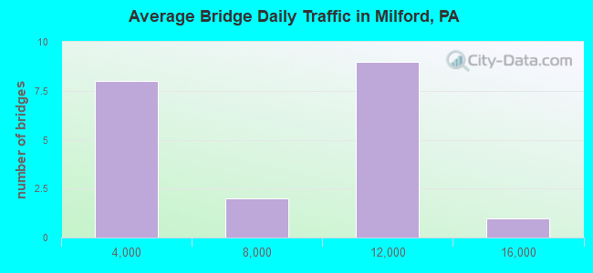
- 116,958Total average daily traffic
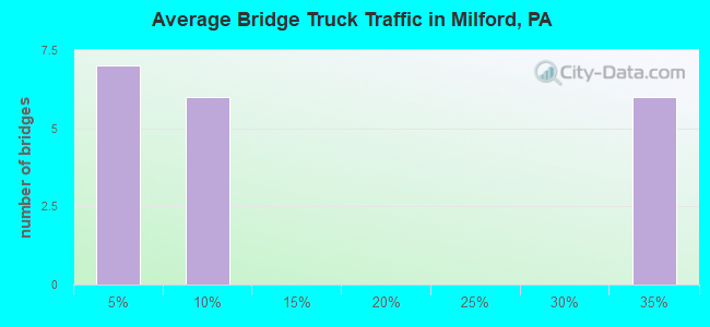
- 20,379Total average daily truck traffic
- National Bridge Inventory (NBI) Registered Bridges for Milford
- No street view available for this location
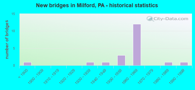
- New bridges - historical statistics
- 1Before 1900
- 11930-1939
- 11940-1949
- 31950-1959
- 121960-1969
- 11980-1989
- 11990-1999
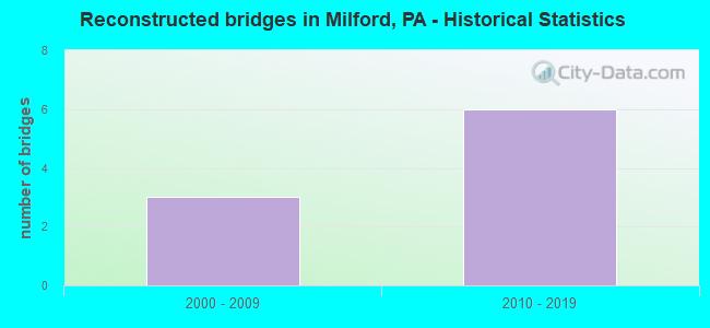
- Reconstructed bridges - Historical Statistics
- 32000-2009
- 62010-2019
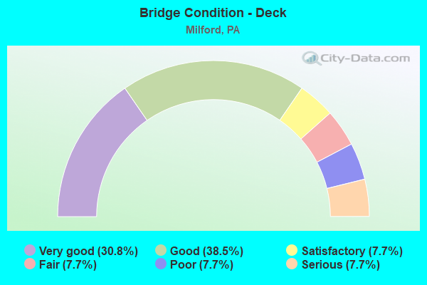
- Bridge Condition - Deck
- 30.8%Very good
- 38.5%Good
- 7.7%Satisfactory
- 7.7%Fair
- 7.7%Poor
- 7.7%Serious
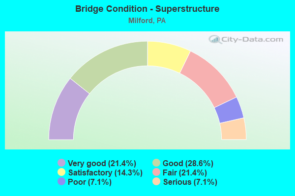
- Bridge Condition - Superstructure
- 21.4%Very good
- 28.6%Good
- 14.3%Satisfactory
- 21.4%Fair
- 7.1%Poor
- 7.1%Serious
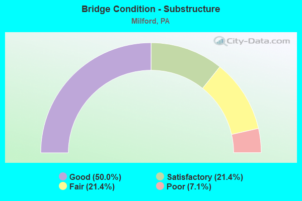
- Bridge Condition - Substructure
- 50.0%Good
- 21.4%Satisfactory
- 21.4%Fair
- 7.1%Poor
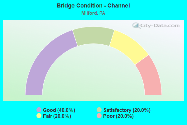
- Bridge Condition - Channel
- 40.0%Good
- 20.0%Satisfactory
- 20.0%Fair
- 20.0%Poor
Find on map >> Show street view
Structure Number: 3007, Location: 1/112TH INFANTRY ALPHA CO (Lat: 40.793456, Lng: -79.514806), Route carried "on" structure: State highway 66, Year Built: 1980, Year Reconstructed: 2010, Status: Open, Structure Length: 40.72m (133.60ft), Average Daily Traffic: 14,054 (year 2022), Truck Traffic: 5%, Average Future Daily Traffic: 21,410 (year 2032), Design Load: HS 20, Features Intersected: SR0422;SR2025;GARRETTS
Minimum Vertical Clearance: 30+ m (98+ ft), Kilometerpoint: 32.605, Lanes on structure: 2, Lanes under structure: 9, Owner: State Highway Agency, Approaching Roadway Width: 26.8m (87.9ft), Skew: 30 degrees, Material/Design: Steel continuous, Design/Construction: Stringer/Multi-beam, Number Of Spans In Main Unit: 8, Number Of Approach Spans: 1, Length of Maximum Span: 58.2m (190.9ft), Curb or Sidewalk Widths: Left: 0.2m (0.7ft), Right: 0.2m (0.7ft), Curb-To-Curb Width: 26.3m (86.3ft), Out-to-Out Width: 28.7m (94.2ft)
Condition: Deck: Satisfactory, Superstructure: Fair, Substructure: Satisfactory, Channel: Fair, Operating Rating: 79.8 metric tons, Method Used To Determine Operating Rating: Load Factor (LF), Inventory Rating: 42.6 metric tons, Method Used To Determine Inventory Rating: Load Factor (LF), Structural Evaluation: Somewhat better than minimum adequacy, Deck Geometry: Superior to present desirable criteria, Underclear: High priority of corrective action, Waterway Adequacy: Superior to present desirable criteria, Approach Roadway Alignment: Equal to present desirable criteria, Length Of Structure Improvement: 41.30m (135.50ft), Designated Inspection Frequency: Every 24 months, Other Special Inspection Frequency: Every 6 months, Inspection Date: April 2020, Other Special Inspection Date: October 2021, Bridge Improvement Cost: $900,000, Roadway Improvement Cost: $2,651,000, Total Project Cost: $12,151,000, Deck Structure Type: Concrete Cast-file-Place, Wearing Surface/Protective System: Wearing Surface: Epoxy Overlay, Membrane: Epoxy, Deck Protection: Epoxy Coated Reinforcing
Find on map >> Show street view
Structure Number: 29806, Location: MILFORD TWP .5 M S I-84 (Lat: 41.334778, Lng: -74.824678), Route carried "on" structure: US 6, Year Built: 1957, Year Reconstructed: 2014, Status: Open, Structure Length: 2.35m (7.71ft), Average Daily Traffic: 8,527 (year 2022), Truck Traffic: 4%, Average Future Daily Traffic: 13,087 (year 2032), Design Load: HL 93, Features Intersected: SAWKILL CREEK
Minimum Vertical Clearance: 30+ m (98+ ft), Kilometerpoint: 36.580, Lanes on structure: 2, Base Highway Network: Yes, Owner: State Highway Agency, Approaching Roadway Width: 11.3m (37.1ft), Skew: 5 degrees, Material/Design: Steel, Design/Construction: Stringer/Multi-beam, Number Of Spans In Main Unit: 1, Length of Maximum Span: 22.3m (73.2ft), Curb-To-Curb Width: 11.5m (37.7ft), Out-to-Out Width: 11.9m (39.0ft)
Condition: Deck: Very good, Superstructure: Very good, Substructure: Good, Channel: Satisfactory, Operating Rating: 59.9 metric tons, Method Used To Determine Operating Rating: Load and Resistance Factor (LRFR), Inventory Rating: 45.4 metric tons, Method Used To Determine Inventory Rating: Load and Resistance Factor (LRFR), Structural Evaluation: Better than present minimum criteria, Deck Geometry: Meets minimum limits, Waterway Adequacy: Equal to present desirable criteria, Approach Roadway Alignment: Equal to present desirable criteria, Length Of Structure Improvement: 2.30m (7.55ft), Designated Inspection Frequency: Every 48 months, Inspection Date: June 2019, Bridge Improvement Cost: $34,000, Roadway Improvement Cost: $101,000, Total Project Cost: $462,000, Deck Structure Type: Concrete Cast-file-Place, Wearing Surface/Protective System: Wearing Surface: Monolithic Concrete, Deck Protection: Epoxy Coated Reinforcing
Find on map >> Show street view
Structure Number: 29856, Location: MLFRD TWP OVR T-428 RD (Lat: 41.340100, Lng: -74.824656), Route carried "on" structure: Interstate 84, Year Built: 1969, Year Reconstructed: 2015, Status: Open, Structure Length: 15.12m (49.61ft), Average Daily Traffic: 9,547 (year 2021), Truck Traffic: 30%, Average Future Daily Traffic: 13,869 (year 2032), Design Load: HL 93, Features Intersected: SCHOCCOPPEE RD, T-428
Minimum Vertical Clearance: 30+ m (98+ ft), Kilometerpoint: 45.060, Lanes on structure: 2, Lanes under structure: 2, Base Highway Network: Yes, Owner: State Highway Agency, Approaching Roadway Width: 11.6m (38.1ft), Skew: 12 degrees, Material/Design: Steel, Design/Construction: Stringer/Multi-beam, Number Of Spans In Main Unit: 6, Length of Maximum Span: 41.5m (136.2ft), Curb or Sidewalk Widths: Left: 0.2m (0.7ft), Right: 0.2m (0.7ft), Curb-To-Curb Width: 9.9m (32.5ft), Out-to-Out Width: 11.1m (36.4ft)
Condition: Deck: Very good, Superstructure: Very good, Substructure: Good, Channel: Good, Operating Rating: 78.0 metric tons, Method Used To Determine Operating Rating: Load and Resistance Factor (LRFR), Inventory Rating: 59.9 metric tons, Method Used To Determine Inventory Rating: Load and Resistance Factor (LRFR), Structural Evaluation: Better than present minimum criteria, Deck Geometry: Meets minimum limits, Underclear: Meets minimum limits, Waterway Adequacy: Superior to present desirable criteria, Approach Roadway Alignment: Equal to present desirable criteria, Length Of Structure Improvement: 15.00m (49.21ft), Designated Inspection Frequency: Every 24 months, Inspection Date: Febuary 2021, Bridge Improvement Cost: $65,000, Roadway Improvement Cost: $190,000, Total Project Cost: $872,000, Deck Structure Type: Concrete Cast-file-Place, Wearing Surface/Protective System: Wearing Surface: Monolithic Concrete, Deck Protection: Epoxy Coated Reinforcing
Find on map >> Show street view
Structure Number: 29857, Location: MILFORD TWP OVER SR 2015 (Lat: 41.340433, Lng: -74.824542), Route carried "on" structure: Interstate 84, Year Built: 1969, Year Reconstructed: 2015, Status: Open, Structure Length: 12.83m (42.09ft), Average Daily Traffic: 9,443 (year 2021), Truck Traffic: 33%, Average Future Daily Traffic: 12,339 (year 2032), Design Load: HL 93, Features Intersected: T-428 & SAWKILL CREEK
Minimum Vertical Clearance: 30+ m (98+ ft), Kilometerpoint: 45.031, Lanes on structure: 2, Lanes under structure: 2, Base Highway Network: Yes, Owner: State Highway Agency, Approaching Roadway Width: 11.6m (38.1ft), Skew: 11 degrees, Material/Design: Steel, Design/Construction: Stringer/Multi-beam, Number Of Spans In Main Unit: 6, Length of Maximum Span: 35.1m (115.2ft), Curb or Sidewalk Widths: Left: 0.2m (0.7ft), Right: 0.2m (0.7ft), Curb-To-Curb Width: 9.9m (32.5ft), Out-to-Out Width: 11.2m (36.7ft)
Condition: Deck: Very good, Superstructure: Very good, Substructure: Good, Channel: Good, Operating Rating: 87.1 metric tons, Method Used To Determine Operating Rating: Load and Resistance Factor (LRFR), Inventory Rating: 67.1 metric tons, Method Used To Determine Inventory Rating: Load and Resistance Factor (LRFR), Structural Evaluation: Better than present minimum criteria, Deck Geometry: Meets minimum limits, Underclear: Somewhat better than minimum adequacy, Waterway Adequacy: Superior to present desirable criteria, Approach Roadway Alignment: Equal to present desirable criteria, Length Of Structure Improvement: 12.80m (41.99ft), Designated Inspection Frequency: Every 24 months, Inspection Date: March 2021, Bridge Improvement Cost: $81,000, Roadway Improvement Cost: $239,000, Total Project Cost: $1,095,000, Deck Structure Type: Concrete Cast-file-Place, Wearing Surface/Protective System: Wearing Surface: Monolithic Concrete, Deck Protection: Epoxy Coated Reinforcing
Find on map >> Show street view
Structure Number: 29859, Location: MILFORD TWP OVER SR 2017 (Lat: 41.343350, Lng: -74.809550), Route carried "on" structure: Interstate 84, Year Built: 1969, Year Reconstructed: 2018, Status: Open, Structure Length: 3.66m (12.01ft), Average Daily Traffic: 9,547 (year 2021), Truck Traffic: 30%, Average Future Daily Traffic: 13,869 (year 2032), Design Load: HS 20+Mod, Features Intersected: SR 2017
Minimum Vertical Clearance: 30+ m (98+ ft), Kilometerpoint: 46.011, Lanes on structure: 2, Lanes under structure: 2, Base Highway Network: Yes, Owner: State Highway Agency, Approaching Roadway Width: 11.6m (38.1ft), Skew: 10 degrees, Material/Design: Prestressed concrete, Design/Construction: Box Beam or Girders - Single/Spread, Number Of Spans In Main Unit: 3, Length of Maximum Span: 13.7m (44.9ft), Curb or Sidewalk Widths: Left: 0.2m (0.7ft), Right: 0.2m (0.7ft), Curb-To-Curb Width: 12.2m (40.0ft), Out-to-Out Width: 13.2m (43.3ft)
Condition: Deck: Very good, Superstructure: Good, Substructure: Good, Operating Rating: 47.2 metric tons, Method Used To Determine Operating Rating: Load Factor (LF), Inventory Rating: 28.1 metric tons, Method Used To Determine Inventory Rating: Load Factor (LF), Structural Evaluation: Better than present minimum criteria, Deck Geometry: Better than present minimum criteria, Underclear: Somewhat better than minimum adequacy, Approach Roadway Alignment: Equal to present desirable criteria, Length Of Structure Improvement: 3.70m (12.14ft), Designated Inspection Frequency: Every 24 months, Inspection Date: Febuary 2021, Bridge Improvement Cost: $46,000, Roadway Improvement Cost: $135,000, Total Project Cost: $618,000, Deck Structure Type: Concrete Cast-file-Place, Wearing Surface/Protective System: Wearing Surface: Monolithic Concrete, Deck Protection: Epoxy Coated Reinforcing
Find on map >> Show street view
Structure Number: 29861, Location: MILFORD TWP OVER SR 2017 (Lat: 41.343692, Lng: -74.809700), Route carried "on" structure: Interstate 84, Year Built: 1969, Year Reconstructed: 2015, Status: Open, Structure Length: 3.72m (12.20ft), Average Daily Traffic: 9,443 (year 2021), Truck Traffic: 33%, Average Future Daily Traffic: 12,339 (year 2032), Design Load: HS 20+Mod, Features Intersected: SR 2017
Minimum Vertical Clearance: 30+ m (98+ ft), Kilometerpoint: 45.968, Lanes on structure: 2, Lanes under structure: 2, Base Highway Network: Yes, Owner: State Highway Agency, Approaching Roadway Width: 11.3m (37.1ft), Skew: 10 degrees, Material/Design: Prestressed concrete continuous, Design/Construction: Box Beam or Girders - Single/Spread, Number Of Spans In Main Unit: 3, Length of Maximum Span: 13.7m (44.9ft), Curb or Sidewalk Widths: Left: 0.2m (0.7ft), Right: 0.2m (0.7ft), Curb-To-Curb Width: 12.2m (40.0ft), Out-to-Out Width: 13.2m (43.3ft)
Condition: Deck: Good, Superstructure: Good, Substructure: Good, Operating Rating: 55.3 metric tons, Method Used To Determine Operating Rating: Load Factor (LF), Inventory Rating: 32.7 metric tons, Method Used To Determine Inventory Rating: Load Factor (LF), Structural Evaluation: Better than present minimum criteria, Deck Geometry: Better than present minimum criteria, Underclear: Meets minimum limits, Approach Roadway Alignment: Equal to present desirable criteria, Length Of Structure Improvement: 3.70m (12.14ft), Designated Inspection Frequency: Every 24 months, Inspection Date: Febuary 2021, Bridge Improvement Cost: $44,000, Roadway Improvement Cost: $128,000, Total Project Cost: $588,000, Deck Structure Type: Concrete Cast-file-Place, Wearing Surface/Protective System: Wearing Surface: Monolithic Concrete, Deck Protection: Epoxy Coated Reinforcing
Find on map >> Show street view
Structure Number: 29866, Location: WESTFALL TWP OVER SR 1013 (Lat: 41.343958, Lng: -74.762003), Route carried "on" structure: Interstate 84, Year Built: 1969, Year Reconstructed: 2015, Status: Open, Structure Length: 6.04m (19.82ft), Average Daily Traffic: 9,547 (year 2021), Truck Traffic: 30%, Average Future Daily Traffic: 13,869 (year 2032), Design Load: HS 20+Mod, Features Intersected: SR 1013 CUMMINS HILL RD
Minimum Vertical Clearance: 30+ m (98+ ft), Kilometerpoint: 50.789, Lanes on structure: 2, Lanes under structure: 2, Base Highway Network: Yes, Owner: State Highway Agency, Approaching Roadway Width: 11.6m (38.1ft), Skew: 11 degrees, Material/Design: Prestressed concrete, Design/Construction: Stringer/Multi-beam, Number Of Spans In Main Unit: 3, Length of Maximum Span: 20.4m (66.9ft), Curb or Sidewalk Widths: Left: 0.2m (0.7ft), Right: 0.2m (0.7ft), Curb-To-Curb Width: 12.2m (40.0ft), Out-to-Out Width: 13.2m (43.3ft)
Condition: Deck: Good, Superstructure: Satisfactory, Substructure: Satisfactory, Operating Rating: 66.2 metric tons, Method Used To Determine Operating Rating: Load Factor (LF), Inventory Rating: 32.7 metric tons, Method Used To Determine Inventory Rating: Load Factor (LF), Structural Evaluation: Equal to present minimum criteria, Deck Geometry: Better than present minimum criteria, Underclear: Superior to present desirable criteria, Approach Roadway Alignment: Equal to present desirable criteria, Length Of Structure Improvement: 5.90m (19.36ft), Designated Inspection Frequency: Every 24 months, Inspection Date: March 2021, Bridge Improvement Cost: $95,000, Roadway Improvement Cost: $280,000, Total Project Cost: $1,284,000, Deck Structure Type: Concrete Cast-file-Place, Wearing Surface/Protective System: Wearing Surface: Monolithic Concrete, Deck Protection: Epoxy Coated Reinforcing
Find on map >> Show street view
Structure Number: 29868, Location: WESTFALL TWP OVER SR 1013 (Lat: 41.344222, Lng: -74.762064), Route carried "on" structure: Interstate 84, Year Built: 1969, Year Reconstructed: 2014, Status: Open, Structure Length: 5.70m (18.70ft), Average Daily Traffic: 9,443 (year 2021), Truck Traffic: 33%, Average Future Daily Traffic: 12,339 (year 2032), Design Load: HS 20+Mod, Features Intersected: SR 1013 CUMMINS HILL RD
Minimum Vertical Clearance: 30+ m (98+ ft), Kilometerpoint: 50.728, Lanes on structure: 2, Lanes under structure: 2, Base Highway Network: Yes, Owner: State Highway Agency, Approaching Roadway Width: 11.6m (38.1ft), Skew: 11 degrees, Material/Design: Prestressed concrete, Design/Construction: Stringer/Multi-beam, Number Of Spans In Main Unit: 3, Length of Maximum Span: 19.5m (64.0ft), Curb or Sidewalk Widths: Left: 0.2m (0.7ft), Right: 0.2m (0.7ft), Curb-To-Curb Width: 12.2m (40.0ft), Out-to-Out Width: 13.2m (43.3ft)
Condition: Deck: Good, Superstructure: Satisfactory, Substructure: Satisfactory, Operating Rating: 76.2 metric tons, Method Used To Determine Operating Rating: Load Factor (LF), Inventory Rating: 36.3 metric tons, Method Used To Determine Inventory Rating: Load Factor (LF), Structural Evaluation: Equal to present minimum criteria, Deck Geometry: Better than present minimum criteria, Underclear: Superior to present desirable criteria, Approach Roadway Alignment: Equal to present desirable criteria, Length Of Structure Improvement: 5.80m (19.03ft), Designated Inspection Frequency: Every 24 months, Inspection Date: March 2021, Bridge Improvement Cost: $45,000, Roadway Improvement Cost: $132,000, Total Project Cost: $606,000, Deck Structure Type: Concrete Cast-file-Place, Wearing Surface/Protective System: Wearing Surface: Monolithic Concrete, Deck Protection: Epoxy Coated Reinforcing
Find on map >> Show street view
Structure Number: 29877, Location: MILFORD BORO JCT SR 2013 (Lat: 41.317014, Lng: -74.799617), Route carried "on" structure: US 209, Year Built: 1942, Status: Posted for load, Structure Length: 4.88m (16.01ft), Average Daily Traffic: 7,649 (year 2020), Truck Traffic: 5%, Average Future Daily Traffic: 10,440 (year 2032), Design Load: H 20, Features Intersected: SAWKILL CREEK
Minimum Vertical Clearance: 30+ m (98+ ft), Kilometerpoint: 0.000, Lanes on structure: 2, Base Highway Network: Yes, Owner: State Highway Agency, Approaching Roadway Width: 9.1m (29.9ft), Material/Design: Concrete, Design/Construction: Arch - Deck, Number Of Spans In Main Unit: 1, Length of Maximum Span: 39.6m (129.9ft), Curb or Sidewalk Widths: Left: 1.5m (4.9ft), Right: 0.2m (0.7ft), Curb-To-Curb Width: 7.9m (25.9ft), Out-to-Out Width: 10.4m (34.1ft)
Condition: Deck: Serious, Superstructure: Serious, Substructure: Fair, Channel: Fair, Operating Rating: 29.9 metric tons, Method Used To Determine Operating Rating: Load and Resistance Factor (LRFR), Inventory Rating: 22.7 metric tons, Method Used To Determine Inventory Rating: Load and Resistance Factor (LRFR), Structural Evaluation: High priority of corrective action, Deck Geometry: High priority of replacement, Waterway Adequacy: Superior to present desirable criteria, Approach Roadway Alignment: Better than present minimum criteria, Bridge Posting: Required (Relationship of Operating Rating to Maximum Legal Load: 30.0 - 39.9% below), Length Of Structure Improvement: 4.90m (16.08ft), Designated Inspection Frequency: Every 24 months, Other Special Inspection Frequency: Every 6 months, Inspection Date: November 2019, Other Special Inspection Date: May 2021, Bridge Improvement Cost: $56,000, Roadway Improvement Cost: $166,000, Total Project Cost: $761,000, Deck Structure Type: Concrete Cast-file-Place, Wearing Surface/Protective System: Wearing Surface: Bituminous
Find on map >> Show street view
Structure Number: 29968, Location: DINGMAN TWP .7M E SR 2011 (Lat: 41.321358, Lng: -74.820103), Route carried "on" structure: State highway , Year Built: 1930, Status: Open, Structure Length: 0.85m (2.79ft), Average Daily Traffic: 9,143 (year 2021), Truck Traffic: 3%, Average Future Daily Traffic: 12,619 (year 2032), Design Load: H 20, Features Intersected: SLOAT BROOK, Facility Carried by Structure: SR 2001
Minimum Vertical Clearance: 30+ m (98+ ft), Kilometerpoint: 32.803, Lanes on structure: 2, Owner: State Highway Agency, Approaching Roadway Width: 9.1m (29.9ft), Skew: 4 degrees, Material/Design: Concrete, Design/Construction: Tee Beam, Number Of Spans In Main Unit: 1, Length of Maximum Span: 7.9m (25.9ft), Curb or Sidewalk Widths: Left: 0.2m (0.7ft), Right: 0.2m (0.7ft), Curb-To-Curb Width: 9.1m (29.9ft), Out-to-Out Width: 10.1m (33.1ft)
Condition: Deck: Fair, Superstructure: Fair, Substructure: Fair, Channel: Poor, Operating Rating: 53.5 metric tons, Method Used To Determine Operating Rating: Load Factor (LF), Inventory Rating: 31.8 metric tons, Method Used To Determine Inventory Rating: Load Factor (LF), Structural Evaluation: Somewhat better than minimum adequacy, Deck Geometry: High priority of corrective action, Waterway Adequacy: Equal to present minimum criteria, Approach Roadway Alignment: Better than present minimum criteria, Length Of Structure Improvement: 0.90m (2.95ft), Designated Inspection Frequency: Every 24 months, Inspection Date: July 2021, Bridge Improvement Cost: $12,000, Roadway Improvement Cost: $100,000, Total Project Cost: $161,000, Deck Structure Type: Concrete Cast-file-Place, Wearing Surface/Protective System: Wearing Surface: Bituminous
Find on map >> Show street view
Structure Number: 29969, Location: MILFORD TWP .75 M W TR 6 (Lat: 41.323194, Lng: -74.817169), Route carried "on" structure: State highway , Year Built: 1992, Status: Open, Structure Length: 1.98m (6.50ft), Average Daily Traffic: 9,143 (year 2021), Truck Traffic: 3%, Average Future Daily Traffic: 12,619 (year 2032), Design Load: HS 25 or greater, Features Intersected: SAWKILL CREEK, Facility Carried by Structure: SR 2001
Minimum Vertical Clearance: 30+ m (98+ ft), Kilometerpoint: 32.803, Lanes on structure: 2, Owner: State Highway Agency, Approaching Roadway Width: 9.8m (32.2ft), Skew: 3 degrees, Material/Design: Prestressed concrete, Design/Construction: Box Beam or Girders - Multiple, Number Of Spans In Main Unit: 1, Length of Maximum Span: 19.2m (63.0ft), Curb or Sidewalk Widths: Left: 0.2m (0.7ft), Right: 0.2m (0.7ft), Curb-To-Curb Width: 10.1m (33.1ft), Out-to-Out Width: 11.2m (36.7ft)
Condition: Deck: Good, Superstructure: Good, Substructure: Good, Channel: Satisfactory, Inventory Rating: 51.7 metric tons, Method Used To Determine Inventory Rating: Load Factor (LF), Structural Evaluation: Better than present minimum criteria, Deck Geometry: Meets minimum limits, Waterway Adequacy: Equal to present desirable criteria, Approach Roadway Alignment: Equal to present desirable criteria, Length Of Structure Improvement: 2.70m (8.86ft), Designated Inspection Frequency: Every 48 months, Inspection Date: July 2019, Deck Structure Type: Concrete Cast-file-Place, Wearing Surface/Protective System: Wearing Surface: Monolithic Concrete, Deck Protection: Epoxy Coated Reinforcing
Find on map >> Show street view
Structure Number: 30069, Location: NORTH OF US 6/209 (Lat: 41.327097, Lng: -74.797100), Route carried "on" structure: City street , Year Built: 1867, Status: Open, Structure Length: 0.73m (2.40ft), Average Daily Traffic: 50 (year 2010), Average Future Daily Traffic: 50 (year 2020), Features Intersected: VANDERMARK CREEK, Facility Carried by Structure: BROAD STREET
Minimum Vertical Clearance: 30+ m (98+ ft), Kilometerpoint: 0.000, Lanes on structure: 2, Owner: County Highway Agency, Approaching Roadway Width: 6.1m (20.0ft), Material/Design: Masonry, Design/Construction: Arch - Deck, Number Of Spans In Main Unit: 1, Length of Maximum Span: 7.3m (24.0ft), Curb or Sidewalk Widths: Left: 0.5m (1.6ft), Right: 0.6m (2.0ft), Curb-To-Curb Width: 6.3m (20.7ft), Out-to-Out Width: 7.4m (24.3ft)
Condition: Superstructure: Fair, Substructure: Fair, Channel: Good, Operating Rating: 49.0 metric tons, Method Used To Determine Operating Rating: Field evaluation and documented engineering judgment, Inventory Rating: 32.7 metric tons, Method Used To Determine Inventory Rating: Field evaluation and documented engineering judgment, Structural Evaluation: Somewhat better than minimum adequacy, Deck Geometry: Somewhat better than minimum adequacy, Waterway Adequacy: Superior to present desirable criteria, Approach Roadway Alignment: Equal to present desirable criteria, Length Of Structure Improvement: 3.30m (10.83ft), Designated Inspection Frequency: Every 24 months, Inspection Date: August 2019, Bridge Improvement Cost: $66,000, Roadway Improvement Cost: $194,000, Total Project Cost: $889,000
Find on map >> Show street view
Structure Number: 3007, Location: 500 FT NE OF SR 209 (Lat: 41.316800, Lng: -74.799197), Route carried "on" structure: City street , Year Built: 1956, Status: Open, Structure Length: 1.62m (5.31ft), Average Daily Traffic: 50 (year 2013), Truck Traffic: 1%, Average Future Daily Traffic: 70 (year 2033), Design Load: HS 20, Features Intersected: SAWKILL CREEK, Facility Carried by Structure: T425(CO.BR.NO.20)
Minimum Vertical Clearance: 30+ m (98+ ft), Kilometerpoint: 0.000, Lanes on structure: 2, Owner: County Highway Agency, Approaching Roadway Width: 5.2m (17.1ft), Skew: 3 degrees, Material/Design: Prestressed concrete, Design/Construction: Box Beam or Girders - Multiple, Number Of Spans In Main Unit: 1, Length of Maximum Span: 15.5m (50.9ft), Curb or Sidewalk Widths: Left: 0.2m (0.7ft), Right: 0.2m (0.7ft), Curb-To-Curb Width: 6.9m (22.6ft), Out-to-Out Width: 7.4m (24.3ft)
Condition: Deck: Poor, Superstructure: Poor, Substructure: Poor, Channel: Poor, Operating Rating: 65.3 metric tons, Method Used To Determine Operating Rating: Load Factor (LF), Inventory Rating: 33.6 metric tons, Method Used To Determine Inventory Rating: Load Factor (LF), Structural Evaluation: Meets minimum limits, Deck Geometry: Somewhat better than minimum adequacy, Waterway Adequacy: Equal to present desirable criteria, Approach Roadway Alignment: Equal to present desirable criteria, Length Of Structure Improvement: 2.30m (7.55ft), Designated Inspection Frequency: Every 24 months, Inspection Date: August 2019, Deck Structure Type: Other, Wearing Surface/Protective System: Wearing Surface: Bituminous
Find on map >> Show street view
Structure Number: 30073, Location: MILFORD BOROUGH (Lat: 41.306667, Lng: -74.800000), Route carried "on" structure: US 206, Year Built: 1953, Year Reconstructed: 2009, Status: Open, Structure Length: 35.17m (115.39ft), Average Daily Traffic: 7,000 (year 2020), Truck Traffic: 3%, Average Future Daily Traffic: 8,500 (year 2040), Design Load: HS 20, Features Intersected: DELAWARE RIVER
Minimum Vertical Clearance: 30+ m (98+ ft), Kilometerpoint: 0.000, Lanes on structure: 2, Base Highway Network: Yes, Toll: Toll bridge, Owner: Local Toll Authority, Maintenance Responsibility: Private, Approaching Roadway Width: 11.0m (36.1ft), Material/Design: Steel, Design/Construction: Truss - Deck, Number Of Spans In Main Unit: 4, Number Of Approach Spans: 2, Length of Maximum Span: 91.4m (299.9ft), Curb or Sidewalk Widths: Left: 1.2m (3.9ft), Right: 0.0m, Curb-To-Curb Width: 8.4m (27.6ft), Out-to-Out Width: 9.5m (31.2ft)
Condition: Deck: Good, Superstructure: Good, Substructure: Good, Channel: Good, Operating Rating: 40.8 metric tons, Method Used To Determine Operating Rating: Load Factor (LF), Inventory Rating: 24.5 metric tons, Method Used To Determine Inventory Rating: Load Factor (LF), Structural Evaluation: Equal to present minimum criteria, Deck Geometry: High priority of corrective action, Waterway Adequacy: Superior to present desirable criteria, Approach Roadway Alignment: Equal to present desirable criteria, Designated Inspection Frequency: Every 24 months, Critical Feature Inspection Frequency: Every 24 months, Underwater Inspection Frequency: Every 60 months, Inspection Date: May 2021, Critical Feature Inspection Date: May 2021, Underwater Inspection Date: September 2016, Deck Structure Type: Concrete Precast Panels, Wearing Surface/Protective System: Wearing Surface: Bituminous, Deck Protection: Epoxy Coated Reinforcing
Find on map >> Show street view
Structure Number: 29856, Location: MLFRD TWP OVR T-428 RD (Lat: 41.340100, Lng: -74.824656), Route carried "under" structure: State highway , Year Built: 1969, Structure Length: 0. m, Average Daily Traffic: 1,184 (year 1998), Truck Traffic: 8%, Features Intersected: SCHOCCOPPEE RD, T-428, Facility Carried by Structure: SR 0084 I-84 EB
Minimum Vertical Clearance: 5.41m (17.75ft), Kilometerpoint: 0.000, Lanes on structure: 2, Lanes under structure: 2, Material/Design: Steel, Design/Construction: Stringer/Multi-beam, Length of Maximum Span: 41.5m (136.2ft)
Find on map >> Show street view
Structure Number: 29857, Location: MILFORD TWP OVER SR 2015 (Lat: 41.340433, Lng: -74.824542), Route carried "under" structure: State highway , Year Built: 1969, Structure Length: 0. m, Average Daily Traffic: 1,184 (year 1998), Truck Traffic: 8%, Features Intersected: T-428 & SAWKILL CREEK, Facility Carried by Structure: SR 0084 I-84 WB
Minimum Vertical Clearance: 4.88m (16.01ft), Kilometerpoint: 0.000, Lanes on structure: 2, Lanes under structure: 2, Material/Design: Steel, Design/Construction: Stringer/Multi-beam, Length of Maximum Span: 35.1m (115.2ft)
Find on map >> Show street view
Structure Number: 29859, Location: MILFORD TWP OVER SR 2017 (Lat: 41.343350, Lng: -74.809550), Route carried "under" structure: State highway , Year Built: 1969, Structure Length: 0. m, Average Daily Traffic: 272 (year 2021), Truck Traffic: 5%, Features Intersected: SR 2017, Facility Carried by Structure: SR 0084 I-84 EB
Minimum Vertical Clearance: 4.66m (15.29ft), Kilometerpoint: 2.437, Lanes on structure: 2, Lanes under structure: 2, Material/Design: Prestressed concrete, Design/Construction: Box Beam or Girders - Single/Spread, Length of Maximum Span: 13.7m (44.9ft)
Find on map >> Show street view
Structure Number: 29861, Location: MILFORD TWP OVER SR 2017 (Lat: 41.343692, Lng: -74.809700), Route carried "under" structure: State highway , Year Built: 1969, Structure Length: 0. m, Average Daily Traffic: 272 (year 2021), Truck Traffic: 5%, Features Intersected: SR 2017, Facility Carried by Structure: SR 0084 I-84 WB
Minimum Vertical Clearance: 5.58m (18.31ft), Kilometerpoint: 2.437, Lanes on structure: 2, Lanes under structure: 2, Material/Design: Prestressed concrete continuous, Design/Construction: Box Beam or Girders - Single/Spread, Length of Maximum Span: 13.7m (44.9ft)
Find on map >> Show street view
Structure Number: 29866, Location: WESTFALL TWP OVER SR 1013 (Lat: 41.343958, Lng: -74.762003), Route carried "under" structure: State highway , Year Built: 1969, Structure Length: 0. m, Average Daily Traffic: 730 (year 2022), Truck Traffic: 3%, Features Intersected: SR 1013 CUMMINS HILL RD, Facility Carried by Structure: SR 0084 I-84 EB
Minimum Vertical Clearance: 12.68m (41.60ft), Kilometerpoint: 0.000, Lanes on structure: 2, Lanes under structure: 2, Material/Design: Prestressed concrete, Design/Construction: Stringer/Multi-beam, Length of Maximum Span: 20.4m (66.9ft)
Find on map >> Show street view
Structure Number: 29868, Location: WESTFALL TWP OVER SR 1013 (Lat: 41.344222, Lng: -74.762064), Route carried "under" structure: State highway , Year Built: 1969, Structure Length: 0. m, Average Daily Traffic: 730 (year 2022), Truck Traffic: 3%, Features Intersected: SR 1013 CUMMINS HILL RD, Facility Carried by Structure: SR 0084 I-84 WB
Minimum Vertical Clearance: 11.80m (38.71ft), Kilometerpoint: 0.000, Lanes on structure: 2, Lanes under structure: 2, Material/Design: Prestressed concrete, Design/Construction: Stringer/Multi-beam, Length of Maximum Span: 19.5m (64.0ft)