Bridge Statistics for Milford Square, Pennsylvania (PA)
Condition, Traffic, Stress, Structural Evaluation, Project Costs
- National Bridge Inventory (NBI) Statistics
- 13Number of bridges
- 121ft / 36.7mTotal length
- $4,547,000Total costs
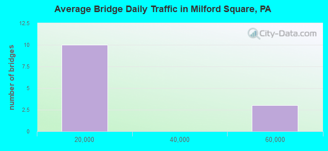
- 182,383Total average daily traffic
- 25,685Total average daily truck traffic
- National Bridge Inventory (NBI) Registered Bridges for Milford Square
- No street view available for this location
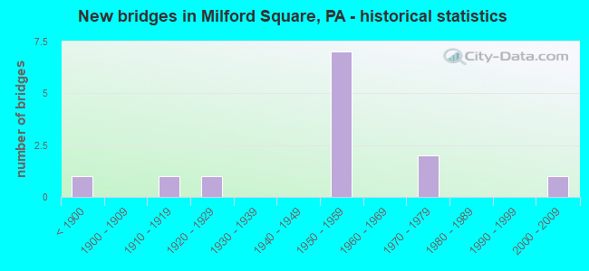
- New bridges - historical statistics
- 1Before 1900
- 11910-1919
- 11920-1929
- 71950-1959
- 21970-1979
- 12000-2009
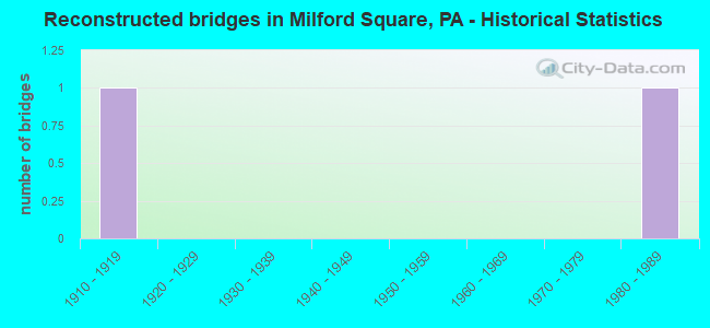
- Reconstructed bridges - Historical Statistics
- 11910-1919
- 01920-1929
- 01930-1939
- 01940-1949
- 01950-1959
- 01960-1969
- 01970-1979
- 11980-1989
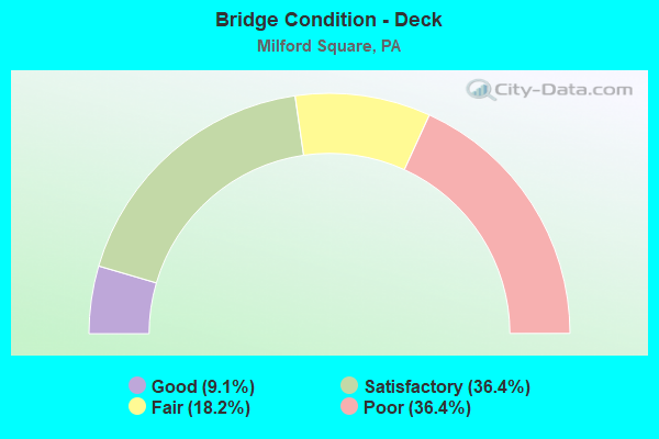
- Bridge Condition - Deck
- 9.1%Good
- 36.4%Satisfactory
- 18.2%Fair
- 36.4%Poor
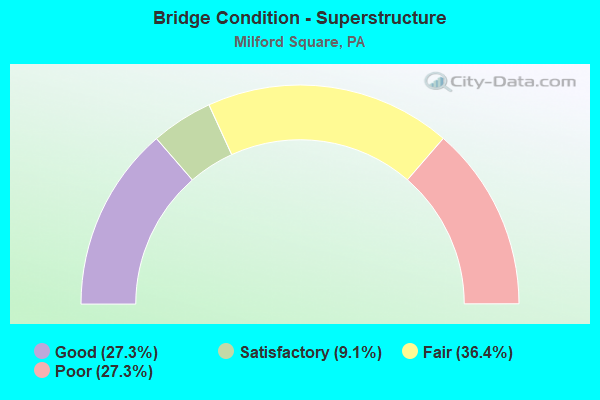
- Bridge Condition - Superstructure
- 27.3%Good
- 9.1%Satisfactory
- 36.4%Fair
- 27.3%Poor
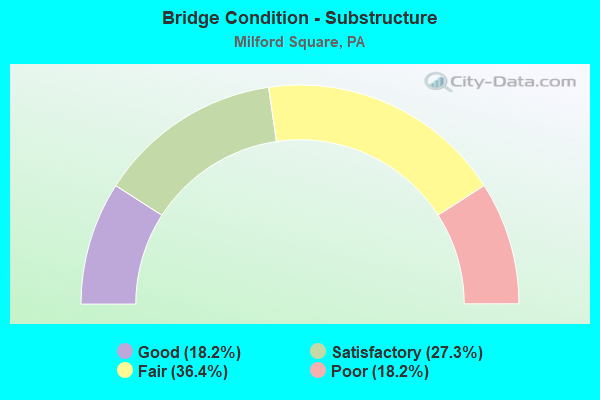
- Bridge Condition - Substructure
- 18.2%Good
- 27.3%Satisfactory
- 36.4%Fair
- 18.2%Poor
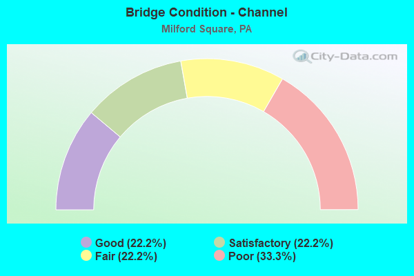
- Bridge Condition - Channel
- 22.2%Good
- 22.2%Satisfactory
- 22.2%Fair
- 33.3%Poor
Find on map >> Show street view
Structure Number: 743, Location: .3MI.E.PA.TPK.NE. 12K06 (Lat: 40.415269, Lng: -75.409414), Route carried "on" structure: State highway , Year Built: 1890, Year Reconstructed: 1921, Status: Posted for load, Structure Length: 5.12m (16.80ft), Average Daily Traffic: 2,441 (year 2022), Truck Traffic: 9%, Average Future Daily Traffic: 3,498 (year 2032), Design Load: H 15, Features Intersected: UNAMI CREEK / 2806-E4, Facility Carried by Structure: KUMRY ROAD
Minimum Vertical Clearance: 30+ m (98+ ft), Kilometerpoint: 4.793, Lanes on structure: 1, Owner: State Highway Agency, Approaching Roadway Width: 7.9m (25.9ft), Material/Design: Steel, Design/Construction: Stringer/Multi-beam, Number Of Spans In Main Unit: 5, Length of Maximum Span: 6.1m (20.0ft), Curb-To-Curb Width: 4.7m (15.4ft), Out-to-Out Width: 5.8m (19.0ft)
Condition: Deck: Poor, Superstructure: Poor, Substructure: Fair, Channel: Poor, Operating Rating: 47.2 metric tons, Method Used To Determine Operating Rating: Load Factor (LF), Inventory Rating: 28.1 metric tons, Method Used To Determine Inventory Rating: Load Factor (LF), Structural Evaluation: Meets minimum limits, Deck Geometry: High priority of replacement, Waterway Adequacy: Better than present minimum criteria, Approach Roadway Alignment: Somewhat better than minimum adequacy, Length Of Structure Improvement: 6.10m (20.01ft), Designated Inspection Frequency: Every 24 months, Other Special Inspection Frequency: Every 12 months, Inspection Date: June 2020, Other Special Inspection Date: June 2021, Bridge Improvement Cost: $108,000, Roadway Improvement Cost: $400,000, Total Project Cost: $1,461,000, Deck Structure Type: Concrete Cast-file-Place, Wearing Surface/Protective System: Wearing Surface: Bituminous
Find on map >> Show street view
Structure Number: 7577, Location: MILFORD TWP 2694-H8 ADC (Lat: 40.452514, Lng: -75.392428), Route carried "on" structure: City street , Year Built: 1910, Status: Posted for load, Structure Length: 3.05m (10.01ft), Average Daily Traffic: 150 (year 2000), Average Future Daily Traffic: 210 (year 2011), Features Intersected: SWAMP CREEK(UNAMI), Facility Carried by Structure: MILL POND ROAD
Minimum Vertical Clearance: 30+ m (98+ ft), Kilometerpoint: 0.000, Lanes on structure: 1, Owner: County Highway Agency, Approaching Roadway Width: 4.9m (16.1ft), Skew: 1 degrees, Material/Design: Concrete, Design/Construction: Slab, Number Of Spans In Main Unit: 3, Length of Maximum Span: 8.8m (28.9ft), Curb-To-Curb Width: 5.0m (16.4ft), Out-to-Out Width: 5.8m (19.0ft)
Condition: Deck: Poor, Superstructure: Poor, Substructure: Poor, Channel: Poor, Operating Rating: 30.8 metric tons, Method Used To Determine Operating Rating: Field evaluation and documented engineering judgment, Inventory Rating: 18.1 metric tons, Method Used To Determine Inventory Rating: Field evaluation and documented engineering judgment, Structural Evaluation: Meets minimum limits, Deck Geometry: High priority of replacement, Waterway Adequacy: Somewhat better than minimum adequacy, Approach Roadway Alignment: Equal to present desirable criteria, Bridge Posting: Required (Relationship of Operating Rating to Maximum Legal Load: 30.0 - 39.9% below), Length Of Structure Improvement: 3.00m (9.84ft), Designated Inspection Frequency: Every 24 months, Other Special Inspection Frequency: Every 12 months, Inspection Date: June 2020, Other Special Inspection Date: June 2021, Bridge Improvement Cost: $60,000, Roadway Improvement Cost: $350,000, Total Project Cost: $804,000, Wearing Surface/Protective System: Wearing Surface: Bituminous
Find on map >> Show street view
Structure Number: 7582, Location: 2 Mi E TPKE INT 2806-H1 (Lat: 40.437061, Lng: -75.392928), Route carried "on" structure: City street , Year Built: 1924, Status: Open, Structure Length: 1.68m (5.51ft), Average Daily Traffic: 1,000 (year 2000), Truck Traffic: 5%, Average Future Daily Traffic: 700 (year 2016), Features Intersected: Unami Creek, Facility Carried by Structure: Milford Square Pk
Minimum Vertical Clearance: 30+ m (98+ ft), Kilometerpoint: 0.000, Lanes on structure: 2, Owner: County Highway Agency, Approaching Roadway Width: 6.4m (21.0ft), Material/Design: Steel, Design/Construction: Stringer/Multi-beam, Number Of Spans In Main Unit: 1, Length of Maximum Span: 7.9m (25.9ft), Curb-To-Curb Width: 7.4m (24.3ft), Out-to-Out Width: 7.9m (25.9ft)
Condition: Deck: Satisfactory, Superstructure: Good, Substructure: Satisfactory, Channel: Satisfactory, Operating Rating: 59.0 metric tons, Method Used To Determine Operating Rating: Load Factor (LF), Inventory Rating: 35.4 metric tons, Method Used To Determine Inventory Rating: Load Factor (LF), Structural Evaluation: Equal to present minimum criteria, Deck Geometry: Meets minimum limits, Waterway Adequacy: Equal to present desirable criteria, Approach Roadway Alignment: Somewhat better than minimum adequacy, Length Of Structure Improvement: 1.60m (5.25ft), Designated Inspection Frequency: Every 24 months, Inspection Date: May 2020, Bridge Improvement Cost: $9,000, Roadway Improvement Cost: $28,000, Total Project Cost: $126,000, Deck Structure Type: Concrete Cast-file-Place, Wearing Surface/Protective System: Wearing Surface: Bituminous
Find on map >> Show street view
Structure Number: 7618, Location: 3700 FT N. PA 663 2694-D9 (Lat: 40.444514, Lng: -75.415436), Route carried "on" structure: City street , Year Built: 1970, Status: Posted for load, Structure Length: 0.70m (2.30ft), Average Daily Traffic: 500 (year 2015), Truck Traffic: 2%, Average Future Daily Traffic: 600 (year 2035), Design Load: HS 20, Features Intersected: LICKING CREEK, Facility Carried by Structure: WEISS ROAD
Minimum Vertical Clearance: 30+ m (98+ ft), Kilometerpoint: 0.000, Lanes on structure: 2, Owner: Town or Township Highway Agency, Approaching Roadway Width: 6.1m (20.0ft), Material/Design: Prestressed concrete, Design/Construction: Slab, Number Of Spans In Main Unit: 1, Length of Maximum Span: 6.4m (21.0ft), Curb-To-Curb Width: 6.8m (22.3ft), Out-to-Out Width: 7.4m (24.3ft)
Condition: Deck: Poor, Superstructure: Poor, Substructure: Poor, Channel: Poor, Operating Rating: 30.8 metric tons, Method Used To Determine Operating Rating: Load Factor (LF), Inventory Rating: 24.5 metric tons, Method Used To Determine Inventory Rating: Load Factor (LF), Structural Evaluation: Meets minimum limits, Deck Geometry: Meets minimum limits, Waterway Adequacy: Somewhat better than minimum adequacy, Approach Roadway Alignment: Better than present minimum criteria, Bridge Posting: Required (Relationship of Operating Rating to Maximum Legal Load: 30.0 - 39.9% below), Length Of Structure Improvement: 0.90m (2.95ft), Designated Inspection Frequency: Every 24 months, Other Special Inspection Frequency: Every 12 months, Inspection Date: Febuary 2021, Other Special Inspection Date: Febuary 2021, Deck Structure Type: Concrete Precast Panels, Wearing Surface/Protective System: Wearing Surface: Bituminous
Find on map >> Show street view
Structure Number: 7619, Location: 1.8 MI E OF SR663 2806-D4 (Lat: 40.416639, Lng: -75.416972), Route carried "on" structure: City street , Year Built: 1955, Status: Posted for load, Structure Length: 0.79m (2.59ft), Average Daily Traffic: 75 (year 2015), Truck Traffic: 1%, Average Future Daily Traffic: 100 (year 2035), Design Load: HS 20, Features Intersected: SCHMOUTZ CREEK, Facility Carried by Structure: WALNUT LANE
Minimum Vertical Clearance: 30+ m (98+ ft), Kilometerpoint: 0.000, Lanes on structure: 1, Owner: Town or Township Highway Agency, Approaching Roadway Width: 4.0m (13.1ft), Material/Design: Steel, Design/Construction: Stringer/Multi-beam, Number Of Spans In Main Unit: 1, Length of Maximum Span: 7.6m (24.9ft), Curb-To-Curb Width: 4.8m (15.7ft), Out-to-Out Width: 4.9m (16.1ft)
Condition: Deck: Fair, Superstructure: Fair, Substructure: Satisfactory, Channel: Fair, Operating Rating: 44.5 metric tons, Method Used To Determine Operating Rating: Load Factor (LF), Inventory Rating: 26.3 metric tons, Method Used To Determine Inventory Rating: Load Factor (LF), Structural Evaluation: Somewhat better than minimum adequacy, Deck Geometry: Equal to present desirable criteria, Waterway Adequacy: Equal to present minimum criteria, Approach Roadway Alignment: Somewhat better than minimum adequacy, Bridge Posting: Required (Relationship of Operating Rating to Maximum Legal Load: 10.0 - 19.9% below), Length Of Structure Improvement: 1.00m (3.28ft), Designated Inspection Frequency: Every 24 months, Other Special Inspection Frequency: Every 12 months, Inspection Date: July 2020, Other Special Inspection Date: July 2020, Deck Structure Type: Open Grating
Find on map >> Show street view
Structure Number: 7621, Location: 3.5 MI E OFSR 663 2806-D5 (Lat: 40.410461, Lng: -75.414019), Route carried "on" structure: City street , Year Built: 1955, Status: Open, Structure Length: 1.89m (6.20ft), Average Daily Traffic: 150 (year 2018), Truck Traffic: 3%, Average Future Daily Traffic: 200 (year 2038), Features Intersected: SCHMOUTZ CREEK, Facility Carried by Structure: DOERR ROAD
Minimum Vertical Clearance: 30+ m (98+ ft), Kilometerpoint: 0.000, Lanes on structure: 2, Owner: Town or Township Highway Agency, Approaching Roadway Width: 5.2m (17.1ft), Skew: 3 degrees, Material/Design: Concrete, Design/Construction: Tee Beam, Number Of Spans In Main Unit: 1, Length of Maximum Span: 14.3m (46.9ft), Curb or Sidewalk Widths: Left: 0.2m (0.7ft), Right: 0.2m (0.7ft), Curb-To-Curb Width: 8.6m (28.2ft), Out-to-Out Width: 9.9m (32.5ft)
Condition: Deck: Satisfactory, Superstructure: Good, Substructure: Good, Channel: Satisfactory, Operating Rating: 70.8 metric tons, Method Used To Determine Operating Rating: Field evaluation and documented engineering judgment, Inventory Rating: 41.7 metric tons, Method Used To Determine Inventory Rating: Field evaluation and documented engineering judgment, Structural Evaluation: Better than present minimum criteria, Deck Geometry: Equal to present minimum criteria, Waterway Adequacy: Equal to present desirable criteria, Approach Roadway Alignment: Equal to present minimum criteria, Length Of Structure Improvement: 2.30m (7.55ft), Designated Inspection Frequency: Every 24 months, Inspection Date: July 2020, Deck Structure Type: Concrete Cast-file-Place, Wearing Surface/Protective System: Wearing Surface: Monolithic Concrete
Find on map >> Show street view
Structure Number: 7705, Location: WEST OF TRUMBAUERSVILLE (Lat: 40.417944, Lng: -75.414764), Route carried "on" structure: Interstate 476, Year Built: 1955, Status: Open, Structure Length: 4.88m (16.01ft), Average Daily Traffic: 50,307 (year 2004), Truck Traffic: 15%, Average Future Daily Traffic: 78,780 (year 2030), Design Load: HS 20, Features Intersected: SR 4055, LR 09109
Minimum Vertical Clearance: 30+ m (98+ ft), Kilometerpoint: 0.000, Lanes on structure: 4, Lanes under structure: 2, Base Highway Network: Yes, Toll: On toll road, Owner: State Toll Authority, Approaching Roadway Width: 17.7m (58.1ft), Skew: 35 degrees, Material/Design: Steel continuous, Design/Construction: Stringer/Multi-beam, Number Of Spans In Main Unit: 3, Length of Maximum Span: 19.2m (63.0ft), Curb or Sidewalk Widths: Left: 0.2m (0.7ft), Right: 0.2m (0.7ft), Curb-To-Curb Width: 16.9m (55.4ft), Out-to-Out Width: 19.2m (63.0ft)
Condition: Deck: Fair, Superstructure: Fair, Substructure: Fair, Operating Rating: 54.4 metric tons, Method Used To Determine Operating Rating: Load Factor (LF), Inventory Rating: 32.7 metric tons, Method Used To Determine Inventory Rating: Load Factor (LF), Structural Evaluation: Somewhat better than minimum adequacy, Deck Geometry: High priority of replacement, Underclear: High priority of corrective action, Approach Roadway Alignment: Equal to present desirable criteria, Length Of Structure Improvement: 7.10m (23.29ft), Designated Inspection Frequency: Every 24 months, Inspection Date: September 2019, Bridge Improvement Cost: $33,000, Roadway Improvement Cost: $96,000, Total Project Cost: $441,000, Deck Structure Type: Concrete Cast-file-Place, Wearing Surface/Protective System: Wearing Surface: Latex Concrete
Find on map >> Show street view
Structure Number: 7706, Location: S OF QUAKERTOWN INTERCH. (Lat: 40.429178, Lng: -75.419453), Route carried "on" structure: Interstate 476, Year Built: 1955, Status: Open, Structure Length: 0.82m (2.69ft), Average Daily Traffic: 50,307 (year 2004), Truck Traffic: 15%, Average Future Daily Traffic: 78,780 (year 2030), Design Load: HS 20, Features Intersected: MOLASSES CREEK
Minimum Vertical Clearance: 30+ m (98+ ft), Kilometerpoint: 0.000, Lanes on structure: 4, Base Highway Network: Yes, Toll: On toll road, Owner: State Toll Authority, Approaching Roadway Width: 21.3m (69.9ft), Skew: 31 degrees, Material/Design: Concrete, Design/Construction: Tee Beam, Number Of Spans In Main Unit: 1, Length of Maximum Span: 8.2m (26.9ft), Curb-To-Curb Width: 21.0m (68.9ft), Out-to-Out Width: 25.3m (83.0ft)
Condition: Deck: Satisfactory, Superstructure: Satisfactory, Substructure: Satisfactory, Channel: Fair, Operating Rating: 42.6 metric tons, Method Used To Determine Operating Rating: Load Factor (LF), Inventory Rating: 25.4 metric tons, Method Used To Determine Inventory Rating: Load Factor (LF), Structural Evaluation: Equal to present minimum criteria, Deck Geometry: Better than present minimum criteria, Waterway Adequacy: Superior to present desirable criteria, Approach Roadway Alignment: Equal to present desirable criteria, Length Of Structure Improvement: 1.60m (5.25ft), Designated Inspection Frequency: Every 24 months, Inspection Date: October 2019
Find on map >> Show street view
Structure Number: 7707, Location: QUAKERTOWN INTERCHANGE (Lat: 40.434608, Lng: -75.423503), Route carried "on" structure: State highway 663, Year Built: 1955, Year Reconstructed: 1988, Status: Open, Structure Length: 4.75m (15.58ft), Average Daily Traffic: 19,455 (year 2022), Truck Traffic: 11%, Average Future Daily Traffic: 23,011 (year 2030), Design Load: HS 20, Features Intersected: PA TPK (I-476)
Minimum Vertical Clearance: 30+ m (98+ ft), Kilometerpoint: 4.952, Lanes on structure: 4, Lanes under structure: 4, Base Highway Network: Yes, Owner: State Toll Authority, Approaching Roadway Width: 19.8m (65.0ft), Skew: 22 degrees, Material/Design: Steel continuous, Design/Construction: Stringer/Multi-beam, Number Of Spans In Main Unit: 3, Length of Maximum Span: 26.8m (87.9ft), Curb or Sidewalk Widths: Left: 0.5m (1.6ft), Right: 0.5m (1.6ft), Curb-To-Curb Width: 18.0m (59.1ft), Out-to-Out Width: 20.7m (67.9ft)
Condition: Deck: Poor, Superstructure: Fair, Substructure: Fair, Operating Rating: 59.9 metric tons, Method Used To Determine Operating Rating: Load Factor (LF), Inventory Rating: 36.3 metric tons, Method Used To Determine Inventory Rating: Load Factor (LF), Structural Evaluation: Somewhat better than minimum adequacy, Deck Geometry: Somewhat better than minimum adequacy, Underclear: High priority of corrective action, Approach Roadway Alignment: Equal to present desirable criteria, Length Of Structure Improvement: 5.70m (18.70ft), Designated Inspection Frequency: Every 24 months, Critical Feature Inspection Frequency: Every 24 months, Inspection Date: October 2019, Critical Feature Inspection Date: October 2019, Bridge Improvement Cost: $127,000, Roadway Improvement Cost: $374,000, Total Project Cost: $1,715,000, Deck Structure Type: Concrete Cast-file-Place, Wearing Surface/Protective System: Wearing Surface: Bituminous
Find on map >> Show street view
Structure Number: 1043, Location: NEW GARDEN 54F2 (Lat: 39.783297, Lng: -75.774925), Route carried "on" structure: State highway , Year Built: 1974, Status: Open, Structure Length: 9.20m (30.18ft), Average Daily Traffic: 2,220 (year 2022), Truck Traffic: 6%, Average Future Daily Traffic: 2,918 (year 2032), Design Load: HS 20, Features Intersected: WHITE CLAY CREEK, Facility Carried by Structure: PENN GREEN ROAD
Minimum Vertical Clearance: 30+ m (98+ ft), Kilometerpoint: 1.291, Lanes on structure: 2, Owner: State Highway Agency, Approaching Roadway Width: 9.1m (29.9ft), Skew: 1 degrees, Material/Design: Prestressed concrete, Design/Construction: Box Beam or Girders - Multiple, Number Of Spans In Main Unit: 4, Length of Maximum Span: 22.6m (74.1ft), Curb-To-Curb Width: 9.1m (29.9ft), Out-to-Out Width: 10.4m (34.1ft)
Condition: Deck: Satisfactory, Superstructure: Fair, Substructure: Fair, Channel: Good, Inventory Rating: 42.6 metric tons, Method Used To Determine Inventory Rating: Load Factor (LF), Structural Evaluation: Somewhat better than minimum adequacy, Deck Geometry: Meets minimum limits, Waterway Adequacy: Superior to present desirable criteria, Approach Roadway Alignment: Somewhat better than minimum adequacy, Length Of Structure Improvement: 10.20m (33.46ft), Designated Inspection Frequency: Every 24 months, Inspection Date: April 2020, Deck Structure Type: Concrete Cast-file-Place, Wearing Surface/Protective System: Wearing Surface: Monolithic Concrete, Deck Protection: Galvanized Reinforcing
Find on map >> Show street view
Structure Number: 4317, Location: .7MI.SOUTH PA 663 13B03 (Lat: 40.428375, Lng: -75.396583), Route carried "on" structure: State highway , Year Built: 2005, Status: Open, Structure Length: 3.84m (12.60ft), Average Daily Traffic: 3,030 (year 2020), Truck Traffic: 9%, Average Future Daily Traffic: 3,818 (year 2032), Design Load: HL 93, Features Intersected: UNAMI CREEK, Facility Carried by Structure: ALLENTOWN ROAD
Minimum Vertical Clearance: 30+ m (98+ ft), Kilometerpoint: 17.770, Lanes on structure: 2, Owner: State Highway Agency, Approaching Roadway Width: 10.4m (34.1ft), Material/Design: Prestressed concrete continuous, Design/Construction: Box Beam or Girders - Single/Spread, Number Of Spans In Main Unit: 2, Length of Maximum Span: 21.9m (71.9ft), Curb or Sidewalk Widths: Left: 0.2m (0.7ft), Right: 0.2m (0.7ft), Curb-To-Curb Width: 9.8m (32.2ft), Out-to-Out Width: 10.7m (35.1ft)
Condition: Deck: Good, Superstructure: Good, Substructure: Good, Channel: Good, Inventory Rating: 59.9 metric tons, Method Used To Determine Inventory Rating: Load Factor (LF), Structural Evaluation: Better than present minimum criteria, Deck Geometry: Meets minimum limits, Waterway Adequacy: Equal to present desirable criteria, Approach Roadway Alignment: Better than present minimum criteria, Designated Inspection Frequency: Every 24 months, Inspection Date: December 2019, Deck Structure Type: Concrete Cast-file-Place, Wearing Surface/Protective System: Wearing Surface: Monolithic Concrete, Deck Protection: Epoxy Coated Reinforcing
Find on map >> Show street view
Structure Number: 7705, Location: WEST OF TRUMBAUERSVILLE (Lat: 40.417944, Lng: -75.414764), Route carried "under" structure: State highway , Year Built: 1955, Structure Length: 0. m, Average Daily Traffic: 2,441 (year 2022), Truck Traffic: 9%, Features Intersected: SR 4055, LR 09109, Facility Carried by Structure: PA TPK (I-476)
Minimum Vertical Clearance: 6.02m (19.75ft), Kilometerpoint: 3.898, Lanes on structure: 4, Lanes under structure: 2, Material/Design: Steel continuous, Design/Construction: Stringer/Multi-beam, Length of Maximum Span: 19.2m (63.0ft)
Find on map >> Show street view
Structure Number: 7707, Location: QUAKERTOWN INTERCHANGE (Lat: 40.434608, Lng: -75.423503), Route carried "under" structure: Interstate 476, Year Built: 1955, Structure Length: 0. m, Average Daily Traffic: 50,307 (year 2004), Truck Traffic: 15%, Features Intersected: PA TPK (I-476), Facility Carried by Structure: SR 0663, LR 923
Minimum Vertical Clearance: 4.47m (14.67ft), Kilometerpoint: 0.000, Lanes on structure: 4, Lanes under structure: 4, Material/Design: Steel continuous, Design/Construction: Stringer/Multi-beam, Length of Maximum Span: 26.8m (87.9ft)