Bridge Statistics for Millburn, New Jersey (NJ)
Condition, Traffic, Stress, Structural Evaluation, Project Costs
- National Bridge Inventory (NBI) Statistics
- 26Number of bridges
- 154ft / 47.0mTotal length
- $13,770,000Total costs
- 1,037,099Total average daily traffic
- 49,236Total average daily truck traffic
- National Bridge Inventory (NBI) Registered Bridges for Millburn
- No street view available for this location
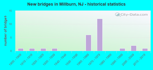
- New bridges - historical statistics
- 11900-1909
- 11910-1919
- 11920-1929
- 11930-1939
- 61960-1969
- 121970-1979
- 11990-1999
- 22000-2009
- 12010-2019
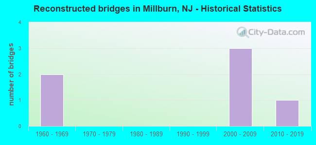
- Reconstructed bridges - Historical Statistics
- 21960-1969
- 01970-1979
- 01980-1989
- 01990-1999
- 32000-2009
- 12010-2019
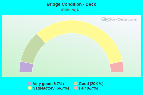
- Bridge Condition - Deck
- 6.7%Very good
- 20.0%Good
- 66.7%Satisfactory
- 6.7%Fair
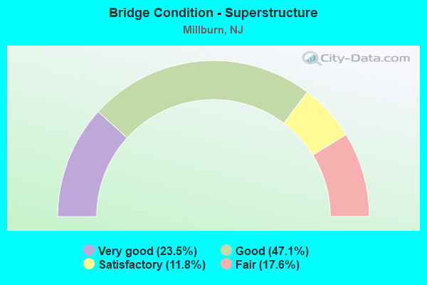
- Bridge Condition - Superstructure
- 23.5%Very good
- 47.1%Good
- 11.8%Satisfactory
- 17.6%Fair
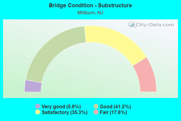
- Bridge Condition - Substructure
- 5.9%Very good
- 41.2%Good
- 35.3%Satisfactory
- 17.6%Fair
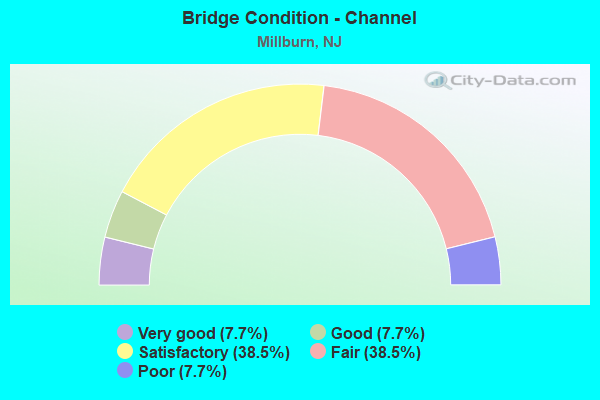
- Bridge Condition - Channel
- 7.7%Very good
- 7.7%Good
- 38.5%Satisfactory
- 38.5%Fair
- 7.7%Poor
Find on map >> Show street view
Structure Number: 700002, Location: .45 MI S.OF SO. OF CR 510 (Lat: 40.756781, Lng: -74.330531), Route carried "on" structure: County highway 649, Year Built: 1964, Status: Open, Structure Length: 1.34m (4.40ft), Average Daily Traffic: 24,311 (year 2020), Truck Traffic: 4%, Average Future Daily Traffic: 29,659 (year 2040), Design Load: HS 20, Features Intersected: CANOE BROOK
Minimum Vertical Clearance: 30+ m (98+ ft), Kilometerpoint: 4.233, Lanes on structure: 4, Base Highway Network: Yes, Owner: County Highway Agency, Approaching Roadway Width: 21.9m (71.9ft), Skew: 30 degrees, Material/Design: Prestressed concrete, Design/Construction: Slab, Number Of Spans In Main Unit: 1, Length of Maximum Span: 12.5m (41.0ft), Curb or Sidewalk Widths: Left: 1.2m (3.9ft), Right: 1.2m (3.9ft), Curb-To-Curb Width: 21.9m (71.9ft), Out-to-Out Width: 25.6m (84.0ft)
Condition: Deck: Satisfactory, Superstructure: Satisfactory, Substructure: Fair, Channel: Poor, Operating Rating: 78.0 metric tons, Method Used To Determine Operating Rating: Load Factor (LF), Inventory Rating: 46.3 metric tons, Method Used To Determine Inventory Rating: Load Factor (LF), Structural Evaluation: Somewhat better than minimum adequacy, Deck Geometry: Superior to present desirable criteria, Waterway Adequacy: Equal to present minimum criteria, Approach Roadway Alignment: Equal to present desirable criteria, Length Of Structure Improvement: 1.34m (4.40ft), Designated Inspection Frequency: Every 24 months, Underwater Inspection Frequency: Every 24 months, Inspection Date: August 2020, Underwater Inspection Date: September 2020, Deck Structure Type: Concrete Precast Panels, Wearing Surface/Protective System: Wearing Surface: Bituminous, Membrane: Other
Find on map >> Show street view
Structure Number: 700003, Location: .61 MI S.OF CR 510 (Lat: 40.754611, Lng: -74.329889), Route carried "on" structure: County highway 649, Year Built: 1964, Status: Open, Structure Length: 0.79m (2.59ft), Average Daily Traffic: 24,311 (year 2020), Truck Traffic: 4%, Average Future Daily Traffic: 29,659 (year 2040), Design Load: HS 20, Features Intersected: TAYLOR BROOK
Minimum Vertical Clearance: 30+ m (98+ ft), Kilometerpoint: 3.991, Lanes on structure: 4, Base Highway Network: Yes, Owner: County Highway Agency, Approaching Roadway Width: 21.9m (71.9ft), Skew: 30 degrees, Material/Design: Prestressed concrete, Design/Construction: Slab, Number Of Spans In Main Unit: 1, Length of Maximum Span: 7.0m (23.0ft), Curb or Sidewalk Widths: Left: 1.2m (3.9ft), Right: 1.2m (3.9ft), Curb-To-Curb Width: 21.9m (71.9ft), Out-to-Out Width: 25.6m (84.0ft)
Condition: Deck: Fair, Superstructure: Fair, Substructure: Fair, Channel: Fair, Operating Rating: 71.7 metric tons, Method Used To Determine Operating Rating: Load Factor (LF), Inventory Rating: 42.6 metric tons, Method Used To Determine Inventory Rating: Load Factor (LF), Structural Evaluation: Somewhat better than minimum adequacy, Deck Geometry: Superior to present desirable criteria, Waterway Adequacy: Equal to present minimum criteria, Approach Roadway Alignment: Better than present minimum criteria, Length Of Structure Improvement: 0.79m (2.59ft), Designated Inspection Frequency: Every 24 months, Underwater Inspection Frequency: Every 24 months, Inspection Date: August 2020, Underwater Inspection Date: September 2020, Deck Structure Type: Concrete Precast Panels, Wearing Surface/Protective System: Wearing Surface: Bituminous, Membrane: Other
Find on map >> Show street view
Structure Number: 700027, Location: 40FT EAST OF MAIN STREET (Lat: 40.724069, Lng: -74.306919), Route carried "on" structure: County highway 577, Year Built: 2011, Status: Open, Structure Length: 1.80m (5.91ft), Average Daily Traffic: 10,958 (year 2020), Truck Traffic: 4%, Average Future Daily Traffic: 13,368 (year 2040), Design Load: HS 25 or greater, Features Intersected: W. BR. RAHWAY RIVER
Minimum Vertical Clearance: 30+ m (98+ ft), Kilometerpoint: 6.566, Lanes on structure: 3, Base Highway Network: Yes, Owner: County Highway Agency, Approaching Roadway Width: 15.2m (49.9ft), Material/Design: Concrete, Design/Construction: Arch - Deck, Number Of Spans In Main Unit: 2, Length of Maximum Span: 8.5m (27.9ft), Curb or Sidewalk Widths: Left: 2.6m (8.5ft), Right: 2.6m (8.5ft), Curb-To-Curb Width: 15.2m (49.9ft), Out-to-Out Width: 21.5m (70.5ft)
Condition: Superstructure: Very good, Substructure: Very good, Channel: Fair, Operating Rating: 58.1 metric tons, Method Used To Determine Operating Rating: Load Factor (LF), Inventory Rating: 34.5 metric tons, Method Used To Determine Inventory Rating: Load Factor (LF), Structural Evaluation: Equal to present desirable criteria, Deck Geometry: Equal to present minimum criteria, Waterway Adequacy: Equal to present minimum criteria, Approach Roadway Alignment: Equal to present desirable criteria, Designated Inspection Frequency: Every 24 months, Inspection Date: September 2020
Find on map >> Show street view
Structure Number: 700053, Location: 1 mi East of CR 527 (Lat: 40.728719, Lng: -74.307831), Route carried "on" structure: City street , Year Built: 1908, Year Reconstructed: 2014, Status: Open, Structure Length: 1.55m (5.09ft), Average Daily Traffic: 4,029 (year 2021), Truck Traffic: 1%, Average Future Daily Traffic: 4,835 (year 2041), Design Load: HL 93, Features Intersected: West Branch Rahway River, Facility Carried by Structure: Glen Avenue
Minimum Vertical Clearance: 30+ m (98+ ft), Kilometerpoint: 0.000, Lanes on structure: 2, Owner: County Highway Agency, Approaching Roadway Width: 11.0m (36.1ft), Skew: 1 degrees, Material/Design: Steel, Design/Construction: Stringer/Multi-beam, Number Of Spans In Main Unit: 1, Length of Maximum Span: 13.7m (44.9ft), Curb or Sidewalk Widths: Left: 2.0m (6.6ft), Right: 2.6m (8.5ft), Curb-To-Curb Width: 11.0m (36.1ft), Out-to-Out Width: 16.6m (54.5ft)
Condition: Deck: Very good, Superstructure: Very good, Substructure: Good, Channel: Fair, Operating Rating: 74.2 metric tons, Method Used To Determine Operating Rating: Load and Resistance Factor Rating (LRFR) rating reported by rating factor(RF) method using HL-93 loadings, Inventory Rating: 57.3 metric tons, Method Used To Determine Inventory Rating: Load and Resistance Factor Rating (LRFR) rating reported by rating factor(RF) method using HL-93 loadings, Structural Evaluation: Better than present minimum criteria, Deck Geometry: Somewhat better than minimum adequacy, Waterway Adequacy: Better than present minimum criteria, Approach Roadway Alignment: Equal to present minimum criteria, Designated Inspection Frequency: Every 24 months, Inspection Date: July 2021, Deck Structure Type: Concrete Cast-file-Place, Wearing Surface/Protective System: Wearing Surface: Monolithic Concrete, Deck Protection: Galvanized Reinforcing
Find on map >> Show street view
Structure Number: 700054, Location: 0.2M EAST OF MAIN STREET (Lat: 40.720489, Lng: -74.306661), Route carried "on" structure: City street , Year Built: 2003, Status: Open, Structure Length: 1.40m (4.59ft), Average Daily Traffic: 2,732 (year 2020), Truck Traffic: 3%, Average Future Daily Traffic: 3,333 (year 2040), Design Load: HS 20, Features Intersected: WEST BRANCH RAHWAY RIVER, Facility Carried by Structure: RIDGEWOOD ROAD
Minimum Vertical Clearance: 30+ m (98+ ft), Kilometerpoint: 0.000, Lanes on structure: 2, Owner: County Highway Agency, Approaching Roadway Width: 9.1m (29.9ft), Material/Design: Prestressed concrete, Design/Construction: Box Beam or Girders - Multiple, Number Of Spans In Main Unit: 1, Length of Maximum Span: 12.5m (41.0ft), Curb or Sidewalk Widths: Left: 3.4m (11.2ft), Right: 3.4m (11.2ft), Curb-To-Curb Width: 9.1m (29.9ft), Out-to-Out Width: 16.6m (54.5ft)
Condition: Deck: Good, Superstructure: Good, Substructure: Good, Channel: Fair, Operating Rating: 82.6 metric tons, Method Used To Determine Operating Rating: Load Factor (LF), Inventory Rating: 49.9 metric tons, Method Used To Determine Inventory Rating: Load Factor (LF), Structural Evaluation: Better than present minimum criteria, Deck Geometry: Meets minimum limits, Waterway Adequacy: Better than present minimum criteria, Approach Roadway Alignment: Equal to present desirable criteria, Designated Inspection Frequency: Every 24 months, Inspection Date: August 2020, Deck Structure Type: Concrete Cast-file-Place, Wearing Surface/Protective System: Wearing Surface: Latex Concrete, Deck Protection: Epoxy Coated Reinforcing
Find on map >> Show street view
Structure Number: 700107, Location: 1 MI EAST OF RT 527 JCT (Lat: 40.753669, Lng: -74.292669), Route carried "on" structure: County highway 510, Year Built: 1991, Year Reconstructed: 2016, Status: Open, Structure Length: 1.43m (4.69ft), Average Daily Traffic: 18,407 (year 2021), Truck Traffic: 4%, Average Future Daily Traffic: 22,088 (year 2041), Design Load: HS 20+Mod, Features Intersected: WEST BRANCH RAHWAY RIVER, Facility Carried by Structure: South Orange Ave.
Minimum Vertical Clearance: 30+ m (98+ ft), Kilometerpoint: 36.001, Lanes on structure: 3, Base Highway Network: Yes, Owner: County Highway Agency, Approaching Roadway Width: 16.6m (54.5ft), Skew: 32 degrees, Material/Design: Concrete, Design/Construction: Culvert, Number Of Spans In Main Unit: 2, Length of Maximum Span: 6.1m (20.0ft), Curb or Sidewalk Widths: Left: 1.8m (5.9ft), Right: 0.9m (3.0ft), Curb-To-Curb Width: 16.6m (54.5ft), Out-to-Out Width: 21.8m (71.5ft)
Condition: Channel: Very good, Culverts: Satisfactory, Inventory Rating: 58.1 metric tons, Method Used To Determine Inventory Rating: Load Factor (LF), Structural Evaluation: Equal to present minimum criteria, Deck Geometry: Equal to present desirable criteria, Waterway Adequacy: Equal to present desirable criteria, Approach Roadway Alignment: Equal to present minimum criteria, Designated Inspection Frequency: Every 24 months, Inspection Date: July 2021
Find on map >> Show street view
Structure Number: 700365, Location: 1.5 mi N of RT 527 (Lat: 40.748281, Lng: -74.336381), Route carried "on" structure: County highway 606, Year Built: 1963, Year Reconstructed: 2012, Status: Open, Structure Length: 2.41m (7.91ft), Average Daily Traffic: 11,602 (year 2021), Truck Traffic: 3%, Average Future Daily Traffic: 13,992 (year 2041), Design Load: HL 93, Features Intersected: JFK Parkway (CR 649), Facility Carried by Structure: Parsonage Hill Rd.
Minimum Vertical Clearance: 30+ m (98+ ft), Kilometerpoint: 2.430, Lanes on structure: 2, Lanes under structure: 4, Owner: County Highway Agency, Approaching Roadway Width: 13.7m (44.9ft), Material/Design: Prestressed concrete, Design/Construction: Slab, Number Of Spans In Main Unit: 2, Length of Maximum Span: 11.3m (37.1ft), Curb or Sidewalk Widths: Left: 1.8m (5.9ft), Right: 1.2m (3.9ft), Curb-To-Curb Width: 13.7m (44.9ft), Out-to-Out Width: 17.5m (57.4ft)
Condition: Deck: Satisfactory, Superstructure: Good, Substructure: Good, Operating Rating: 62.2 metric tons, Method Used To Determine Operating Rating: Load and Resistance Factor Rating (LRFR) rating reported by rating factor(RF) method using HL-93 loadings, Inventory Rating: 48.0 metric tons, Method Used To Determine Inventory Rating: Load and Resistance Factor Rating (LRFR) rating reported by rating factor(RF) method using HL-93 loadings, Structural Evaluation: Better than present minimum criteria, Deck Geometry: Superior to present desirable criteria, Underclear: Meets minimum limits, Approach Roadway Alignment: Equal to present desirable criteria, Designated Inspection Frequency: Every 24 months, Inspection Date: August 2021, Deck Structure Type: Concrete Cast-file-Place, Wearing Surface/Protective System: Wearing Surface: Monolithic Concrete, Deck Protection: Epoxy Coated Reinforcing
Find on map >> Show street view
Structure Number: 701165, Location: 200 FT N. OF JFK PARKWAY (Lat: 40.748719, Lng: -74.336911), Route carried "on" structure: County highway 606, Year Built: 1929, Year Reconstructed: 2013, Status: Open, Structure Length: 1.68m (5.51ft), Average Daily Traffic: 11,603 (year 2021), Truck Traffic: 3%, Average Future Daily Traffic: 13,924 (year 2041), Design Load: HL 93, Features Intersected: Canoe Brook, Facility Carried by Structure: Parsonage Hill Rd
Minimum Vertical Clearance: 30+ m (98+ ft), Kilometerpoint: 2.478, Lanes on structure: 2, Owner: County Highway Agency, Approaching Roadway Width: 12.2m (40.0ft), Material/Design: Prestressed concrete, Design/Construction: Slab, Number Of Spans In Main Unit: 1, Length of Maximum Span: 15.8m (51.8ft), Curb or Sidewalk Widths: Left: 0.8m (2.6ft), Right: 1.2m (3.9ft), Curb-To-Curb Width: 12.2m (40.0ft), Out-to-Out Width: 15.2m (49.9ft)
Condition: Deck: Good, Superstructure: Very good, Substructure: Satisfactory, Channel: Satisfactory, Operating Rating: 68.7 metric tons, Method Used To Determine Operating Rating: Load and Resistance Factor Rating (LRFR) rating reported by rating factor(RF) method using HL-93 loadings, Inventory Rating: 52.8 metric tons, Method Used To Determine Inventory Rating: Load and Resistance Factor Rating (LRFR) rating reported by rating factor(RF) method using HL-93 loadings, Structural Evaluation: Equal to present minimum criteria, Deck Geometry: Somewhat better than minimum adequacy, Waterway Adequacy: Equal to present minimum criteria, Approach Roadway Alignment: Equal to present desirable criteria, Designated Inspection Frequency: Every 24 months, Inspection Date: August 2021, Deck Structure Type: Concrete Cast-file-Place, Wearing Surface/Protective System: Wearing Surface: Monolithic Concrete, Deck Protection: Galvanized Reinforcing
Find on map >> Show street view
Structure Number: 703065, Location: 0.07 MI N/E OF MAIN ST (Lat: 40.725100, Lng: -74.306469), Route carried "on" structure: County highway 577, Year Built: 1936, Status: Open, Structure Length: 1.22m (4.00ft), Average Daily Traffic: 19,196 (year 2020), Truck Traffic: 4%, Average Future Daily Traffic: 23,419 (year 2040), Features Intersected: WEST BRANCH RAHWAY RIVER
Minimum Vertical Clearance: 30+ m (98+ ft), Kilometerpoint: 0.499, Lanes on structure: 3, Base Highway Network: Yes, Owner: County Highway Agency, Approaching Roadway Width: 12.2m (40.0ft), Material/Design: Concrete, Design/Construction: Tee Beam, Number Of Spans In Main Unit: 1, Length of Maximum Span: 11.9m (39.0ft), Curb or Sidewalk Widths: Left: 2.5m (8.2ft), Right: 2.5m (8.2ft), Curb-To-Curb Width: 12.2m (40.0ft), Out-to-Out Width: 18.2m (59.7ft)
Condition: Deck: Satisfactory, Superstructure: Good, Substructure: Good, Channel: Satisfactory, Operating Rating: 32.7 metric tons, Method Used To Determine Operating Rating: Load Factor (LF), Inventory Rating: 19.1 metric tons, Method Used To Determine Inventory Rating: Load Factor (LF), Structural Evaluation: Meets minimum limits, Deck Geometry: Meets minimum limits, Waterway Adequacy: Equal to present minimum criteria, Approach Roadway Alignment: Equal to present desirable criteria, Designated Inspection Frequency: Every 24 months, Inspection Date: September 2020, Deck Structure Type: Concrete Cast-file-Place, Wearing Surface/Protective System: Wearing Surface: Bituminous
Find on map >> Show street view
Structure Number: 70M065, Location: 1.26 MI. S OF ROUTE 510 (Lat: 40.755881, Lng: -74.361161), Route carried "on" structure: County highway 607, Year Built: 2007, Status: Open, Structure Length: 4.57m (14.99ft), Average Daily Traffic: 15,785 (year 2019), Truck Traffic: 4%, Average Future Daily Traffic: 18,942 (year 2039), Design Load: HS 25 or greater, Features Intersected: Passaic River, Facility Carried by Structure: Passaic Avenue
Minimum Vertical Clearance: 30+ m (98+ ft), Kilometerpoint: 0.000, Lanes on structure: 2, Owner: County Highway Agency, Approaching Roadway Width: 12.0m (39.4ft), Material/Design: Prestressed concrete, Design/Construction: Box Beam or Girders - Multiple, Number Of Spans In Main Unit: 2, Length of Maximum Span: 21.9m (71.9ft), Curb or Sidewalk Widths: Left: 1.8m (5.9ft), Right: 1.8m (5.9ft), Curb-To-Curb Width: 12.0m (39.4ft), Out-to-Out Width: 16.3m (53.5ft)
Condition: Deck: Satisfactory, Superstructure: Very good, Substructure: Good, Channel: Satisfactory, Inventory Rating: 60.8 metric tons, Method Used To Determine Inventory Rating: Load Factor (LF), Structural Evaluation: Better than present minimum criteria, Deck Geometry: Somewhat better than minimum adequacy, Waterway Adequacy: Superior to present desirable criteria, Approach Roadway Alignment: Better than present minimum criteria, Designated Inspection Frequency: Every 24 months, Underwater Inspection Frequency: Every 48 months, Inspection Date: August 2021, Underwater Inspection Date: October 2019, Deck Structure Type: Concrete Cast-file-Place, Wearing Surface/Protective System: Wearing Surface: Latex Concrete, Deck Protection: Epoxy Coated Reinforcing
Find on map >> Show street view
Structure Number: 733153, Location: 0.3 MI WEST OF JFK PKY (Lat: 40.742839, Lng: -74.370981), Route carried "on" structure: State highway 24, Year Built: 1971, Status: Open, Structure Length: 2.62m (8.60ft), Average Daily Traffic: 52,200 (year 2020), Truck Traffic: 5%, Average Future Daily Traffic: 73,100 (year 2040), Design Load: HS 20+Mod, Features Intersected: PASSAIC RIVER
Minimum Vertical Clearance: 30.45m (99.90ft), Kilometerpoint: 10.976, Lanes on structure: 4, Base Highway Network: Yes, Owner: State Highway Agency, Approaching Roadway Width: 19.1m (62.7ft), Material/Design: Steel, Design/Construction: Stringer/Multi-beam, Number Of Spans In Main Unit: 1, Length of Maximum Span: 25.0m (82.0ft), Curb or Sidewalk Widths: Left: 0.2m (0.7ft), Right: 0.2m (0.7ft), Curb-To-Curb Width: 19.1m (62.7ft), Out-to-Out Width: 20.2m (66.3ft)
Condition: Deck: Satisfactory, Superstructure: Good, Substructure: Satisfactory, Channel: Satisfactory, Operating Rating: 77.1 metric tons, Method Used To Determine Operating Rating: Load Factor (LF), Inventory Rating: 46.3 metric tons, Method Used To Determine Inventory Rating: Load Factor (LF), Structural Evaluation: Equal to present minimum criteria, Deck Geometry: Somewhat better than minimum adequacy, Waterway Adequacy: Superior to present desirable criteria, Approach Roadway Alignment: Equal to present desirable criteria, Designated Inspection Frequency: Every 24 months, Inspection Date: April 2020, Deck Structure Type: Concrete Cast-file-Place, Wearing Surface/Protective System: Wearing Surface: Latex Concrete
Find on map >> Show street view
Structure Number: 733154, Location: 0.25 MI WE OF CR 649 (Lat: 40.742661, Lng: -74.370311), Route carried "on" structure: State highway 24, Year Built: 1971, Status: Open, Structure Length: 2.62m (8.60ft), Average Daily Traffic: 98,613 (year 2020), Truck Traffic: 5%, Average Future Daily Traffic: 143,660 (year 2040), Design Load: HS 20, Features Intersected: PASSAIC RIVER
Minimum Vertical Clearance: 30+ m (98+ ft), Kilometerpoint: 10.976, Lanes on structure: 4, Base Highway Network: Yes, Owner: State Highway Agency, Approaching Roadway Width: 19.8m (65.0ft), Material/Design: Steel, Design/Construction: Stringer/Multi-beam, Number Of Spans In Main Unit: 1, Length of Maximum Span: 25.0m (82.0ft), Curb or Sidewalk Widths: Left: 0.5m (1.6ft), Right: 0.0m, Curb-To-Curb Width: 19.8m (65.0ft), Out-to-Out Width: 21.7m (71.2ft)
Condition: Deck: Satisfactory, Superstructure: Good, Substructure: Good, Channel: Good, Operating Rating: 76.2 metric tons, Method Used To Determine Operating Rating: Load Factor (LF), Inventory Rating: 45.4 metric tons, Method Used To Determine Inventory Rating: Load Factor (LF), Structural Evaluation: Better than present minimum criteria, Deck Geometry: Equal to present minimum criteria, Waterway Adequacy: Superior to present desirable criteria, Approach Roadway Alignment: Equal to present desirable criteria, Designated Inspection Frequency: Every 24 months, Inspection Date: April 2020, Deck Structure Type: Concrete Cast-file-Place, Wearing Surface/Protective System: Wearing Surface: Latex Concrete
Find on map >> Show street view
Structure Number: 733155, Location: .05 M E OF PASSAIC RIVER (Lat: 40.740661, Lng: -74.370119), Route carried "on" structure: State highway 24, Year Built: 1971, Status: Open, Structure Length: 3.05m (10.01ft), Average Daily Traffic: 55,121 (year 2020), Truck Traffic: 5%, Average Future Daily Traffic: 66,145 (year 2040), Design Load: HS 20+Mod, Features Intersected: RAMP H
Minimum Vertical Clearance: 30+ m (98+ ft), Kilometerpoint: 11.249, Lanes on structure: 4, Lanes under structure: 2, Base Highway Network: Yes, Owner: State Highway Agency, Approaching Roadway Width: 26.2m (86.0ft), Skew: 2 degrees, Material/Design: Steel, Design/Construction: Stringer/Multi-beam, Number Of Spans In Main Unit: 1, Length of Maximum Span: 29.3m (96.1ft), Curb-To-Curb Width: 26.2m (86.0ft), Out-to-Out Width: 27.8m (91.2ft)
Condition: Deck: Satisfactory, Superstructure: Satisfactory, Substructure: Satisfactory, Operating Rating: 69.9 metric tons, Method Used To Determine Operating Rating: Load Factor (LF), Inventory Rating: 41.7 metric tons, Method Used To Determine Inventory Rating: Load Factor (LF), Structural Evaluation: Equal to present minimum criteria, Deck Geometry: Superior to present desirable criteria, Underclear: Somewhat better than minimum adequacy, Approach Roadway Alignment: Equal to present desirable criteria, Designated Inspection Frequency: Every 24 months, Inspection Date: April 2020, Deck Structure Type: Concrete Cast-file-Place, Wearing Surface/Protective System: Wearing Surface: Latex Concrete
Find on map >> Show street view
Structure Number: 733156, Location: .17 MI EAST OF PASSAIC RV (Lat: 40.740739, Lng: -74.370050), Route carried "on" structure: State highway 24, Year Built: 1971, Status: Open, Structure Length: 2.71m (8.89ft), Average Daily Traffic: 48,452 (year 2021), Truck Traffic: 5%, Average Future Daily Traffic: 59,121 (year 2041), Design Load: HS 20, Features Intersected: NJ 124 WESTBOUND
Minimum Vertical Clearance: 30+ m (98+ ft), Kilometerpoint: 11.233, Lanes on structure: 5, Lanes under structure: 2, Base Highway Network: Yes, Owner: State Highway Agency, Approaching Roadway Width: 23.5m (77.1ft), Skew: 31 degrees, Material/Design: Steel, Design/Construction: Stringer/Multi-beam, Number Of Spans In Main Unit: 1, Length of Maximum Span: 26.2m (86.0ft), Curb or Sidewalk Widths: Left: 0.8m (2.6ft), Right: 0.5m (1.6ft), Curb-To-Curb Width: 23.5m (77.1ft), Out-to-Out Width: 28.2m (92.5ft)
Condition: Deck: Satisfactory, Superstructure: Good, Substructure: Satisfactory, Operating Rating: 78.9 metric tons, Method Used To Determine Operating Rating: Load Factor (LF), Inventory Rating: 47.2 metric tons, Method Used To Determine Inventory Rating: Load Factor (LF), Structural Evaluation: Equal to present minimum criteria, Deck Geometry: Equal to present minimum criteria, Underclear: Equal to present minimum criteria, Approach Roadway Alignment: Equal to present desirable criteria, Designated Inspection Frequency: Every 24 months, Inspection Date: May 2021, Deck Structure Type: Concrete Cast-file-Place, Wearing Surface/Protective System: Wearing Surface: Latex Concrete
Find on map >> Show street view
Structure Number: 733158, Location: 0.25 M E of Passaic Rvr (Lat: 40.739561, Lng: -74.369589), Route carried "on" structure: State highway 24, Year Built: 1971, Status: Open, Structure Length: 4.82m (15.81ft), Average Daily Traffic: 47,499 (year 2021), Truck Traffic: 5%, Average Future Daily Traffic: 57,958 (year 2041), Design Load: HS 20, Features Intersected: River Road (CR 649)
Minimum Vertical Clearance: 30+ m (98+ ft), Kilometerpoint: 11.378, Lanes on structure: 3, Lanes under structure: 4, Base Highway Network: Yes, Owner: State Highway Agency, Approaching Roadway Width: 15.5m (50.9ft), Skew: 2 degrees, Material/Design: Steel, Design/Construction: Stringer/Multi-beam, Number Of Spans In Main Unit: 2, Length of Maximum Span: 24.7m (81.0ft), Curb-To-Curb Width: 15.5m (50.9ft), Out-to-Out Width: 17.1m (56.1ft)
Condition: Deck: Good, Superstructure: Good, Substructure: Good, Operating Rating: 81.6 metric tons, Method Used To Determine Operating Rating: Load Factor (LF), Inventory Rating: 49.0 metric tons, Method Used To Determine Inventory Rating: Load Factor (LF), Structural Evaluation: Better than present minimum criteria, Deck Geometry: Somewhat better than minimum adequacy, Underclear: Meets minimum limits, Approach Roadway Alignment: Equal to present desirable criteria, Designated Inspection Frequency: Every 24 months, Inspection Date: June 2021, Deck Structure Type: Concrete Cast-file-Place, Wearing Surface/Protective System: Wearing Surface: Latex Concrete
Find on map >> Show street view
Structure Number: 733159, Location: 0.25 MI E OF PASSAIC RIV. (Lat: 40.739781, Lng: -74.369350), Route carried "on" structure: State highway 24, Year Built: 1971, Status: Open, Structure Length: 4.63m (15.19ft), Average Daily Traffic: 49,183 (year 2021), Truck Traffic: 5%, Average Future Daily Traffic: 60,013 (year 2041), Design Load: HS 20, Features Intersected: RIVER ROAD
Minimum Vertical Clearance: 30+ m (98+ ft), Kilometerpoint: 11.378, Lanes on structure: 5, Lanes under structure: 4, Base Highway Network: Yes, Owner: State Highway Agency, Approaching Roadway Width: 23.5m (77.1ft), Skew: 31 degrees, Material/Design: Steel, Design/Construction: Stringer/Multi-beam, Number Of Spans In Main Unit: 2, Length of Maximum Span: 23.2m (76.1ft), Curb-To-Curb Width: 23.5m (77.1ft), Out-to-Out Width: 28.3m (92.8ft)
Condition: Deck: Satisfactory, Superstructure: Good, Substructure: Fair, Operating Rating: 74.4 metric tons, Method Used To Determine Operating Rating: Load Factor (LF), Inventory Rating: 44.5 metric tons, Method Used To Determine Inventory Rating: Load Factor (LF), Structural Evaluation: Somewhat better than minimum adequacy, Deck Geometry: Equal to present minimum criteria, Underclear: Meets minimum limits, Approach Roadway Alignment: Equal to present desirable criteria, Designated Inspection Frequency: Every 24 months, Inspection Date: June 2021, Deck Structure Type: Concrete Cast-file-Place, Wearing Surface/Protective System: Wearing Surface: Latex Concrete
Find on map >> Show street view
Structure Number: 733167, Location: 1.35 MILES W OF I-78 (Lat: 40.724931, Lng: -74.341819), Route carried "on" structure: State highway 24, Year Built: 1973, Status: Open, Structure Length: 2.47m (8.10ft), Average Daily Traffic: 62,792 (year 2021), Truck Traffic: 5%, Average Future Daily Traffic: 75,350 (year 2041), Design Load: HS 20, Features Intersected: NJ 124 EASTBOUND
Minimum Vertical Clearance: 30+ m (98+ ft), Kilometerpoint: 14.211, Lanes on structure: 4, Lanes under structure: 2, Base Highway Network: Yes, Owner: State Highway Agency, Approaching Roadway Width: 16.5m (54.1ft), Skew: 5 degrees, Material/Design: Steel, Design/Construction: Stringer/Multi-beam, Number Of Spans In Main Unit: 1, Length of Maximum Span: 22.9m (75.1ft), Curb or Sidewalk Widths: Left: 0.2m (0.7ft), Right: 0.5m (1.6ft), Curb-To-Curb Width: 16.5m (54.1ft), Out-to-Out Width: 17.8m (58.4ft)
Condition: Deck: Satisfactory, Superstructure: Fair, Substructure: Satisfactory, Operating Rating: 77.1 metric tons, Method Used To Determine Operating Rating: Load Factor (LF), Inventory Rating: 46.3 metric tons, Method Used To Determine Inventory Rating: Load Factor (LF), Structural Evaluation: Somewhat better than minimum adequacy, Deck Geometry: High priority of replacement, Underclear: Meets minimum limits, Approach Roadway Alignment: Equal to present desirable criteria, Length Of Structure Improvement: 2.47m (8.10ft), Designated Inspection Frequency: Every 24 months, Inspection Date: June 2021, Bridge Improvement Cost: $227,000, Roadway Improvement Cost: $30,000, Total Project Cost: $458,000 ( Estimate for 2021), Deck Structure Type: Concrete Cast-file-Place, Wearing Surface/Protective System: Wearing Surface: Monolithic Concrete
Find on map >> Show street view
Structure Number: 767175, Location: 0.10 MI N of Millburn Ave (Lat: 40.724119, Lng: -74.296739), Route carried "on" structure: County highway 577, Year Built: 1916, Status: Open, Structure Length: 1.83m (6.00ft), Average Daily Traffic: 8,543 (year 2021), Truck Traffic: 4%, Average Future Daily Traffic: 10,424 (year 2041), Features Intersected: Morristown Line MP 16.38
Minimum Vertical Clearance: 30+ m (98+ ft), Kilometerpoint: 7.532, Lanes on structure: 2, Owner: State Agenciy, Approaching Roadway Width: 9.2m (30.2ft), Skew: 2 degrees, Material/Design: Concrete, Design/Construction: Arch - Deck, Number Of Spans In Main Unit: 1, Length of Maximum Span: 18.3m (60.0ft), Curb or Sidewalk Widths: Left: 1.6m (5.2ft), Right: 1.6m (5.2ft), Curb-To-Curb Width: 9.2m (30.2ft), Out-to-Out Width: 13.8m (45.3ft)
Condition: Superstructure: Fair, Substructure: Satisfactory, Operating Rating: 33.6 metric tons, Method Used To Determine Operating Rating: Field evaluation and documented engineering judgment, Inventory Rating: 20.0 metric tons, Method Used To Determine Inventory Rating: Field evaluation and documented engineering judgment, Structural Evaluation: Somewhat better than minimum adequacy, Deck Geometry: High priority of corrective action, Underclear: High priority of replacement, Approach Roadway Alignment: Equal to present minimum criteria, Length Of Structure Improvement: 2.50m (8.20ft), Designated Inspection Frequency: Every 24 months, Inspection Date: April 2021, Bridge Improvement Cost: $3,550,000, Roadway Improvement Cost: $887,000, Total Project Cost: $13,312,000 ( Estimate for 2021)
Find on map >> Show street view
Structure Number: 2010173, Location: AT 78-RAHWAY R JCT (Lat: 40.714611, Lng: -74.300061), Route carried "on" structure: Interstate 78, Year Built: 1967, Year Reconstructed: 1973, Status: Open, Structure Length: 1.34m (4.40ft), Average Daily Traffic: 40,060 (year 2021), Truck Traffic: 9%, Average Future Daily Traffic: 48,881 (year 2041), Design Load: HS 20, Features Intersected: WEST BR. RAHWAY RIVER
Minimum Vertical Clearance: 30+ m (98+ ft), Kilometerpoint: 81.063, Lanes on structure: 4, Base Highway Network: Yes, Owner: State Highway Agency, Approaching Roadway Width: 15.5m (50.9ft), Skew: 1 degrees, Material/Design: Concrete, Design/Construction: Culvert, Number Of Spans In Main Unit: 2, Length of Maximum Span: 6.7m (22.0ft), Curb or Sidewalk Widths: Left: 0.4m (1.3ft), Right: 0.2m (0.7ft), Curb-To-Curb Width: 22.3m (73.2ft), Out-to-Out Width: 23.6m (77.4ft)
Condition: Channel: Fair, Culverts: Satisfactory, Operating Rating: 54.4 metric tons, Method Used To Determine Operating Rating: Field evaluation and documented engineering judgment, Inventory Rating: 32.7 metric tons, Method Used To Determine Inventory Rating: Field evaluation and documented engineering judgment, Structural Evaluation: Equal to present minimum criteria, Deck Geometry: Superior to present desirable criteria, Waterway Adequacy: Superior to present desirable criteria, Approach Roadway Alignment: Equal to present desirable criteria, Designated Inspection Frequency: Every 24 months, Inspection Date: March 2021, Deck Structure Type: Concrete Cast-file-Place, Wearing Surface/Protective System: Wearing Surface: Latex Concrete
Find on map >> Show street view
Structure Number: 2010174, Location: AT 78-RAHWAY R JCT (Lat: 40.714689, Lng: -74.299719), Route carried "on" structure: Interstate 78, Year Built: 1967, Year Reconstructed: 1973, Status: Open, Structure Length: 2.77m (9.09ft), Average Daily Traffic: 40,060 (year 2021), Truck Traffic: 9%, Average Future Daily Traffic: 48,881 (year 2041), Design Load: HS 20, Features Intersected: E BRANCH OF RAHWAY RIVER
Minimum Vertical Clearance: 30+ m (98+ ft), Kilometerpoint: 81.224, Lanes on structure: 4, Base Highway Network: Yes, Owner: State Highway Agency, Approaching Roadway Width: 15.5m (50.9ft), Skew: 3 degrees, Material/Design: Concrete, Design/Construction: Culvert, Number Of Spans In Main Unit: 2, Length of Maximum Span: 13.4m (44.0ft), Curb or Sidewalk Widths: Left: 0.4m (1.3ft), Right: 0.2m (0.7ft), Curb-To-Curb Width: 23.8m (78.1ft), Out-to-Out Width: 25.2m (82.7ft)
Condition: Channel: Satisfactory, Culverts: Satisfactory, Operating Rating: 54.4 metric tons, Method Used To Determine Operating Rating: Field evaluation and documented engineering judgment, Inventory Rating: 32.7 metric tons, Method Used To Determine Inventory Rating: Field evaluation and documented engineering judgment, Structural Evaluation: Equal to present minimum criteria, Deck Geometry: Superior to present desirable criteria, Waterway Adequacy: Superior to present desirable criteria, Approach Roadway Alignment: Equal to present desirable criteria, Designated Inspection Frequency: Every 24 months, Inspection Date: March 2021, Deck Structure Type: Concrete Cast-file-Place, Wearing Surface/Protective System: Wearing Surface: Latex Concrete
Find on map >> Show street view
Structure Number: 700365, Location: 1.5 mi N of RT 527 (Lat: 40.748281, Lng: -74.336381), Route carried "under" structure: County highway 649, Year Built: 1963, Structure Length: 0. m, Average Daily Traffic: 24,070 (year 2019), Truck Traffic: 4%, Features Intersected: JFK Parkway (CR 649), Facility Carried by Structure: Parsonage Hill Rd.
Minimum Vertical Clearance: 4.80m (15.75ft), Kilometerpoint: 3.026, Lanes on structure: 2, Lanes under structure: 4, Material/Design: Prestressed concrete, Design/Construction: Slab, Length of Maximum Span: 11.3m (37.1ft)
Find on map >> Show street view
Structure Number: 733155, Location: .05 M E OF PASSAIC RIVER (Lat: 40.740661, Lng: -74.370119), Route carried "under" structure: State highway 124, Year Built: 1971, Structure Length: 0. m, Average Daily Traffic: 7,208 (year 2020), Truck Traffic: 4%, Features Intersected: RAMP H, Facility Carried by Structure: NJ 24 FRWY
Minimum Vertical Clearance: 4.66m (15.29ft), Kilometerpoint: 11.974, Lanes on structure: 4, Lanes under structure: 2, Material/Design: Steel, Design/Construction: Stringer/Multi-beam, Length of Maximum Span: 29.3m (96.1ft)
Find on map >> Show street view
Structure Number: 733156, Location: .17 MI EAST OF PASSAIC RV (Lat: 40.740739, Lng: -74.370050), Route carried "under" structure: State highway 124, Year Built: 1971, Structure Length: 0. m, Average Daily Traffic: 7,170 (year 2021), Truck Traffic: 4%, Features Intersected: NJ 124 WESTBOUND, Facility Carried by Structure: NJ 24 WESTBOUND
Minimum Vertical Clearance: 4.52m (14.83ft), Kilometerpoint: 11.925, Lanes on structure: 5, Lanes under structure: 2, Material/Design: Steel, Design/Construction: Stringer/Multi-beam, Length of Maximum Span: 26.2m (86.0ft)
Find on map >> Show street view
Structure Number: 733158, Location: 0.25 M E of Passaic Rvr (Lat: 40.739561, Lng: -74.369589), Route carried "under" structure: County highway 649, Year Built: 1971, Structure Length: 0. m, Average Daily Traffic: 30,888 (year 2021), Truck Traffic: 4%, Features Intersected: River Road (CR 649), Facility Carried by Structure: NJ 24 Eastbound
Minimum Vertical Clearance: 5.74m (18.83ft), Kilometerpoint: 0.000, Lanes on structure: 3, Lanes under structure: 4, Material/Design: Steel, Design/Construction: Stringer/Multi-beam, Length of Maximum Span: 24.7m (81.0ft)
Find on map >> Show street view
Structure Number: 733159, Location: 0.25 MI E OF PASSAIC RIV. (Lat: 40.739781, Lng: -74.369350), Route carried "under" structure: County highway 649, Year Built: 1971, Structure Length: 0. m, Average Daily Traffic: 315,271 (year 2021), Truck Traffic: 4%, Features Intersected: RIVER ROAD, Facility Carried by Structure: NJ 24 & NJ 124 WB
Minimum Vertical Clearance: 5.08m (16.67ft), Kilometerpoint: 0.032, Lanes on structure: 5, Lanes under structure: 4, Material/Design: Steel, Design/Construction: Stringer/Multi-beam, Length of Maximum Span: 23.2m (76.1ft)
Find on map >> Show street view
Structure Number: 733167, Location: 1.35 MILES W OF I-78 (Lat: 40.724931, Lng: -74.341819), Route carried "under" structure: State highway 124, Year Built: 1973, Structure Length: 0. m, Average Daily Traffic: 7,035 (year 2021), Truck Traffic: 4%, Features Intersected: NJ 124 EASTBOUND, Facility Carried by Structure: NJ 24 WESTBOUND
Minimum Vertical Clearance: 4.57m (14.99ft), Kilometerpoint: 14.838, Lanes on structure: 4, Lanes under structure: 2, Material/Design: Steel, Design/Construction: Stringer/Multi-beam, Length of Maximum Span: 22.9m (75.1ft)