Bridge Statistics for Millcreek, Utah (UT)
Condition, Traffic, Stress, Structural Evaluation, Project Costs
- National Bridge Inventory (NBI) Statistics
- 12Number of bridges
- 95ft / 28.9mTotal length
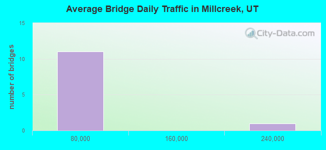
- 435,875Total average daily traffic
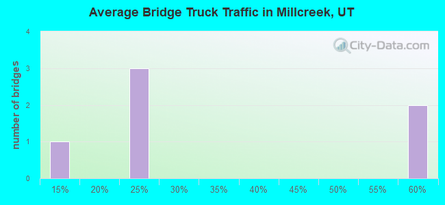
- 62,584Total average daily truck traffic
- National Bridge Inventory (NBI) Registered Bridges for Millcreek
- No street view available for this location
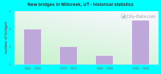
- New bridges - historical statistics
- 41960-1969
- 21970-1979
- 11980-1989
- 51990-1999
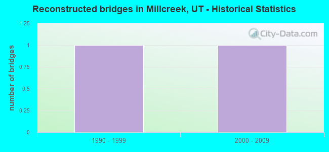
- Reconstructed bridges - Historical Statistics
- 11990-1999
- 12000-2009
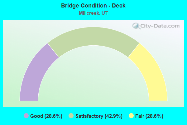
- Bridge Condition - Deck
- 28.6%Good
- 42.9%Satisfactory
- 28.6%Fair
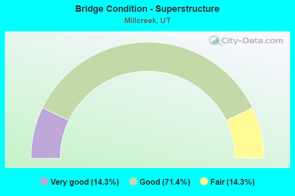
- Bridge Condition - Superstructure
- 14.3%Very good
- 71.4%Good
- 14.3%Fair
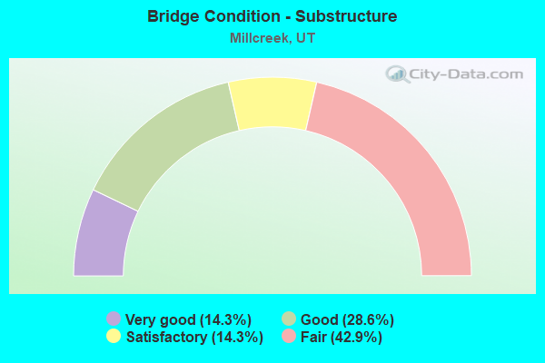
- Bridge Condition - Substructure
- 14.3%Very good
- 28.6%Good
- 14.3%Satisfactory
- 42.9%Fair
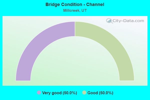
- Bridge Condition - Channel
- 50.0%Very good
- 50.0%Good
Find on map >> Show street view
Structure Number: 35020D, Location: 4735 S. 900 E., SL.CO. (Lat: 40.667194, Lng: -111.865006), Route carried "on" structure: County highway 2180, Year Built: 1998, Status: Open, Structure Length: 0.66m (2.17ft), Average Daily Traffic: 21,885 (year 2020), Average Future Daily Traffic: 27,356 (year 2040), Design Load: HS 20+Mod, Features Intersected: BIG COTTONWOOD CREEK, Facility Carried by Structure: 900 EAST STREET
Minimum Vertical Clearance: 30+ m (98+ ft), Kilometerpoint: 0.166, Lanes on structure: 4, Owner: Town or Township Highway Agency, Maintenance Responsibility: County Highway Agency, Approaching Roadway Width: 25.0m (82.0ft), Skew: 20 degrees, Material/Design: Concrete, Design/Construction: Frame, Number Of Spans In Main Unit: 1, Length of Maximum Span: 6.1m (20.0ft), Curb or Sidewalk Widths: Left: 1.8m (5.9ft), Right: 1.8m (5.9ft), Curb-To-Curb Width: 25.0m (82.0ft), Out-to-Out Width: 28.3m (92.8ft)
Condition: Deck: Good, Superstructure: Good, Substructure: Very good, Channel: Very good, Operating Rating: 63.8 metric tons, Method Used To Determine Operating Rating: Load and Resistance Factor Rating (LRFR) rating reported by rating factor(RF) method using HL-93 loadings, Inventory Rating: 43.7 metric tons, Method Used To Determine Inventory Rating: Load Factor (LF) rating reported by rating factor (RF) method using MS18 loading, Structural Evaluation: Better than present minimum criteria, Deck Geometry: Superior to present desirable criteria, Waterway Adequacy: Equal to present minimum criteria, Approach Roadway Alignment: Equal to present desirable criteria, Designated Inspection Frequency: Every 24 months, Inspection Date: December 2021, Deck Structure Type: Concrete Precast Panels, Wearing Surface/Protective System: Wearing Surface: Bituminous, Deck Protection: Epoxy Coated Reinforcing
Find on map >> Show street view
Structure Number: 35127F, Location: 300 W. 3900 S., SL.CO. (Lat: 40.686639, Lng: -111.900139), Route carried "on" structure: City street 2172, Year Built: 1965, Status: Open, Structure Length: 5.46m (17.91ft), Average Daily Traffic: 25,411 (year 2020), Average Future Daily Traffic: 31,764 (year 2040), Design Load: HS 20+Mod, Features Intersected: UNION PACIFIC RAILROAD, Facility Carried by Structure: 3900 SOUTH STREET
Minimum Vertical Clearance: 30+ m (98+ ft), Kilometerpoint: 16.292, Lanes on structure: 4, Lanes under structure: 2, Owner: City or Municipal Highway Agency, Approaching Roadway Width: 17.1m (56.1ft), Skew: 21 degrees, Material/Design: Prestressed concrete, Design/Construction: Stringer/Multi-beam, Number Of Spans In Main Unit: 3, Length of Maximum Span: 23.8m (78.1ft), Curb or Sidewalk Widths: Left: 0.6m (2.0ft), Right: 0.6m (2.0ft), Curb-To-Curb Width: 17.1m (56.1ft), Out-to-Out Width: 23.2m (76.1ft)
Condition: Deck: Fair, Superstructure: Fair, Substructure: Fair, Operating Rating: 68.7 metric tons, Method Used To Determine Operating Rating: Load and Resistance Factor Rating (LRFR) rating reported by rating factor(RF) method using HL-93 loadings, Inventory Rating: 58.6 metric tons, Method Used To Determine Inventory Rating: Load Factor (LF) rating reported by rating factor (RF) method using MS18 loading, Structural Evaluation: Somewhat better than minimum adequacy, Deck Geometry: Somewhat better than minimum adequacy, Underclear: Meets minimum limits, Approach Roadway Alignment: Equal to present minimum criteria, Designated Inspection Frequency: Every 24 months, Inspection Date: June 2020, Deck Structure Type: Concrete Cast-file-Place, Wearing Surface/Protective System: Wearing Surface: Bituminous
Find on map >> Show street view
Structure Number: 35204E, Location: 4720 South 1300 East (Lat: 40.667178, Lng: -111.854297), Route carried "on" structure: County highway 2076, Year Built: 1960, Status: Open, Structure Length: 0.96m (3.15ft), Average Daily Traffic: 12,428 (year 2020), Average Future Daily Traffic: 15,535 (year 2040), Design Load: HS 20+Mod, Features Intersected: BIG COTTON WOOD CREEK, Facility Carried by Structure: 1300 EAST STREET
Minimum Vertical Clearance: 30+ m (98+ ft), Kilometerpoint: 0.883, Lanes on structure: 2, Owner: Town or Township Highway Agency, Approaching Roadway Width: 18.3m (60.0ft), Skew: 1 degrees, Material/Design: Concrete, Design/Construction: Culvert, Number Of Spans In Main Unit: 2, Length of Maximum Span: 4.4m (14.4ft), Curb or Sidewalk Widths: Left: 1.0m (3.3ft), Right: 1.0m (3.3ft), Curb-To-Curb Width: 18.3m (60.0ft), Out-to-Out Width: 21.4m (70.2ft)
Condition: Channel: Good, Culverts: Satisfactory, Operating Rating: 32.4 metric tons, Method Used To Determine Operating Rating: Load and Resistance Factor Rating (LRFR) rating reported by rating factor(RF) method using HL-93 loadings, Inventory Rating: 16.2 metric tons, Method Used To Determine Inventory Rating: Load and Resistance Factor Rating (LRFR) rating reported by rating factor(RF) method using HL-93 loadings, Structural Evaluation: Meets minimum limits, Deck Geometry: Superior to present desirable criteria, Waterway Adequacy: Better than present minimum criteria, Approach Roadway Alignment: Equal to present desirable criteria, Designated Inspection Frequency: Every 24 months, Inspection Date: December 2021
Find on map >> Show street view
Structure Number: C 575, Location: ROCK QUARRY-PARLEYS CAN (Lat: 40.728814, Lng: -111.765164), Route carried "on" structure: ServiceInterstate 80, Year Built: 1973, Status: Open, Structure Length: 5.48m (17.98ft), Average Daily Traffic: 7,905 (year 2020), Truck Traffic: 58%, Average Future Daily Traffic: 9,881 (year 2040), Design Load: HS 20+Mod, Features Intersected: I-80 (SR-80) EBL & W, Facility Carried by Structure: INTCHG. X-ROAD.
Minimum Vertical Clearance: 30+ m (98+ ft), Kilometerpoint: 0.011, Lanes on structure: 2, Lanes under structure: 6, Owner: State Highway Agency, Approaching Roadway Width: 7.3m (24.0ft), Material/Design: Steel continuous, Design/Construction: Stringer/Multi-beam, Number Of Spans In Main Unit: 3, Length of Maximum Span: 38.4m (126.0ft), Curb-To-Curb Width: 7.3m (24.0ft), Out-to-Out Width: 8.5m (27.9ft)
Condition: Deck: Satisfactory, Superstructure: Good, Substructure: Satisfactory, Operating Rating: 34.3 metric tons, Method Used To Determine Operating Rating: Load and Resistance Factor Rating (LRFR) rating reported by rating factor(RF) method using HL-93 loadings, Inventory Rating: 27.2 metric tons, Method Used To Determine Inventory Rating: Load Factor (LF) rating reported by rating factor (RF) method using MS18 loading, Structural Evaluation: Equal to present minimum criteria, Deck Geometry: High priority of replacement, Underclear: Equal to present minimum criteria, Approach Roadway Alignment: Equal to present minimum criteria, Designated Inspection Frequency: Every 22 months, Inspection Date: June 2020, Deck Structure Type: Concrete Cast-file-Place, Wearing Surface/Protective System: Wearing Surface: Monolithic Concrete
Find on map >> Show street view
Structure Number: C 812, Location: 300 W.3900 SOUTH, SL.CO. (Lat: 40.686772, Lng: -111.903444), Route carried "on" structure: County highway 2172, Year Built: 1998, Status: Open, Structure Length: 8.08m (26.51ft), Average Daily Traffic: 25,411 (year 2020), Average Future Daily Traffic: 31,764 (year 2040), Design Load: HS 20+Mod, Features Intersected: I-15 (SR-15) NBL and SBL, Facility Carried by Structure: 3900 SOUTH STREET
Minimum Vertical Clearance: 30+ m (98+ ft), Kilometerpoint: 16.011, Lanes on structure: 4, Lanes under structure: 12, Owner: State Highway Agency, Approaching Roadway Width: 24.1m (79.1ft), Skew: 1 degrees, Material/Design: Steel continuous, Design/Construction: Stringer/Multi-beam, Number Of Spans In Main Unit: 2, Length of Maximum Span: 40.5m (132.9ft), Curb or Sidewalk Widths: Left: 2.0m (6.6ft), Right: 0.0m, Curb-To-Curb Width: 24.7m (81.0ft), Out-to-Out Width: 27.8m (91.2ft)
Condition: Deck: Satisfactory, Superstructure: Good, Substructure: Good, Operating Rating: 76.8 metric tons, Method Used To Determine Operating Rating: Load and Resistance Factor Rating (LRFR) rating reported by rating factor(RF) method using HL-93 loadings, Inventory Rating: 69.7 metric tons, Method Used To Determine Inventory Rating: Load Factor (LF) rating reported by rating factor (RF) method using MS18 loading, Structural Evaluation: Better than present minimum criteria, Deck Geometry: Superior to present desirable criteria, Underclear: Somewhat better than minimum adequacy, Approach Roadway Alignment: Equal to present desirable criteria, Designated Inspection Frequency: Every 24 months, Inspection Date: October 2020, Deck Structure Type: Concrete Cast-file-Place, Wearing Surface/Protective System: Wearing Surface: Monolithic Concrete, Deck Protection: Epoxy Coated Reinforcing
Find on map >> Show street view
Structure Number: 4C 424, Location: UPPER PARLEYS INTERCHANGE (Lat: 40.712436, Lng: -111.789553), Route carried "on" structure: Ramp Interstate 80, Year Built: 1964, Year Reconstructed: 2001, Status: Open, Structure Length: 6.71m (22.01ft), Average Daily Traffic: 7,905 (year 2020), Truck Traffic: 58%, Average Future Daily Traffic: 9,881 (year 2040), Design Load: HS 20+Mod, Features Intersected: I-80 (SR-80) AND WB
Minimum Vertical Clearance: 30+ m (98+ ft), Kilometerpoint: 0.295, Lanes on structure: 1, Lanes under structure: 4, Owner: State Highway Agency, Approaching Roadway Width: 6.7m (22.0ft), Skew: 6 degrees, Material/Design: Steel, Design/Construction: Stringer/Multi-beam, Number Of Spans In Main Unit: 3, Length of Maximum Span: 33.8m (110.9ft), Curb-To-Curb Width: 7.2m (23.6ft), Out-to-Out Width: 8.1m (26.6ft)
Condition: Deck: Good, Superstructure: Good, Substructure: Fair, Operating Rating: 53.8 metric tons, Method Used To Determine Operating Rating: Load and Resistance Factor Rating (LRFR) rating reported by rating factor(RF) method using HL-93 loadings, Inventory Rating: 42.8 metric tons, Method Used To Determine Inventory Rating: Load Factor (LF) rating reported by rating factor (RF) method using MS18 loading, Structural Evaluation: Somewhat better than minimum adequacy, Deck Geometry: Equal to present minimum criteria, Underclear: High priority of corrective action, Approach Roadway Alignment: Meets minimum limits, Designated Inspection Frequency: Every 26 months, Inspection Date: June 2020, Deck Structure Type: Concrete Cast-file-Place, Wearing Surface/Protective System: Wearing Surface: Bituminous, Membrane: Preformed Fabric, Deck Protection: Epoxy Coated Reinforcing
Find on map >> Show street view
Structure Number: 419010000009, Location: 3 MI UP MILL CREEK CANYON (Lat: 40.697703, Lng: -111.742683), Route carried "on" structure: Federal lands road 80208, Year Built: 1985, Year Reconstructed: 2000, Status: Open, Structure Length: 0.85m (2.79ft), Average Daily Traffic: 50 (year 0000), Average Future Daily Traffic: 75 (year 2042), Design Load: HS 20, Features Intersected: MILL CREEK
Minimum Vertical Clearance: 30+ m (98+ ft), Kilometerpoint: 0.032, Lanes on structure: 1, Owner: U.S. Forest Service, Approaching Roadway Width: 4.5m (14.8ft), Material/Design: Wood or Timber, Design/Construction: Stringer/Multi-beam, Number Of Spans In Main Unit: 1, Length of Maximum Span: 7.9m (25.9ft), Curb or Sidewalk Widths: Left: 0.2m (0.7ft), Right: 0.2m (0.7ft), Curb-To-Curb Width: 4.5m (14.8ft), Out-to-Out Width: 4.9m (16.1ft)
Condition: Deck: Satisfactory, Superstructure: Good, Substructure: Good, Channel: Good, Operating Rating: 33.0 metric tons, Method Used To Determine Operating Rating: Load and Resistance Factor Rating (LRFR) rating reported by rating factor(RF) method using HL-93 loadings, Inventory Rating: 25.3 metric tons, Method Used To Determine Inventory Rating: Load and Resistance Factor Rating (LRFR) rating reported by rating factor(RF) method using HL-93 loadings, Structural Evaluation: Equal to present minimum criteria, Deck Geometry: Equal to present minimum criteria, Waterway Adequacy: Superior to present desirable criteria, Approach Roadway Alignment: Somewhat better than minimum adequacy, Designated Inspection Frequency: Every 24 months, Inspection Date: October 2020, Deck Structure Type: Wood or Timber, Wearing Surface/Protective System: Wearing Surface: Bituminous
Find on map >> Show street view
Structure Number: 41901000001034, Location: 5 MILES UP MILLCREEK CAN (Lat: 40.699089, Lng: -111.722308), Route carried "on" structure: Federal lands road 80018, Year Built: 1990, Status: Open, Structure Length: 0.67m (2.20ft), Average Daily Traffic: 10 (year 1993), Average Future Daily Traffic: 15 (year 2042), Design Load: HS 20, Features Intersected: MILLCREEK CREEK
Minimum Vertical Clearance: 30+ m (98+ ft), Kilometerpoint: 0.009, Lanes on structure: 1, Owner: U.S. Forest Service, Approaching Roadway Width: 4.3m (14.1ft), Material/Design: Wood or Timber, Design/Construction: Slab, Number Of Spans In Main Unit: 1, Length of Maximum Span: 6.1m (20.0ft), Curb or Sidewalk Widths: Left: 0.2m (0.7ft), Right: 0.2m (0.7ft), Curb-To-Curb Width: 4.3m (14.1ft), Out-to-Out Width: 4.9m (16.1ft)
Condition: Deck: Fair, Superstructure: Very good, Substructure: Fair, Channel: Very good, Operating Rating: 42.1 metric tons, Method Used To Determine Operating Rating: Load and Resistance Factor Rating (LRFR) rating reported by rating factor(RF) method using HL-93 loadings, Inventory Rating: 32.4 metric tons, Method Used To Determine Inventory Rating: Load and Resistance Factor Rating (LRFR) rating reported by rating factor(RF) method using HL-93 loadings, Structural Evaluation: Somewhat better than minimum adequacy, Deck Geometry: Equal to present minimum criteria, Waterway Adequacy: Superior to present desirable criteria, Approach Roadway Alignment: Better than present minimum criteria, Designated Inspection Frequency: Every 24 months, Inspection Date: October 2020, Deck Structure Type: Wood or Timber, Wearing Surface/Protective System: Wearing Surface: Bituminous, Membrane: Preformed Fabric, Deck Protection: Internally Sealed
Find on map >> Show street view
Structure Number: C 575, Location: ROCK QUARRY-PARLEYS CAN (Lat: 40.728814, Lng: -111.765164), Route carried "under" structure: Interstate 80, Year Built: 1973, Structure Length: 0. m, Average Daily Traffic: 52,967 (year 2020), Truck Traffic: 24%, Features Intersected: I-80 (SR-80) EBL & W, Facility Carried by Structure: INTCHG. X-ROAD.
Minimum Vertical Clearance: 5.29m (17.36ft), Kilometerpoint: 209.855, Lanes on structure: 2, Lanes under structure: 6, Material/Design: Steel continuous, Design/Construction: Stringer/Multi-beam, Length of Maximum Span: 38.4m (126.0ft)
Find on map >> Show street view
Structure Number: C 812, Location: 300 W.3900 SOUTH, SL.CO. (Lat: 40.686772, Lng: -111.903444), Route carried "under" structure: Interstate 15, Year Built: 1998, Structure Length: 0. m, Average Daily Traffic: 209,401 (year 2020), Truck Traffic: 12%, Features Intersected: I-15 (SR-15) NBL and SBL, Facility Carried by Structure: 3900 SOUTH STREET
Minimum Vertical Clearance: 5.13m (16.83ft), Kilometerpoint: 486.875, Lanes on structure: 4, Lanes under structure: 12, Material/Design: Steel continuous, Design/Construction: Stringer/Multi-beam, Length of Maximum Span: 40.5m (132.9ft)
Find on map >> Show street view
Structure Number: C 89, Location: Mouth of Parleys Canyon (Lat: 40.712428, Lng: -111.802464), Route carried "under" structure: Interstate 80, Year Built: 1999, Structure Length: 0. m, Average Daily Traffic: 37,353 (year 2020), Truck Traffic: 21%, Features Intersected: I-80 (SR-80) EB and WB, Facility Carried by Structure: Pedestrian Overpas
Minimum Vertical Clearance: 5.54m (18.18ft), Kilometerpoint: 205.867, Lanes under structure: 4, Material/Design: Steel, Design/Construction: Box Beam or Girders - Single/Spread, Length of Maximum Span: 45.0m (147.6ft)
Find on map >> Show street view
Structure Number: 4C 424, Location: UPPER PARLEYS INTERCHANGE (Lat: 40.712436, Lng: -111.789553), Route carried "under" structure: Interstate 80, Year Built: 1964, Structure Length: 0. m, Average Daily Traffic: 35,149 (year 2020), Truck Traffic: 22%, Features Intersected: I-80 (SR-80) AND WB
Minimum Vertical Clearance: 5.26m (17.26ft), Kilometerpoint: 207.020, Lanes on structure: 1, Lanes under structure: 4, Material/Design: Steel, Design/Construction: Stringer/Multi-beam, Length of Maximum Span: 33.8m (110.9ft)