Bridge Statistics for Millersburg, Indiana (IN)
Condition, Traffic, Stress, Structural Evaluation, Project Costs
- National Bridge Inventory (NBI) Statistics
- 14Number of bridges
- 108ft / 32.5mTotal length
- $2,288,000Total costs
- 20,475Total average daily traffic
- 3,422Total average daily truck traffic
- 26,449Total future (year 2033) average daily traffic
- National Bridge Inventory (NBI) Registered Bridges for Millersburg
- No street view available for this location
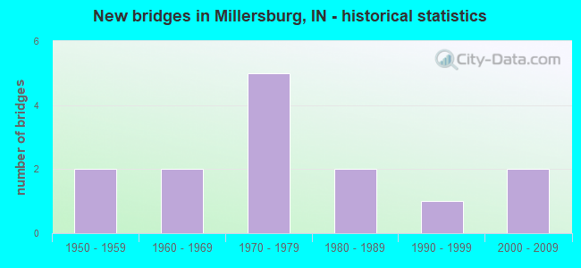
- New bridges - historical statistics
- 21950-1959
- 21960-1969
- 51970-1979
- 21980-1989
- 11990-1999
- 22000-2009

- Reconstructed bridges - Historical Statistics
- 11980-1989
- 11990-1999
- 02000-2009
- 12010-2019


- Bridge Condition - Deck
- 9.1%Very good
- 18.2%Good
- 27.3%Satisfactory
- 36.4%Fair
- 9.1%Poor

- Bridge Condition - Superstructure
- 18.2%Very good
- 9.1%Good
- 27.3%Satisfactory
- 36.4%Fair
- 9.1%Poor

- Bridge Condition - Substructure
- 9.1%Very good
- 54.5%Good
- 18.2%Satisfactory
- 18.2%Fair

- Bridge Condition - Channel
- 7.7%Very good
- 23.1%Good
- 38.5%Satisfactory
- 30.8%Fair

- Bridge Condition - Culverts
- 33.3%Very good
- 33.3%Satisfactory
- 33.3%Fair
Find on map >> Show street view
Structure Number: 1096, Location: 01.18 N SR 13 (Lat: 41.481419, Lng: -85.706581), Route carried "on" structure: US 33, Year Built: 1953, Year Reconstructed: 1999, Status: Open, Structure Length: 1.89m (6.20ft), Average Daily Traffic: 6,014 (year 2020), Truck Traffic: 11%, Average Future Daily Traffic: 6,162 (year 2034), Design Load: HS 20, Features Intersected: DRY RUN
Minimum Vertical Clearance: 30+ m (98+ ft), Kilometerpoint: 7.226, Lanes on structure: 2, Base Highway Network: Yes (, Subroute: 1), Owner: State Highway Agency, Approaching Roadway Width: 13.1m (43.0ft), Skew: 4 degrees, Material/Design: Concrete continuous, Design/Construction: Slab, Number Of Spans In Main Unit: 3, Length of Maximum Span: 7.3m (24.0ft), Curb-To-Curb Width: 13.2m (43.3ft), Out-to-Out Width: 14.1m (46.3ft)
Condition: Deck: Satisfactory, Superstructure: Satisfactory, Substructure: Very good, Channel: Good, Operating Rating: 57.7 metric tons, Method Used To Determine Operating Rating: Load and Resistance Factor Rating (LRFR) rating reported by rating factor(RF) method using HL-93 loadings, Inventory Rating: 44.4 metric tons, Method Used To Determine Inventory Rating: Load and Resistance Factor Rating (LRFR) rating reported by rating factor(RF) method using HL-93 loadings, Structural Evaluation: Equal to present minimum criteria, Deck Geometry: Somewhat better than minimum adequacy, Waterway Adequacy: Equal to present desirable criteria, Approach Roadway Alignment: Equal to present desirable criteria, Designated Inspection Frequency: Every 24 months, Inspection Date: August 2021, Deck Structure Type: Concrete Cast-file-Place, Wearing Surface/Protective System: Wearing Surface: Monolithic Concrete, Deck Protection: Epoxy Coated Reinforcing
Find on map >> Show street view
Structure Number: 76526, Location: 04.09 N US 33 (Lat: 41.507739, Lng: -85.693231), Route carried "on" structure: State highway 13, Year Built: 2009, Status: Open, Structure Length: 5.29m (17.36ft), Average Daily Traffic: 4,007 (year 2019), Truck Traffic: 13%, Average Future Daily Traffic: 2,425 (year 2033), Design Load: HS 25 or greater, Features Intersected: ELKHART RIVER
Minimum Vertical Clearance: 30+ m (98+ ft), Kilometerpoint: 14.355, Lanes on structure: 2, Owner: State Highway Agency, Approaching Roadway Width: 12.2m (40.0ft), Skew: 4 degrees, Material/Design: Prestressed concrete continuous, Design/Construction: Stringer/Multi-beam, Number Of Spans In Main Unit: 3, Length of Maximum Span: 18.3m (60.0ft), Curb-To-Curb Width: 11.4m (37.4ft), Out-to-Out Width: 12.3m (40.4ft)
Condition: Deck: Very good, Superstructure: Very good, Substructure: Good, Channel: Very good, Operating Rating: 62.2 metric tons, Method Used To Determine Operating Rating: Load and Resistance Factor Rating (LRFR) rating reported by rating factor(RF) method using HL-93 loadings, Inventory Rating: 47.3 metric tons, Method Used To Determine Inventory Rating: Load and Resistance Factor Rating (LRFR) rating reported by rating factor(RF) method using HL-93 loadings, Structural Evaluation: Better than present minimum criteria, Deck Geometry: Somewhat better than minimum adequacy, Waterway Adequacy: Equal to present desirable criteria, Approach Roadway Alignment: Equal to present desirable criteria, Designated Inspection Frequency: Every 24 months, Inspection Date: August 2020, Deck Structure Type: Concrete Cast-file-Place, Wearing Surface/Protective System: Wearing Surface: Monolithic Concrete, Deck Protection: Epoxy Coated Reinforcing
Find on map >> Show street view
Structure Number: 200005, Location: 00.10 E SCIPIO ROAD (Lat: 41.184919, Lng: -84.811731), Route carried "on" structure: County highway 336, Year Built: 1997, Status: Open, Structure Length: 3.28m (10.76ft), Average Daily Traffic: 625 (year 2018), Truck Traffic: 5%, Average Future Daily Traffic: 933 (year 2038), Design Load: HS 20, Features Intersected: HAMM INTERCEPTOR DRAIN, Facility Carried by Structure: NOTESTINE RD
Minimum Vertical Clearance: 30+ m (98+ ft), Kilometerpoint: 0.000, Lanes on structure: 2, Owner: County Highway Agency, Approaching Roadway Width: 5.8m (19.0ft), Material/Design: Concrete continuous, Design/Construction: Slab, Number Of Spans In Main Unit: 3, Length of Maximum Span: 12.0m (39.4ft), Curb-To-Curb Width: 9.8m (32.2ft), Out-to-Out Width: 10.7m (35.1ft)
Condition: Deck: Fair, Superstructure: Fair, Substructure: Good, Channel: Good, Operating Rating: 70.6 metric tons, Method Used To Determine Operating Rating: Load Factor (LF), Inventory Rating: 42.2 metric tons, Method Used To Determine Inventory Rating: Load Factor (LF), Structural Evaluation: Somewhat better than minimum adequacy, Deck Geometry: Equal to present minimum criteria, Waterway Adequacy: Better than present minimum criteria, Approach Roadway Alignment: Equal to present desirable criteria, Designated Inspection Frequency: Every 24 months, Inspection Date: May 2020, Deck Structure Type: Concrete Cast-file-Place, Wearing Surface/Protective System: Wearing Surface: Monolithic Concrete, Deck Protection: Epoxy Coated Reinforcing
Find on map >> Show street view
Structure Number: 2000051, Location: 00.20 W OF SR 13 (Lat: 41.523189, Lng: -85.699553), Route carried "on" structure: City street 32, Year Built: 1976, Status: Open, Structure Length: 2.23m (7.32ft), Average Daily Traffic: 2,477 (year 2018), Truck Traffic: 15%, Average Future Daily Traffic: 4,266 (year 2038), Features Intersected: CONRAIL RR, Facility Carried by Structure: CR 42
Minimum Vertical Clearance: 7.32m (24.02ft), Kilometerpoint: 0.000, Lanes on structure: 2, Owner: County Highway Agency, Approaching Roadway Width: 6.7m (22.0ft), Skew: 3 degrees, Material/Design: Prestressed concrete, Design/Construction: Box Beam or Girders - Multiple, Number Of Spans In Main Unit: 1, Length of Maximum Span: 20.1m (65.9ft), Curb or Sidewalk Widths: Left: 1.2m (3.9ft), Right: 0.2m (0.7ft), Curb-To-Curb Width: 8.5m (27.9ft), Out-to-Out Width: 10.1m (33.1ft)
Condition: Deck: Fair, Superstructure: Satisfactory, Substructure: Satisfactory, Operating Rating: 52.1 metric tons, Method Used To Determine Operating Rating: Load and Resistance Factor (LRFR), Inventory Rating: 35.7 metric tons, Method Used To Determine Inventory Rating: Load and Resistance Factor (LRFR), Structural Evaluation: Equal to present minimum criteria, Deck Geometry: Meets minimum limits, Underclear: Better than present minimum criteria, Approach Roadway Alignment: Equal to present desirable criteria, Designated Inspection Frequency: Every 24 months, Inspection Date: August 2020, Deck Structure Type: Concrete Cast-file-Place, Wearing Surface/Protective System: Wearing Surface: Latex Concrete
Find on map >> Show street view
Structure Number: 2000052, Location: 00.40 N OF CR 40 (Lat: 41.541911, Lng: -85.655122), Route carried "on" structure: Alternate County highway , Year Built: 1979, Status: Open, Structure Length: 0.76m (2.49ft), Average Daily Traffic: 464 (year 2018), Truck Traffic: 19%, Average Future Daily Traffic: 799 (year 2038), Features Intersected: MARTIN FOX DITCH, Facility Carried by Structure: E COUNTY LINE RD
Minimum Vertical Clearance: 30+ m (98+ ft), Kilometerpoint: 0.000, Lanes on structure: 2, Owner: County Highway Agency, Approaching Roadway Width: 6.4m (21.0ft), Skew: 4 degrees, Material/Design: Steel, Design/Construction: Culvert, Number Of Spans In Main Unit: 2, Length of Maximum Span: 3.5m (11.5ft), Curb-To-Curb Width: 6.4m (21.0ft), Out-to-Out Width: 6.4m (21.0ft)
Condition: Channel: Fair, Culverts: Fair, Operating Rating: 90.2 metric tons, Method Used To Determine Operating Rating: Load and Resistance Factor (LRFR), Inventory Rating: 71.6 metric tons, Method Used To Determine Inventory Rating: Load and Resistance Factor (LRFR), Structural Evaluation: Somewhat better than minimum adequacy, Deck Geometry: High priority of corrective action, Waterway Adequacy: Better than present minimum criteria, Approach Roadway Alignment: Equal to present desirable criteria, Length Of Structure Improvement: 1.40m (4.59ft), Designated Inspection Frequency: Every 24 months, Inspection Date: August 2020, Bridge Improvement Cost: $197,000, Roadway Improvement Cost: $190,000, Total Project Cost: $489,000 ( Estimate for 2020)
Find on map >> Show street view
Structure Number: 2000053, Location: 00.50 E OF CR 43 (Lat: 41.537881, Lng: -85.663681), Route carried "on" structure: Alternate County highway 36, Year Built: 1967, Year Reconstructed: 2015, Status: Open, Structure Length: 1.88m (6.17ft), Average Daily Traffic: 1,235 (year 2020), Truck Traffic: 29%, Average Future Daily Traffic: 2,127 (year 2040), Design Load: HL 93, Features Intersected: STONY CREEK, Facility Carried by Structure: CR 40
Minimum Vertical Clearance: 30+ m (98+ ft), Kilometerpoint: 0.000, Lanes on structure: 2, Owner: County Highway Agency, Approaching Roadway Width: 7.9m (25.9ft), Material/Design: Prestressed concrete, Design/Construction: Box Beam or Girders - Multiple, Number Of Spans In Main Unit: 1, Length of Maximum Span: 17.6m (57.7ft), Curb-To-Curb Width: 8.1m (26.6ft), Out-to-Out Width: 8.6m (28.2ft)
Condition: Deck: Good, Superstructure: Very good, Substructure: Good, Channel: Good, Operating Rating: 56.4 metric tons, Method Used To Determine Operating Rating: Load and Resistance Factor (LRFR), Inventory Rating: 45.4 metric tons, Method Used To Determine Inventory Rating: Load and Resistance Factor (LRFR), Structural Evaluation: Better than present minimum criteria, Deck Geometry: Meets minimum limits, Waterway Adequacy: Equal to present desirable criteria, Approach Roadway Alignment: Equal to present desirable criteria, Designated Inspection Frequency: Every 24 months, Inspection Date: August 2020, Deck Structure Type: Concrete Cast-file-Place, Wearing Surface/Protective System: Wearing Surface: Monolithic Concrete, Deck Protection: Epoxy Coated Reinforcing
Find on map >> Show street view
Structure Number: 2000054, Location: 00.30 E OF CR 43 (Lat: 41.552431, Lng: -85.670456), Route carried "on" structure: Alternate County highway 320, Year Built: 1960, Status: Open, Structure Length: 1.22m (4.00ft), Average Daily Traffic: 2,750 (year 2020), Truck Traffic: 29%, Average Future Daily Traffic: 4,737 (year 2040), Design Load: H 20, Features Intersected: MCALLISTER DITCH, Facility Carried by Structure: CR 38
Minimum Vertical Clearance: 30+ m (98+ ft), Kilometerpoint: 0.000, Lanes on structure: 2, Owner: County Highway Agency, Approaching Roadway Width: 6.7m (22.0ft), Material/Design: Prestressed concrete, Design/Construction: Box Beam or Girders - Multiple, Number Of Spans In Main Unit: 1, Length of Maximum Span: 11.0m (36.1ft), Curb or Sidewalk Widths: Left: 0.3m (1.0ft), Right: 0.3m (1.0ft), Curb-To-Curb Width: 7.8m (25.6ft), Out-to-Out Width: 8.4m (27.6ft)
Condition: Deck: Fair, Superstructure: Fair, Substructure: Fair, Channel: Fair, Operating Rating: 41.4 metric tons, Method Used To Determine Operating Rating: Load and Resistance Factor (LRFR), Inventory Rating: 28.4 metric tons, Method Used To Determine Inventory Rating: Load and Resistance Factor (LRFR), Structural Evaluation: Somewhat better than minimum adequacy, Deck Geometry: High priority of replacement, Waterway Adequacy: Somewhat better than minimum adequacy, Approach Roadway Alignment: Equal to present desirable criteria, Designated Inspection Frequency: Every 24 months, Inspection Date: August 2020, Deck Structure Type: Concrete Precast Panels, Wearing Surface/Protective System: Wearing Surface: Bituminous
Find on map >> Show street view
Structure Number: 2000055, Location: 00.20 N OF CR 38 (Lat: 41.554739, Lng: -85.674294), Route carried "on" structure: Alternate County highway 349, Year Built: 1978, Status: Open, Structure Length: 0.63m (2.07ft), Average Daily Traffic: 254 (year 2020), Truck Traffic: 23%, Average Future Daily Traffic: 437 (year 2040), Features Intersected: MCALLISTER DITCH, Facility Carried by Structure: CR 43
Minimum Vertical Clearance: 30+ m (98+ ft), Kilometerpoint: 0.000, Lanes on structure: 2, Owner: County Highway Agency, Approaching Roadway Width: 5.8m (19.0ft), Material/Design: Steel, Design/Construction: Culvert, Number Of Spans In Main Unit: 2, Length of Maximum Span: 2.9m (9.5ft), Curb-To-Curb Width: 5.8m (19.0ft), Out-to-Out Width: 5.8m (19.0ft)
Condition: Channel: Fair, Culverts: Satisfactory, Operating Rating: 79.3 metric tons, Method Used To Determine Operating Rating: Load and Resistance Factor (LRFR), Inventory Rating: 62.9 metric tons, Method Used To Determine Inventory Rating: Load and Resistance Factor (LRFR), Structural Evaluation: Equal to present minimum criteria, Deck Geometry: High priority of corrective action, Waterway Adequacy: Somewhat better than minimum adequacy, Approach Roadway Alignment: Equal to present desirable criteria, Designated Inspection Frequency: Every 24 months, Inspection Date: August 2020
Find on map >> Show street view
Structure Number: 2000056, Location: 00.20 N OF CR 42 (Lat: 41.525789, Lng: -85.674050), Route carried "on" structure: Alternate County highway 349, Year Built: 1970, Status: Posted for load, Structure Length: 1.52m (4.99ft), Average Daily Traffic: 218 (year 2020), Truck Traffic: 21%, Average Future Daily Traffic: 375 (year 2040), Design Load: H 20, Features Intersected: STONY CREEK, Facility Carried by Structure: CR 43
Minimum Vertical Clearance: 30+ m (98+ ft), Kilometerpoint: 0.000, Lanes on structure: 2, Owner: County Highway Agency, Approaching Roadway Width: 5.8m (19.0ft), Material/Design: Prestressed concrete, Design/Construction: Box Beam or Girders - Multiple, Number Of Spans In Main Unit: 1, Length of Maximum Span: 14.0m (45.9ft), Curb-To-Curb Width: 8.4m (27.6ft), Out-to-Out Width: 8.6m (28.2ft)
Condition: Deck: Poor, Superstructure: Poor, Substructure: Good, Channel: Satisfactory, Operating Rating: 23.3 metric tons, Method Used To Determine Operating Rating: Load and Resistance Factor Rating (LRFR) rating reported by rating factor(RF) method using HL-93 loadings, Inventory Rating: 18.1 metric tons, Method Used To Determine Inventory Rating: Load and Resistance Factor Rating (LRFR) rating reported by rating factor(RF) method using HL-93 loadings, Structural Evaluation: Meets minimum limits, Deck Geometry: Somewhat better than minimum adequacy, Waterway Adequacy: Equal to present desirable criteria, Approach Roadway Alignment: Equal to present desirable criteria, Bridge Posting: Required (Relationship of Operating Rating to Maximum Legal Load: 10.0 - 19.9% below), Length Of Structure Improvement: 1.52m (4.99ft), Designated Inspection Frequency: Every 12 months, Inspection Date: August 2021, Bridge Improvement Cost: $118,000, Roadway Improvement Cost: $190,000, Total Project Cost: $373,000 ( Estimate for 2020), Deck Structure Type: Concrete Precast Panels, Wearing Surface/Protective System: Wearing Surface: Bituminous
Find on map >> Show street view
Structure Number: 2000057, Location: 00.40 W OF CR 43 (Lat: 41.523161, Lng: -85.681708), Route carried "on" structure: County highway 904, Year Built: 1957, Year Reconstructed: 1980, Status: Posted for load, Structure Length: 1.52m (4.99ft), Average Daily Traffic: 1,374 (year 2019), Truck Traffic: 20%, Average Future Daily Traffic: 2,367 (year 2039), Design Load: H 15, Features Intersected: STONY CREEK, Facility Carried by Structure: CR 42
Minimum Vertical Clearance: 30+ m (98+ ft), Kilometerpoint: 0.000, Lanes on structure: 2, Owner: County Highway Agency, Approaching Roadway Width: 6.4m (21.0ft), Material/Design: Prestressed concrete, Design/Construction: Box Beam or Girders - Multiple, Number Of Spans In Main Unit: 1, Length of Maximum Span: 14.3m (46.9ft), Curb or Sidewalk Widths: Left: 0.3m (1.0ft), Right: 0.3m (1.0ft), Curb-To-Curb Width: 7.7m (25.3ft), Out-to-Out Width: 8.3m (27.2ft)
Condition: Deck: Satisfactory, Superstructure: Fair, Substructure: Satisfactory, Channel: Satisfactory, Operating Rating: 25.3 metric tons, Method Used To Determine Operating Rating: Load and Resistance Factor (LRFR), Inventory Rating: 16.9 metric tons, Method Used To Determine Inventory Rating: Load and Resistance Factor (LRFR), Structural Evaluation: Meets minimum limits, Deck Geometry: Meets minimum limits, Waterway Adequacy: Equal to present desirable criteria, Approach Roadway Alignment: Equal to present desirable criteria, Bridge Posting: Required (Relationship of Operating Rating to Maximum Legal Load: 20.0 - 29.9% below), Length Of Structure Improvement: 1.52m (4.99ft), Designated Inspection Frequency: Every 24 months, Inspection Date: August 2020, Bridge Improvement Cost: $134,000, Roadway Improvement Cost: $190,000, Total Project Cost: $393,000 ( Estimate for 2020), Deck Structure Type: Concrete Cast-file-Place, Wearing Surface/Protective System: Wearing Surface: Monolithic Concrete
Find on map >> Show street view
Structure Number: 200014, Location: 00.40 W OF US 33 (Lat: 41.488050, Lng: -85.725039), Route carried "on" structure: Alternate County highway 16, Year Built: 2007, Status: Open, Structure Length: 1.42m (4.66ft), Average Daily Traffic: 211 (year 2018), Truck Traffic: 14%, Average Future Daily Traffic: 363 (year 2038), Design Load: HS 25 or greater, Features Intersected: DRY RUN DITCH, Facility Carried by Structure: CR 146
Minimum Vertical Clearance: 30+ m (98+ ft), Kilometerpoint: 0.000, Lanes on structure: 2, Owner: County Highway Agency, Approaching Roadway Width: 4.9m (16.1ft), Skew: 5 degrees, Material/Design: Concrete, Design/Construction: Culvert, Number Of Spans In Main Unit: 1, Length of Maximum Span: 13.4m (44.0ft), Curb-To-Curb Width: 4.9m (16.1ft), Out-to-Out Width: 4.9m (16.1ft)
Condition: Channel: Satisfactory, Culverts: Very good, Operating Rating: 32.7 metric tons, Method Used To Determine Operating Rating: Field evaluation and documented engineering judgment, Inventory Rating: 32.7 metric tons, Method Used To Determine Inventory Rating: Field evaluation and documented engineering judgment, Structural Evaluation: Equal to present desirable criteria, Deck Geometry: High priority of replacement, Waterway Adequacy: Equal to present desirable criteria, Approach Roadway Alignment: Equal to present minimum criteria, Designated Inspection Frequency: Every 24 months, Inspection Date: August 2020
Find on map >> Show street view
Structure Number: 2000142, Location: 00.20 S OF CR 44 (Lat: 41.506339, Lng: -85.713264), Route carried "on" structure: Alternate County highway 299, Year Built: 1986, Status: Open, Structure Length: 6.28m (20.60ft), Average Daily Traffic: 480 (year 2020), Truck Traffic: 22%, Average Future Daily Traffic: 827 (year 2040), Design Load: HS 20, Features Intersected: ELKHART RIVER, Facility Carried by Structure: CR 37
Minimum Vertical Clearance: 30+ m (98+ ft), Kilometerpoint: 0.000, Lanes on structure: 2, Owner: County Highway Agency, Approaching Roadway Width: 6.7m (22.0ft), Skew: 1 degrees, Material/Design: Wood or Timber, Design/Construction: Slab, Number Of Spans In Main Unit: 7, Length of Maximum Span: 9.8m (32.2ft), Curb or Sidewalk Widths: Left: 0.2m (0.7ft), Right: 0.2m (0.7ft), Curb-To-Curb Width: 9.0m (29.5ft), Out-to-Out Width: 9.4m (30.8ft)
Condition: Deck: Good, Superstructure: Good, Substructure: Good, Channel: Satisfactory, Operating Rating: 48.7 metric tons, Method Used To Determine Operating Rating: Load and Resistance Factor (LRFR), Inventory Rating: 36.1 metric tons, Method Used To Determine Inventory Rating: Load and Resistance Factor (LRFR), Structural Evaluation: Better than present minimum criteria, Deck Geometry: Somewhat better than minimum adequacy, Waterway Adequacy: Equal to present desirable criteria, Approach Roadway Alignment: Equal to present desirable criteria, Designated Inspection Frequency: Every 24 months, Inspection Date: August 2020, Deck Structure Type: Wood or Timber, Wearing Surface/Protective System: Wearing Surface: Bituminous
Find on map >> Show street view
Structure Number: 2000145, Location: 00.30 E OF SR 13 (Lat: 41.510931, Lng: -85.687903), Route carried "on" structure: Alternate County highway 69, Year Built: 1977, Status: Open, Structure Length: 1.72m (5.64ft), Average Daily Traffic: 160 (year 2020), Truck Traffic: 19%, Average Future Daily Traffic: 276 (year 2040), Design Load: HS 20, Features Intersected: STONY CREEK, Facility Carried by Structure: CR 44
Minimum Vertical Clearance: 30+ m (98+ ft), Kilometerpoint: 0.000, Lanes on structure: 2, Owner: County Highway Agency, Approaching Roadway Width: 7.3m (24.0ft), Skew: 3 degrees, Material/Design: Prestressed concrete, Design/Construction: Box Beam or Girders - Multiple, Number Of Spans In Main Unit: 1, Length of Maximum Span: 15.8m (51.8ft), Curb-To-Curb Width: 8.8m (28.9ft), Out-to-Out Width: 9.0m (29.5ft)
Condition: Deck: Fair, Superstructure: Fair, Substructure: Fair, Channel: Fair, Operating Rating: 43.5 metric tons, Method Used To Determine Operating Rating: Load and Resistance Factor (LRFR), Inventory Rating: 31.5 metric tons, Method Used To Determine Inventory Rating: Load and Resistance Factor (LRFR), Structural Evaluation: Somewhat better than minimum adequacy, Deck Geometry: Equal to present minimum criteria, Waterway Adequacy: Equal to present desirable criteria, Approach Roadway Alignment: High priority of corrective action, Length Of Structure Improvement: 2.41m (7.91ft), Designated Inspection Frequency: Every 24 months, Inspection Date: August 2020, Bridge Improvement Cost: $337,000, Roadway Improvement Cost: $481,000, Total Project Cost: $1,033,000 ( Estimate for 2020), Deck Structure Type: Concrete Precast Panels, Wearing Surface/Protective System: Wearing Surface: Bituminous
Find on map >> Show street view
Structure Number: 2000146, Location: 00.20 S OF CR 44 (Lat: 41.505650, Lng: -85.673408), Route carried "on" structure: Alternate County highway 69, Year Built: 1981, Status: Open, Structure Length: 2.90m (9.51ft), Average Daily Traffic: 206 (year 2019), Truck Traffic: 27%, Average Future Daily Traffic: 355 (year 2039), Design Load: HS 20, Features Intersected: ELKHART RIVER, Facility Carried by Structure: CR 43
Minimum Vertical Clearance: 30+ m (98+ ft), Kilometerpoint: 0.000, Lanes on structure: 2, Owner: County Highway Agency, Approaching Roadway Width: 6.4m (21.0ft), Skew: 3 degrees, Material/Design: Wood or Timber, Design/Construction: Slab, Number Of Spans In Main Unit: 3, Length of Maximum Span: 9.4m (30.8ft), Curb or Sidewalk Widths: Left: 0.2m (0.7ft), Right: 0.2m (0.7ft), Curb-To-Curb Width: 8.5m (27.9ft), Out-to-Out Width: 8.9m (29.2ft)
Condition: Deck: Satisfactory, Superstructure: Satisfactory, Substructure: Good, Channel: Satisfactory, Operating Rating: 64.1 metric tons, Method Used To Determine Operating Rating: Load and Resistance Factor (LRFR), Inventory Rating: 47.6 metric tons, Method Used To Determine Inventory Rating: Load and Resistance Factor (LRFR), Structural Evaluation: Equal to present minimum criteria, Deck Geometry: Equal to present minimum criteria, Waterway Adequacy: Equal to present desirable criteria, Approach Roadway Alignment: Equal to present minimum criteria, Designated Inspection Frequency: Every 24 months, Inspection Date: August 2020, Deck Structure Type: Wood or Timber, Wearing Surface/Protective System: Wearing Surface: Bituminous