Bridge Statistics for Millport, Alabama (AL)
Condition, Traffic, Stress, Structural Evaluation, Project Costs
- National Bridge Inventory (NBI) Statistics
- 11Number of bridges
- 85ft / 26.0mTotal length
- $8,234,000Total costs
- 18,150Total average daily traffic
- 2,453Total average daily truck traffic
- 23,348Total future (year 2032) average daily traffic
- National Bridge Inventory (NBI) Registered Bridges for Millport
- No street view available for this location
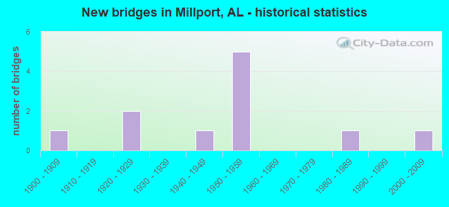
- New bridges - historical statistics
- 11900-1909
- 21920-1929
- 11940-1949
- 51950-1959
- 11980-1989
- 12000-2009

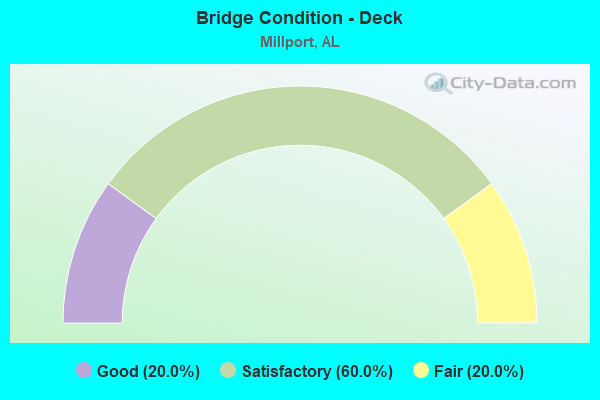
- Bridge Condition - Deck
- 20.0%Good
- 60.0%Satisfactory
- 20.0%Fair

- Bridge Condition - Superstructure
- 40.0%Good
- 40.0%Satisfactory
- 20.0%Poor
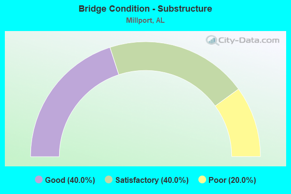
- Bridge Condition - Substructure
- 40.0%Good
- 40.0%Satisfactory
- 20.0%Poor
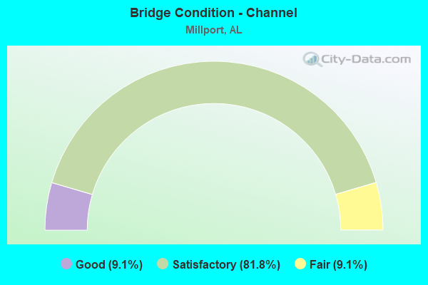
- Bridge Condition - Channel
- 9.1%Good
- 81.8%Satisfactory
- 9.1%Fair

- Bridge Condition - Culverts
- 16.7%Good
- 83.3%Satisfactory
Find on map >> Show street view
Structure Number: 5, Location: 0.5 MI E SR#17 (Lat: 33.565892, Lng: -88.073828), Route carried "on" structure: City street , Year Built: 1900, Status: Posted for load, Structure Length: 1.55m (5.09ft), Average Daily Traffic: 15 (year 2007), Average Future Daily Traffic: 59 (year 2032), Design Load: H 10, Features Intersected: Driver Creek, Facility Carried by Structure: RAILROAD STREET
Minimum Vertical Clearance: 30+ m (98+ ft), Kilometerpoint: 0.499, Lanes on structure: 1, Owner: City or Municipal Highway Agency, Approaching Roadway Width: 3.0m (9.8ft), Material/Design: Steel continuous, Design/Construction: Truss - Thru, Number Of Spans In Main Unit: 2, Length of Maximum Span: 7.9m (25.9ft), Curb-To-Curb Width: 4.4m (14.4ft), Out-to-Out Width: 4.8m (15.7ft)
Condition: Deck: Fair, Superstructure: Poor, Substructure: Poor, Channel: Fair, Operating Rating: 4.5 metric tons, Method Used To Determine Operating Rating: Load Factor (LF), Inventory Rating: 2.7 metric tons, Method Used To Determine Inventory Rating: Load Factor (LF), Structural Evaluation: High priority of replacement, Deck Geometry: Equal to present minimum criteria, Waterway Adequacy: Meets minimum limits, Approach Roadway Alignment: Somewhat better than minimum adequacy, Bridge Posting: Required (Relationship of Operating Rating to Maximum Legal Load: > 39.9% below), Length Of Structure Improvement: 2.23m (7.32ft), Designated Inspection Frequency: Every 24 months, Critical Feature Inspection Frequency: Every 12 months, Other Special Inspection Frequency: Every 12 months, Inspection Date: June 2020, Critical Feature Inspection Date: June 2021, Other Special Inspection Date: June 2021, Bridge Improvement Cost: $230,000, Roadway Improvement Cost: $23,000, Total Project Cost: $253,000 ( Estimate for 2022), Deck Structure Type: Wood or Timber, Wearing Surface/Protective System: Wearing Surface: Wood or Timber
Find on map >> Show street view
Structure Number: 621, Location: 2.1 MI S OF MILLPORT (Lat: 33.565867, Lng: -88.041550), Route carried "on" structure: State highway 17, Year Built: 1929, Status: Open, Structure Length: 0.94m (3.08ft), Average Daily Traffic: 2,190 (year 2020), Truck Traffic: 24%, Average Future Daily Traffic: 2,824 (year 2038), Features Intersected: Rushing Creek
Minimum Vertical Clearance: 30+ m (98+ ft), Kilometerpoint: 364.616, Lanes on structure: 2, Base Highway Network: Yes, Owner: State Highway Agency, Approaching Roadway Width: 9.4m (30.8ft), Material/Design: Concrete, Design/Construction: Culvert, Number Of Spans In Main Unit: 3, Length of Maximum Span: 3.0m (9.8ft), Curb-To-Curb Width: 8.8m (28.9ft), Out-to-Out Width: 9.1m (29.9ft)
Condition: Channel: Satisfactory, Culverts: Satisfactory, Operating Rating: 88.9 metric tons, Method Used To Determine Operating Rating: Load Factor (LF), Inventory Rating: 66.1 metric tons, Method Used To Determine Inventory Rating: Load Factor (LF), Structural Evaluation: Equal to present minimum criteria, Deck Geometry: Meets minimum limits, Waterway Adequacy: Equal to present minimum criteria, Approach Roadway Alignment: Equal to present desirable criteria, Length Of Structure Improvement: 1.62m (5.31ft), Designated Inspection Frequency: Every 24 months, Inspection Date: March 2022, Bridge Improvement Cost: $430,000, Roadway Improvement Cost: $43,000, Total Project Cost: $473,000 ( Estimate for 2022), Deck Structure Type: Concrete Cast-file-Place, Wearing Surface/Protective System: Wearing Surface: Bituminous
Find on map >> Show street view
Structure Number: 2728, Location: 2.0 MI W OF MILLPORT (Lat: 33.560517, Lng: -88.120650), Route carried "on" structure: State highway 96, Year Built: 1942, Status: Open, Structure Length: 2.24m (7.35ft), Average Daily Traffic: 1,481 (year 2020), Truck Traffic: 20%, Average Future Daily Traffic: 2,306 (year 2040), Design Load: H 15, Features Intersected: Gentry Creek
Minimum Vertical Clearance: 30+ m (98+ ft), Kilometerpoint: 14.882, Lanes on structure: 2, Owner: State Highway Agency, Approaching Roadway Width: 7.1m (23.3ft), Material/Design: Concrete continuous, Design/Construction: Slab, Number Of Spans In Main Unit: 4, Length of Maximum Span: 6.1m (20.0ft), Curb or Sidewalk Widths: Left: 0.5m (1.6ft), Right: 0.5m (1.6ft), Curb-To-Curb Width: 7.3m (24.0ft), Out-to-Out Width: 8.9m (29.2ft)
Condition: Deck: Good, Superstructure: Good, Substructure: Satisfactory, Channel: Satisfactory, Operating Rating: 45.3 metric tons, Method Used To Determine Operating Rating: Load Factor (LF), Inventory Rating: 27.1 metric tons, Method Used To Determine Inventory Rating: Load Factor (LF), Structural Evaluation: Equal to present minimum criteria, Deck Geometry: Meets minimum limits, Waterway Adequacy: Equal to present minimum criteria, Approach Roadway Alignment: Equal to present desirable criteria, Length Of Structure Improvement: 3.05m (10.01ft), Designated Inspection Frequency: Every 24 months, Inspection Date: October 2020, Bridge Improvement Cost: $607,000, Roadway Improvement Cost: $61,000, Total Project Cost: $668,000 ( Estimate for 2022), Deck Structure Type: Concrete Cast-file-Place, Wearing Surface/Protective System: Wearing Surface: Bituminous
Find on map >> Show street view
Structure Number: 484, Location: 0.9 MI N OF MILLPORT (Lat: 33.572533, Lng: -88.083367), Route carried "on" structure: State highway 17, Year Built: 1954, Status: Open, Structure Length: 6.22m (20.41ft), Average Daily Traffic: 1,721 (year 2020), Truck Traffic: 9%, Average Future Daily Traffic: 2,450 (year 2040), Design Load: H 15, Features Intersected: Luxapallilia Crk Relief
Minimum Vertical Clearance: 30+ m (98+ ft), Kilometerpoint: 369.678, Lanes on structure: 2, Base Highway Network: Yes, Owner: State Highway Agency, Approaching Roadway Width: 9.1m (29.9ft), Material/Design: Concrete, Design/Construction: Tee Beam, Number Of Spans In Main Unit: 6, Length of Maximum Span: 10.4m (34.1ft), Curb or Sidewalk Widths: Left: 0.5m (1.6ft), Right: 0.5m (1.6ft), Curb-To-Curb Width: 7.3m (24.0ft), Out-to-Out Width: 9.0m (29.5ft)
Condition: Deck: Satisfactory, Superstructure: Satisfactory, Substructure: Good, Channel: Good, Operating Rating: 41.0 metric tons, Method Used To Determine Operating Rating: Load Factor (LF), Inventory Rating: 24.6 metric tons, Method Used To Determine Inventory Rating: Load Factor (LF), Structural Evaluation: Equal to present minimum criteria, Deck Geometry: Meets minimum limits, Waterway Adequacy: Equal to present minimum criteria, Approach Roadway Alignment: Equal to present desirable criteria, Length Of Structure Improvement: 7.26m (23.82ft), Designated Inspection Frequency: Every 24 months, Inspection Date: October 2020, Bridge Improvement Cost: $1,443,000, Roadway Improvement Cost: $144,000, Total Project Cost: $1,587,000 ( Estimate for 2022), Deck Structure Type: Concrete Cast-file-Place
Find on map >> Show street view
Structure Number: 4841, Location: 1.1 MI N OF MILLPORT (Lat: 33.574850, Lng: -88.083650), Route carried "on" structure: State highway 17, Year Built: 1954, Status: Open, Structure Length: 4.97m (16.31ft), Average Daily Traffic: 1,721 (year 2020), Truck Traffic: 9%, Average Future Daily Traffic: 2,450 (year 2040), Design Load: H 15, Features Intersected: Luxapallilia Creek
Minimum Vertical Clearance: 30+ m (98+ ft), Kilometerpoint: 369.937, Lanes on structure: 2, Base Highway Network: Yes, Owner: State Highway Agency, Approaching Roadway Width: 9.8m (32.2ft), Material/Design: Concrete continuous, Design/Construction: Tee Beam, Number Of Spans In Main Unit: 3, Length of Maximum Span: 18.3m (60.0ft), Curb or Sidewalk Widths: Left: 0.5m (1.6ft), Right: 0.5m (1.6ft), Curb-To-Curb Width: 7.3m (24.0ft), Out-to-Out Width: 8.9m (29.2ft)
Condition: Deck: Satisfactory, Superstructure: Good, Substructure: Good, Channel: Satisfactory, Operating Rating: 42.9 metric tons, Method Used To Determine Operating Rating: Load Factor (LF), Inventory Rating: 25.7 metric tons, Method Used To Determine Inventory Rating: Load Factor (LF), Structural Evaluation: Equal to present minimum criteria, Deck Geometry: Meets minimum limits, Waterway Adequacy: Equal to present minimum criteria, Approach Roadway Alignment: Equal to present desirable criteria, Length Of Structure Improvement: 5.99m (19.65ft), Designated Inspection Frequency: Every 24 months, Inspection Date: October 2020, Bridge Improvement Cost: $1,191,000, Roadway Improvement Cost: $119,000, Total Project Cost: $1,310,000 ( Estimate for 2022), Deck Structure Type: Concrete Cast-file-Place
Find on map >> Show street view
Structure Number: 4842, Location: 1.3 MI N OF MILLPORT (Lat: 33.578300, Lng: -88.084050), Route carried "on" structure: State highway 17, Year Built: 1954, Status: Open, Structure Length: 5.18m (16.99ft), Average Daily Traffic: 1,721 (year 2020), Truck Traffic: 9%, Average Future Daily Traffic: 2,450 (year 2040), Design Load: H 15, Features Intersected: Luxapallilia Crk Relief
Minimum Vertical Clearance: 30+ m (98+ ft), Kilometerpoint: 370.320, Lanes on structure: 2, Base Highway Network: Yes, Owner: State Highway Agency, Approaching Roadway Width: 9.1m (29.9ft), Material/Design: Concrete, Design/Construction: Tee Beam, Number Of Spans In Main Unit: 5, Length of Maximum Span: 10.4m (34.1ft), Curb or Sidewalk Widths: Left: 0.5m (1.6ft), Right: 0.5m (1.6ft), Curb-To-Curb Width: 7.3m (24.0ft), Out-to-Out Width: 8.9m (29.2ft)
Condition: Deck: Satisfactory, Superstructure: Satisfactory, Substructure: Satisfactory, Channel: Satisfactory, Operating Rating: 41.0 metric tons, Method Used To Determine Operating Rating: Load Factor (LF), Inventory Rating: 24.6 metric tons, Method Used To Determine Inventory Rating: Assigned rating based on Load Factor Design (LFD) reported in metric tons, Structural Evaluation: Equal to present minimum criteria, Deck Geometry: Meets minimum limits, Waterway Adequacy: Equal to present minimum criteria, Approach Roadway Alignment: Equal to present desirable criteria, Length Of Structure Improvement: 6.21m (20.37ft), Designated Inspection Frequency: Every 24 months, Underwater Inspection Frequency: Every 24 months, Inspection Date: October 2020, Underwater Inspection Date: July 2020, Bridge Improvement Cost: $1,234,000, Roadway Improvement Cost: $123,000, Total Project Cost: $1,357,000 ( Estimate for 2022), Deck Structure Type: Concrete Cast-file-Place
Find on map >> Show street view
Structure Number: 5419, Location: 2.1 MI. W. HWY. 17 (Lat: 33.579783, Lng: -88.120125), Route carried "on" structure: County highway 12, Year Built: 1956, Status: Open, Structure Length: 0.79m (2.59ft), Average Daily Traffic: 360 (year 2016), Truck Traffic: 2%, Average Future Daily Traffic: 535 (year 2036), Design Load: H 15, Features Intersected: BRUSHY CREEK, Facility Carried by Structure: FERNBANK RD
Minimum Vertical Clearance: 30+ m (98+ ft), Kilometerpoint: 0.010, Lanes on structure: 2, Owner: County Highway Agency, Approaching Roadway Width: 7.9m (25.9ft), Material/Design: Concrete, Design/Construction: Culvert, Number Of Spans In Main Unit: 3, Length of Maximum Span: 2.4m (7.9ft)
Condition: Channel: Satisfactory, Culverts: Satisfactory, Operating Rating: 65.3 metric tons, Method Used To Determine Operating Rating: Load Factor (LF), Inventory Rating: 39.2 metric tons, Method Used To Determine Inventory Rating: Load Factor (LF), Structural Evaluation: Equal to present minimum criteria, Waterway Adequacy: Equal to present minimum criteria, Approach Roadway Alignment: Better than present minimum criteria, Length Of Structure Improvement: 1.44m (4.72ft), Designated Inspection Frequency: Every 24 months, Inspection Date: December 2020, Bridge Improvement Cost: $258,000, Roadway Improvement Cost: $26,000, Total Project Cost: $284,000 ( Estimate for 2022), Wearing Surface/Protective System: Wearing Surface: Bituminous
Find on map >> Show street view
Structure Number: 542, Location: 3.9 MI. W. HWY. 17 (Lat: 33.578464, Lng: -88.150781), Route carried "on" structure: County highway 12, Year Built: 1956, Status: Open, Structure Length: 0.64m (2.10ft), Average Daily Traffic: 190 (year 2016), Truck Traffic: 1%, Average Future Daily Traffic: 282 (year 2036), Design Load: H 15, Features Intersected: BRUSHY CREEK, Facility Carried by Structure: FERNBANK RD
Minimum Vertical Clearance: 30+ m (98+ ft), Kilometerpoint: 0.010, Lanes on structure: 2, Owner: County Highway Agency, Approaching Roadway Width: 7.9m (25.9ft), Material/Design: Concrete, Design/Construction: Culvert, Number Of Spans In Main Unit: 2, Length of Maximum Span: 3.0m (9.8ft)
Condition: Channel: Satisfactory, Culverts: Satisfactory, Operating Rating: 58.0 metric tons, Method Used To Determine Operating Rating: Load Factor (LF), Inventory Rating: 34.7 metric tons, Method Used To Determine Inventory Rating: Load Factor (LF), Structural Evaluation: Equal to present minimum criteria, Waterway Adequacy: Equal to present minimum criteria, Approach Roadway Alignment: Equal to present desirable criteria, Length Of Structure Improvement: 1.26m (4.13ft), Designated Inspection Frequency: Every 24 months, Inspection Date: December 2020, Bridge Improvement Cost: $233,000, Roadway Improvement Cost: $23,000, Total Project Cost: $256,000 ( Estimate for 2022), Wearing Surface/Protective System: Wearing Surface: Bituminous
Find on map >> Show street view
Structure Number: 13735, Location: 1.8 MI S OF MILLPORT (Lat: 33.564800, Lng: -88.047133), Route carried "on" structure: State highway 17, Year Built: 1929, Year Reconstructed: 1986, Status: Open, Structure Length: 0.64m (2.10ft), Average Daily Traffic: 3,154 (year 2020), Truck Traffic: 13%, Average Future Daily Traffic: 3,843 (year 2040), Design Load: H 15, Features Intersected: Branch
Minimum Vertical Clearance: 30+ m (98+ ft), Kilometerpoint: 365.146, Lanes on structure: 2, Base Highway Network: Yes, Owner: State Highway Agency, Approaching Roadway Width: 10.4m (34.1ft), Material/Design: Concrete, Design/Construction: Culvert, Number Of Spans In Main Unit: 2, Length of Maximum Span: 3.0m (9.8ft)
Condition: Channel: Satisfactory, Culverts: Satisfactory, Operating Rating: 88.9 metric tons, Method Used To Determine Operating Rating: Load Factor (LF), Inventory Rating: 57.2 metric tons, Method Used To Determine Inventory Rating: Load Factor (LF), Structural Evaluation: Equal to present minimum criteria, Waterway Adequacy: Equal to present minimum criteria, Approach Roadway Alignment: Equal to present desirable criteria, Length Of Structure Improvement: 1.26m (4.13ft), Designated Inspection Frequency: Every 24 months, Inspection Date: March 2022, Bridge Improvement Cost: $320,000, Roadway Improvement Cost: $32,000, Total Project Cost: $352,000 ( Estimate for 2022)
Find on map >> Show street view
Structure Number: 13924, Location: 1.0 MI S OF MILLPORT (Lat: 33.560683, Lng: -88.071117), Route carried "on" structure: State highway 17, Year Built: 1986, Status: Open, Structure Length: 1.52m (4.99ft), Average Daily Traffic: 3,154 (year 2020), Truck Traffic: 13%, Average Future Daily Traffic: 3,843 (year 2040), Design Load: HS 20, Features Intersected: Drivers Creek
Minimum Vertical Clearance: 30+ m (98+ ft), Kilometerpoint: 367.424, Lanes on structure: 3, Base Highway Network: Yes, Owner: State Highway Agency, Approaching Roadway Width: 13.7m (44.9ft), Material/Design: Concrete, Design/Construction: Culvert, Number Of Spans In Main Unit: 4, Length of Maximum Span: 3.7m (12.1ft)
Condition: Channel: Satisfactory, Culverts: Satisfactory, Operating Rating: 80.2 metric tons, Method Used To Determine Operating Rating: Load Factor (LF), Inventory Rating: 48.1 metric tons, Method Used To Determine Inventory Rating: Load Factor (LF), Structural Evaluation: Equal to present minimum criteria, Waterway Adequacy: Equal to present minimum criteria, Approach Roadway Alignment: Equal to present desirable criteria, Length Of Structure Improvement: 2.20m (7.22ft), Designated Inspection Frequency: Every 24 months, Inspection Date: March 2022, Bridge Improvement Cost: $1,069,000, Roadway Improvement Cost: $107,000, Total Project Cost: $1,176,000 ( Estimate for 2022)
Find on map >> Show street view
Structure Number: 17045, Location: 4.6MI W Millport (Lat: 33.560617, Lng: -88.162017), Route carried "on" structure: State highway 96, Year Built: 2000, Status: Open, Structure Length: 1.32m (4.33ft), Average Daily Traffic: 2,443 (year 2013), Truck Traffic: 14%, Average Future Daily Traffic: 2,306 (year 2040), Design Load: HS 20, Features Intersected: Stream
Minimum Vertical Clearance: 30+ m (98+ ft), Kilometerpoint: 10.987, Lanes on structure: 2, Owner: State Highway Agency, Approaching Roadway Width: 9.1m (29.9ft), Material/Design: Concrete, Design/Construction: Culvert, Number Of Spans In Main Unit: 4, Length of Maximum Span: 3.0m (9.8ft), Curb-To-Curb Width: 11.9m (39.0ft), Out-to-Out Width: 12.7m (41.7ft)
Condition: Channel: Satisfactory, Culverts: Good, Operating Rating: 71.1 metric tons, Method Used To Determine Operating Rating: Load Factor (LF), Inventory Rating: 42.7 metric tons, Method Used To Determine Inventory Rating: Load Factor (LF), Structural Evaluation: Better than present minimum criteria, Deck Geometry: Somewhat better than minimum adequacy, Waterway Adequacy: Equal to present minimum criteria, Approach Roadway Alignment: Equal to present desirable criteria, Length Of Structure Improvement: 1.99m (6.53ft), Designated Inspection Frequency: Every 24 months, Inspection Date: October 2020, Bridge Improvement Cost: $471,000, Roadway Improvement Cost: $47,000, Total Project Cost: $518,000 ( Estimate for 2022), Deck Structure Type: Concrete Cast-file-Place, Wearing Surface/Protective System: Wearing Surface: Bituminous