Bridge Statistics for Millstone, New Jersey (NJ)
Condition, Traffic, Stress, Structural Evaluation, Project Costs
- National Bridge Inventory (NBI) Statistics
- 10Number of bridges
- 154ft / 46.7mTotal length
- $3,788,000Total costs
- 151,962Total average daily traffic
- 4,329Total average daily truck traffic
- National Bridge Inventory (NBI) Registered Bridges for Millstone
- No street view available for this location
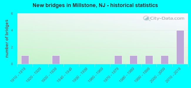
- New bridges - historical statistics
- 11910-1919
- 11930-1939
- 11970-1979
- 11980-1989
- 11990-1999
- 12000-2009
- 42010-2019


- Bridge Condition - Deck
- 33.3%Very good
- 33.3%Good
- 16.7%Satisfactory
- 16.7%Poor

- Bridge Condition - Superstructure
- 16.7%Excellent
- 33.3%Very good
- 16.7%Good
- 16.7%Satisfactory
- 16.7%Fair

- Bridge Condition - Substructure
- 16.7%Excellent
- 16.7%Very good
- 16.7%Good
- 33.3%Satisfactory
- 16.7%Fair

- Bridge Condition - Channel
- 25.0%Good
- 75.0%Satisfactory
Find on map >> Show street view
Structure Number: 1810185, Location: 6.2 MILES S OF US 202 (Lat: 40.499419, Lng: -74.634219), Route carried "on" structure: County highway 514, Year Built: 2012, Status: Open, Structure Length: 4.88m (16.01ft), Average Daily Traffic: 17,441 (year 2020), Truck Traffic: 4%, Average Future Daily Traffic: 20,929 (year 2040), Design Load: HL 93, Features Intersected: US_206
Minimum Vertical Clearance: 5.49m (18.01ft), Kilometerpoint: 22.177, Lanes on structure: 2, Lanes under structure: 4, Owner: State Highway Agency, Approaching Roadway Width: 14.4m (47.2ft), Skew: 2 degrees, Material/Design: Steel, Design/Construction: Stringer/Multi-beam, Number Of Spans In Main Unit: 1, Length of Maximum Span: 48.8m (160.1ft), Curb or Sidewalk Widths: Left: 1.8m (5.9ft), Right: 1.8m (5.9ft), Curb-To-Curb Width: 14.4m (47.2ft), Out-to-Out Width: 18.6m (61.0ft)
Condition: Deck: Very good, Superstructure: Very good, Substructure: Very good, Operating Rating: 72.6 metric tons, Method Used To Determine Operating Rating: Load and Resistance Factor Rating (LRFR) rating reported by rating factor(RF) method using HL-93 loadings, Inventory Rating: 55.7 metric tons, Method Used To Determine Inventory Rating: Load and Resistance Factor Rating (LRFR) rating reported by rating factor(RF) method using HL-93 loadings, Structural Evaluation: Equal to present desirable criteria, Deck Geometry: Superior to present desirable criteria, Underclear: Superior to present desirable criteria, Approach Roadway Alignment: Superior to present desirable criteria, Designated Inspection Frequency: Every 24 months, Inspection Date: April 2020, Deck Structure Type: Concrete Cast-file-Place, Wearing Surface/Protective System: Deck Protection: Epoxy Coated Reinforcing
Find on map >> Show street view
Structure Number: 1810186, Location: 0.4 miles north of CR514 (Lat: 40.506689, Lng: -74.635089), Route carried "on" structure: City street 9018, Year Built: 2019, Status: Open, Structure Length: 5.61m (18.41ft), Average Daily Traffic: 17,942 (year 2022), Truck Traffic: 1%, Average Future Daily Traffic: 25,753 (year 2042), Design Load: HL 93, Features Intersected: US 206 Bypass, Facility Carried by Structure: Hamilton Road
Minimum Vertical Clearance: 30+ m (98+ ft), Kilometerpoint: 0.322, Lanes on structure: 2, Lanes under structure: 4, Owner: State Highway Agency, Approaching Roadway Width: 10.8m (35.4ft), Material/Design: Steel continuous, Design/Construction: Stringer/Multi-beam, Number Of Spans In Main Unit: 2, Length of Maximum Span: 27.4m (89.9ft), Curb or Sidewalk Widths: Left: 1.8m (5.9ft), Right: 1.8m (5.9ft), Curb-To-Curb Width: 10.8m (35.4ft), Out-to-Out Width: 15.0m (49.2ft)
Condition: Deck: Very good, Superstructure: Excellent, Substructure: Excellent, Operating Rating: 55.1 metric tons, Method Used To Determine Operating Rating: Load and Resistance Factor Rating (LRFR) rating reported by rating factor(RF) method using HL-93 loadings, Inventory Rating: 42.8 metric tons, Method Used To Determine Inventory Rating: Load and Resistance Factor Rating (LRFR) rating reported by rating factor(RF) method using HL-93 loadings, Structural Evaluation: Superior to present desirable criteria, Deck Geometry: Meets minimum limits, Underclear: Superior to present desirable criteria, Approach Roadway Alignment: Equal to present desirable criteria, Designated Inspection Frequency: Every 24 months, Inspection Date: November 2021, Deck Structure Type: Concrete Cast-file-Place, Wearing Surface/Protective System: Wearing Surface: Monolithic Concrete, Deck Protection: Epoxy Coated Reinforcing
Find on map >> Show street view
Structure Number: 1850165, Location: 0.92 MI E of US206 (Lat: 40.498711, Lng: -74.628811), Route carried "on" structure: County highway 514, Year Built: 2006, Status: Open, Structure Length: 4.21m (13.81ft), Average Daily Traffic: 18,760 (year 2020), Truck Traffic: 4%, Average Future Daily Traffic: 22,890 (year 2040), Design Load: HL 93, Features Intersected: TRENTON LINE (CSXT)
Minimum Vertical Clearance: 30+ m (98+ ft), Kilometerpoint: 22.740, Lanes on structure: 2, Owner: State Highway Agency, Approaching Roadway Width: 14.3m (46.9ft), Skew: 3 degrees, Material/Design: Steel, Design/Construction: Stringer/Multi-beam, Number Of Spans In Main Unit: 1, Length of Maximum Span: 40.2m (131.9ft), Curb or Sidewalk Widths: Left: 1.8m (5.9ft), Right: 1.8m (5.9ft), Curb-To-Curb Width: 14.4m (47.2ft), Out-to-Out Width: 18.6m (61.0ft)
Condition: Deck: Good, Superstructure: Very good, Substructure: Good, Operating Rating: 83.9 metric tons, Method Used To Determine Operating Rating: Load and Resistance Factor Rating (LRFR) rating reported by rating factor(RF) method using HL-93 loadings, Inventory Rating: 64.8 metric tons, Method Used To Determine Inventory Rating: Load and Resistance Factor Rating (LRFR) rating reported by rating factor(RF) method using HL-93 loadings, Structural Evaluation: Better than present minimum criteria, Deck Geometry: Superior to present desirable criteria, Underclear: Superior to present desirable criteria, Approach Roadway Alignment: Equal to present desirable criteria, Designated Inspection Frequency: Every 24 months, Inspection Date: October 2020, Deck Structure Type: Concrete Cast-file-Place, Wearing Surface/Protective System: Wearing Surface: Integral Concrete, Deck Protection: Epoxy Coated Reinforcing
Find on map >> Show street view
Structure Number: 1850166, Location: 6.1MI S OF US22&I287 JCT (Lat: 40.506111, Lng: -74.620811), Route carried "on" structure: City street , Year Built: 1918, Status: Open, Structure Length: 2.99m (9.81ft), Average Daily Traffic: 6,302 (year 2021), Truck Traffic: 3%, Average Future Daily Traffic: 7,690 (year 2041), Features Intersected: NEW YORK BRNCH (CONRAIL), Facility Carried by Structure: HAMILTON ROAD
Minimum Vertical Clearance: 30+ m (98+ ft), Kilometerpoint: 1.561, Lanes on structure: 2, Maintenance Responsibility: State Highway Agency, Approaching Roadway Width: 5.8m (19.0ft), Skew: 4 degrees, Material/Design: Steel, Design/Construction: Girder and Floorbeam System, Number Of Spans In Main Unit: 1, Length of Maximum Span: 28.7m (94.2ft), Curb-To-Curb Width: 7.3m (24.0ft), Out-to-Out Width: 8.5m (27.9ft)
Condition: Deck: Poor, Superstructure: Fair, Substructure: Fair, Operating Rating: 25.4 metric tons, Method Used To Determine Operating Rating: Load Factor (LF), Inventory Rating: 15.4 metric tons, Method Used To Determine Inventory Rating: Load Factor (LF), Structural Evaluation: High priority of replacement, Deck Geometry: High priority of replacement, Underclear: Equal to present minimum criteria, Approach Roadway Alignment: Meets minimum limits, Length Of Structure Improvement: 3.90m (12.80ft), Designated Inspection Frequency: Every 24 months, Critical Feature Inspection Frequency: Every 24 months, Inspection Date: September 2021, Critical Feature Inspection Date: September 2021, Bridge Improvement Cost: $1,757,000, Roadway Improvement Cost: $106,000, Total Project Cost: $3,615,000 ( Estimate for 2021), Deck Structure Type: Concrete Cast-file-Place, Wearing Surface/Protective System: Wearing Surface: Bituminous
Find on map >> Show street view
Structure Number: 18F0503, Location: 1.0 MI EAST OF US206 (Lat: 40.498589, Lng: -74.626739), Route carried "on" structure: County highway 514, Year Built: 1986, Status: Open, Structure Length: 1.55m (5.09ft), Average Daily Traffic: 18,898 (year 2021), Truck Traffic: 4%, Average Future Daily Traffic: 22,678 (year 2041), Design Load: HS 20+Mod, Features Intersected: ROYCE BROOK
Minimum Vertical Clearance: 30+ m (98+ ft), Kilometerpoint: 22.885, Lanes on structure: 2, Owner: County Highway Agency, Approaching Roadway Width: 13.7m (44.9ft), Material/Design: Aluminum, Iron, Design/Construction: Culvert, Number Of Spans In Main Unit: 2, Length of Maximum Span: 7.6m (24.9ft)
Condition: Channel: Satisfactory, Culverts: Good, Structural Evaluation: Better than present minimum criteria, Waterway Adequacy: Superior to present desirable criteria, Approach Roadway Alignment: Better than present minimum criteria, Designated Inspection Frequency: Every 24 months, Inspection Date: September 2021
Find on map >> Show street view
Structure Number: 18F0507, Location: .82 MI EAST OF RT 206 (Lat: 40.505950, Lng: -74.623539), Route carried "on" structure: City street , Year Built: 1978, Status: Open, Structure Length: 2.04m (6.69ft), Average Daily Traffic: 2,566 (year 2021), Truck Traffic: 3%, Average Future Daily Traffic: 3,080 (year 2041), Design Load: HS 20, Features Intersected: ROYCE BROOK, Facility Carried by Structure: HAMILTON ROAD
Minimum Vertical Clearance: 30+ m (98+ ft), Kilometerpoint: 1.320, Lanes on structure: 2, Owner: County Highway Agency, Approaching Roadway Width: 12.2m (40.0ft), Skew: 1 degrees, Material/Design: Prestressed concrete, Design/Construction: Box Beam or Girders - Multiple, Number Of Spans In Main Unit: 1, Length of Maximum Span: 19.2m (63.0ft), Curb or Sidewalk Widths: Left: 0.9m (3.0ft), Right: 1.5m (4.9ft), Curb-To-Curb Width: 12.2m (40.0ft), Out-to-Out Width: 15.3m (50.2ft)
Condition: Deck: Satisfactory, Superstructure: Satisfactory, Substructure: Satisfactory, Channel: Satisfactory, Operating Rating: 64.4 metric tons, Method Used To Determine Operating Rating: Load Factor (LF), Inventory Rating: 37.2 metric tons, Method Used To Determine Inventory Rating: Load Factor (LF), Structural Evaluation: Equal to present minimum criteria, Deck Geometry: Equal to present minimum criteria, Waterway Adequacy: Equal to present minimum criteria, Approach Roadway Alignment: Equal to present desirable criteria, Length Of Structure Improvement: 2.04m (6.69ft), Designated Inspection Frequency: Every 24 months, Inspection Date: September 2021, Bridge Improvement Cost: $150,000, Total Project Cost: $173,000 ( Estimate for 2015), Deck Structure Type: Concrete Cast-file-Place, Wearing Surface/Protective System: Wearing Surface: Bituminous, Membrane: Preformed Fabric
Find on map >> Show street view
Structure Number: 18F0512, Location: 0.54 WEST OF CR 533 (Lat: 40.501789, Lng: -74.598531), Route carried "on" structure: County highway 514, Year Built: 1997, Status: Open, Structure Length: 0.61m (2.00ft), Average Daily Traffic: 17,761 (year 2021), Truck Traffic: 4%, Average Future Daily Traffic: 21,313 (year 2041), Features Intersected: TRIB. TO MILLSTONE RIVER
Minimum Vertical Clearance: 30+ m (98+ ft), Kilometerpoint: 25.540, Lanes on structure: 2, Owner: County Highway Agency, Approaching Roadway Width: 12.2m (40.0ft), Skew: 2 degrees, Material/Design: Concrete, Design/Construction: Culvert, Number Of Spans In Main Unit: 1, Length of Maximum Span: 6.1m (20.0ft), Curb or Sidewalk Widths: Left: 2.0m (6.6ft), Right: 2.2m (7.2ft), Curb-To-Curb Width: 12.2m (40.0ft), Out-to-Out Width: 29.0m (95.1ft)
Condition: Channel: Good, Culverts: Good, Operating Rating: 54.4 metric tons, Method Used To Determine Operating Rating: Field evaluation and documented engineering judgment, Inventory Rating: 32.7 metric tons, Method Used To Determine Inventory Rating: Field evaluation and documented engineering judgment, Structural Evaluation: Better than present minimum criteria, Deck Geometry: Somewhat better than minimum adequacy, Waterway Adequacy: Better than present minimum criteria, Approach Roadway Alignment: Equal to present desirable criteria, Designated Inspection Frequency: Every 24 months, Inspection Date: October 2021
Find on map >> Show street view
Structure Number: 18G0505, Location: 0.13 MI E OF CR 533 JCT (Lat: 40.502750, Lng: -74.587450), Route carried "on" structure: County highway 514, Year Built: 1930, Year Reconstructed: 1998, Status: Open, Structure Length: 24.84m (81.50ft), Average Daily Traffic: 15,026 (year 2021), Truck Traffic: 4%, Average Future Daily Traffic: 18,335 (year 2041), Design Load: HS 20+Mod, Features Intersected: MILLSTONE RIVER
Minimum Vertical Clearance: 30+ m (98+ ft), Kilometerpoint: 26.522, Lanes on structure: 2, Owner: County Highway Agency, Approaching Roadway Width: 9.1m (29.9ft), Material/Design: Steel continuous, Design/Construction: Stringer/Multi-beam, Number Of Spans In Main Unit: 3, Number Of Approach Spans: 25, Length of Maximum Span: 13.7m (44.9ft), Curb or Sidewalk Widths: Left: 1.6m (5.2ft), Right: 0.0m, Curb-To-Curb Width: 8.5m (27.9ft), Out-to-Out Width: 11.0m (36.1ft)
Condition: Deck: Good, Superstructure: Good, Substructure: Satisfactory, Channel: Satisfactory, Operating Rating: 83.5 metric tons, Method Used To Determine Operating Rating: Load Factor (LF), Inventory Rating: 49.9 metric tons, Method Used To Determine Inventory Rating: Load Factor (LF), Structural Evaluation: Equal to present minimum criteria, Deck Geometry: Meets minimum limits, Waterway Adequacy: Better than present minimum criteria, Approach Roadway Alignment: Equal to present desirable criteria, Designated Inspection Frequency: Every 24 months, Inspection Date: September 2021, Deck Structure Type: Concrete Cast-file-Place, Wearing Surface/Protective System: Wearing Surface: Monolithic Concrete
Find on map >> Show street view
Structure Number: 1810185, Location: 6.2 MILES S OF US 202 (Lat: 40.499419, Lng: -74.634219), Route carried "under" structure: Bypass US 206, Year Built: 2012, Structure Length: 0. m, Average Daily Traffic: 35,360 (year 2020), Truck Traffic: 1%, Features Intersected: US_206, Facility Carried by Structure: AMWELL RD - CR 514
Minimum Vertical Clearance: 5.49m (18.01ft), Kilometerpoint: 2.414, Lanes on structure: 2, Lanes under structure: 4, Material/Design: Steel, Design/Construction: Stringer/Multi-beam, Length of Maximum Span: 48.8m (160.1ft)
Find on map >> Show street view
Structure Number: 1810186, Location: 0.4 miles north of CR514 (Lat: 40.506689, Lng: -74.635089), Route carried "under" structure: Bypass US 206, Year Built: 2019, Structure Length: 0. m, Average Daily Traffic: 1,906 (year 2022), Truck Traffic: 1%, Features Intersected: US 206 Bypass, Facility Carried by Structure: Hamilton Road
Minimum Vertical Clearance: 5.59m (18.34ft), Kilometerpoint: 0.016, Lanes on structure: 2, Lanes under structure: 4, Material/Design: Steel continuous, Design/Construction: Stringer/Multi-beam, Length of Maximum Span: 27.4m (89.9ft)