Bridge Statistics for Milltown, Indiana (IN)
Condition, Traffic, Stress, Structural Evaluation, Project Costs
- National Bridge Inventory (NBI) Statistics
- 12Number of bridges
- 108ft / 32.9mTotal length
- $1,881,000Total costs
- 16,247Total average daily traffic
- 1,685Total average daily truck traffic
- 25,728Total future (year 2030) average daily traffic
- National Bridge Inventory (NBI) Registered Bridges for Milltown
- No street view available for this location
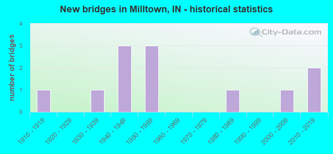
- New bridges - historical statistics
- 11910-1919
- 11930-1939
- 31940-1949
- 31950-1959
- 11980-1989
- 12000-2009
- 22010-2019

- Reconstructed bridges - Historical Statistics
- 11980-1989
- 21990-1999


- Bridge Condition - Deck
- 10.0%Very good
- 30.0%Good
- 40.0%Satisfactory
- 10.0%Fair
- 10.0%Poor

- Bridge Condition - Superstructure
- 18.2%Very good
- 27.3%Good
- 27.3%Satisfactory
- 18.2%Fair
- 9.1%Poor

- Bridge Condition - Substructure
- 27.3%Very good
- 18.2%Good
- 9.1%Satisfactory
- 36.4%Fair
- 9.1%Poor

- Bridge Condition - Channel
- 54.5%Good
- 27.3%Satisfactory
- 18.2%Fair
Find on map >> Show street view
Structure Number: 2312, Location: 00.29 E SR 66 (Lat: 38.352519, Lng: -86.278750), Route carried "on" structure: State highway 64, Year Built: 1958, Year Reconstructed: 1998, Status: Open, Structure Length: 8.23m (27.00ft), Average Daily Traffic: 4,666 (year 2004), Truck Traffic: 10%, Average Future Daily Traffic: 8,181 (year 2031), Design Load: HS 20, Features Intersected: BLUE RIVER
Minimum Vertical Clearance: 30+ m (98+ ft), Kilometerpoint: 38.640, Lanes on structure: 2, Owner: State Highway Agency, Approaching Roadway Width: 11.0m (36.1ft), Material/Design: Concrete, Design/Construction: Arch - Deck, Number Of Spans In Main Unit: 3, Length of Maximum Span: 25.9m (85.0ft), Curb-To-Curb Width: 10.9m (35.8ft), Out-to-Out Width: 11.8m (38.7ft)
Condition: Deck: Satisfactory, Superstructure: Good, Substructure: Satisfactory, Channel: Satisfactory, Operating Rating: 70.9 metric tons, Method Used To Determine Operating Rating: Field evaluation and documented engineering judgment, Inventory Rating: 42.4 metric tons, Method Used To Determine Inventory Rating: Field evaluation and documented engineering judgment, Structural Evaluation: Equal to present minimum criteria, Deck Geometry: Somewhat better than minimum adequacy, Waterway Adequacy: Better than present minimum criteria, Approach Roadway Alignment: Equal to present desirable criteria, Designated Inspection Frequency: Every 24 months, Inspection Date: October 2020, Deck Structure Type: Concrete Cast-file-Place, Wearing Surface/Protective System: Wearing Surface: Monolithic Concrete, Deck Protection: Epoxy Coated Reinforcing
Find on map >> Show street view
Structure Number: 2313, Location: 00.11 E SR 337 (Lat: 38.335511, Lng: -86.216031), Route carried "on" structure: State highway 64, Year Built: 1950, Status: Open, Structure Length: 0.79m (2.59ft), Average Daily Traffic: 7,221 (year 2004), Truck Traffic: 10%, Average Future Daily Traffic: 12,058 (year 2030), Design Load: H 20, Features Intersected: BRANCH BLUE RIVER
Minimum Vertical Clearance: 30+ m (98+ ft), Kilometerpoint: 6.180, Lanes on structure: 2, Owner: State Highway Agency, Approaching Roadway Width: 7.9m (25.9ft), Skew: 4 degrees, Material/Design: Concrete, Design/Construction: Culvert, Number Of Spans In Main Unit: 1, Length of Maximum Span: 7.3m (24.0ft), Curb-To-Curb Width: 9.4m (30.8ft), Out-to-Out Width: 9.4m (30.8ft)
Condition: Channel: Good, Culverts: Fair, Operating Rating: 54.5 metric tons, Method Used To Determine Operating Rating: Field evaluation and documented engineering judgment, Inventory Rating: 32.7 metric tons, Method Used To Determine Inventory Rating: Field evaluation and documented engineering judgment, Structural Evaluation: Somewhat better than minimum adequacy, Deck Geometry: High priority of corrective action, Waterway Adequacy: Equal to present minimum criteria, Approach Roadway Alignment: Equal to present desirable criteria, Length Of Structure Improvement: 1.83m (6.00ft), Designated Inspection Frequency: Every 24 months, Inspection Date: October 2020, Bridge Improvement Cost: $111,000, Total Project Cost: $111,000
Find on map >> Show street view
Structure Number: 1300004, Location: 0.80 E OF SR 66 (Lat: 38.377050, Lng: -86.259350), Route carried "on" structure: County highway 218, Year Built: 1910, Year Reconstructed: 1995, Status: Posted for load, Structure Length: 4.94m (16.21ft), Average Daily Traffic: 411 (year 2015), Truck Traffic: 10%, Average Future Daily Traffic: 489 (year 2035), Features Intersected: BLUE RIVER, Facility Carried by Structure: CR 590 NORTH
Minimum Vertical Clearance: 5.18m (16.99ft), Kilometerpoint: 0.000, Lanes on structure: 1, Owner: County Highway Agency, Approaching Roadway Width: 4.3m (14.1ft), Navigation Control: Yes ( Vertical Clearance: 7.3m (24.0ft), Horizontal Clearance: 33.2m (108.9ft)), Material/Design: Steel, Design/Construction: Truss - Thru, Number Of Spans In Main Unit: 1, Length of Maximum Span: 47.7m (156.5ft), Curb-To-Curb Width: 4.0m (13.1ft), Out-to-Out Width: 4.3m (14.1ft)
Condition: Deck: Satisfactory, Superstructure: Fair, Substructure: Fair, Channel: Good, Operating Rating: 29.6 metric tons, Method Used To Determine Operating Rating: Load Factor (LF), Inventory Rating: 14.0 metric tons, Method Used To Determine Inventory Rating: Load Factor (LF), Structural Evaluation: Meets minimum limits, Deck Geometry: High priority of replacement, Waterway Adequacy: Better than present minimum criteria, Approach Roadway Alignment: Equal to present minimum criteria, Bridge Posting: Required (Relationship of Operating Rating to Maximum Legal Load: 30.0 - 39.9% below), Length Of Structure Improvement: 4.91m (16.11ft), Designated Inspection Frequency: Every 24 months, Critical Feature Inspection Frequency: Every 24 months, Other Special Inspection Frequency: Every 24 months, Inspection Date: September 2021, Critical Feature Inspection Date: September 2021, Other Special Inspection Date: September 2020, Bridge Improvement Cost: $575,000, Roadway Improvement Cost: $100,000, Total Project Cost: $675,000 ( Estimate for 2021), Deck Structure Type: Open Grating
Find on map >> Show street view
Structure Number: 1300018, Location: 0.00 S OF PILOT KNOB (Lat: 38.316761, Lng: -86.290481), Route carried "on" structure: Alternate County highway , Year Built: 1940, Status: Open, Structure Length: 1.76m (5.77ft), Average Daily Traffic: 680 (year 2015), Truck Traffic: 12%, Average Future Daily Traffic: 809 (year 2035), Features Intersected: SLICK RUN, Facility Carried by Structure: MILLTOWN ROAD
Minimum Vertical Clearance: 30+ m (98+ ft), Kilometerpoint: 0.000, Lanes on structure: 2, Owner: County Highway Agency, Approaching Roadway Width: 4.9m (16.1ft), Material/Design: Steel, Design/Construction: Stringer/Multi-beam, Number Of Spans In Main Unit: 1, Length of Maximum Span: 16.7m (54.8ft), Curb-To-Curb Width: 5.9m (19.4ft), Out-to-Out Width: 6.1m (20.0ft)
Condition: Deck: Satisfactory, Superstructure: Fair, Substructure: Fair, Channel: Fair, Operating Rating: 47.6 metric tons, Method Used To Determine Operating Rating: Load and Resistance Factor (LRFR), Inventory Rating: 44.2 metric tons, Method Used To Determine Inventory Rating: Load and Resistance Factor (LRFR), Structural Evaluation: Somewhat better than minimum adequacy, Deck Geometry: High priority of replacement, Waterway Adequacy: Somewhat better than minimum adequacy, Approach Roadway Alignment: Equal to present minimum criteria, Designated Inspection Frequency: Every 24 months, Inspection Date: September 2021, Deck Structure Type: Concrete Cast-file-Place, Wearing Surface/Protective System: Wearing Surface: Bituminous
Find on map >> Show street view
Structure Number: 1300022, Location: 0.0 E OF SLICK CREEK ROAD (Lat: 38.316619, Lng: -86.307219), Route carried "on" structure: Alternate County highway , Year Built: 1935, Year Reconstructed: 1989, Status: Posted for load, Structure Length: 0.94m (3.08ft), Average Daily Traffic: 271 (year 2015), Truck Traffic: 10%, Average Future Daily Traffic: 323 (year 2035), Features Intersected: SLICK RUN, Facility Carried by Structure: PILOT KNOB ROAD
Minimum Vertical Clearance: 30+ m (98+ ft), Kilometerpoint: 0.000, Lanes on structure: 2, Owner: County Highway Agency, Approaching Roadway Width: 4.9m (16.1ft), Material/Design: Steel, Design/Construction: Stringer/Multi-beam, Number Of Spans In Main Unit: 1, Length of Maximum Span: 9.0m (29.5ft), Curb-To-Curb Width: 5.6m (18.4ft), Out-to-Out Width: 5.6m (18.4ft)
Condition: Deck: Satisfactory, Superstructure: Satisfactory, Substructure: Fair, Channel: Fair, Operating Rating: 15.3 metric tons, Method Used To Determine Operating Rating: Load Factor (LF), Inventory Rating: 9.1 metric tons, Method Used To Determine Inventory Rating: Load Factor (LF), Structural Evaluation: High priority of replacement, Deck Geometry: High priority of corrective action, Waterway Adequacy: Somewhat better than minimum adequacy, Approach Roadway Alignment: Equal to present desirable criteria, Bridge Posting: Required (Relationship of Operating Rating to Maximum Legal Load: > 39.9% below), Length Of Structure Improvement: 1.52m (4.99ft), Designated Inspection Frequency: Every 24 months, Inspection Date: September 2021, Bridge Improvement Cost: $270,000, Roadway Improvement Cost: $175,000, Total Project Cost: $445,000 ( Estimate for 2021), Deck Structure Type: Concrete Cast-file-Place, Wearing Surface/Protective System: Wearing Surface: Bituminous
Find on map >> Show street view
Structure Number: 1300038, Location: 0.10 S OF SEACAT LANE (Lat: 38.352150, Lng: -86.283681), Route carried "on" structure: Alternate County highway , Year Built: 1950, Status: Open, Structure Length: 4.11m (13.48ft), Average Daily Traffic: 1,754 (year 2015), Truck Traffic: 15%, Average Future Daily Traffic: 2,086 (year 2035), Features Intersected: WHISKEY RUN, Facility Carried by Structure: MILLTOWN ROAD
Minimum Vertical Clearance: 30+ m (98+ ft), Kilometerpoint: 0.000, Lanes on structure: 2, Owner: County Highway Agency, Approaching Roadway Width: 6.1m (20.0ft), Skew: 1 degrees, Material/Design: Concrete, Design/Construction: Arch - Deck, Number Of Spans In Main Unit: 3, Length of Maximum Span: 25.6m (84.0ft), Curb-To-Curb Width: 8.6m (28.2ft), Out-to-Out Width: 9.6m (31.5ft)
Condition: Superstructure: Satisfactory, Substructure: Good, Channel: Good, Operating Rating: 54.5 metric tons, Method Used To Determine Operating Rating: Field evaluation and documented engineering judgment, Inventory Rating: 32.7 metric tons, Method Used To Determine Inventory Rating: Field evaluation and documented engineering judgment, Structural Evaluation: Equal to present minimum criteria, Deck Geometry: Somewhat better than minimum adequacy, Waterway Adequacy: Better than present minimum criteria, Approach Roadway Alignment: Equal to present desirable criteria, Designated Inspection Frequency: Every 24 months, Inspection Date: September 2021, Wearing Surface/Protective System: Wearing Surface: Bituminous
Find on map >> Show street view
Structure Number: 130009, Location: 0.40 W OF MIFFLIN FK ROAD (Lat: 38.266831, Lng: -86.568931), Route carried "on" structure: Alternate County highway , Year Built: 1940, Status: Posted for load, Structure Length: 0.67m (2.20ft), Average Daily Traffic: 57 (year 2015), Average Future Daily Traffic: 68 (year 2035), Features Intersected: STINKING FORK, Facility Carried by Structure: WEST FORK ROAD
Minimum Vertical Clearance: 30+ m (98+ ft), Kilometerpoint: 0.000, Lanes on structure: 2, Owner: County Highway Agency, Approaching Roadway Width: 3.0m (9.8ft), Material/Design: Steel, Design/Construction: Stringer/Multi-beam, Number Of Spans In Main Unit: 1, Length of Maximum Span: 6.1m (20.0ft), Curb-To-Curb Width: 5.1m (16.7ft), Out-to-Out Width: 5.1m (16.7ft)
Condition: Deck: Fair, Superstructure: Satisfactory, Substructure: Fair, Channel: Satisfactory, Operating Rating: 16.0 metric tons, Method Used To Determine Operating Rating: Load Factor (LF), Inventory Rating: 9.5 metric tons, Method Used To Determine Inventory Rating: Load Factor (LF), Structural Evaluation: High priority of replacement, Deck Geometry: High priority of corrective action, Waterway Adequacy: Somewhat better than minimum adequacy, Approach Roadway Alignment: Equal to present desirable criteria, Bridge Posting: Required (Relationship of Operating Rating to Maximum Legal Load: > 39.9% below), Length Of Structure Improvement: 1.22m (4.00ft), Designated Inspection Frequency: Every 24 months, Inspection Date: September 2021, Bridge Improvement Cost: $200,000, Roadway Improvement Cost: $100,000, Total Project Cost: $300,000 ( Estimate for 2021), Deck Structure Type: Concrete Cast-file-Place, Wearing Surface/Protective System: Wearing Surface: Monolithic Concrete
Find on map >> Show street view
Structure Number: 1300092, Location: 0.00 E OF BACK STREET (Lat: 38.340600, Lng: -86.273569), Route carried "on" structure: City street , Year Built: 2010, Status: Open, Structure Length: 5.55m (18.21ft), Average Daily Traffic: 141 (year 2015), Truck Traffic: 5%, Average Future Daily Traffic: 168 (year 2035), Design Load: HS 20, Features Intersected: BLUE RIVER, Facility Carried by Structure: MAIN STREET
Minimum Vertical Clearance: 30+ m (98+ ft), Kilometerpoint: 0.000, Lanes on structure: 2, Owner: County Highway Agency, Approaching Roadway Width: 7.3m (24.0ft), Navigation Control: Yes ( Vertical Clearance: 6.1m (20.0ft), Horizontal Clearance: 41.6m (136.5ft)), Material/Design: Steel, Design/Construction: Truss - Thru, Number Of Spans In Main Unit: 1, Number Of Approach Spans: 1, Length of Maximum Span: 42.4m (139.1ft), Curb or Sidewalk Widths: Left: 0.0m, Right: 1.2m (3.9ft), Curb-To-Curb Width: 7.3m (24.0ft), Out-to-Out Width: 8.5m (27.9ft)
Condition: Deck: Good, Superstructure: Good, Substructure: Good, Channel: Good, Operating Rating: 74.8 metric tons, Method Used To Determine Operating Rating: Load Factor (LF), Inventory Rating: 44.7 metric tons, Method Used To Determine Inventory Rating: Load Factor (LF), Structural Evaluation: Better than present minimum criteria, Deck Geometry: Somewhat better than minimum adequacy, Waterway Adequacy: Equal to present minimum criteria, Approach Roadway Alignment: Equal to present minimum criteria, Designated Inspection Frequency: Every 24 months, Critical Feature Inspection Frequency: Every 24 months, Inspection Date: September 2021, Critical Feature Inspection Date: September 2021, Deck Structure Type: Concrete Cast-file-Place, Wearing Surface/Protective System: Wearing Surface: Monolithic Concrete, Deck Protection: Epoxy Coated Reinforcing
Find on map >> Show street view
Structure Number: 1300102, Location: 0.10 N OF ZELLER ROAD (Lat: 38.247511, Lng: -86.527200), Route carried "on" structure: Alternate County highway 59, Year Built: 1940, Status: Posted for load, Structure Length: 0.67m (2.20ft), Average Daily Traffic: 145 (year 2015), Truck Traffic: 5%, Average Future Daily Traffic: 173 (year 2035), Features Intersected: REASOR BRANCH, Facility Carried by Structure: ECKERT ROAD
Minimum Vertical Clearance: 30+ m (98+ ft), Kilometerpoint: 0.000, Lanes on structure: 2, Owner: County Highway Agency, Approaching Roadway Width: 4.9m (16.1ft), Material/Design: Steel, Design/Construction: Stringer/Multi-beam, Number Of Spans In Main Unit: 1, Length of Maximum Span: 6.1m (20.0ft), Curb-To-Curb Width: 6.5m (21.3ft), Out-to-Out Width: 7.5m (24.6ft)
Condition: Deck: Poor, Superstructure: Poor, Substructure: Poor, Channel: Satisfactory, Operating Rating: 15.4 metric tons, Method Used To Determine Operating Rating: Load Factor (LF), Inventory Rating: 9.2 metric tons, Method Used To Determine Inventory Rating: Load Factor (LF), Structural Evaluation: High priority of replacement, Deck Geometry: Meets minimum limits, Waterway Adequacy: Equal to present minimum criteria, Approach Roadway Alignment: Equal to present desirable criteria, Bridge Posting: Required (Relationship of Operating Rating to Maximum Legal Load: > 39.9% below), Length Of Structure Improvement: 1.22m (4.00ft), Designated Inspection Frequency: Every 12 months, Inspection Date: September 2021, Bridge Improvement Cost: $200,000, Roadway Improvement Cost: $150,000, Total Project Cost: $350,000 ( Estimate for 2021), Deck Structure Type: Concrete Cast-file-Place, Wearing Surface/Protective System: Wearing Surface: Bituminous
Find on map >> Show street view
Structure Number: 1300104, Location: 0.30 S OF SEACAT LANE (Lat: 38.348031, Lng: -86.283169), Route carried "on" structure: Alternate City street , Year Built: 2017, Status: Open, Structure Length: 3.51m (11.52ft), Average Daily Traffic: 261 (year 2013), Truck Traffic: 15%, Average Future Daily Traffic: 323 (year 2035), Design Load: HL 93, Features Intersected: NORFOLK SOUTHERN RR, Facility Carried by Structure: MAIN STREET
Minimum Vertical Clearance: 30+ m (98+ ft), Kilometerpoint: 0.000, Lanes on structure: 2, Owner: County Highway Agency, Approaching Roadway Width: 6.4m (21.0ft), Skew: 4 degrees, Material/Design: Prestressed concrete, Design/Construction: Stringer/Multi-beam, Number Of Spans In Main Unit: 1, Length of Maximum Span: 33.5m (109.9ft), Curb-To-Curb Width: 11.2m (36.7ft), Out-to-Out Width: 12.0m (39.4ft)
Condition: Deck: Very good, Superstructure: Very good, Substructure: Very good, Operating Rating: 68.6 metric tons, Method Used To Determine Operating Rating: Load and Resistance Factor (LRFR), Inventory Rating: 50.9 metric tons, Method Used To Determine Inventory Rating: Load and Resistance Factor (LRFR), Structural Evaluation: Equal to present desirable criteria, Deck Geometry: Superior to present desirable criteria, Underclear: Equal to present desirable criteria, Approach Roadway Alignment: Equal to present desirable criteria, Designated Inspection Frequency: Every 24 months, Inspection Date: September 2021, Deck Structure Type: Concrete Cast-file-Place, Wearing Surface/Protective System: Wearing Surface: Monolithic Concrete
Find on map >> Show street view
Structure Number: 3100055, Location: 01.00 W OF ROTHROCK MILL (Lat: 38.306161, Lng: -86.255517), Route carried "on" structure: Alternate County highway , Year Built: 2000, Status: Open, Structure Length: 0.87m (2.85ft), Average Daily Traffic: 360 (year 2018), Truck Traffic: 5%, Average Future Daily Traffic: 590 (year 2038), Design Load: HS 20, Features Intersected: NO NAME CREEK, Facility Carried by Structure: SOUTH ST LOUIS RD
Minimum Vertical Clearance: 30+ m (98+ ft), Kilometerpoint: 0.000, Lanes on structure: 2, Owner: County Highway Agency, Approaching Roadway Width: 6.7m (22.0ft), Skew: 4 degrees, Material/Design: Concrete, Design/Construction: Slab, Number Of Spans In Main Unit: 1, Length of Maximum Span: 7.6m (24.9ft), Curb-To-Curb Width: 7.6m (24.9ft), Out-to-Out Width: 7.6m (24.9ft)
Condition: Deck: Good, Superstructure: Good, Substructure: Very good, Channel: Good, Operating Rating: 57.4 metric tons, Method Used To Determine Operating Rating: Load Factor (LF), Inventory Rating: 34.4 metric tons, Method Used To Determine Inventory Rating: Load Factor (LF), Structural Evaluation: Better than present minimum criteria, Deck Geometry: Somewhat better than minimum adequacy, Waterway Adequacy: Better than present minimum criteria, Approach Roadway Alignment: Equal to present minimum criteria, Designated Inspection Frequency: Every 24 months, Inspection Date: August 2020, Deck Structure Type: Concrete Cast-file-Place, Wearing Surface/Protective System: Wearing Surface: Monolithic Concrete
Find on map >> Show street view
Structure Number: 310006, Location: 00.20 S OF HUGGINS RD (Lat: 38.325439, Lng: -86.273253), Route carried "on" structure: Alternate County highway , Year Built: 1987, Status: Open, Structure Length: 0.89m (2.92ft), Average Daily Traffic: 280 (year 2018), Truck Traffic: 5%, Average Future Daily Traffic: 460 (year 2038), Design Load: HS 20, Features Intersected: BRANCH OF BLUE RIVER, Facility Carried by Structure: HILLVIEW RD
Minimum Vertical Clearance: 30+ m (98+ ft), Kilometerpoint: 0.000, Lanes on structure: 2, Owner: County Highway Agency, Approaching Roadway Width: 7.0m (23.0ft), Skew: 1 degrees, Material/Design: Prestressed concrete, Design/Construction: Box Beam or Girders - Multiple, Number Of Spans In Main Unit: 1, Length of Maximum Span: 7.8m (25.6ft), Curb-To-Curb Width: 7.4m (24.3ft), Out-to-Out Width: 7.4m (24.3ft)
Condition: Deck: Good, Superstructure: Very good, Substructure: Very good, Channel: Good, Operating Rating: 70.9 metric tons, Method Used To Determine Operating Rating: Load and Resistance Factor (LRFR), Inventory Rating: 58.7 metric tons, Method Used To Determine Inventory Rating: Load and Resistance Factor (LRFR), Structural Evaluation: Equal to present desirable criteria, Deck Geometry: Somewhat better than minimum adequacy, Waterway Adequacy: Equal to present desirable criteria, Approach Roadway Alignment: Equal to present minimum criteria, Designated Inspection Frequency: Every 24 months, Inspection Date: August 2020, Deck Structure Type: Concrete Cast-file-Place, Wearing Surface/Protective System: Wearing Surface: Monolithic Concrete