Bridge Statistics for Milton-Freewater, Oregon (OR)
Condition, Traffic, Stress, Structural Evaluation, Project Costs
- National Bridge Inventory (NBI) Statistics
- 14Number of bridges
- 131ft / 40.5mTotal length
- $2,293,000Total costs
- 36,107Total average daily traffic
- 2,930Total average daily truck traffic
- National Bridge Inventory (NBI) Registered Bridges for Milton-Freewater
- No street view available for this location
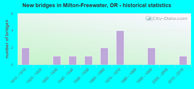
- New bridges - historical statistics
- 21910-1919
- 11930-1939
- 11940-1949
- 11950-1959
- 21960-1969
- 41970-1979
- 21990-1999
- 12010-2019
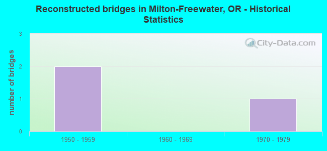
- Reconstructed bridges - Historical Statistics
- 21950-1959
- 01960-1969
- 11970-1979
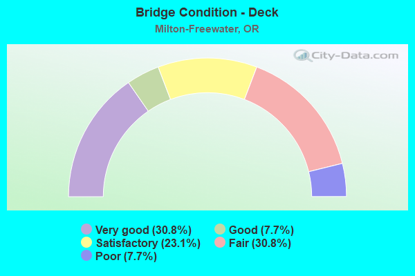
- Bridge Condition - Deck
- 30.8%Very good
- 7.7%Good
- 23.1%Satisfactory
- 30.8%Fair
- 7.7%Poor
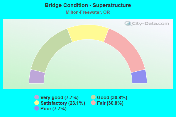
- Bridge Condition - Superstructure
- 7.7%Very good
- 30.8%Good
- 23.1%Satisfactory
- 30.8%Fair
- 7.7%Poor
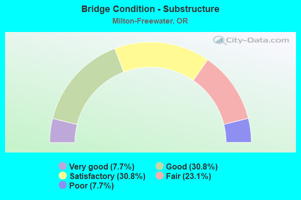
- Bridge Condition - Substructure
- 7.7%Very good
- 30.8%Good
- 30.8%Satisfactory
- 23.1%Fair
- 7.7%Poor
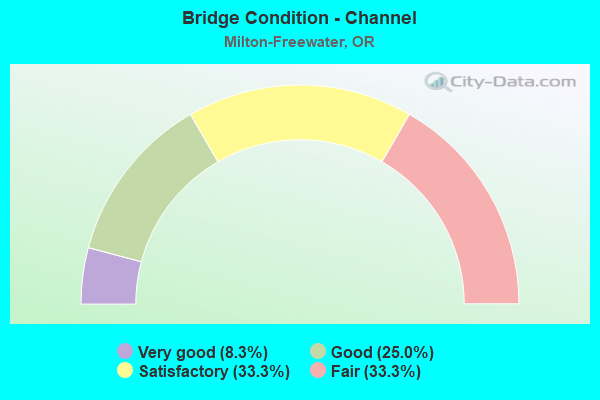
- Bridge Condition - Channel
- 8.3%Very good
- 25.0%Good
- 33.3%Satisfactory
- 33.3%Fair
Find on map >> Show street view
Structure Number: 4703 339 00331, Location: 2.0 MI. N. JCT. OR 11 (Lat: 45.952892, Lng: -118.402739), Route carried "on" structure: State highway 339, Year Built: 1919, Year Reconstructed: 1955, Status: Posted for load, Structure Length: 0.69m (2.26ft), Average Daily Traffic: 1,487 (year 2020), Truck Traffic: 11%, Average Future Daily Traffic: 1,600 (year 2040), Design Load: H 15, Features Intersected: W F LITTLE WALLA WALLA
Minimum Vertical Clearance: 30+ m (98+ ft), Kilometerpoint: 5.327, Lanes on structure: 2, Owner: State Highway Agency, Approaching Roadway Width: 7.3m (24.0ft), Material/Design: Steel, Design/Construction: Stringer/Multi-beam, Number Of Spans In Main Unit: 1, Length of Maximum Span: 6.4m (21.0ft), Curb-To-Curb Width: 8.1m (26.6ft), Out-to-Out Width: 9.4m (30.8ft)
Condition: Deck: Satisfactory, Superstructure: Satisfactory, Substructure: Fair, Channel: Fair, Operating Rating: 28.8 metric tons, Method Used To Determine Operating Rating: Field evaluation and documented engineering judgment, Inventory Rating: 22.2 metric tons, Method Used To Determine Inventory Rating: Field evaluation and documented engineering judgment, Structural Evaluation: Somewhat better than minimum adequacy, Deck Geometry: Meets minimum limits, Waterway Adequacy: Equal to present minimum criteria, Approach Roadway Alignment: Equal to present desirable criteria, Bridge Posting: Required (Relationship of Operating Rating to Maximum Legal Load: 10.0 - 19.9% below), Designated Inspection Frequency: Every 24 months, Inspection Date: December 2021, Deck Structure Type: Concrete Cast-file-Place, Wearing Surface/Protective System: Wearing Surface: Bituminous
Find on map >> Show street view
Structure Number: 4704 339 00316, Location: 2.1 MI. N. JCT. OR 11 (Lat: 45.955019, Lng: -118.402711), Route carried "on" structure: State highway 339, Year Built: 1919, Year Reconstructed: 1955, Status: Posted for load, Structure Length: 0.69m (2.26ft), Average Daily Traffic: 1,487 (year 2020), Truck Traffic: 11%, Average Future Daily Traffic: 1,600 (year 2040), Design Load: H 15, Features Intersected: E F LITTLE WALLA WALLA
Minimum Vertical Clearance: 30+ m (98+ ft), Kilometerpoint: 5.086, Lanes on structure: 2, Owner: State Highway Agency, Approaching Roadway Width: 7.3m (24.0ft), Material/Design: Steel, Design/Construction: Stringer/Multi-beam, Number Of Spans In Main Unit: 1, Length of Maximum Span: 6.4m (21.0ft), Curb-To-Curb Width: 8.1m (26.6ft), Out-to-Out Width: 9.4m (30.8ft)
Condition: Deck: Satisfactory, Superstructure: Fair, Substructure: Fair, Channel: Satisfactory, Operating Rating: 28.8 metric tons, Method Used To Determine Operating Rating: Field evaluation and documented engineering judgment, Inventory Rating: 22.2 metric tons, Method Used To Determine Inventory Rating: Field evaluation and documented engineering judgment, Structural Evaluation: Somewhat better than minimum adequacy, Deck Geometry: Meets minimum limits, Waterway Adequacy: Equal to present minimum criteria, Approach Roadway Alignment: Equal to present desirable criteria, Bridge Posting: Required (Relationship of Operating Rating to Maximum Legal Load: 10.0 - 19.9% below), Designated Inspection Frequency: Every 24 months, Inspection Date: December 2021, Deck Structure Type: Concrete Precast Panels, Wearing Surface/Protective System: Wearing Surface: Bituminous
Find on map >> Show street view
Structure Number: 6677A008 03075, Location: 4.6 MI. S. WASH. ST LINE (Lat: 45.934753, Lng: -118.387661), Route carried "on" structure: State highway 11, Year Built: 1948, Year Reconstructed: 1975, Status: Open, Structure Length: 0.67m (2.20ft), Average Daily Traffic: 10,131 (year 2020), Truck Traffic: 7%, Average Future Daily Traffic: 10,700 (year 2040), Design Load: H 15, Features Intersected: LITTLE WALLA WALLA RIVER
Minimum Vertical Clearance: 30+ m (98+ ft), Kilometerpoint: 49.487, Lanes on structure: 5, Base Highway Network: Yes, Owner: State Highway Agency, Approaching Roadway Width: 25.6m (84.0ft), Material/Design: Concrete continuous, Design/Construction: Frame, Number Of Spans In Main Unit: 1, Length of Maximum Span: 6.1m (20.0ft), Curb or Sidewalk Widths: Left: 1.8m (5.9ft), Right: 1.8m (5.9ft), Curb-To-Curb Width: 25.6m (84.0ft), Out-to-Out Width: 29.3m (96.1ft)
Condition: Deck: Fair, Superstructure: Fair, Substructure: Fair, Channel: Satisfactory, Operating Rating: 29.0 metric tons, Method Used To Determine Operating Rating: Load Factor (LF), Inventory Rating: 17.2 metric tons, Method Used To Determine Inventory Rating: Load Factor (LF), Structural Evaluation: Meets minimum limits, Deck Geometry: Superior to present desirable criteria, Waterway Adequacy: Equal to present desirable criteria, Approach Roadway Alignment: Equal to present desirable criteria, Designated Inspection Frequency: Every 24 months, Inspection Date: July 2021, Deck Structure Type: Concrete Cast-file-Place, Wearing Surface/Protective System: Wearing Surface: Monolithic Concrete
Find on map >> Show street view
Structure Number: 6979A008 03139, Location: 3.9 MI. S. WASH. ST. LINE (Lat: 45.943889, Lng: -118.387492), Route carried "on" structure: Ramp City street 11, Year Built: 1975, Status: Open, Structure Length: 5.39m (17.68ft), Average Daily Traffic: 8,390 (year 2020), Truck Traffic: 7%, Average Future Daily Traffic: 8,700 (year 2040), Design Load: HS 20, Features Intersected: HWY 8 (EASTSIDE), Facility Carried by Structure: 8TH AVE (EASTSIDE)
Minimum Vertical Clearance: 30+ m (98+ ft), Kilometerpoint: 50.517, Lanes on structure: 2, Lanes under structure: 5, Owner: State Highway Agency, Approaching Roadway Width: 8.5m (27.9ft), Skew: 1 degrees, Material/Design: Concrete continuous, Design/Construction: Box Beam or Girders - Single/Spread, Number Of Spans In Main Unit: 3, Length of Maximum Span: 36.9m (121.1ft), Curb or Sidewalk Widths: Left: 2.4m (7.9ft), Right: 0.0m, Curb-To-Curb Width: 9.8m (32.2ft), Out-to-Out Width: 13.4m (44.0ft)
Condition: Deck: Satisfactory, Superstructure: Satisfactory, Substructure: Good, Operating Rating: 45.4 metric tons, Method Used To Determine Operating Rating: Load and Resistance Factor Rating (LRFR) rating reported by rating factor(RF) method using HL-93 loadings, Inventory Rating: 35.0 metric tons, Method Used To Determine Inventory Rating: Load and Resistance Factor Rating (LRFR) rating reported by rating factor(RF) method using HL-93 loadings, Structural Evaluation: Equal to present minimum criteria, Deck Geometry: Equal to present minimum criteria, Underclear: Somewhat better than minimum adequacy, Approach Roadway Alignment: Equal to present desirable criteria, Designated Inspection Frequency: Every 24 months, Inspection Date: July 2021, Deck Structure Type: Concrete Cast-file-Place, Wearing Surface/Protective System: Wearing Surface: Monolithic Concrete
Find on map >> Show street view
Structure Number: 22333 550 00006, Location: 0.25 MI E OF TUM-A-LUM RD (Lat: 45.976667, Lng: -118.376389), Route carried "on" structure: County highway , Year Built: 2018, Status: Open, Structure Length: 6.10m (20.01ft), Average Daily Traffic: 893 (year 2011), Truck Traffic: 14%, Average Future Daily Traffic: 1,200 (year 2020), Design Load: HL 93, Features Intersected: WALLA WALLA RIVER, Facility Carried by Structure: BIRCH CREEK ROAD
Minimum Vertical Clearance: 30+ m (98+ ft), Kilometerpoint: 0.097, Lanes on structure: 2, Owner: County Highway Agency, Approaching Roadway Width: 10.4m (34.1ft), Material/Design: Steel, Design/Construction: Stringer/Multi-beam, Number Of Spans In Main Unit: 1, Length of Maximum Span: 59.7m (195.9ft), Curb-To-Curb Width: 10.4m (34.1ft), Out-to-Out Width: 11.3m (37.1ft)
Condition: Deck: Very good, Superstructure: Very good, Substructure: Very good, Channel: Very good, Operating Rating: 67.1 metric tons, Method Used To Determine Operating Rating: Load and Resistance Factor Rating (LRFR) rating reported by rating factor(RF) method using HL-93 loadings, Inventory Rating: 51.8 metric tons, Method Used To Determine Inventory Rating: Load and Resistance Factor Rating (LRFR) rating reported by rating factor(RF) method using HL-93 loadings, Structural Evaluation: Equal to present desirable criteria, Deck Geometry: Equal to present minimum criteria, Waterway Adequacy: Equal to present desirable criteria, Approach Roadway Alignment: Equal to present desirable criteria, Designated Inspection Frequency: Every 24 months, Inspection Date: July 2021, Deck Structure Type: Concrete Cast-file-Place, Wearing Surface/Protective System: Wearing Surface: Monolithic Concrete, Deck Protection: Epoxy Coated Reinforcing
Find on map >> Show street view
Structure Number: 59C425052500035, Location: 0.4 MI E OF HWY 11 (Lat: 45.921492, Lng: -118.374144), Route carried "on" structure: County highway , Year Built: 1977, Status: Open, Structure Length: 4.82m (15.81ft), Average Daily Traffic: 2,251 (year 2020), Truck Traffic: 10%, Average Future Daily Traffic: 2,551 (year 2025), Design Load: HS 20, Features Intersected: WALLA WALLA RIVER, Facility Carried by Structure: SE 15TH STREET
Minimum Vertical Clearance: 30+ m (98+ ft), Kilometerpoint: 0.563, Lanes on structure: 2, Owner: County Highway Agency, Approaching Roadway Width: 7.9m (25.9ft), Skew: 1 degrees, Material/Design: Prestressed concrete, Design/Construction: Box Beam or Girders - Multiple, Number Of Spans In Main Unit: 1, Number Of Approach Spans: 2, Length of Maximum Span: 26.8m (87.9ft), Curb-To-Curb Width: 11.4m (37.4ft), Out-to-Out Width: 12.2m (40.0ft)
Condition: Deck: Very good, Superstructure: Good, Substructure: Good, Channel: Good, Operating Rating: 65.3 metric tons, Method Used To Determine Operating Rating: Allowable Stress (AS), Inventory Rating: 39.0 metric tons, Method Used To Determine Inventory Rating: Allowable Stress (AS), Structural Evaluation: Better than present minimum criteria, Deck Geometry: Somewhat better than minimum adequacy, Waterway Adequacy: Equal to present desirable criteria, Approach Roadway Alignment: Equal to present desirable criteria, Designated Inspection Frequency: Every 24 months, Inspection Date: July 2021, Deck Structure Type: Concrete Cast-file-Place, Wearing Surface/Protective System: Wearing Surface: Bituminous
Find on map >> Show street view
Structure Number: 59C428061300015, Location: .2 MI W WALLA WALLA RV RD (Lat: 45.907569, Lng: -118.367339), Route carried "on" structure: County highway , Year Built: 1992, Status: Open, Structure Length: 3.69m (12.11ft), Average Daily Traffic: 681 (year 2020), Truck Traffic: 5%, Average Future Daily Traffic: 746 (year 2025), Design Load: HS 20, Features Intersected: WALLA WALLA RIVER, Facility Carried by Structure: COUSE CREEK ROAD
Minimum Vertical Clearance: 30+ m (98+ ft), Kilometerpoint: 0.241, Lanes on structure: 2, Owner: County Highway Agency, Approaching Roadway Width: 7.3m (24.0ft), Material/Design: Prestressed concrete, Design/Construction: Tee Beam, Number Of Spans In Main Unit: 2, Length of Maximum Span: 18.3m (60.0ft), Curb-To-Curb Width: 8.7m (28.5ft), Out-to-Out Width: 8.8m (28.9ft)
Condition: Deck: Very good, Superstructure: Good, Substructure: Satisfactory, Channel: Good, Operating Rating: 57.2 metric tons, Method Used To Determine Operating Rating: Load Factor (LF), Inventory Rating: 34.5 metric tons, Method Used To Determine Inventory Rating: Load Factor (LF), Structural Evaluation: Equal to present minimum criteria, Deck Geometry: Somewhat better than minimum adequacy, Waterway Adequacy: Equal to present desirable criteria, Approach Roadway Alignment: Equal to present desirable criteria, Designated Inspection Frequency: Every 24 months, Inspection Date: July 2021, Deck Structure Type: Wood or Timber, Wearing Surface/Protective System: Wearing Surface: Bituminous
Find on map >> Show street view
Structure Number: 59C430062600205, Location: 1.5 MI E OF HWY 11 (Lat: 45.870578, Lng: -118.367908), Route carried "on" structure: County highway , Year Built: 1951, Status: Closed, Structure Length: 1.01m (3.31ft), Average Daily Traffic: 63 (year 2020), Truck Traffic: 10%, Average Future Daily Traffic: 73 (year 2025), Design Load: HS 15, Features Intersected: COUSE CREEK, Facility Carried by Structure: BLUE MTN. STA. RD
Minimum Vertical Clearance: 30+ m (98+ ft), Kilometerpoint: 3.299, Lanes on structure: 1, Owner: County Highway Agency, Approaching Roadway Width: 6.7m (22.0ft), Material/Design: Steel, Design/Construction: Stringer/Multi-beam, Number Of Spans In Main Unit: 1, Length of Maximum Span: 9.4m (30.8ft), Curb-To-Curb Width: 5.8m (19.0ft), Out-to-Out Width: 6.1m (20.0ft)
Condition: Deck: Fair, Superstructure: Fair, Substructure: Poor, Channel: Fair, Deck Geometry: Meets minimum limits, Waterway Adequacy: Equal to present desirable criteria, Approach Roadway Alignment: Equal to present minimum criteria, Bridge Posting: Required (Relationship of Operating Rating to Maximum Legal Load: > 39.9% below), Designated Inspection Frequency: Every 12 months, Inspection Date: July 2021, Deck Structure Type: Wood or Timber, Wearing Surface/Protective System: Wearing Surface: Wood or Timber
Find on map >> Show street view
Structure Number: 59C433052500304, Location: 3.0 MI SE OF HWY 11 (Lat: 45.900800, Lng: -118.334253), Route carried "on" structure: County highway , Year Built: 1970, Status: Open, Structure Length: 3.41m (11.19ft), Average Daily Traffic: 568 (year 2020), Truck Traffic: 20%, Average Future Daily Traffic: 608 (year 2025), Design Load: HS 20, Features Intersected: WALLA WALLA RIVER, Facility Carried by Structure: WALLA WALLA RV RD
Minimum Vertical Clearance: 30+ m (98+ ft), Kilometerpoint: 4.892, Lanes on structure: 2, Owner: County Highway Agency, Approaching Roadway Width: 9.8m (32.2ft), Skew: 2 degrees, Material/Design: Prestressed concrete, Design/Construction: Stringer/Multi-beam, Number Of Spans In Main Unit: 1, Length of Maximum Span: 32.9m (107.9ft), Curb-To-Curb Width: 9.8m (32.2ft), Out-to-Out Width: 10.6m (34.8ft)
Condition: Deck: Very good, Superstructure: Good, Substructure: Good, Channel: Fair, Operating Rating: 88.9 metric tons, Method Used To Determine Operating Rating: Load Factor (LF), Inventory Rating: 64.4 metric tons, Method Used To Determine Inventory Rating: Load Factor (LF), Structural Evaluation: Better than present minimum criteria, Deck Geometry: Equal to present minimum criteria, Waterway Adequacy: Equal to present desirable criteria, Approach Roadway Alignment: Equal to present desirable criteria, Designated Inspection Frequency: Every 24 months, Inspection Date: July 2021, Deck Structure Type: Concrete Cast-file-Place, Wearing Surface/Protective System: Wearing Surface: Bituminous
Find on map >> Show street view
Structure Number: 59C44005640002, Location: 0.2 MI E OF HWY 11 (Lat: 45.928075, Lng: -118.378997), Route carried "on" structure: County highway , Year Built: 1961, Status: Open, Structure Length: 4.60m (15.09ft), Average Daily Traffic: 281 (year 2020), Truck Traffic: 10%, Average Future Daily Traffic: 321 (year 2025), Design Load: HS 20, Features Intersected: WALLA WALLA RIVER, Facility Carried by Structure: MILTON CEMETERY RD
Minimum Vertical Clearance: 30+ m (98+ ft), Kilometerpoint: 0.322, Lanes on structure: 2, Owner: County Highway Agency, Approaching Roadway Width: 7.3m (24.0ft), Material/Design: Steel, Design/Construction: Girder and Floorbeam System, Number Of Spans In Main Unit: 1, Number Of Approach Spans: 1, Length of Maximum Span: 40.5m (132.9ft), Curb-To-Curb Width: 7.3m (24.0ft), Out-to-Out Width: 8.3m (27.2ft)
Condition: Deck: Poor, Superstructure: Fair, Substructure: Satisfactory, Channel: Satisfactory, Operating Rating: 13.9 metric tons, Method Used To Determine Operating Rating: Load and Resistance Factor Rating (LRFR) rating reported by rating factor(RF) method using HL-93 loadings, Inventory Rating: 10.7 metric tons, Method Used To Determine Inventory Rating: Load and Resistance Factor Rating (LRFR) rating reported by rating factor(RF) method using HL-93 loadings, Structural Evaluation: High priority of replacement, Deck Geometry: Somewhat better than minimum adequacy, Waterway Adequacy: Equal to present desirable criteria, Approach Roadway Alignment: Equal to present minimum criteria, Bridge Posting: Required (Relationship of Operating Rating to Maximum Legal Load: 0.1 - 9.9% below), Length Of Structure Improvement: 5.30m (17.39ft), Designated Inspection Frequency: Every 12 months, Critical Feature Inspection Frequency: Every 24 months, Inspection Date: July 2021, Critical Feature Inspection Date: July 2021, Bridge Improvement Cost: $553,000, Roadway Improvement Cost: $55,000, Total Project Cost: $884,000, Deck Structure Type: Concrete Cast-file-Place, Wearing Surface/Protective System: Wearing Surface: Bituminous
Find on map >> Show street view
Structure Number: 59C455057500002, Location: 0.2 MI E OF HWY 11 (Lat: 45.945033, Lng: -118.384486), Route carried "on" structure: County highway , Year Built: 1938, Status: Posted for load, Structure Length: 6.86m (22.51ft), Average Daily Traffic: 856 (year 2020), Truck Traffic: 15%, Average Future Daily Traffic: 1,041 (year 2025), Design Load: H 15, Features Intersected: WALLA WALLA RIVER, Facility Carried by Structure: EASTSIDE ROAD
Minimum Vertical Clearance: 30+ m (98+ ft), Kilometerpoint: 0.032, Lanes on structure: 2, Owner: County Highway Agency, Approaching Roadway Width: 7.3m (24.0ft), Material/Design: Steel continuous, Design/Construction: Stringer/Multi-beam, Number Of Spans In Main Unit: 3, Number Of Approach Spans: 2, Length of Maximum Span: 18.3m (60.0ft), Curb-To-Curb Width: 6.1m (20.0ft), Out-to-Out Width: 7.2m (23.6ft)
Condition: Deck: Fair, Superstructure: Poor, Substructure: Satisfactory, Channel: Good, Operating Rating: 6.8 metric tons, Method Used To Determine Operating Rating: Load and Resistance Factor Rating (LRFR) rating reported by rating factor(RF) method using HL-93 loadings, Inventory Rating: 5.2 metric tons, Method Used To Determine Inventory Rating: Load and Resistance Factor Rating (LRFR) rating reported by rating factor(RF) method using HL-93 loadings, Structural Evaluation: High priority of corrective action, Deck Geometry: High priority of corrective action, Waterway Adequacy: Equal to present desirable criteria, Approach Roadway Alignment: Equal to present desirable criteria, Bridge Posting: Required (Relationship of Operating Rating to Maximum Legal Load: > 39.9% below), Length Of Structure Improvement: 6.90m (22.64ft), Designated Inspection Frequency: Every 12 months, Underwater Inspection Frequency: Every 60 months, Inspection Date: July 2021, Underwater Inspection Date: March 2020, Bridge Improvement Cost: $720,000, Roadway Improvement Cost: $72,000, Total Project Cost: $1,153,000, Deck Structure Type: Concrete Cast-file-Place, Wearing Surface/Protective System: Wearing Surface: Monolithic Concrete
Find on map >> Show street view
Structure Number: 59C456 550 05, Location: 0.8 MI W OF SPOFFORD ROAD (Lat: 45.976669, Lng: -118.352922), Route carried "on" structure: County highway , Year Built: 1992, Status: Open, Structure Length: 1.02m (3.35ft), Average Daily Traffic: 562 (year 2020), Truck Traffic: 10%, Average Future Daily Traffic: 597 (year 2025), Design Load: HS 20, Features Intersected: DRAINAGE DITCH, Facility Carried by Structure: BIRCH CREEK ROAD
Minimum Vertical Clearance: 30+ m (98+ ft), Kilometerpoint: 8.047, Lanes on structure: 2, Owner: County Highway Agency, Approaching Roadway Width: 7.9m (25.9ft), Skew: 2 degrees, Material/Design: Steel, Design/Construction: Stringer/Multi-beam, Number Of Spans In Main Unit: 1, Length of Maximum Span: 9.8m (32.2ft), Curb-To-Curb Width: 8.4m (27.6ft), Out-to-Out Width: 8.5m (27.9ft)
Condition: Deck: Good, Superstructure: Good, Substructure: Good, Channel: Fair, Operating Rating: 64.4 metric tons, Method Used To Determine Operating Rating: Load Factor (LF), Inventory Rating: 38.1 metric tons, Method Used To Determine Inventory Rating: Load Factor (LF), Structural Evaluation: Better than present minimum criteria, Deck Geometry: Somewhat better than minimum adequacy, Waterway Adequacy: Equal to present desirable criteria, Approach Roadway Alignment: Equal to present desirable criteria, Designated Inspection Frequency: Every 24 months, Inspection Date: July 2021, Deck Structure Type: Corrugated Steel, Wearing Surface/Protective System: Wearing Surface: Bituminous
Find on map >> Show street view
Structure Number: 59C539064700497, Location: 0.1 MI W OF STEEN ROAD (Lat: 45.898617, Lng: -118.407628), Route carried "on" structure: County highway , Year Built: 1964, Status: Open, Structure Length: 1.52m (4.99ft), Average Daily Traffic: 67 (year 2020), Truck Traffic: 10%, Average Future Daily Traffic: 77 (year 2025), Design Load: HS 20, Features Intersected: DRY CREEK, Facility Carried by Structure: YORK ROAD
Minimum Vertical Clearance: 30+ m (98+ ft), Kilometerpoint: 7.998, Lanes on structure: 2, Owner: County Highway Agency, Approaching Roadway Width: 6.7m (22.0ft), Material/Design: Steel, Design/Construction: Stringer/Multi-beam, Number Of Spans In Main Unit: 1, Length of Maximum Span: 14.9m (48.9ft), Curb-To-Curb Width: 7.2m (23.6ft), Out-to-Out Width: 7.3m (24.0ft)
Condition: Deck: Fair, Superstructure: Satisfactory, Substructure: Satisfactory, Channel: Satisfactory, Operating Rating: 52.6 metric tons, Method Used To Determine Operating Rating: Allowable Stress (AS), Inventory Rating: 42.6 metric tons, Method Used To Determine Inventory Rating: Allowable Stress (AS), Structural Evaluation: Equal to present minimum criteria, Deck Geometry: Somewhat better than minimum adequacy, Waterway Adequacy: Better than present minimum criteria, Approach Roadway Alignment: High priority of corrective action, Length Of Structure Improvement: 1.50m (4.92ft), Designated Inspection Frequency: Every 24 months, Inspection Date: July 2021, Bridge Improvement Cost: $160,000, Roadway Improvement Cost: $16,000, Total Project Cost: $256,000, Deck Structure Type: Corrugated Steel, Wearing Surface/Protective System: Wearing Surface: Bituminous
Find on map >> Show street view
Structure Number: 6979A008 03139, Location: 3.9 MI. S. WASH. ST. LINE (Lat: 45.943889, Lng: -118.387492), Route carried "under" structure: State highway 11, Year Built: 1975, Structure Length: 0. m, Average Daily Traffic: 8,390 (year 2020), Truck Traffic: 7%, Features Intersected: HWY 8 (EASTSIDE), Facility Carried by Structure: 8TH AVE (EASTSIDE)
Minimum Vertical Clearance: 30+ m (98+ ft), Kilometerpoint: 50.517, Lanes on structure: 2, Lanes under structure: 5, Material/Design: Concrete continuous, Design/Construction: Box Beam or Girders - Single/Spread, Length of Maximum Span: 36.9m (121.1ft)