Bridge Statistics for Milton, New Hampshire (NH)
Condition, Traffic, Stress, Structural Evaluation, Project Costs
- National Bridge Inventory (NBI) Statistics
- 18Number of bridges
- 174ft / 52.7mTotal length
- $56,556,000Total costs
- 203,323Total average daily traffic
- 15,438Total average daily truck traffic
- 300,906Total future (year 2042) average daily traffic
- National Bridge Inventory (NBI) Registered Bridges for Milton
- No street view available for this location
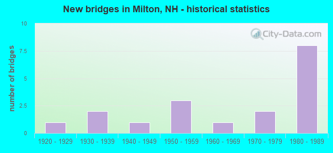
- New bridges - historical statistics
- 11920-1929
- 21930-1939
- 11940-1949
- 31950-1959
- 11960-1969
- 21970-1979
- 81980-1989

- Reconstructed bridges - Historical Statistics
- 11960-1969
- 11970-1979
- 01980-1989
- 21990-1999
- 12000-2009
- 12010-2019


- Bridge Condition - Deck
- 12.5%Very good
- 56.3%Good
- 25.0%Satisfactory
- 6.3%Failed

- Bridge Condition - Superstructure
- 12.5%Very good
- 62.5%Good
- 18.8%Satisfactory
- 6.3%Failed

- Bridge Condition - Substructure
- 18.8%Very good
- 56.3%Good
- 6.3%Satisfactory
- 12.5%Fair
- 6.3%Failed

- Bridge Condition - Channel
- 25.0%Very good
- 25.0%Good
- 50.0%Satisfactory

- Bridge Condition - Culverts
- 50.0%Good
- 50.0%Fair
Find on map >> Show street view
Structure Number: 27015800137, Location: 1.7 MI JCT I-89 (Lat: 43.154061, Lng: -71.507103), Route carried "on" structure: Interstate 93, Year Built: 1957, Year Reconstructed: 1978, Status: Open, Structure Length: 0.91m (2.99ft), Average Daily Traffic: 64,791 (year 2020), Truck Traffic: 9%, Average Future Daily Traffic: 95,890 (year 2042), Design Load: HS 20, Features Intersected: DOW ROAD
Minimum Vertical Clearance: 30+ m (98+ ft), Kilometerpoint: 56.052, Lanes on structure: 6, Lanes under structure: 2, Base Highway Network: Yes, Toll: On toll road, Owner: State Toll Authority, Approaching Roadway Width: 39.0m (128.0ft), Skew: 30 degrees, Material/Design: Concrete, Design/Construction: Culvert, Number Of Spans In Main Unit: 1, Length of Maximum Span: 9.1m (29.9ft)
Condition: Culverts: Fair, Operating Rating: 60.8 metric tons, Method Used To Determine Operating Rating: Load Factor (LF), Inventory Rating: 36.4 metric tons, Method Used To Determine Inventory Rating: Load Factor (LF), Structural Evaluation: Somewhat better than minimum adequacy, Underclear: High priority of replacement, Approach Roadway Alignment: Equal to present desirable criteria, Length Of Structure Improvement: 0.91m (2.99ft), Designated Inspection Frequency: Every 24 months, Inspection Date: April 2020, Bridge Improvement Cost: $2,718,000, Roadway Improvement Cost: $200,000, Total Project Cost: $3,142,000 ( Estimate for 2022)
Find on map >> Show street view
Structure Number: 173008100159, Location: NH.-ME. SL (Lat: 43.497914, Lng: -70.961564), Route carried "on" structure: Other road , Year Built: 1920, Year Reconstructed: 1998, Status: Open, Structure Length: 0.99m (3.25ft), Average Daily Traffic: 608 (year 2020), Truck Traffic: 4%, Average Future Daily Traffic: 899 (year 2042), Design Load: HS 25 or greater, Features Intersected: SALMON FALLS RIVER, Facility Carried by Structure: LEBANON STREET
Minimum Vertical Clearance: 30+ m (98+ ft), Kilometerpoint: 0.248, Lanes on structure: 2, Owner: City or Municipal Highway Agency, Approaching Roadway Width: 7.3m (24.0ft), Material/Design: Concrete, Design/Construction: Slab, Number Of Spans In Main Unit: 1, Length of Maximum Span: 8.2m (26.9ft), Curb-To-Curb Width: 7.5m (24.6ft), Out-to-Out Width: 9.9m (32.5ft)
Condition: Deck: Good, Superstructure: Good, Substructure: Fair, Channel: Satisfactory, Operating Rating: 70.4 metric tons, Method Used To Determine Operating Rating: Load Factor (LF), Inventory Rating: 42.3 metric tons, Method Used To Determine Inventory Rating: Load Factor (LF), Structural Evaluation: Somewhat better than minimum adequacy, Deck Geometry: Meets minimum limits, Waterway Adequacy: Better than present minimum criteria, Approach Roadway Alignment: Equal to present desirable criteria, Length Of Structure Improvement: 0.99m (3.25ft), Designated Inspection Frequency: Every 24 months, Inspection Date: August 2021, Bridge Improvement Cost: $2,718,000, Roadway Improvement Cost: $200,000, Total Project Cost: $3,142,000 ( Estimate for 2022), Deck Structure Type: Concrete Cast-file-Place, Wearing Surface/Protective System: Wearing Surface: Bituminous, Membrane: Preformed Fabric
Find on map >> Show street view
Structure Number: 173009800115, Location: 0.8 MI S. OF WAKEFIELD TL (Lat: 43.481942, Lng: -71.005492), Route carried "on" structure: State highway 16, Year Built: 1981, Status: Open, Structure Length: 5.01m (16.44ft), Average Daily Traffic: 12,708 (year 2020), Truck Traffic: 7%, Average Future Daily Traffic: 18,807 (year 2042), Design Load: HS 20+Mod, Features Intersected: BRANCH RIVER
Minimum Vertical Clearance: 30+ m (98+ ft), Kilometerpoint: 53.411, Lanes on structure: 3, Base Highway Network: Yes, Owner: State Toll Authority, Approaching Roadway Width: 15.2m (49.9ft), Material/Design: Steel continuous, Design/Construction: Stringer/Multi-beam, Number Of Spans In Main Unit: 2, Length of Maximum Span: 24.4m (80.1ft), Curb or Sidewalk Widths: Left: 0.2m (0.7ft), Right: 0.2m (0.7ft), Curb-To-Curb Width: 16.6m (54.5ft), Out-to-Out Width: 17.9m (58.7ft)
Condition: Deck: Good, Superstructure: Good, Substructure: Good, Channel: Satisfactory, Operating Rating: 48.2 metric tons, Method Used To Determine Operating Rating: Load Factor (LF), Inventory Rating: 28.9 metric tons, Method Used To Determine Inventory Rating: Load Factor (LF), Structural Evaluation: Better than present minimum criteria, Deck Geometry: Equal to present desirable criteria, Waterway Adequacy: Superior to present desirable criteria, Approach Roadway Alignment: Equal to present desirable criteria, Length Of Structure Improvement: 5.01m (16.44ft), Designated Inspection Frequency: Every 24 months, Inspection Date: June 2021, Bridge Improvement Cost: $2,718,000, Roadway Improvement Cost: $200,000, Total Project Cost: $3,142,000 ( Estimate for 2022), Deck Structure Type: Concrete Cast-file-Place, Wearing Surface/Protective System: Wearing Surface: Bituminous, Membrane: Other
Find on map >> Show street view
Structure Number: 17301010011, Location: 0.65 MI. S. WAKEFIELD TL (Lat: 43.481578, Lng: -71.010508), Route carried "on" structure: State highway , Year Built: 1932, Status: Open, Structure Length: 0.85m (2.79ft), Average Daily Traffic: 895 (year 2020), Truck Traffic: 4%, Average Future Daily Traffic: 1,324 (year 2042), Design Load: H 15, Features Intersected: JONES BROOK, Facility Carried by Structure: NH125
Minimum Vertical Clearance: 30+ m (98+ ft), Kilometerpoint: 81.236, Lanes on structure: 2, Owner: State Highway Agency, Approaching Roadway Width: 7.3m (24.0ft), Skew: 2 degrees, Material/Design: Concrete, Design/Construction: Frame, Number Of Spans In Main Unit: 1, Length of Maximum Span: 7.3m (24.0ft), Curb-To-Curb Width: 7.3m (24.0ft), Out-to-Out Width: 8.4m (27.6ft)
Condition: Deck: Good, Superstructure: Good, Substructure: Good, Channel: Satisfactory, Operating Rating: 41.5 metric tons, Method Used To Determine Operating Rating: Load Factor (LF), Inventory Rating: 24.8 metric tons, Method Used To Determine Inventory Rating: Load Factor (LF), Structural Evaluation: Equal to present minimum criteria, Deck Geometry: Meets minimum limits, Waterway Adequacy: Equal to present desirable criteria, Approach Roadway Alignment: Equal to present minimum criteria, Length Of Structure Improvement: 0.85m (2.79ft), Designated Inspection Frequency: Every 24 months, Inspection Date: June 2021, Bridge Improvement Cost: $2,718,000, Roadway Improvement Cost: $200,000, Total Project Cost: $3,142,000 ( Estimate for 2022), Deck Structure Type: Concrete Cast-file-Place, Wearing Surface/Protective System: Wearing Surface: Bituminous
Find on map >> Show street view
Structure Number: 17301020012, Location: 370' FROM INT OF NH 125 (Lat: 43.480392, Lng: -70.998808), Route carried "on" structure: State highway , Year Built: 1966, Status: Open, Structure Length: 3.93m (12.89ft), Average Daily Traffic: 2,346 (year 2020), Truck Traffic: 10%, Average Future Daily Traffic: 3,472 (year 2042), Design Load: HS 20, Features Intersected: BRANCH RIVER, Facility Carried by Structure: APPLEBEE ROAD
Minimum Vertical Clearance: 30+ m (98+ ft), Kilometerpoint: 0.119, Lanes on structure: 2, Owner: State Highway Agency, Approaching Roadway Width: 12.2m (40.0ft), Material/Design: Steel continuous, Design/Construction: Stringer/Multi-beam, Number Of Spans In Main Unit: 2, Length of Maximum Span: 18.9m (62.0ft), Curb or Sidewalk Widths: Left: 0.5m (1.6ft), Right: 0.5m (1.6ft), Curb-To-Curb Width: 13.4m (44.0ft), Out-to-Out Width: 15.2m (49.9ft)
Condition: Deck: Good, Superstructure: Good, Substructure: Good, Channel: Satisfactory, Operating Rating: 44.7 metric tons, Method Used To Determine Operating Rating: Field evaluation and documented engineering judgment, Inventory Rating: 32.7 metric tons, Method Used To Determine Inventory Rating: Field evaluation and documented engineering judgment, Structural Evaluation: Better than present minimum criteria, Deck Geometry: Better than present minimum criteria, Waterway Adequacy: Equal to present desirable criteria, Approach Roadway Alignment: Equal to present desirable criteria, Length Of Structure Improvement: 3.93m (12.89ft), Designated Inspection Frequency: Every 24 months, Inspection Date: June 2021, Bridge Improvement Cost: $2,718,000, Roadway Improvement Cost: $200,000, Total Project Cost: $3,142,000 ( Estimate for 2022), Deck Structure Type: Concrete Cast-file-Place, Wearing Surface/Protective System: Wearing Surface: Bituminous, Membrane: Other
Find on map >> Show street view
Structure Number: 173011400115, Location: 7.8 MI N OF ROCHESTER TL (Lat: 43.480683, Lng: -71.004947), Route carried "on" structure: State highway 16, Year Built: 1981, Status: Open, Structure Length: 3.51m (11.52ft), Average Daily Traffic: 13,135 (year 2020), Truck Traffic: 7%, Average Future Daily Traffic: 19,439 (year 2042), Design Load: HS 20+Mod, Features Intersected: NH125
Minimum Vertical Clearance: 30+ m (98+ ft), Kilometerpoint: 53.258, Lanes on structure: 4, Lanes under structure: 2, Base Highway Network: Yes, Owner: State Toll Authority, Approaching Roadway Width: 22.6m (74.1ft), Skew: 2 degrees, Material/Design: Steel, Design/Construction: Stringer/Multi-beam, Number Of Spans In Main Unit: 1, Length of Maximum Span: 33.5m (109.9ft), Curb or Sidewalk Widths: Left: 0.2m (0.7ft), Right: 0.2m (0.7ft), Curb-To-Curb Width: 23.0m (75.5ft), Out-to-Out Width: 24.2m (79.4ft)
Condition: Deck: Satisfactory, Superstructure: Good, Substructure: Good, Operating Rating: 44.5 metric tons, Method Used To Determine Operating Rating: Load Factor (LF), Inventory Rating: 32.7 metric tons, Method Used To Determine Inventory Rating: Load Factor (LF), Structural Evaluation: Better than present minimum criteria, Deck Geometry: Superior to present desirable criteria, Underclear: Superior to present desirable criteria, Approach Roadway Alignment: Equal to present desirable criteria, Length Of Structure Improvement: 3.51m (11.52ft), Designated Inspection Frequency: Every 24 months, Inspection Date: June 2021, Bridge Improvement Cost: $2,718,000, Roadway Improvement Cost: $200,000, Total Project Cost: $3,142,000 ( Estimate for 2022), Deck Structure Type: Concrete Cast-file-Place, Wearing Surface/Protective System: Wearing Surface: Bituminous, Membrane: Other
Find on map >> Show street view
Structure Number: 173012400116, Location: 6.6 MI N OF ROCHESTER TL (Lat: 43.464711, Lng: -70.997406), Route carried "on" structure: State highway 16, Year Built: 1980, Status: Open, Structure Length: 1.01m (3.31ft), Average Daily Traffic: 12,708 (year 2020), Truck Traffic: 7%, Average Future Daily Traffic: 18,807 (year 2042), Design Load: HS 20+Mod, Features Intersected: JONES ACCESS ROAD
Minimum Vertical Clearance: 30+ m (98+ ft), Kilometerpoint: 51.382, Lanes on structure: 2, Lanes under structure: 2, Base Highway Network: Yes, Owner: State Toll Authority, Approaching Roadway Width: 13.4m (44.0ft), Material/Design: Concrete, Design/Construction: Culvert, Number Of Spans In Main Unit: 1, Length of Maximum Span: 8.5m (27.9ft), Out-to-Out Width: 19.8m (65.0ft)
Condition: Culverts: Good, Operating Rating: 89.8 metric tons, Method Used To Determine Operating Rating: Load Factor (LF), Inventory Rating: 89.8 metric tons, Method Used To Determine Inventory Rating: Load Factor (LF), Structural Evaluation: Better than present minimum criteria, Underclear: High priority of replacement, Approach Roadway Alignment: Equal to present desirable criteria, Length Of Structure Improvement: 1.01m (3.31ft), Designated Inspection Frequency: Every 24 months, Inspection Date: June 2021, Bridge Improvement Cost: $2,718,000, Roadway Improvement Cost: $200,000, Total Project Cost: $3,142,000 ( Estimate for 2022), Deck Structure Type: Concrete Cast-file-Place
Find on map >> Show street view
Structure Number: 173014100122, Location: 5.7 MI N OF ROCHESTER TL (Lat: 43.451025, Lng: -70.995458), Route carried "on" structure: Other road 16, Year Built: 1980, Status: Open, Structure Length: 1.89m (6.20ft), Average Daily Traffic: 12,708 (year 2020), Truck Traffic: 7%, Average Future Daily Traffic: 18,807 (year 2042), Design Load: HS 20+Mod, Features Intersected: NHNCRR
Minimum Vertical Clearance: 30+ m (98+ ft), Kilometerpoint: 49.803, Lanes on structure: 2, Base Highway Network: Yes, Owner: State Toll Authority, Approaching Roadway Width: 13.4m (44.0ft), Skew: 4 degrees, Material/Design: Steel, Design/Construction: Stringer/Multi-beam, Number Of Spans In Main Unit: 1, Length of Maximum Span: 17.4m (57.1ft), Curb or Sidewalk Widths: Left: 0.2m (0.7ft), Right: 0.2m (0.7ft), Curb-To-Curb Width: 13.0m (42.7ft), Out-to-Out Width: 14.2m (46.6ft)
Condition: Deck: Good, Superstructure: Good, Substructure: Good, Operating Rating: 53.5 metric tons, Method Used To Determine Operating Rating: Load Factor (LF), Inventory Rating: 32.0 metric tons, Method Used To Determine Inventory Rating: Load Factor (LF), Structural Evaluation: Better than present minimum criteria, Deck Geometry: Somewhat better than minimum adequacy, Underclear: High priority of replacement, Approach Roadway Alignment: Equal to present desirable criteria, Length Of Structure Improvement: 1.89m (6.20ft), Designated Inspection Frequency: Every 24 months, Inspection Date: June 2021, Bridge Improvement Cost: $2,718,000, Roadway Improvement Cost: $200,000, Total Project Cost: $3,142,000 ( Estimate for 2022), Deck Structure Type: Concrete Cast-file-Place, Wearing Surface/Protective System: Wearing Surface: Bituminous, Membrane: Other
Find on map >> Show street view
Structure Number: 17301620011, Location: 4.6 MI N OF ROCHESTER TL (Lat: 43.438219, Lng: -71.006764), Route carried "on" structure: Other road 16, Year Built: 1980, Status: Open, Structure Length: 2.23m (7.32ft), Average Daily Traffic: 12,708 (year 2020), Truck Traffic: 7%, Average Future Daily Traffic: 18,807 (year 2042), Design Load: HS 20+Mod, Features Intersected: TENERIFFE ROAD
Minimum Vertical Clearance: 30+ m (98+ ft), Kilometerpoint: 48.098, Lanes on structure: 3, Lanes under structure: 2, Base Highway Network: Yes, Owner: State Toll Authority, Approaching Roadway Width: 15.2m (49.9ft), Skew: 1 degrees, Material/Design: Steel, Design/Construction: Stringer/Multi-beam, Number Of Spans In Main Unit: 1, Length of Maximum Span: 20.7m (67.9ft), Curb or Sidewalk Widths: Left: 0.2m (0.7ft), Right: 0.2m (0.7ft), Curb-To-Curb Width: 14.8m (48.6ft), Out-to-Out Width: 16.1m (52.8ft)
Condition: Deck: Satisfactory, Superstructure: Satisfactory, Substructure: Good, Operating Rating: 54.2 metric tons, Method Used To Determine Operating Rating: Load Factor (LF), Inventory Rating: 32.5 metric tons, Method Used To Determine Inventory Rating: Load Factor (LF), Structural Evaluation: Equal to present minimum criteria, Deck Geometry: Equal to present minimum criteria, Underclear: Meets minimum limits, Approach Roadway Alignment: Equal to present desirable criteria, Length Of Structure Improvement: 2.23m (7.32ft), Designated Inspection Frequency: Every 24 months, Inspection Date: June 2021, Bridge Improvement Cost: $2,718,000, Roadway Improvement Cost: $200,000, Total Project Cost: $3,142,000 ( Estimate for 2022), Deck Structure Type: Concrete Cast-file-Place, Wearing Surface/Protective System: Wearing Surface: Bituminous, Membrane: Other
Find on map >> Show street view
Structure Number: 173016800152, Location: NH-ME SL (Lat: 43.435461, Lng: -70.966611), Route carried "on" structure: Other road , Year Built: 1948, Status: Closed, Structure Length: 2.87m (9.42ft), Average Daily Traffic: 452 (year 2020), Truck Traffic: 4%, Average Future Daily Traffic: 668 (year 2042), Design Load: H 15, Features Intersected: NORTHEAST POND, Facility Carried by Structure: TOWNHOUSE ROAD
Minimum Vertical Clearance: 30+ m (98+ ft), Kilometerpoint: 1.773, Lanes on structure: 2, Owner: City or Municipal Highway Agency, Approaching Roadway Width: 5.2m (17.1ft), Material/Design: Wood or Timber, Design/Construction: Stringer/Multi-beam, Number Of Spans In Main Unit: 4, Length of Maximum Span: 6.7m (22.0ft), Curb or Sidewalk Widths: Left: 0.2m (0.7ft), Right: 1.2m (3.9ft), Curb-To-Curb Width: 6.1m (20.0ft), Out-to-Out Width: 8.0m (26.2ft)
Condition: Deck: Failed, Superstructure: Failed, Substructure: Failed, Channel: Very good, Deck Geometry: High priority of corrective action, Waterway Adequacy: Superior to present desirable criteria, Approach Roadway Alignment: Equal to present minimum criteria, Bridge Posting: Required (Relationship of Operating Rating to Maximum Legal Load: > 39.9% below), Length Of Structure Improvement: 2.87m (9.42ft), Designated Inspection Frequency: Every 16 months, Inspection Date: August 2021, Bridge Improvement Cost: $2,718,000, Roadway Improvement Cost: $200,000, Total Project Cost: $3,142,000 ( Estimate for 2022), Deck Structure Type: Wood or Timber, Wearing Surface/Protective System: Wearing Surface: Wood or Timber
Find on map >> Show street view
Structure Number: 173018700109, Location: 3.5 MI N OF ROCHESTER TL (Lat: 43.422736, Lng: -71.009275), Route carried "on" structure: Other road 16, Year Built: 1980, Status: Open, Structure Length: 2.80m (9.19ft), Average Daily Traffic: 12,708 (year 2020), Truck Traffic: 7%, Average Future Daily Traffic: 18,807 (year 2042), Design Load: HS 20+Mod, Features Intersected: SILVER STREET
Minimum Vertical Clearance: 30+ m (98+ ft), Kilometerpoint: 46.351, Lanes on structure: 3, Lanes under structure: 2, Base Highway Network: Yes, Owner: State Toll Authority, Approaching Roadway Width: 15.2m (49.9ft), Skew: 4 degrees, Material/Design: Steel, Design/Construction: Stringer/Multi-beam, Number Of Spans In Main Unit: 1, Length of Maximum Span: 26.5m (86.9ft), Curb or Sidewalk Widths: Left: 0.2m (0.7ft), Right: 0.2m (0.7ft), Curb-To-Curb Width: 14.8m (48.6ft), Out-to-Out Width: 16.1m (52.8ft)
Condition: Deck: Good, Superstructure: Good, Substructure: Very good, Operating Rating: 53.4 metric tons, Method Used To Determine Operating Rating: Load Factor (LF), Inventory Rating: 32.0 metric tons, Method Used To Determine Inventory Rating: Load Factor (LF), Structural Evaluation: Better than present minimum criteria, Deck Geometry: Equal to present minimum criteria, Underclear: Meets minimum limits, Approach Roadway Alignment: Equal to present desirable criteria, Length Of Structure Improvement: 2.80m (9.19ft), Designated Inspection Frequency: Every 24 months, Inspection Date: June 2021, Bridge Improvement Cost: $2,718,000, Roadway Improvement Cost: $200,000, Total Project Cost: $3,142,000 ( Estimate for 2022), Deck Structure Type: Concrete Cast-file-Place, Wearing Surface/Protective System: Wearing Surface: Bituminous, Membrane: Other
Find on map >> Show street view
Structure Number: 173019800131, Location: NH-ME SL (Lat: 43.413828, Lng: -70.986983), Route carried "on" structure: Other road , Year Built: 1950, Year Reconstructed: 2004, Status: Open, Structure Length: 3.17m (10.40ft), Average Daily Traffic: 2,061 (year 2020), Truck Traffic: 7%, Average Future Daily Traffic: 3,050 (year 2042), Features Intersected: SALMON FALLS RIVER, Facility Carried by Structure: GARAGE WAY
Minimum Vertical Clearance: 30+ m (98+ ft), Kilometerpoint: 0.048, Lanes on structure: 2, Owner: City or Municipal Highway Agency, Approaching Roadway Width: 5.8m (19.0ft), Material/Design: Prestressed concrete, Design/Construction: Slab, Number Of Spans In Main Unit: 2, Length of Maximum Span: 12.2m (40.0ft), Curb-To-Curb Width: 6.9m (22.6ft), Out-to-Out Width: 7.9m (25.9ft)
Condition: Deck: Very good, Superstructure: Very good, Substructure: Fair, Channel: Good, Operating Rating: 64.8 metric tons, Method Used To Determine Operating Rating: Load Factor (LF), Inventory Rating: 40.5 metric tons, Method Used To Determine Inventory Rating: Load Factor (LF), Structural Evaluation: Somewhat better than minimum adequacy, Deck Geometry: High priority of replacement, Waterway Adequacy: Better than present minimum criteria, Approach Roadway Alignment: Equal to present desirable criteria, Length Of Structure Improvement: 3.17m (10.40ft), Designated Inspection Frequency: Every 24 months, Underwater Inspection Frequency: Every 60 months, Inspection Date: August 2021, Underwater Inspection Date: July 2018, Bridge Improvement Cost: $2,718,000, Roadway Improvement Cost: $200,000, Total Project Cost: $3,142,000 ( Estimate for 2022), Deck Structure Type: Concrete Cast-file-Place, Wearing Surface/Protective System: Wearing Surface: Bituminous, Membrane: Preformed Fabric
Find on map >> Show street view
Structure Number: 173021200128, Location: 1.9 MI FROM ROCHESTER TL (Lat: 43.404228, Lng: -70.989167), Route carried "on" structure: State highway 16, Year Built: 1954, Year Reconstructed: 2011, Status: Open, Structure Length: 4.60m (15.09ft), Average Daily Traffic: 6,495 (year 2020), Truck Traffic: 7%, Average Future Daily Traffic: 9,612 (year 2042), Design Load: HL 93, Features Intersected: NHNCRR, Facility Carried by Structure: NH125
Minimum Vertical Clearance: 30+ m (98+ ft), Kilometerpoint: 71.448, Lanes on structure: 2, Owner: State Highway Agency, Approaching Roadway Width: 10.4m (34.1ft), Skew: 5 degrees, Material/Design: Steel continuous, Design/Construction: Stringer/Multi-beam, Number Of Spans In Main Unit: 3, Length of Maximum Span: 16.5m (54.1ft), Curb or Sidewalk Widths: Left: 0.2m (0.7ft), Right: 0.2m (0.7ft), Curb-To-Curb Width: 9.3m (30.5ft), Out-to-Out Width: 10.5m (34.4ft)
Condition: Deck: Very good, Superstructure: Very good, Substructure: Very good, Operating Rating: 69.9 metric tons, Method Used To Determine Operating Rating: Load Factor (LF), Inventory Rating: 41.8 metric tons, Method Used To Determine Inventory Rating: Load Factor (LF), Structural Evaluation: Equal to present desirable criteria, Deck Geometry: High priority of corrective action, Underclear: High priority of replacement, Approach Roadway Alignment: Equal to present desirable criteria, Length Of Structure Improvement: 4.60m (15.09ft), Designated Inspection Frequency: Every 24 months, Inspection Date: June 2021, Bridge Improvement Cost: $2,718,000, Roadway Improvement Cost: $200,000, Total Project Cost: $3,142,000 ( Estimate for 2022), Deck Structure Type: Concrete Cast-file-Place, Wearing Surface/Protective System: Wearing Surface: Bituminous, Membrane: Preformed Fabric, Deck Protection: Epoxy Coated Reinforcing
Find on map >> Show street view
Structure Number: 173021600112, Location: 2.1 MI N OF ROCHESTER TL (Lat: 43.402483, Lng: -71.005339), Route carried "on" structure: Other road 16, Year Built: 1980, Year Reconstructed: 2016, Status: Open, Structure Length: 4.27m (14.01ft), Average Daily Traffic: 12,708 (year 2020), Truck Traffic: 7%, Average Future Daily Traffic: 18,807 (year 2042), Design Load: HS 20+Mod, Features Intersected: NH 75
Minimum Vertical Clearance: 30+ m (98+ ft), Kilometerpoint: 44.069, Lanes on structure: 2, Lanes under structure: 2, Base Highway Network: Yes, Owner: State Toll Authority, Approaching Roadway Width: 12.8m (42.0ft), Skew: 4 degrees, Material/Design: Steel, Design/Construction: Stringer/Multi-beam, Number Of Spans In Main Unit: 1, Length of Maximum Span: 41.1m (134.8ft), Curb or Sidewalk Widths: Left: 0.3m (1.0ft), Right: 0.3m (1.0ft), Curb-To-Curb Width: 13.0m (42.7ft), Out-to-Out Width: 14.2m (46.6ft)
Condition: Deck: Good, Superstructure: Good, Substructure: Good, Operating Rating: 54.1 metric tons, Method Used To Determine Operating Rating: Load Factor (LF), Inventory Rating: 32.5 metric tons, Method Used To Determine Inventory Rating: Load Factor (LF), Structural Evaluation: Better than present minimum criteria, Deck Geometry: Somewhat better than minimum adequacy, Underclear: Better than present minimum criteria, Approach Roadway Alignment: Equal to present desirable criteria, Length Of Structure Improvement: 4.27m (14.01ft), Designated Inspection Frequency: Every 24 months, Inspection Date: June 2021, Bridge Improvement Cost: $2,718,000, Roadway Improvement Cost: $200,000, Total Project Cost: $3,142,000 ( Estimate for 2022), Deck Structure Type: Concrete Cast-file-Place, Wearing Surface/Protective System: Wearing Surface: Bituminous, Membrane: Other
Find on map >> Show street view
Structure Number: 173021900112, Location: 1.8 MI N OF ROCHESTER TL (Lat: 43.398114, Lng: -71.003558), Route carried "on" structure: State highway 16, Year Built: 1980, Status: Open, Structure Length: 9.51m (31.20ft), Average Daily Traffic: 14,399 (year 2020), Truck Traffic: 7%, Average Future Daily Traffic: 21,310 (year 2042), Design Load: HS 20+Mod, Features Intersected: LYMAN BROOK
Minimum Vertical Clearance: 30+ m (98+ ft), Kilometerpoint: 43.573, Lanes on structure: 2, Base Highway Network: Yes, Owner: State Toll Authority, Approaching Roadway Width: 12.8m (42.0ft), Skew: 6 degrees, Material/Design: Steel continuous, Design/Construction: Stringer/Multi-beam, Number Of Spans In Main Unit: 3, Length of Maximum Span: 36.6m (120.1ft), Curb or Sidewalk Widths: Left: 0.2m (0.7ft), Right: 0.2m (0.7ft), Curb-To-Curb Width: 13.0m (42.7ft), Out-to-Out Width: 15.8m (51.8ft)
Condition: Deck: Good, Superstructure: Good, Substructure: Very good, Channel: Very good, Operating Rating: 50.9 metric tons, Method Used To Determine Operating Rating: Load Factor (LF), Inventory Rating: 30.5 metric tons, Method Used To Determine Inventory Rating: Load Factor (LF), Structural Evaluation: Better than present minimum criteria, Deck Geometry: Somewhat better than minimum adequacy, Waterway Adequacy: Superior to present desirable criteria, Approach Roadway Alignment: Equal to present desirable criteria, Length Of Structure Improvement: 9.51m (31.20ft), Designated Inspection Frequency: Every 24 months, Inspection Date: June 2021, Bridge Improvement Cost: $2,718,000, Roadway Improvement Cost: $200,000, Total Project Cost: $3,142,000 ( Estimate for 2022), Deck Structure Type: Concrete Cast-file-Place, Wearing Surface/Protective System: Wearing Surface: Bituminous, Membrane: Other
Find on map >> Show street view
Structure Number: 173021900124, Location: 2.7 MI N OF FARMINGTON TL (Lat: 43.396514, Lng: -70.994097), Route carried "on" structure: State highway 75, Year Built: 1978, Status: Open, Structure Length: 2.13m (6.99ft), Average Daily Traffic: 3,072 (year 2020), Truck Traffic: 4%, Average Future Daily Traffic: 4,546 (year 2042), Design Load: HS 20+Mod, Features Intersected: NHNCRR
Minimum Vertical Clearance: 30+ m (98+ ft), Kilometerpoint: 8.425, Lanes on structure: 2, Owner: State Toll Authority, Approaching Roadway Width: 11.6m (38.1ft), Material/Design: Steel, Design/Construction: Stringer/Multi-beam, Number Of Spans In Main Unit: 1, Length of Maximum Span: 19.8m (65.0ft), Curb or Sidewalk Widths: Left: 0.2m (0.7ft), Right: 0.2m (0.7ft), Curb-To-Curb Width: 13.0m (42.7ft), Out-to-Out Width: 14.2m (46.6ft)
Condition: Deck: Satisfactory, Superstructure: Satisfactory, Substructure: Good, Operating Rating: 53.4 metric tons, Method Used To Determine Operating Rating: Load Factor (LF), Inventory Rating: 32.0 metric tons, Method Used To Determine Inventory Rating: Load Factor (LF), Structural Evaluation: Equal to present minimum criteria, Deck Geometry: Equal to present minimum criteria, Underclear: High priority of replacement, Approach Roadway Alignment: Equal to present desirable criteria, Length Of Structure Improvement: 2.13m (6.99ft), Designated Inspection Frequency: Every 24 months, Inspection Date: June 2021, Bridge Improvement Cost: $2,718,000, Roadway Improvement Cost: $200,000, Total Project Cost: $3,142,000 ( Estimate for 2022), Deck Structure Type: Concrete Cast-file-Place, Wearing Surface/Protective System: Wearing Surface: Bituminous, Membrane: Other
Find on map >> Show street view
Structure Number: 173022900125, Location: 1.0 MI ROCHESTER TL (Lat: 43.390744, Lng: -70.990725), Route carried "on" structure: State highway 16, Year Built: 1935, Year Reconstructed: 1973, Status: Open, Structure Length: 0.85m (2.79ft), Average Daily Traffic: 4,422 (year 2020), Truck Traffic: 7%, Average Future Daily Traffic: 6,544 (year 2042), Design Load: H 15, Features Intersected: LYMAN BROOK, Facility Carried by Structure: NH125
Minimum Vertical Clearance: 30+ m (98+ ft), Kilometerpoint: 69.924, Lanes on structure: 2, Owner: State Highway Agency, Approaching Roadway Width: 9.1m (29.9ft), Skew: 3 degrees, Material/Design: Concrete, Design/Construction: Slab, Number Of Spans In Main Unit: 1, Length of Maximum Span: 7.0m (23.0ft), Curb or Sidewalk Widths: Left: 0.3m (1.0ft), Right: 0.3m (1.0ft), Curb-To-Curb Width: 10.5m (34.4ft), Out-to-Out Width: 11.0m (36.1ft)
Condition: Deck: Satisfactory, Superstructure: Satisfactory, Substructure: Satisfactory, Channel: Good, Operating Rating: 82.0 metric tons, Method Used To Determine Operating Rating: Load Factor (LF), Inventory Rating: 58.6 metric tons, Method Used To Determine Inventory Rating: Load Factor (LF), Structural Evaluation: Equal to present minimum criteria, Deck Geometry: Somewhat better than minimum adequacy, Waterway Adequacy: Equal to present desirable criteria, Approach Roadway Alignment: Equal to present desirable criteria, Length Of Structure Improvement: 0.85m (2.79ft), Designated Inspection Frequency: Every 24 months, Inspection Date: June 2021, Bridge Improvement Cost: $2,718,000, Roadway Improvement Cost: $200,000, Total Project Cost: $3,142,000 ( Estimate for 2022), Deck Structure Type: Concrete Cast-file-Place, Wearing Surface/Protective System: Wearing Surface: Bituminous
Find on map >> Show street view
Structure Number: 173023700126, Location: 0.9 MI N OF ROCHESTER TL (Lat: 43.385533, Lng: -70.998083), Route carried "on" structure: Other road 16, Year Built: 1978, Status: Open, Structure Length: 2.19m (7.19ft), Average Daily Traffic: 14,399 (year 2020), Truck Traffic: 7%, Average Future Daily Traffic: 21,310 (year 2042), Design Load: HS 20+Mod, Features Intersected: MCKEAGHNEY ROAD
Minimum Vertical Clearance: 30+ m (98+ ft), Kilometerpoint: 42.092, Lanes on structure: 2, Lanes under structure: 2, Base Highway Network: Yes, Owner: State Toll Authority, Approaching Roadway Width: 13.1m (43.0ft), Material/Design: Steel, Design/Construction: Stringer/Multi-beam, Number Of Spans In Main Unit: 1, Length of Maximum Span: 19.8m (65.0ft), Curb or Sidewalk Widths: Left: 0.2m (0.7ft), Right: 0.2m (0.7ft), Curb-To-Curb Width: 13.0m (42.7ft), Out-to-Out Width: 14.2m (46.6ft)
Condition: Deck: Good, Superstructure: Good, Substructure: Good, Operating Rating: 52.4 metric tons, Method Used To Determine Operating Rating: Load Factor (LF), Inventory Rating: 31.4 metric tons, Method Used To Determine Inventory Rating: Load Factor (LF), Structural Evaluation: Better than present minimum criteria, Deck Geometry: Somewhat better than minimum adequacy, Underclear: Equal to present minimum criteria, Approach Roadway Alignment: Equal to present desirable criteria, Length Of Structure Improvement: 2.19m (7.19ft), Designated Inspection Frequency: Every 24 months, Inspection Date: June 2021, Bridge Improvement Cost: $2,718,000, Roadway Improvement Cost: $200,000, Total Project Cost: $3,142,000 ( Estimate for 2022), Deck Structure Type: Concrete Cast-file-Place, Wearing Surface/Protective System: Wearing Surface: Bituminous, Membrane: Other