Bridge Statistics for Mina, New York (NY)
Condition, Traffic, Stress, Structural Evaluation, Project Costs
- National Bridge Inventory (NBI) Statistics
- 23Number of bridges
- 220ft / 66.6mTotal length
- $54,191,000Total costs
- 55,682Total average daily traffic
- 7,912Total average daily truck traffic
- National Bridge Inventory (NBI) Registered Bridges for Mina
- No street view available for this location
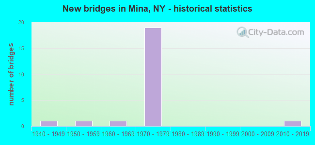
- New bridges - historical statistics
- 11940-1949
- 11950-1959
- 11960-1969
- 191970-1979
- 12010-2019


- Bridge Condition - Deck
- 23.1%Very good
- 53.8%Good
- 7.7%Satisfactory
- 15.4%Fair

- Bridge Condition - Superstructure
- 61.5%Very good
- 30.8%Good
- 7.7%Satisfactory

- Bridge Condition - Substructure
- 38.5%Very good
- 38.5%Good
- 23.1%Fair

- Bridge Condition - Channel
- 20.0%Very good
- 40.0%Good
- 40.0%Fair
Find on map >> Show street view
Structure Number: 104838, Location: .2 MILE N EXIT 4 OF I86 (Lat: 42.132192, Lng: -79.742006), Route carried "on" structure: State highway 426, Year Built: 1947, Year Reconstructed: 1999, Status: Open, Structure Length: 1.89m (6.20ft), Average Daily Traffic: 617 (year 2020), Truck Traffic: 6%, Average Future Daily Traffic: 623 (year 2040), Design Load: HS 25 or greater, Features Intersected: W BR FRENCH CREEK
Minimum Vertical Clearance: 30+ m (98+ ft), Kilometerpoint: 18.600, Lanes on structure: 2, Base Highway Network: Yes, Owner: State Highway Agency, Approaching Roadway Width: 9.4m (30.8ft), Material/Design: Steel, Design/Construction: Stringer/Multi-beam, Number Of Spans In Main Unit: 1, Length of Maximum Span: 17.6m (57.7ft), Curb-To-Curb Width: 11.0m (36.1ft), Out-to-Out Width: 11.6m (38.1ft)
Condition: Deck: Very good, Superstructure: Very good, Substructure: Good, Channel: Very good, Operating Rating: 76.2 metric tons, Method Used To Determine Operating Rating: Load Factor (LF), Inventory Rating: 45.4 metric tons, Method Used To Determine Inventory Rating: Load Factor (LF), Structural Evaluation: Better than present minimum criteria, Deck Geometry: Better than present minimum criteria, Waterway Adequacy: Somewhat better than minimum adequacy, Approach Roadway Alignment: Equal to present desirable criteria, Length Of Structure Improvement: 1.88m (6.17ft), Designated Inspection Frequency: Every 24 months, Inspection Date: September 2021, Bridge Improvement Cost: $1,323,000, Roadway Improvement Cost: $775,000, Total Project Cost: $2,098,000 ( Estimate for 2021), Deck Structure Type: Concrete Cast-file-Place, Wearing Surface/Protective System: Wearing Surface: Monolithic Concrete, Deck Protection: Epoxy Coated Reinforcing
Find on map >> Show street view
Structure Number: 109171, Location: .8 MI W JCT SH 426 & I86 (Lat: 42.129469, Lng: -79.756067), Route carried "on" structure: Other road , Year Built: 1973, Status: Open, Structure Length: 12.10m (39.70ft), Average Daily Traffic: 109 (year 2019), Truck Traffic: 5%, Average Future Daily Traffic: 153 (year 2039), Design Load: HS 20, Features Intersected: 86I 17 52111003 WB, RTE, Facility Carried by Structure: GREENMAN ROAD
Minimum Vertical Clearance: 30+ m (98+ ft), Kilometerpoint: 1.142, Lanes on structure: 2, Lanes under structure: 4, Owner: State Highway Agency, Approaching Roadway Width: 10.4m (34.1ft), Material/Design: Steel, Design/Construction: Stringer/Multi-beam, Number Of Spans In Main Unit: 3, Length of Maximum Span: 39.6m (129.9ft), Curb-To-Curb Width: 10.1m (33.1ft), Out-to-Out Width: 11.0m (36.1ft)
Condition: Deck: Good, Superstructure: Good, Substructure: Good, Operating Rating: 53.8 metric tons, Method Used To Determine Operating Rating: Load and Resistance Factor Rating (LRFR) rating reported by rating factor(RF) method using HL-93 loadings, Inventory Rating: 41.5 metric tons, Method Used To Determine Inventory Rating: Load and Resistance Factor Rating (LRFR) rating reported by rating factor(RF) method using HL-93 loadings, Structural Evaluation: Better than present minimum criteria, Deck Geometry: Better than present minimum criteria, Underclear: Meets minimum limits, Approach Roadway Alignment: Equal to present desirable criteria, Length Of Structure Improvement: 12.10m (39.70ft), Designated Inspection Frequency: Every 24 months, Inspection Date: September 2021, Bridge Improvement Cost: $4,917,000, Roadway Improvement Cost: $2,879,000, Total Project Cost: $7,797,000 ( Estimate for 2021), Deck Structure Type: Concrete Cast-file-Place, Wearing Surface/Protective System: Wearing Surface: Integral Concrete
Find on map >> Show street view
Structure Number: 1091721, Location: JCT SH 426 & S.T.E. - I86 (Lat: 42.130956, Lng: -79.741725), Route carried "on" structure: Interstate 86, Year Built: 1973, Status: Open, Structure Length: 3.96m (12.99ft), Average Daily Traffic: 4,118 (year 2014), Truck Traffic: 20%, Design Load: HS 20, Features Intersected: RTE 426
Minimum Vertical Clearance: 30+ m (98+ ft), Kilometerpoint: 1.689, Lanes on structure: 2, Lanes under structure: 3, Base Highway Network: Yes, Owner: State Highway Agency, Approaching Roadway Width: 12.8m (42.0ft), Material/Design: Steel, Design/Construction: Stringer/Multi-beam, Number Of Spans In Main Unit: 1, Length of Maximum Span: 38.1m (125.0ft), Curb-To-Curb Width: 12.6m (41.3ft), Out-to-Out Width: 13.6m (44.6ft)
Condition: Deck: Very good, Superstructure: Very good, Substructure: Very good, Operating Rating: 61.7 metric tons, Method Used To Determine Operating Rating: Load Factor (LF), Inventory Rating: 36.3 metric tons, Method Used To Determine Inventory Rating: Load Factor (LF), Structural Evaluation: Equal to present desirable criteria, Deck Geometry: Better than present minimum criteria, Underclear: Somewhat better than minimum adequacy, Approach Roadway Alignment: Equal to present desirable criteria, Length Of Structure Improvement: 3.96m (12.99ft), Designated Inspection Frequency: Every 24 months, Inspection Date: October 2021, Bridge Improvement Cost: $2,427,000, Roadway Improvement Cost: $1,421,000, Total Project Cost: $3,848,000 ( Estimate for 2021), Deck Structure Type: Concrete Cast-file-Place, Wearing Surface/Protective System: Wearing Surface: Integral Concrete
Find on map >> Show street view
Structure Number: 1091722, Location: JCT SH 426 & S.T.E. - I86 (Lat: 42.130306, Lng: -79.741564), Route carried "on" structure: Interstate 86, Year Built: 1973, Status: Open, Structure Length: 3.96m (12.99ft), Average Daily Traffic: 4,009 (year 2020), Truck Traffic: 20%, Average Future Daily Traffic: 4,774 (year 2040), Design Load: HS 20, Features Intersected: RTE 426
Minimum Vertical Clearance: 30+ m (98+ ft), Kilometerpoint: 1.673, Lanes on structure: 2, Lanes under structure: 3, Base Highway Network: Yes, Owner: State Highway Agency, Approaching Roadway Width: 13.7m (44.9ft), Material/Design: Steel, Design/Construction: Stringer/Multi-beam, Number Of Spans In Main Unit: 1, Length of Maximum Span: 38.1m (125.0ft), Curb-To-Curb Width: 12.6m (41.3ft), Out-to-Out Width: 13.6m (44.6ft)
Condition: Deck: Good, Superstructure: Very good, Substructure: Very good, Operating Rating: 55.7 metric tons, Method Used To Determine Operating Rating: Load and Resistance Factor Rating (LRFR) rating reported by rating factor(RF) method using HL-93 loadings, Inventory Rating: 42.8 metric tons, Method Used To Determine Inventory Rating: Load and Resistance Factor Rating (LRFR) rating reported by rating factor(RF) method using HL-93 loadings, Structural Evaluation: Equal to present desirable criteria, Deck Geometry: Better than present minimum criteria, Underclear: Somewhat better than minimum adequacy, Approach Roadway Alignment: Equal to present desirable criteria, Length Of Structure Improvement: 3.96m (12.99ft), Designated Inspection Frequency: Every 24 months, Inspection Date: October 2021, Bridge Improvement Cost: $2,427,000, Roadway Improvement Cost: $1,421,000, Total Project Cost: $3,848,000 ( Estimate for 2021), Deck Structure Type: Concrete Cast-file-Place, Wearing Surface/Protective System: Wearing Surface: Integral Concrete
Find on map >> Show street view
Structure Number: 109173, Location: 0.1 MI E JCT RTE 426+ STE (Lat: 42.130742, Lng: -79.739933), Route carried "on" structure: Interstate 86, Year Built: 1973, Status: Open, Structure Length: 0.85m (2.79ft), Average Daily Traffic: 6,578 (year 2020), Truck Traffic: 32%, Average Future Daily Traffic: 7,834 (year 2040), Design Load: H 20, Features Intersected: W BR FRENCH CREEK
Minimum Vertical Clearance: 30+ m (98+ ft), Kilometerpoint: 1.818, Lanes on structure: 6, Base Highway Network: Yes, Owner: State Highway Agency, Approaching Roadway Width: 25.0m (82.0ft), Skew: 21 degrees, Material/Design: Steel, Design/Construction: Culvert, Number Of Spans In Main Unit: 2, Length of Maximum Span: 3.6m (11.8ft)
Condition: Channel: Good, Culverts: Satisfactory, Operating Rating: 72.5 metric tons, Method Used To Determine Operating Rating: Field evaluation and documented engineering judgment, Inventory Rating: 32.7 metric tons, Method Used To Determine Inventory Rating: Field evaluation and documented engineering judgment, Structural Evaluation: Equal to present minimum criteria, Waterway Adequacy: High priority of replacement, Approach Roadway Alignment: Equal to present desirable criteria, Length Of Structure Improvement: 0.85m (2.79ft), Designated Inspection Frequency: Every 24 months, Inspection Date: November 2021, Bridge Improvement Cost: $589,000, Roadway Improvement Cost: $345,000, Total Project Cost: $934,000 ( Estimate for 2021), Wearing Surface/Protective System: Wearing Surface: Monolithic Concrete
Find on map >> Show street view
Structure Number: 109174, Location: 3.0 MI NE JCT 426 + S.T.E (Lat: 42.138264, Lng: -79.725917), Route carried "on" structure: County highway , Year Built: 1973, Status: Open, Structure Length: 11.49m (37.70ft), Average Daily Traffic: 177 (year 2018), Truck Traffic: 13%, Average Future Daily Traffic: 248 (year 2038), Design Load: HS 20, Features Intersected: 86I 17 52111019 WB, RTE, Facility Carried by Structure: COUNTY ROAD 3
Minimum Vertical Clearance: 30+ m (98+ ft), Kilometerpoint: 2.253, Lanes on structure: 2, Lanes under structure: 4, Owner: State Highway Agency, Approaching Roadway Width: 10.4m (34.1ft), Skew: 4 degrees, Material/Design: Steel, Design/Construction: Stringer/Multi-beam, Number Of Spans In Main Unit: 3, Length of Maximum Span: 39.3m (128.9ft), Curb-To-Curb Width: 10.1m (33.1ft), Out-to-Out Width: 11.0m (36.1ft)
Condition: Deck: Fair, Superstructure: Very good, Substructure: Good, Operating Rating: 58.1 metric tons, Method Used To Determine Operating Rating: Load Factor (LF), Inventory Rating: 34.5 metric tons, Method Used To Determine Inventory Rating: Load Factor (LF), Structural Evaluation: Better than present minimum criteria, Deck Geometry: Better than present minimum criteria, Underclear: High priority of corrective action, Approach Roadway Alignment: Equal to present desirable criteria, Length Of Structure Improvement: 11.49m (37.70ft), Designated Inspection Frequency: Every 24 months, Inspection Date: May 2021, Bridge Improvement Cost: $4,927,000, Roadway Improvement Cost: $2,885,000, Total Project Cost: $7,812,000 ( Estimate for 2021), Deck Structure Type: Concrete Cast-file-Place, Wearing Surface/Protective System: Wearing Surface: Bituminous
Find on map >> Show street view
Structure Number: 1091751, Location: 3.0 MI W JCT 430 + S.T.E. (Lat: 42.143853, Lng: -79.673897), Route carried "on" structure: Interstate 86, Year Built: 1973, Status: Open, Structure Length: 3.05m (10.01ft), Average Daily Traffic: 3,619 (year 2014), Truck Traffic: 27%, Design Load: HS 20, Features Intersected: CAMP ROAD/CR 13
Minimum Vertical Clearance: 30+ m (98+ ft), Kilometerpoint: 7.788, Lanes on structure: 2, Lanes under structure: 2, Base Highway Network: Yes, Owner: State Highway Agency, Approaching Roadway Width: 12.8m (42.0ft), Skew: 2 degrees, Material/Design: Steel, Design/Construction: Stringer/Multi-beam, Number Of Spans In Main Unit: 1, Length of Maximum Span: 28.9m (94.8ft), Curb-To-Curb Width: 12.6m (41.3ft), Out-to-Out Width: 13.5m (44.3ft)
Condition: Deck: Good, Superstructure: Very good, Substructure: Good, Operating Rating: 54.8 metric tons, Method Used To Determine Operating Rating: Load and Resistance Factor Rating (LRFR) rating reported by rating factor(RF) method using HL-93 loadings, Inventory Rating: 42.1 metric tons, Method Used To Determine Inventory Rating: Load and Resistance Factor Rating (LRFR) rating reported by rating factor(RF) method using HL-93 loadings, Structural Evaluation: Better than present minimum criteria, Deck Geometry: Better than present minimum criteria, Underclear: Somewhat better than minimum adequacy, Approach Roadway Alignment: Equal to present desirable criteria, Length Of Structure Improvement: 3.04m (9.97ft), Designated Inspection Frequency: Every 24 months, Inspection Date: September 2021, Bridge Improvement Cost: $1,947,000, Roadway Improvement Cost: $1,140,000, Total Project Cost: $3,087,000 ( Estimate for 2021), Deck Structure Type: Concrete Cast-file-Place, Wearing Surface/Protective System: Wearing Surface: Monolithic Concrete
Find on map >> Show street view
Structure Number: 1091752, Location: 3.0 MI W JCT 430 + S.T.E. (Lat: 42.143167, Lng: -79.673897), Route carried "on" structure: Interstate 86, Year Built: 1973, Status: Open, Structure Length: 3.05m (10.01ft), Average Daily Traffic: 3,289 (year 2020), Truck Traffic: 32%, Average Future Daily Traffic: 3,917 (year 2040), Design Load: HS 20, Features Intersected: CAMP ROAD/CR 13
Minimum Vertical Clearance: 30+ m (98+ ft), Kilometerpoint: 7.771, Lanes on structure: 2, Lanes under structure: 2, Base Highway Network: Yes, Owner: State Highway Agency, Approaching Roadway Width: 12.8m (42.0ft), Skew: 2 degrees, Material/Design: Steel, Design/Construction: Stringer/Multi-beam, Number Of Spans In Main Unit: 1, Length of Maximum Span: 28.9m (94.8ft), Curb-To-Curb Width: 12.6m (41.3ft), Out-to-Out Width: 13.5m (44.3ft)
Condition: Deck: Satisfactory, Superstructure: Good, Substructure: Good, Operating Rating: 70.8 metric tons, Method Used To Determine Operating Rating: Load Factor (LF), Inventory Rating: 42.6 metric tons, Method Used To Determine Inventory Rating: Load Factor (LF), Structural Evaluation: Better than present minimum criteria, Deck Geometry: Better than present minimum criteria, Underclear: Somewhat better than minimum adequacy, Approach Roadway Alignment: Equal to present desirable criteria, Length Of Structure Improvement: 3.04m (9.97ft), Designated Inspection Frequency: Every 24 months, Inspection Date: September 2021, Bridge Improvement Cost: $1,910,000, Roadway Improvement Cost: $1,118,000, Total Project Cost: $3,028,000 ( Estimate for 2021), Deck Structure Type: Concrete Cast-file-Place, Wearing Surface/Protective System: Wearing Surface: Integral Concrete
Find on map >> Show street view
Structure Number: 109176, Location: JCT RTE 430 + S.T.E. (Lat: 42.148214, Lng: -79.653047), Route carried "on" structure: State highway 430, Year Built: 1973, Status: Open, Structure Length: 15.33m (50.30ft), Average Daily Traffic: 486 (year 2020), Truck Traffic: 9%, Average Future Daily Traffic: 490 (year 2040), Design Load: HS 20, Features Intersected: RTE I86
Minimum Vertical Clearance: 30+ m (98+ ft), Kilometerpoint: 10.008, Lanes on structure: 2, Lanes under structure: 4, Base Highway Network: Yes, Owner: State Highway Agency, Approaching Roadway Width: 13.1m (43.0ft), Skew: 3 degrees, Material/Design: Steel, Design/Construction: Stringer/Multi-beam, Number Of Spans In Main Unit: 4, Length of Maximum Span: 37.7m (123.7ft), Curb-To-Curb Width: 13.1m (43.0ft), Out-to-Out Width: 14.0m (45.9ft)
Condition: Deck: Fair, Superstructure: Satisfactory, Substructure: Fair, Operating Rating: 56.4 metric tons, Method Used To Determine Operating Rating: Load and Resistance Factor Rating (LRFR) rating reported by rating factor(RF) method using HL-93 loadings, Inventory Rating: 43.7 metric tons, Method Used To Determine Inventory Rating: Load and Resistance Factor Rating (LRFR) rating reported by rating factor(RF) method using HL-93 loadings, Structural Evaluation: Somewhat better than minimum adequacy, Deck Geometry: Superior to present desirable criteria, Underclear: Meets minimum limits, Approach Roadway Alignment: Equal to present desirable criteria, Length Of Structure Improvement: 15.33m (50.30ft), Designated Inspection Frequency: Every 24 months, Inspection Date: July 2021, Bridge Improvement Cost: $7,942,000, Roadway Improvement Cost: $4,651,000, Total Project Cost: $12,592,000 ( Estimate for 2021), Deck Structure Type: Concrete Cast-file-Place, Wearing Surface/Protective System: Wearing Surface: Bituminous, Membrane: Other
Find on map >> Show street view
Structure Number: 1091771, Location: 0.6 MI E JCT 430 + S.T.E. (Lat: 42.147900, Lng: -79.644317), Route carried "on" structure: Interstate 86, Year Built: 1973, Status: Open, Structure Length: 3.05m (10.01ft), Average Daily Traffic: 3,619 (year 2014), Truck Traffic: 27%, Design Load: HS 20, Features Intersected: MANNISON ROAD
Minimum Vertical Clearance: 30+ m (98+ ft), Kilometerpoint: 10.314, Lanes on structure: 2, Lanes under structure: 2, Base Highway Network: Yes, Owner: State Highway Agency, Approaching Roadway Width: 12.8m (42.0ft), Material/Design: Steel, Design/Construction: Stringer/Multi-beam, Number Of Spans In Main Unit: 1, Length of Maximum Span: 28.9m (94.8ft), Curb-To-Curb Width: 12.5m (41.0ft), Out-to-Out Width: 13.4m (44.0ft)
Condition: Deck: Good, Superstructure: Very good, Substructure: Very good, Operating Rating: 78.9 metric tons, Method Used To Determine Operating Rating: Load Factor (LF), Inventory Rating: 47.2 metric tons, Method Used To Determine Inventory Rating: Load Factor (LF), Structural Evaluation: Equal to present desirable criteria, Deck Geometry: Better than present minimum criteria, Underclear: Somewhat better than minimum adequacy, Approach Roadway Alignment: Equal to present desirable criteria, Length Of Structure Improvement: 3.04m (9.97ft), Designated Inspection Frequency: Every 24 months, Inspection Date: September 2021, Bridge Improvement Cost: $1,842,000, Roadway Improvement Cost: $1,079,000, Total Project Cost: $2,921,000 ( Estimate for 2021), Deck Structure Type: Concrete Cast-file-Place, Wearing Surface/Protective System: Wearing Surface: Integral Concrete
Find on map >> Show street view
Structure Number: 1091772, Location: 0.6 MI E JCT 430 + S.T.E. (Lat: 42.146992, Lng: -79.644286), Route carried "on" structure: Interstate 86, Year Built: 1973, Status: Open, Structure Length: 3.05m (10.01ft), Average Daily Traffic: 3,289 (year 2020), Truck Traffic: 32%, Average Future Daily Traffic: 3,917 (year 2040), Design Load: HS 20, Features Intersected: MANNISON ROAD
Minimum Vertical Clearance: 30+ m (98+ ft), Kilometerpoint: 10.298, Lanes on structure: 2, Lanes under structure: 2, Base Highway Network: Yes, Owner: State Highway Agency, Approaching Roadway Width: 12.8m (42.0ft), Material/Design: Steel, Design/Construction: Stringer/Multi-beam, Number Of Spans In Main Unit: 1, Length of Maximum Span: 28.9m (94.8ft), Curb-To-Curb Width: 12.5m (41.0ft), Out-to-Out Width: 13.4m (44.0ft)
Condition: Deck: Good, Superstructure: Very good, Substructure: Very good, Operating Rating: 78.9 metric tons, Method Used To Determine Operating Rating: Load Factor (LF), Inventory Rating: 47.2 metric tons, Method Used To Determine Inventory Rating: Load Factor (LF), Structural Evaluation: Equal to present desirable criteria, Deck Geometry: Better than present minimum criteria, Underclear: Somewhat better than minimum adequacy, Approach Roadway Alignment: Equal to present desirable criteria, Length Of Structure Improvement: 3.04m (9.97ft), Designated Inspection Frequency: Every 24 months, Inspection Date: September 2021, Bridge Improvement Cost: $1,869,000, Roadway Improvement Cost: $1,094,000, Total Project Cost: $2,963,000 ( Estimate for 2021), Deck Structure Type: Concrete Cast-file-Place, Wearing Surface/Protective System: Wearing Surface: Integral Concrete
Find on map >> Show street view
Structure Number: 221263, Location: 1.7 MI NW OF FINDLEY LAKE (Lat: 42.135658, Lng: -79.756589), Route carried "on" structure: Other road , Year Built: 1965, Year Reconstructed: 1990, Status: Open, Structure Length: 0.98m (3.22ft), Average Daily Traffic: 109 (year 2019), Truck Traffic: 5%, Average Future Daily Traffic: 153 (year 2039), Design Load: HS 20, Features Intersected: W BR FRENCH CREEK, Facility Carried by Structure: GREENMAN ROAD
Minimum Vertical Clearance: 30+ m (98+ ft), Kilometerpoint: 1.899, Lanes on structure: 2, Owner: County Highway Agency, Approaching Roadway Width: 6.1m (20.0ft), Material/Design: Steel, Design/Construction: Stringer/Multi-beam, Number Of Spans In Main Unit: 1, Length of Maximum Span: 9.4m (30.8ft), Curb-To-Curb Width: 7.3m (24.0ft), Out-to-Out Width: 8.0m (26.2ft)
Condition: Deck: Good, Superstructure: Good, Substructure: Fair, Channel: Fair, Operating Rating: 66.2 metric tons, Method Used To Determine Operating Rating: Load Factor (LF), Inventory Rating: 39.9 metric tons, Method Used To Determine Inventory Rating: Load Factor (LF), Structural Evaluation: Somewhat better than minimum adequacy, Deck Geometry: Somewhat better than minimum adequacy, Waterway Adequacy: Somewhat better than minimum adequacy, Approach Roadway Alignment: Meets minimum limits, Length Of Structure Improvement: 0.97m (3.18ft), Designated Inspection Frequency: Every 24 months, Inspection Date: May 2021, Bridge Improvement Cost: $535,000, Roadway Improvement Cost: $313,000, Total Project Cost: $848,000 ( Estimate for 2021), Deck Structure Type: Concrete Cast-file-Place, Wearing Surface/Protective System: Wearing Surface: Bituminous
Find on map >> Show street view
Structure Number: 332513, Location: 2.8 MI SE OF NINA (Lat: 42.097194, Lng: -79.658806), Route carried "on" structure: County highway , Year Built: 1953, Year Reconstructed: 1997, Status: Open, Structure Length: 2.93m (9.61ft), Average Daily Traffic: 97 (year 2018), Truck Traffic: 5%, Average Future Daily Traffic: 136 (year 2038), Design Load: HS 20, Features Intersected: FRENCH CREEK, Facility Carried by Structure: MARKS ROAD
Minimum Vertical Clearance: 30+ m (98+ ft), Kilometerpoint: 0.193, Lanes on structure: 2, Owner: County Highway Agency, Approaching Roadway Width: 6.1m (20.0ft), Material/Design: Steel continuous, Design/Construction: Stringer/Multi-beam, Number Of Spans In Main Unit: 2, Length of Maximum Span: 14.3m (46.9ft), Curb-To-Curb Width: 8.0m (26.2ft), Out-to-Out Width: 8.6m (28.2ft)
Condition: Deck: Good, Superstructure: Good, Substructure: Fair, Channel: Fair, Inventory Rating: 76.2 metric tons, Method Used To Determine Inventory Rating: Allowable Stress (AS), Structural Evaluation: Somewhat better than minimum adequacy, Deck Geometry: Equal to present minimum criteria, Waterway Adequacy: Meets minimum limits, Approach Roadway Alignment: Equal to present desirable criteria, Length Of Structure Improvement: 2.92m (9.58ft), Designated Inspection Frequency: Every 24 months, Inspection Date: April 2021, Bridge Improvement Cost: $1,276,000, Roadway Improvement Cost: $748,000, Total Project Cost: $2,024,000 ( Estimate for 2021), Deck Structure Type: Wood or Timber, Wearing Surface/Protective System: Wearing Surface: Bituminous, Membrane: Other
Find on map >> Show street view
Structure Number: 332515, Location: .7 MI SW OF SHELDON CRNRS (Lat: 42.172922, Lng: -79.663553), Route carried "on" structure: County highway , Year Built: 2010, Status: Open, Structure Length: 0.91m (2.99ft), Average Daily Traffic: 79 (year 2018), Truck Traffic: 12%, Average Future Daily Traffic: 111 (year 2038), Design Load: HS 25 or greater, Features Intersected: TB TWENTYMILE CRK, Facility Carried by Structure: COUNTY ROAD 13
Minimum Vertical Clearance: 30+ m (98+ ft), Kilometerpoint: 4.119, Lanes on structure: 2, Owner: County Highway Agency, Approaching Roadway Width: 6.7m (22.0ft), Material/Design: Concrete, Design/Construction: Frame, Number Of Spans In Main Unit: 1, Length of Maximum Span: 8.8m (28.9ft), Curb-To-Curb Width: 9.1m (29.9ft), Out-to-Out Width: 9.8m (32.2ft)
Condition: Deck: Very good, Superstructure: Very good, Substructure: Very good, Channel: Good, Operating Rating: 78.8 metric tons, Method Used To Determine Operating Rating: Field evaluation and documented engineering judgment, Inventory Rating: 40.8 metric tons, Method Used To Determine Inventory Rating: Field evaluation and documented engineering judgment, Structural Evaluation: Equal to present desirable criteria, Deck Geometry: Better than present minimum criteria, Waterway Adequacy: Equal to present minimum criteria, Approach Roadway Alignment: Meets minimum limits, Length Of Structure Improvement: 0.91m (2.99ft), Designated Inspection Frequency: Every 24 months, Inspection Date: October 2020, Bridge Improvement Cost: $246,000, Roadway Improvement Cost: $144,000, Total Project Cost: $391,000 ( Estimate for 2021)
Find on map >> Show street view
Structure Number: 109171, Location: .8 MI W JCT SH 426 & I86 (Lat: 42.129469, Lng: -79.756067), Route carried "under" structure: Interstate 86, Year Built: 1973, Structure Length: 0. m, Average Daily Traffic: 7,763 (year 2000), Features Intersected: 86I 17 52111003 WB, RTE, Facility Carried by Structure: GREENMAN ROAD
Minimum Vertical Clearance: 5.72m (18.77ft), Kilometerpoint: 0.483, Lanes on structure: 2, Lanes under structure: 2, Material/Design: Steel, Design/Construction: Stringer/Multi-beam, Length of Maximum Span: 39.6m (129.9ft)
Find on map >> Show street view
Structure Number: 1091721, Location: JCT SH 426 & S.T.E. - I86 (Lat: 42.130956, Lng: -79.741725), Route carried "under" structure: State highway 426, Year Built: 1973, Structure Length: 0. m, Average Daily Traffic: 524 (year 2002), Features Intersected: RTE 426, Facility Carried by Structure: RTE I86
Minimum Vertical Clearance: 4.55m (14.93ft), Kilometerpoint: 18.471, Lanes on structure: 2, Lanes under structure: 3, Material/Design: Steel, Design/Construction: Stringer/Multi-beam, Length of Maximum Span: 38.1m (125.0ft)
Find on map >> Show street view
Structure Number: 1091722, Location: JCT SH 426 & S.T.E. - I86 (Lat: 42.130306, Lng: -79.741564), Route carried "under" structure: State highway 426, Year Built: 1973, Structure Length: 0. m, Average Daily Traffic: 1,422 (year 2002), Features Intersected: RTE 426, Facility Carried by Structure: RTE I86
Minimum Vertical Clearance: 4.62m (15.16ft), Kilometerpoint: 18.391, Lanes on structure: 2, Lanes under structure: 3, Material/Design: Steel, Design/Construction: Stringer/Multi-beam, Length of Maximum Span: 38.1m (125.0ft)
Find on map >> Show street view
Structure Number: 109174, Location: 3.0 MI NE JCT 426 + S.T.E (Lat: 42.138264, Lng: -79.725917), Route carried "under" structure: Interstate 86, Year Built: 1973, Structure Length: 0. m, Average Daily Traffic: 7,089 (year 1998), Features Intersected: 86I 17 52111019 WB, RTE, Facility Carried by Structure: COUNTY ROAD 3
Minimum Vertical Clearance: 5.38m (17.65ft), Kilometerpoint: 3.218, Lanes on structure: 2, Lanes under structure: 2, Material/Design: Steel, Design/Construction: Stringer/Multi-beam, Length of Maximum Span: 39.3m (128.9ft)
Find on map >> Show street view
Structure Number: 1091751, Location: 3.0 MI W JCT 430 + S.T.E. (Lat: 42.143853, Lng: -79.673897), Route carried "under" structure: County highway , Year Built: 1973, Structure Length: 0. m, Average Daily Traffic: 800 (year 2021), Features Intersected: CAMP ROAD/CR 13, Facility Carried by Structure: RTE I86
Minimum Vertical Clearance: 4.42m (14.50ft), Kilometerpoint: 0.644, Lanes on structure: 2, Lanes under structure: 2, Material/Design: Steel, Design/Construction: Stringer/Multi-beam, Length of Maximum Span: 28.9m (94.8ft)
Find on map >> Show street view
Structure Number: 1091752, Location: 3.0 MI W JCT 430 + S.T.E. (Lat: 42.143167, Lng: -79.673897), Route carried "under" structure: County highway , Year Built: 1973, Structure Length: 0. m, Average Daily Traffic: 800 (year 2021), Features Intersected: CAMP ROAD/CR 13, Facility Carried by Structure: RTE I86
Minimum Vertical Clearance: 4.55m (14.93ft), Kilometerpoint: 0.563, Lanes on structure: 2, Lanes under structure: 2, Material/Design: Steel, Design/Construction: Stringer/Multi-beam, Length of Maximum Span: 28.9m (94.8ft)
Find on map >> Show street view
Structure Number: 109176, Location: JCT RTE 430 + S.T.E. (Lat: 42.148214, Lng: -79.653047), Route carried "under" structure: Interstate 86, Year Built: 1973, Structure Length: 0. m, Average Daily Traffic: 7,089 (year 1998), Features Intersected: RTE I86, Facility Carried by Structure: RTE 430
Minimum Vertical Clearance: 5.21m (17.09ft), Kilometerpoint: 8.914, Lanes on structure: 2, Lanes under structure: 4, Material/Design: Steel, Design/Construction: Stringer/Multi-beam, Length of Maximum Span: 37.7m (123.7ft)
Find on map >> Show street view
Structure Number: 1091771, Location: 0.6 MI E JCT 430 + S.T.E. (Lat: 42.147900, Lng: -79.644317), Route carried "under" structure: Other road , Year Built: 1973, Structure Length: 0. m, Features Intersected: MANNISON ROAD, Facility Carried by Structure: RTE I86
Minimum Vertical Clearance: 4.75m (15.58ft), Kilometerpoint: 0.080, Lanes on structure: 2, Lanes under structure: 2, Material/Design: Steel, Design/Construction: Stringer/Multi-beam, Length of Maximum Span: 28.9m (94.8ft)
Find on map >> Show street view
Structure Number: 1091772, Location: 0.6 MI E JCT 430 + S.T.E. (Lat: 42.146992, Lng: -79.644286), Route carried "under" structure: Other road , Year Built: 1973, Structure Length: 0. m, Features Intersected: MANNISON ROAD, Facility Carried by Structure: RTE I86
Minimum Vertical Clearance: 4.62m (15.16ft), Kilometerpoint: 0.000, Lanes on structure: 2, Lanes under structure: 2, Material/Design: Steel, Design/Construction: Stringer/Multi-beam, Length of Maximum Span: 28.9m (94.8ft)