Bridge Statistics for Minden, New York (NY)
Condition, Traffic, Stress, Structural Evaluation, Project Costs
- National Bridge Inventory (NBI) Statistics
- 28Number of bridges
- 151ft / 46.4mTotal length
- $23,092,000Total costs
- 48,629Total average daily traffic
- 11,755Total average daily truck traffic
- National Bridge Inventory (NBI) Registered Bridges for Minden
- No street view available for this location
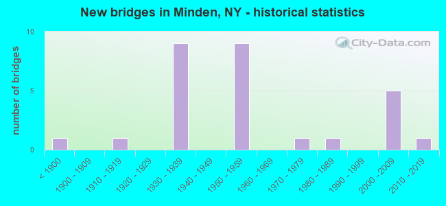
- New bridges - historical statistics
- 1Before 1900
- 11910-1919
- 91930-1939
- 91950-1959
- 11970-1979
- 11980-1989
- 52000-2009
- 12010-2019

- Reconstructed bridges - Historical Statistics
- 11950-1959
- 01960-1969
- 01970-1979
- 11980-1989
- 01990-1999
- 12000-2009


- Bridge Condition - Deck
- 13.6%Very good
- 22.7%Good
- 22.7%Satisfactory
- 31.8%Fair
- 9.1%Poor

- Bridge Condition - Superstructure
- 13.6%Excellent
- 13.6%Very good
- 22.7%Good
- 31.8%Satisfactory
- 13.6%Fair
- 4.5%Poor

- Bridge Condition - Substructure
- 13.6%Excellent
- 13.6%Very good
- 13.6%Good
- 27.3%Satisfactory
- 22.7%Fair
- 9.1%Poor

- Bridge Condition - Channel
- 13.6%Very good
- 27.3%Good
- 13.6%Satisfactory
- 22.7%Fair
- 22.7%Poor

- Bridge Condition - Culverts
- 50.0%Very good
- 50.0%Good
Find on map >> Show street view
Structure Number: 103092, Location: 6 MI W JCT SH 5S & SH 80 (Lat: 42.935028, Lng: -74.731731), Route carried "on" structure: State highway 80, Year Built: 1973, Status: Open, Structure Length: 0.64m (2.10ft), Average Daily Traffic: 766 (year 2018), Truck Traffic: 11%, Average Future Daily Traffic: 799 (year 2040), Design Load: HS 20, Features Intersected: SLATE CREEK
Minimum Vertical Clearance: 30+ m (98+ ft), Kilometerpoint: 2.092, Lanes on structure: 2, Base Highway Network: Yes, Owner: State Highway Agency, Approaching Roadway Width: 9.1m (29.9ft), Skew: 1 degrees, Material/Design: Steel, Design/Construction: Culvert, Number Of Spans In Main Unit: 1, Length of Maximum Span: 6.0m (19.7ft)
Condition: Channel: Good, Culverts: Very good, Operating Rating: 76.9 metric tons, Method Used To Determine Operating Rating: Field evaluation and documented engineering judgment, Inventory Rating: 32.7 metric tons, Method Used To Determine Inventory Rating: Field evaluation and documented engineering judgment, Structural Evaluation: Equal to present desirable criteria, Waterway Adequacy: Somewhat better than minimum adequacy, Approach Roadway Alignment: Meets minimum limits, Length Of Structure Improvement: 0.64m (2.10ft), Designated Inspection Frequency: Every 24 months, Inspection Date: July 2021, Bridge Improvement Cost: $84,000, Roadway Improvement Cost: $49,000, Total Project Cost: $133,000 ( Estimate for 2021)
Find on map >> Show street view
Structure Number: 103093, Location: 3.7 MI W JCT RTS 5S & 80 (Lat: 42.931572, Lng: -74.672428), Route carried "on" structure: State highway 80, Year Built: 1984, Status: Open, Structure Length: 2.87m (9.42ft), Average Daily Traffic: 766 (year 2018), Truck Traffic: 11%, Average Future Daily Traffic: 799 (year 2040), Design Load: HS 20, Features Intersected: OTSQUENE CREEK
Minimum Vertical Clearance: 30+ m (98+ ft), Kilometerpoint: 7.144, Lanes on structure: 2, Base Highway Network: Yes, Owner: State Highway Agency, Approaching Roadway Width: 9.1m (29.9ft), Skew: 1 degrees, Material/Design: Prestressed concrete, Design/Construction: Box Beam or Girders - Multiple, Number Of Spans In Main Unit: 1, Length of Maximum Span: 27.4m (89.9ft), Curb-To-Curb Width: 9.2m (30.2ft), Out-to-Out Width: 10.5m (34.4ft)
Condition: Deck: Satisfactory, Superstructure: Good, Substructure: Very good, Channel: Very good, Inventory Rating: 54.4 metric tons, Method Used To Determine Inventory Rating: Load Factor (LF), Structural Evaluation: Better than present minimum criteria, Deck Geometry: Equal to present minimum criteria, Waterway Adequacy: Meets minimum limits, Approach Roadway Alignment: Equal to present desirable criteria, Length Of Structure Improvement: 2.86m (9.38ft), Designated Inspection Frequency: Every 24 months, Inspection Date: March 2021, Bridge Improvement Cost: $637,000, Roadway Improvement Cost: $373,000, Total Project Cost: $1,010,000 ( Estimate for 2021), Wearing Surface/Protective System: Wearing Surface: Bituminous, Membrane: Preformed Fabric
Find on map >> Show street view
Structure Number: 103094, Location: 2.1 MI W JCT RTS 5S & 80 (Lat: 42.927814, Lng: -74.646258), Route carried "on" structure: State highway 80, Year Built: 2006, Status: Open, Structure Length: 4.33m (14.21ft), Average Daily Traffic: 766 (year 2018), Truck Traffic: 11%, Average Future Daily Traffic: 947 (year 2040), Design Load: HL 93, Features Intersected: OTSQUAGO CREEK
Minimum Vertical Clearance: 30+ m (98+ ft), Kilometerpoint: 9.429, Lanes on structure: 2, Base Highway Network: Yes, Owner: State Highway Agency, Approaching Roadway Width: 10.1m (33.1ft), Skew: 4 degrees, Material/Design: Steel, Design/Construction: Stringer/Multi-beam, Number Of Spans In Main Unit: 1, Length of Maximum Span: 42.5m (139.4ft), Curb-To-Curb Width: 10.2m (33.5ft), Out-to-Out Width: 11.2m (36.7ft)
Condition: Deck: Very good, Superstructure: Excellent, Substructure: Excellent, Channel: Very good, Operating Rating: 92.5 metric tons, Method Used To Determine Operating Rating: Load Factor (LF), Inventory Rating: 55.3 metric tons, Method Used To Determine Inventory Rating: Load Factor (LF), Structural Evaluation: Superior to present desirable criteria, Deck Geometry: Equal to present minimum criteria, Waterway Adequacy: Meets minimum limits, Approach Roadway Alignment: Equal to present desirable criteria, Length Of Structure Improvement: 4.32m (14.17ft), Designated Inspection Frequency: Every 24 months, Inspection Date: November 2020, Bridge Improvement Cost: $891,000, Roadway Improvement Cost: $522,000, Total Project Cost: $1,413,000 ( Estimate for 2021), Deck Structure Type: Concrete Cast-file-Place, Wearing Surface/Protective System: Wearing Surface: Integral Concrete, Deck Protection: Epoxy Coated Reinforcing
Find on map >> Show street view
Structure Number: 220524, Location: 2.0 MI NE OF STARKVILLE (Lat: 42.927842, Lng: -74.742467), Route carried "on" structure: Other road , Year Built: 1889, Year Reconstructed: 1962, Status: Posted for load, Structure Length: 1.68m (5.51ft), Average Daily Traffic: 2 (year 2016), Average Future Daily Traffic: 3 (year 2036), Features Intersected: OTSQUAGO CREEK, Facility Carried by Structure: H MOYER ROAD
Minimum Vertical Clearance: 30+ m (98+ ft), Kilometerpoint: 0.064, Lanes on structure: 1, Owner: Town or Township Highway Agency, Approaching Roadway Width: 2.7m (8.9ft), Material/Design: Steel, Design/Construction: Truss - Thru, Number Of Spans In Main Unit: 1, Length of Maximum Span: 13.4m (44.0ft), Curb-To-Curb Width: 3.3m (10.8ft), Out-to-Out Width: 3.6m (11.8ft)
Condition: Deck: Poor, Superstructure: Poor, Substructure: Poor, Channel: Poor, Operating Rating: 2.7 metric tons, Method Used To Determine Operating Rating: Field evaluation and documented engineering judgment, Inventory Rating: 2.7 metric tons, Method Used To Determine Inventory Rating: Field evaluation and documented engineering judgment, Structural Evaluation: High priority of corrective action, Deck Geometry: High priority of replacement, Waterway Adequacy: Meets minimum limits, Approach Roadway Alignment: Meets minimum limits, Bridge Posting: Required (Relationship of Operating Rating to Maximum Legal Load: > 39.9% below), Length Of Structure Improvement: 1.67m (5.48ft), Designated Inspection Frequency: Every 12 months, Critical Feature Inspection Frequency: Every 12 months, Inspection Date: May 2021, Critical Feature Inspection Date: May 2021, Bridge Improvement Cost: $482,000, Roadway Improvement Cost: $282,000, Total Project Cost: $764,000 ( Estimate for 2021), Deck Structure Type: Wood or Timber, Wearing Surface/Protective System: Wearing Surface: Wood or Timber
Find on map >> Show street view
Structure Number: 330943, Location: 2.5 MI NE OF STARKVILLE (Lat: 42.933406, Lng: -74.732147), Route carried "on" structure: Other road , Year Built: 2010, Status: Open, Structure Length: 1.77m (5.81ft), Average Daily Traffic: 42 (year 2018), Truck Traffic: 13%, Average Future Daily Traffic: 59 (year 2038), Design Load: HL 93, Features Intersected: OTSQUAGO CREEK, Facility Carried by Structure: CASLER ROAD
Minimum Vertical Clearance: 30+ m (98+ ft), Kilometerpoint: 0.097, Lanes on structure: 2, Owner: County Highway Agency, Approaching Roadway Width: 9.1m (29.9ft), Skew: 1 degrees, Material/Design: Prestressed concrete, Design/Construction: Box Beam or Girders - Multiple, Number Of Spans In Main Unit: 1, Length of Maximum Span: 16.8m (55.1ft), Curb-To-Curb Width: 9.1m (29.9ft), Out-to-Out Width: 10.1m (33.1ft)
Condition: Deck: Very good, Superstructure: Very good, Substructure: Good, Channel: Good, Operating Rating: 71.7 metric tons, Method Used To Determine Operating Rating: Load Factor (LF), Inventory Rating: 42.6 metric tons, Method Used To Determine Inventory Rating: Load Factor (LF), Structural Evaluation: Better than present minimum criteria, Deck Geometry: Better than present minimum criteria, Waterway Adequacy: Somewhat better than minimum adequacy, Approach Roadway Alignment: Equal to present desirable criteria, Length Of Structure Improvement: 1.76m (5.77ft), Designated Inspection Frequency: Every 24 months, Inspection Date: April 2021, Bridge Improvement Cost: $553,000, Roadway Improvement Cost: $324,000, Total Project Cost: $878,000 ( Estimate for 2021), Deck Structure Type: Concrete Cast-file-Place, Wearing Surface/Protective System: Wearing Surface: Integral Concrete, Deck Protection: Epoxy Coated Reinforcing
Find on map >> Show street view
Structure Number: 330945, Location: 3.0 MI E OF FORT PLAIN (Lat: 42.916742, Lng: -74.725336), Route carried "on" structure: County highway , Year Built: 1934, Status: Open, Structure Length: 1.07m (3.51ft), Average Daily Traffic: 278 (year 2017), Truck Traffic: 9%, Average Future Daily Traffic: 389 (year 2037), Features Intersected: S BR OTSQUAGO CK, Facility Carried by Structure: CR74 HESSVILLE ROA
Minimum Vertical Clearance: 30+ m (98+ ft), Kilometerpoint: 0.113, Lanes on structure: 2, Owner: County Highway Agency, Approaching Roadway Width: 5.2m (17.1ft), Material/Design: Steel, Design/Construction: Stringer/Multi-beam, Number Of Spans In Main Unit: 1, Length of Maximum Span: 10.4m (34.1ft), Curb-To-Curb Width: 6.1m (20.0ft), Out-to-Out Width: 7.2m (23.6ft)
Condition: Deck: Poor, Superstructure: Satisfactory, Substructure: Fair, Channel: Fair, Operating Rating: 58.1 metric tons, Method Used To Determine Operating Rating: Load Factor (LF), Inventory Rating: 34.5 metric tons, Method Used To Determine Inventory Rating: Load Factor (LF), Structural Evaluation: Somewhat better than minimum adequacy, Deck Geometry: Meets minimum limits, Waterway Adequacy: Meets minimum limits, Approach Roadway Alignment: Equal to present minimum criteria, Length Of Structure Improvement: 1.06m (3.48ft), Designated Inspection Frequency: Every 24 months, Inspection Date: April 2021, Bridge Improvement Cost: $185,000, Roadway Improvement Cost: $109,000, Total Project Cost: $294,000 ( Estimate for 2021), Deck Structure Type: Concrete Cast-file-Place, Wearing Surface/Protective System: Wearing Surface: Bituminous
Find on map >> Show street view
Structure Number: 330947, Location: 3.0 MI SE OF STARKVILLE (Lat: 42.905753, Lng: -74.720522), Route carried "on" structure: County highway , Year Built: 1936, Status: Open, Structure Length: 1.28m (4.20ft), Average Daily Traffic: 113 (year 2016), Truck Traffic: 7%, Average Future Daily Traffic: 158 (year 2036), Features Intersected: BOWMANS CREEK, Facility Carried by Structure: CR75 SALT SPRINGVI
Minimum Vertical Clearance: 30+ m (98+ ft), Kilometerpoint: 5.825, Lanes on structure: 2, Owner: County Highway Agency, Approaching Roadway Width: 5.2m (17.1ft), Skew: 2 degrees, Material/Design: Steel, Design/Construction: Stringer/Multi-beam, Number Of Spans In Main Unit: 1, Length of Maximum Span: 11.8m (38.7ft), Curb-To-Curb Width: 6.2m (20.3ft), Out-to-Out Width: 7.3m (24.0ft)
Condition: Deck: Satisfactory, Superstructure: Satisfactory, Substructure: Satisfactory, Channel: Poor, Operating Rating: 59.9 metric tons, Method Used To Determine Operating Rating: Field evaluation and documented engineering judgment, Inventory Rating: 22.8 metric tons, Method Used To Determine Inventory Rating: Field evaluation and documented engineering judgment, Structural Evaluation: Equal to present minimum criteria, Deck Geometry: Meets minimum limits, Waterway Adequacy: Meets minimum limits, Approach Roadway Alignment: Better than present minimum criteria, Length Of Structure Improvement: 1.28m (4.20ft), Designated Inspection Frequency: Every 24 months, Inspection Date: May 2021, Bridge Improvement Cost: $242,000, Roadway Improvement Cost: $142,000, Total Project Cost: $384,000 ( Estimate for 2021), Deck Structure Type: Concrete Cast-file-Place, Wearing Surface/Protective System: Wearing Surface: Bituminous
Find on map >> Show street view
Structure Number: 330948, Location: 4.0 MI NE OF STARKVILLE (Lat: 42.955608, Lng: -74.708033), Route carried "on" structure: County highway , Year Built: 2005, Status: Open, Structure Length: 1.40m (4.59ft), Average Daily Traffic: 81 (year 2017), Truck Traffic: 6%, Average Future Daily Traffic: 113 (year 2037), Design Load: HS 25 or greater, Features Intersected: N BR OTSQUAGO CK, Facility Carried by Structure: CR68 PARIS RD
Minimum Vertical Clearance: 30+ m (98+ ft), Kilometerpoint: 1.625, Lanes on structure: 2, Owner: County Highway Agency, Approaching Roadway Width: 9.4m (30.8ft), Skew: 4 degrees, Material/Design: Prestressed concrete, Design/Construction: Box Beam or Girders - Multiple, Number Of Spans In Main Unit: 1, Length of Maximum Span: 12.0m (39.4ft), Curb-To-Curb Width: 9.1m (29.9ft), Out-to-Out Width: 10.1m (33.1ft)
Condition: Deck: Very good, Superstructure: Excellent, Substructure: Very good, Channel: Satisfactory, Operating Rating: 86.2 metric tons, Method Used To Determine Operating Rating: Load Factor (LF), Inventory Rating: 51.7 metric tons, Method Used To Determine Inventory Rating: Load Factor (LF), Structural Evaluation: Equal to present desirable criteria, Deck Geometry: Better than present minimum criteria, Waterway Adequacy: Somewhat better than minimum adequacy, Approach Roadway Alignment: Equal to present desirable criteria, Length Of Structure Improvement: 1.40m (4.59ft), Designated Inspection Frequency: Every 24 months, Inspection Date: May 2021, Bridge Improvement Cost: $504,000, Roadway Improvement Cost: $295,000, Total Project Cost: $799,000 ( Estimate for 2021), Deck Structure Type: Concrete Cast-file-Place, Wearing Surface/Protective System: Wearing Surface: Monolithic Concrete, Deck Protection: Epoxy Coated Reinforcing
Find on map >> Show street view
Structure Number: 330949, Location: 4 MI W OF FORT PLAIN (Lat: 42.935325, Lng: -74.703842), Route carried "on" structure: County highway , Year Built: 1930, Year Reconstructed: 1992, Status: Open, Structure Length: 2.35m (7.71ft), Average Daily Traffic: 389 (year 2016), Truck Traffic: 6%, Average Future Daily Traffic: 545 (year 2036), Features Intersected: OTSQUAGO CREEK, Facility Carried by Structure: CR73 BROOKMANS COR
Minimum Vertical Clearance: 30+ m (98+ ft), Kilometerpoint: 6.854, Lanes on structure: 2, Owner: County Highway Agency, Approaching Roadway Width: 4.6m (15.1ft), Material/Design: Concrete, Design/Construction: Arch - Thru, Number Of Spans In Main Unit: 1, Length of Maximum Span: 21.3m (69.9ft), Curb-To-Curb Width: 5.5m (18.0ft), Out-to-Out Width: 6.6m (21.7ft)
Condition: Deck: Fair, Superstructure: Fair, Substructure: Fair, Channel: Satisfactory, Operating Rating: 59.1 metric tons, Method Used To Determine Operating Rating: Field evaluation and documented engineering judgment, Inventory Rating: 21.0 metric tons, Method Used To Determine Inventory Rating: Field evaluation and documented engineering judgment, Structural Evaluation: Somewhat better than minimum adequacy, Deck Geometry: High priority of corrective action, Waterway Adequacy: Somewhat better than minimum adequacy, Approach Roadway Alignment: Meets minimum limits, Length Of Structure Improvement: 2.34m (7.68ft), Designated Inspection Frequency: Every 24 months, Critical Feature Inspection Frequency: Every 24 months, Inspection Date: June 2021, Critical Feature Inspection Date: June 2021, Bridge Improvement Cost: $1,070,000, Roadway Improvement Cost: $627,000, Total Project Cost: $1,697,000 ( Estimate for 2021), Deck Structure Type: Concrete Cast-file-Place, Wearing Surface/Protective System: Wearing Surface: Bituminous, Membrane: Other
Find on map >> Show street view
Structure Number: 33095, Location: 3.5 MI W OF FT PLAIN (Lat: 42.926617, Lng: -74.698578), Route carried "on" structure: County highway , Year Built: 1936, Status: Open, Structure Length: 1.04m (3.41ft), Average Daily Traffic: 111 (year 2019), Truck Traffic: 4%, Average Future Daily Traffic: 155 (year 2039), Features Intersected: S B OTSQUAGO CRK, Facility Carried by Structure: FREYSBUSH ROAD
Minimum Vertical Clearance: 30+ m (98+ ft), Kilometerpoint: 0.853, Lanes on structure: 2, Owner: County Highway Agency, Approaching Roadway Width: 4.3m (14.1ft), Skew: 1 degrees, Material/Design: Steel, Design/Construction: Stringer/Multi-beam, Number Of Spans In Main Unit: 1, Length of Maximum Span: 9.7m (31.8ft), Curb-To-Curb Width: 6.0m (19.7ft), Out-to-Out Width: 7.1m (23.3ft)
Condition: Deck: Fair, Superstructure: Satisfactory, Substructure: Fair, Channel: Fair, Operating Rating: 65.1 metric tons, Method Used To Determine Operating Rating: Field evaluation and documented engineering judgment, Inventory Rating: 27.8 metric tons, Method Used To Determine Inventory Rating: Field evaluation and documented engineering judgment, Structural Evaluation: Somewhat better than minimum adequacy, Deck Geometry: High priority of corrective action, Waterway Adequacy: Meets minimum limits, Approach Roadway Alignment: Equal to present minimum criteria, Length Of Structure Improvement: 1.03m (3.38ft), Designated Inspection Frequency: Every 24 months, Inspection Date: June 2021, Bridge Improvement Cost: $367,000, Roadway Improvement Cost: $215,000, Total Project Cost: $582,000 ( Estimate for 2021), Deck Structure Type: Concrete Cast-file-Place, Wearing Surface/Protective System: Wearing Surface: Bituminous
Find on map >> Show street view
Structure Number: 330952, Location: 3.5 SW OF FORT PLAIN (Lat: 42.902203, Lng: -74.691106), Route carried "on" structure: County highway , Year Built: 2008, Status: Open, Structure Length: 1.80m (5.91ft), Average Daily Traffic: 278 (year 2017), Truck Traffic: 9%, Average Future Daily Traffic: 389 (year 2037), Design Load: HS 25 or greater, Features Intersected: S BR OTSQUAGO CRK, Facility Carried by Structure: CR74 HESSVILLE ROA
Minimum Vertical Clearance: 30+ m (98+ ft), Kilometerpoint: 3.347, Lanes on structure: 2, Owner: County Highway Agency, Approaching Roadway Width: 8.5m (27.9ft), Material/Design: Prestressed concrete, Design/Construction: Box Beam or Girders - Multiple, Number Of Spans In Main Unit: 1, Length of Maximum Span: 17.0m (55.8ft), Curb-To-Curb Width: 9.2m (30.2ft), Out-to-Out Width: 10.2m (33.5ft)
Condition: Deck: Good, Superstructure: Excellent, Substructure: Excellent, Channel: Good, Operating Rating: 72.6 metric tons, Method Used To Determine Operating Rating: Load Factor (LF), Inventory Rating: 42.6 metric tons, Method Used To Determine Inventory Rating: Load Factor (LF), Structural Evaluation: Superior to present desirable criteria, Deck Geometry: Equal to present minimum criteria, Waterway Adequacy: Equal to present desirable criteria, Approach Roadway Alignment: Equal to present desirable criteria, Length Of Structure Improvement: 1.79m (5.87ft), Designated Inspection Frequency: Every 24 months, Inspection Date: April 2021, Bridge Improvement Cost: $370,000, Roadway Improvement Cost: $217,000, Total Project Cost: $587,000 ( Estimate for 2021), Deck Structure Type: Concrete Cast-file-Place, Wearing Surface/Protective System: Wearing Surface: Integral Concrete, Deck Protection: Epoxy Coated Reinforcing
Find on map >> Show street view
Structure Number: 330953, Location: 3 MILES SW OF FORT PLAIN (Lat: 42.920544, Lng: -74.689400), Route carried "on" structure: County highway , Year Built: 1936, Status: Open, Structure Length: 1.07m (3.51ft), Average Daily Traffic: 111 (year 2019), Truck Traffic: 4%, Average Future Daily Traffic: 155 (year 2039), Features Intersected: S BR OTSQUAGO CRK, Facility Carried by Structure: FREYSBUSH ROAD
Minimum Vertical Clearance: 30+ m (98+ ft), Kilometerpoint: 1.963, Lanes on structure: 2, Owner: County Highway Agency, Approaching Roadway Width: 4.6m (15.1ft), Material/Design: Steel, Design/Construction: Stringer/Multi-beam, Number Of Spans In Main Unit: 1, Length of Maximum Span: 10.0m (32.8ft), Curb-To-Curb Width: 5.8m (19.0ft), Out-to-Out Width: 7.3m (24.0ft)
Condition: Deck: Fair, Superstructure: Satisfactory, Substructure: Satisfactory, Channel: Fair, Operating Rating: 64.6 metric tons, Method Used To Determine Operating Rating: Field evaluation and documented engineering judgment, Inventory Rating: 27.5 metric tons, Method Used To Determine Inventory Rating: Field evaluation and documented engineering judgment, Structural Evaluation: Equal to present minimum criteria, Deck Geometry: High priority of corrective action, Waterway Adequacy: Meets minimum limits, Approach Roadway Alignment: Meets minimum limits, Length Of Structure Improvement: 1.06m (3.48ft), Designated Inspection Frequency: Every 24 months, Inspection Date: June 2021, Bridge Improvement Cost: $215,000, Roadway Improvement Cost: $126,000, Total Project Cost: $341,000 ( Estimate for 2021), Deck Structure Type: Concrete Cast-file-Place, Wearing Surface/Protective System: Wearing Surface: Bituminous
Find on map >> Show street view
Structure Number: 330954, Location: 3 MI WEST OF FORT PLAIN (Lat: 42.947419, Lng: -74.692367), Route carried "on" structure: County highway , Year Built: 1938, Status: Posted for load, Structure Length: 1.46m (4.79ft), Average Daily Traffic: 300 (year 2019), Truck Traffic: 8%, Average Future Daily Traffic: 420 (year 2039), Features Intersected: N BR OTSQUAGO CRK, Facility Carried by Structure: CR66 SANDERS ROAD
Minimum Vertical Clearance: 30+ m (98+ ft), Kilometerpoint: 1.094, Lanes on structure: 2, Owner: County Highway Agency, Approaching Roadway Width: 4.9m (16.1ft), Skew: 2 degrees, Material/Design: Steel, Design/Construction: Stringer/Multi-beam, Number Of Spans In Main Unit: 1, Length of Maximum Span: 14.0m (45.9ft), Curb-To-Curb Width: 5.5m (18.0ft), Out-to-Out Width: 6.4m (21.0ft)
Condition: Deck: Fair, Superstructure: Fair, Substructure: Fair, Channel: Fair, Operating Rating: 11.8 metric tons, Method Used To Determine Operating Rating: Field evaluation and documented engineering judgment, Inventory Rating: 11.8 metric tons, Method Used To Determine Inventory Rating: Field evaluation and documented engineering judgment, Structural Evaluation: Meets minimum limits, Deck Geometry: High priority of corrective action, Waterway Adequacy: Meets minimum limits, Approach Roadway Alignment: Equal to present minimum criteria, Bridge Posting: Required (Relationship of Operating Rating to Maximum Legal Load: > 39.9% below), Length Of Structure Improvement: 1.40m (4.59ft), Designated Inspection Frequency: Every 12 months, Inspection Date: April 2021, Bridge Improvement Cost: $242,000, Roadway Improvement Cost: $142,000, Total Project Cost: $383,000 ( Estimate for 2021), Deck Structure Type: Concrete Cast-file-Place, Wearing Surface/Protective System: Wearing Surface: Bituminous
Find on map >> Show street view
Structure Number: 330957, Location: 3 MI SW OF FORT PLAIN (Lat: 42.909119, Lng: -74.685981), Route carried "on" structure: Other road , Year Built: 1937, Status: Open, Structure Length: 1.01m (3.31ft), Average Daily Traffic: 81 (year 2016), Truck Traffic: 9%, Average Future Daily Traffic: 113 (year 2036), Features Intersected: S BR OTSQUAGO CK, Facility Carried by Structure: KEESLER CORNERS RD
Minimum Vertical Clearance: 30+ m (98+ ft), Kilometerpoint: 0.917, Lanes on structure: 2, Owner: County Highway Agency, Approaching Roadway Width: 4.6m (15.1ft), Material/Design: Steel, Design/Construction: Stringer/Multi-beam, Number Of Spans In Main Unit: 1, Length of Maximum Span: 9.8m (32.2ft), Curb-To-Curb Width: 5.6m (18.4ft), Out-to-Out Width: 6.5m (21.3ft)
Condition: Deck: Satisfactory, Superstructure: Satisfactory, Substructure: Satisfactory, Channel: Poor, Operating Rating: 65.1 metric tons, Method Used To Determine Operating Rating: Field evaluation and documented engineering judgment, Inventory Rating: 27.8 metric tons, Method Used To Determine Inventory Rating: Field evaluation and documented engineering judgment, Structural Evaluation: Equal to present minimum criteria, Deck Geometry: Meets minimum limits, Waterway Adequacy: Meets minimum limits, Approach Roadway Alignment: Equal to present minimum criteria, Length Of Structure Improvement: 1.00m (3.28ft), Designated Inspection Frequency: Every 24 months, Inspection Date: April 2021, Bridge Improvement Cost: $209,000, Roadway Improvement Cost: $122,000, Total Project Cost: $331,000 ( Estimate for 2021), Deck Structure Type: Concrete Cast-file-Place, Wearing Surface/Protective System: Wearing Surface: Bituminous
Find on map >> Show street view
Structure Number: 330958, Location: 2.3 MI E OF FORT PLAIN (Lat: 42.938456, Lng: -74.683375), Route carried "on" structure: County highway , Year Built: 2009, Status: Open, Structure Length: 2.13m (6.99ft), Average Daily Traffic: 197 (year 2017), Truck Traffic: 4%, Average Future Daily Traffic: 276 (year 2037), Features Intersected: N BR OTSQUAGO CK, Facility Carried by Structure: CR69 PICKLE HILL R
Minimum Vertical Clearance: 30+ m (98+ ft), Kilometerpoint: 1.223, Lanes on structure: 2, Owner: County Highway Agency, Approaching Roadway Width: 9.1m (29.9ft), Skew: 1 degrees, Material/Design: Prestressed concrete, Design/Construction: Box Beam or Girders - Multiple, Number Of Spans In Main Unit: 1, Length of Maximum Span: 20.1m (65.9ft), Curb-To-Curb Width: 9.2m (30.2ft), Out-to-Out Width: 10.2m (33.5ft)
Condition: Deck: Good, Superstructure: Very good, Substructure: Excellent, Channel: Satisfactory, Operating Rating: 73.5 metric tons, Method Used To Determine Operating Rating: Load Factor (LF), Inventory Rating: 43.5 metric tons, Method Used To Determine Inventory Rating: Load Factor (LF), Structural Evaluation: Equal to present desirable criteria, Deck Geometry: Equal to present minimum criteria, Waterway Adequacy: Equal to present minimum criteria, Approach Roadway Alignment: Equal to present desirable criteria, Length Of Structure Improvement: 2.13m (6.99ft), Designated Inspection Frequency: Every 24 months, Inspection Date: September 2021, Bridge Improvement Cost: $621,000, Roadway Improvement Cost: $364,000, Total Project Cost: $985,000 ( Estimate for 2021), Deck Structure Type: Concrete Cast-file-Place, Wearing Surface/Protective System: Wearing Surface: Integral Concrete, Deck Protection: Epoxy Coated Reinforcing
Find on map >> Show street view
Structure Number: 330959, Location: 3 MI SW OF FORT PLAIN (Lat: 42.899081, Lng: -74.683606), Route carried "on" structure: Other road , Year Built: 1936, Status: Open, Structure Length: 0.91m (2.99ft), Average Daily Traffic: 31 (year 2016), Truck Traffic: 3%, Average Future Daily Traffic: 43 (year 2036), Features Intersected: S BR OTSQUAGO CRK, Facility Carried by Structure: WALTS ROAD
Minimum Vertical Clearance: 30+ m (98+ ft), Kilometerpoint: 0.032, Lanes on structure: 2, Owner: County Highway Agency, Approaching Roadway Width: 4.9m (16.1ft), Material/Design: Steel, Design/Construction: Stringer/Multi-beam, Number Of Spans In Main Unit: 1, Length of Maximum Span: 8.5m (27.9ft), Curb-To-Curb Width: 5.0m (16.4ft), Out-to-Out Width: 5.6m (18.4ft)
Condition: Deck: Fair, Superstructure: Satisfactory, Substructure: Satisfactory, Channel: Fair, Operating Rating: 68.1 metric tons, Method Used To Determine Operating Rating: Field evaluation and documented engineering judgment, Inventory Rating: 29.4 metric tons, Method Used To Determine Inventory Rating: Field evaluation and documented engineering judgment, Structural Evaluation: Equal to present minimum criteria, Deck Geometry: High priority of corrective action, Waterway Adequacy: Meets minimum limits, Approach Roadway Alignment: Equal to present desirable criteria, Length Of Structure Improvement: 0.91m (2.99ft), Designated Inspection Frequency: Every 24 months, Inspection Date: June 2021, Bridge Improvement Cost: $152,000, Roadway Improvement Cost: $89,000, Total Project Cost: $240,000 ( Estimate for 2021), Deck Structure Type: Concrete Cast-file-Place, Wearing Surface/Protective System: Wearing Surface: Bituminous
Find on map >> Show street view
Structure Number: 33096, Location: 3.0 MI SW OF FORT PLAIN (Lat: 42.901583, Lng: -74.677739), Route carried "on" structure: Other road , Year Built: 1936, Status: Open, Structure Length: 1.28m (4.20ft), Average Daily Traffic: 31 (year 2016), Truck Traffic: 3%, Average Future Daily Traffic: 43 (year 2036), Features Intersected: S B OTSQUAGO CRK, Facility Carried by Structure: WALTS ROAD
Minimum Vertical Clearance: 30+ m (98+ ft), Kilometerpoint: 0.660, Lanes on structure: 2, Owner: County Highway Agency, Approaching Roadway Width: 4.6m (15.1ft), Material/Design: Steel, Design/Construction: Stringer/Multi-beam, Number Of Spans In Main Unit: 1, Length of Maximum Span: 11.8m (38.7ft), Curb-To-Curb Width: 4.9m (16.1ft), Out-to-Out Width: 5.7m (18.7ft)
Condition: Deck: Satisfactory, Superstructure: Satisfactory, Substructure: Satisfactory, Channel: Poor, Operating Rating: 60.5 metric tons, Method Used To Determine Operating Rating: Field evaluation and documented engineering judgment, Inventory Rating: 25.3 metric tons, Method Used To Determine Inventory Rating: Field evaluation and documented engineering judgment, Structural Evaluation: Equal to present minimum criteria, Deck Geometry: High priority of corrective action, Waterway Adequacy: Meets minimum limits, Approach Roadway Alignment: Equal to present minimum criteria, Length Of Structure Improvement: 1.28m (4.20ft), Designated Inspection Frequency: Every 24 months, Inspection Date: June 2021, Bridge Improvement Cost: $184,000, Roadway Improvement Cost: $108,000, Total Project Cost: $292,000 ( Estimate for 2021), Deck Structure Type: Concrete Cast-file-Place, Wearing Surface/Protective System: Wearing Surface: Bituminous
Find on map >> Show street view
Structure Number: 330968, Location: 1.5 MI W OF FT PLAIN (Lat: 42.928289, Lng: -74.660028), Route carried "on" structure: Other road , Year Built: 2009, Status: Open, Structure Length: 2.90m (9.51ft), Average Daily Traffic: 170 (year 2016), Truck Traffic: 4%, Average Future Daily Traffic: 238 (year 2036), Design Load: HS 25 or greater, Features Intersected: OTSQUAGO CREEK, Facility Carried by Structure: SPRING STREET
Minimum Vertical Clearance: 30+ m (98+ ft), Kilometerpoint: 2.220, Lanes on structure: 2, Owner: County Highway Agency, Approaching Roadway Width: 9.1m (29.9ft), Skew: 4 degrees, Material/Design: Prestressed concrete, Design/Construction: Box Beam or Girders - Multiple, Number Of Spans In Main Unit: 1, Length of Maximum Span: 27.1m (88.9ft), Curb-To-Curb Width: 9.2m (30.2ft), Out-to-Out Width: 10.2m (33.5ft)
Condition: Deck: Satisfactory, Superstructure: Very good, Substructure: Very good, Channel: Poor, Operating Rating: 68.0 metric tons, Method Used To Determine Operating Rating: Load Factor (LF), Inventory Rating: 40.8 metric tons, Method Used To Determine Inventory Rating: Load Factor (LF), Structural Evaluation: Equal to present desirable criteria, Deck Geometry: Equal to present minimum criteria, Waterway Adequacy: Meets minimum limits, Approach Roadway Alignment: Equal to present desirable criteria, Length Of Structure Improvement: 2.89m (9.48ft), Designated Inspection Frequency: Every 24 months, Inspection Date: October 2021, Bridge Improvement Cost: $956,000, Roadway Improvement Cost: $560,000, Total Project Cost: $1,515,000 ( Estimate for 2021), Deck Structure Type: Concrete Cast-file-Place, Wearing Surface/Protective System: Wearing Surface: Integral Concrete, Deck Protection: Epoxy Coated Reinforcing
Find on map >> Show street view
Structure Number: 336725, Location: 6 MILES WEST OF FT.PLAIN (Lat: 42.989181, Lng: -74.716703), Route carried "on" structure: County highway , Year Built: 1952, Status: Open, Structure Length: 1.04m (3.41ft), Average Daily Traffic: 385 (year 2016), Truck Traffic: 3%, Average Future Daily Traffic: 539 (year 2036), Features Intersected: I-90 NYS Thruway, I-90 N, Facility Carried by Structure: CR65 RIVER ROAD
Minimum Vertical Clearance: 6.05m (19.85ft), Kilometerpoint: 2.220, Lanes on structure: 2, Owner: County Highway Agency, Approaching Roadway Width: 5.8m (19.0ft), Skew: 6 degrees, Material/Design: Concrete, Design/Construction: Culvert, Number Of Spans In Main Unit: 1, Length of Maximum Span: 8.8m (28.9ft), Curb or Sidewalk Widths: Left: 0.9m (3.0ft), Right: 0.9m (3.0ft), Curb-To-Curb Width: 7.9m (25.9ft), Out-to-Out Width: 10.3m (33.8ft)
Condition: Channel: Good, Culverts: Good, Operating Rating: 89.8 metric tons, Method Used To Determine Operating Rating: Load Factor (LF), Inventory Rating: 65.3 metric tons, Method Used To Determine Inventory Rating: Load Factor (LF), Structural Evaluation: Better than present minimum criteria, Deck Geometry: Somewhat better than minimum adequacy, Waterway Adequacy: Somewhat better than minimum adequacy, Approach Roadway Alignment: Meets minimum limits, Length Of Structure Improvement: 1.03m (3.38ft), Designated Inspection Frequency: Every 24 months, Inspection Date: June 2021, Bridge Improvement Cost: $208,000, Roadway Improvement Cost: $122,000, Total Project Cost: $330,000 ( Estimate for 2021)
Find on map >> Show street view
Structure Number: 442502, Location: .3 MI N JCT I90 & C.R.65 (Lat: 42.992119, Lng: -74.717439), Route carried "on" structure: County highway , Year Built: 1910, Year Reconstructed: 2006, Status: Posted for load-capacity, Structure Length: 8.53m (27.99ft), Average Daily Traffic: 245 (year 2020), Truck Traffic: 8%, Average Future Daily Traffic: 343 (year 2040), Design Load: H 20, Features Intersected: NYS Canal Trail, ERIE BA, Facility Carried by Structure: CR65 RIVER ROAD
Minimum Vertical Clearance: 30+ m (98+ ft), Kilometerpoint: 1.673, Lanes on structure: 1, Owner: State Highway Agency, Approaching Roadway Width: 4.3m (14.1ft), Navigation Control: Yes ( Vertical Clearance: 7.0m (23.0ft), Horizontal Clearance: 13.1m (43.0ft)), Material/Design: Steel, Number Of Spans In Main Unit: 1, Number Of Approach Spans: 5, Length of Maximum Span: 45.1m (148.0ft), Curb-To-Curb Width: 4.4m (14.4ft), Out-to-Out Width: 6.5m (21.3ft)
Condition: Deck: Good, Superstructure: Fair, Substructure: Poor, Channel: Good, Operating Rating: 35.4 metric tons, Method Used To Determine Operating Rating: Allowable Stress (AS), Inventory Rating: 19.1 metric tons, Method Used To Determine Inventory Rating: Allowable Stress (AS), Structural Evaluation: Meets minimum limits, Deck Geometry: High priority of replacement, Waterway Adequacy: Somewhat better than minimum adequacy, Approach Roadway Alignment: Meets minimum limits, Length Of Structure Improvement: 8.53m (27.99ft), Designated Inspection Frequency: Every 24 months, Critical Feature Inspection Frequency: Every 24 months, Underwater Inspection Frequency: Every 60 months, Inspection Date: October 2021, Critical Feature Inspection Date: October 2021, Underwater Inspection Date: July 2018, Bridge Improvement Cost: $894,000, Roadway Improvement Cost: $524,000, Total Project Cost: $1,418,000 ( Estimate for 2021), Wearing Surface/Protective System: Wearing Surface: Bituminous
Find on map >> Show street view
Structure Number: 5515991, Location: 0.3 MI S OF ST JOHNSVILLE (Lat: 42.990922, Lng: -74.682314), Route carried "on" structure: Interstate 90, Year Built: 1954, Status: Open, Structure Length: 1.16m (3.81ft), Average Daily Traffic: 11,090 (year 2014), Truck Traffic: 23%, Design Load: HS 20+Mod, Features Intersected: BRIDGE ST CR 61
Minimum Vertical Clearance: 30+ m (98+ ft), Kilometerpoint: 327.142, Lanes on structure: 2, Lanes under structure: 2, Base Highway Network: Yes, Toll: On Interstate toll segment, Owner: State Toll Authority, Approaching Roadway Width: 12.5m (41.0ft), Skew: 3 degrees, Material/Design: Concrete, Design/Construction: Frame, Number Of Spans In Main Unit: 1, Length of Maximum Span: 11.3m (37.1ft), Curb or Sidewalk Widths: Left: 0.7m (2.3ft), Right: 0.7m (2.3ft), Curb-To-Curb Width: 14.9m (48.9ft), Out-to-Out Width: 17.0m (55.8ft)
Condition: Deck: Good, Superstructure: Good, Substructure: Good, Operating Rating: 80.6 metric tons, Method Used To Determine Operating Rating: Field evaluation and documented engineering judgment, Inventory Rating: 32.7 metric tons, Method Used To Determine Inventory Rating: Field evaluation and documented engineering judgment, Structural Evaluation: Better than present minimum criteria, Deck Geometry: Superior to present desirable criteria, Underclear: Meets minimum limits, Approach Roadway Alignment: Equal to present desirable criteria, Length Of Structure Improvement: 1.15m (3.77ft), Designated Inspection Frequency: Every 24 months, Inspection Date: May 2020, Bridge Improvement Cost: $1,346,000, Roadway Improvement Cost: $788,000, Total Project Cost: $2,135,000 ( Estimate for 2021), Wearing Surface/Protective System: Wearing Surface: Bituminous
Find on map >> Show street view
Structure Number: 5515992, Location: 0.3 MI S OF ST JOHNSVILLE (Lat: 42.990672, Lng: -74.682517), Route carried "on" structure: Interstate 90, Year Built: 1954, Status: Open, Structure Length: 1.16m (3.81ft), Average Daily Traffic: 9,805 (year 2020), Truck Traffic: 31%, Average Future Daily Traffic: 10,906 (year 2040), Design Load: HS 20+Mod, Features Intersected: BRIDGE ST CR 61
Minimum Vertical Clearance: 30+ m (98+ ft), Kilometerpoint: 4.875, Lanes on structure: 2, Lanes under structure: 2, Base Highway Network: Yes, Toll: On Interstate toll segment, Owner: State Toll Authority, Approaching Roadway Width: 12.5m (41.0ft), Skew: 3 degrees, Material/Design: Concrete, Design/Construction: Frame, Number Of Spans In Main Unit: 1, Length of Maximum Span: 11.3m (37.1ft), Curb or Sidewalk Widths: Left: 0.7m (2.3ft), Right: 0.7m (2.3ft), Curb-To-Curb Width: 14.9m (48.9ft), Out-to-Out Width: 17.0m (55.8ft)
Condition: Deck: Good, Superstructure: Good, Substructure: Good, Operating Rating: 80.6 metric tons, Method Used To Determine Operating Rating: Field evaluation and documented engineering judgment, Inventory Rating: 32.7 metric tons, Method Used To Determine Inventory Rating: Field evaluation and documented engineering judgment, Structural Evaluation: Better than present minimum criteria, Deck Geometry: Superior to present desirable criteria, Underclear: Meets minimum limits, Approach Roadway Alignment: Equal to present desirable criteria, Length Of Structure Improvement: 1.15m (3.77ft), Designated Inspection Frequency: Every 24 months, Inspection Date: May 2020, Bridge Improvement Cost: $1,322,000, Roadway Improvement Cost: $774,000, Total Project Cost: $2,097,000 ( Estimate for 2021), Wearing Surface/Protective System: Wearing Surface: Bituminous
Find on map >> Show street view
Structure Number: 5516001, Location: 10.9 MI W I-90 INT 29 (Lat: 42.989300, Lng: -74.716781), Route carried "on" structure: Interstate 90, Year Built: 1954, Status: Open, Structure Length: 1.77m (5.81ft), Average Daily Traffic: 11,090 (year 2014), Truck Traffic: 23%, Design Load: HS 20+Mod, Features Intersected: RIVER RD CR 65, UNNAMED
Minimum Vertical Clearance: 30+ m (98+ ft), Kilometerpoint: 329.925, Lanes on structure: 2, Lanes under structure: 2, Base Highway Network: Yes, Toll: On Interstate toll segment, Owner: State Toll Authority, Approaching Roadway Width: 11.3m (37.1ft), Skew: 2 degrees, Material/Design: Steel, Design/Construction: Stringer/Multi-beam, Number Of Spans In Main Unit: 1, Length of Maximum Span: 16.2m (53.1ft), Curb or Sidewalk Widths: Left: 0.0m, Right: 0.7m (2.3ft), Curb-To-Curb Width: 15.5m (50.9ft), Out-to-Out Width: 17.1m (56.1ft)
Condition: Deck: Fair, Superstructure: Good, Substructure: Satisfactory, Channel: Very good, Operating Rating: 60.8 metric tons, Method Used To Determine Operating Rating: Load Factor (LF), Inventory Rating: 36.3 metric tons, Method Used To Determine Inventory Rating: Load Factor (LF), Structural Evaluation: Equal to present minimum criteria, Deck Geometry: Superior to present desirable criteria, Underclear: High priority of corrective action, Waterway Adequacy: Equal to present minimum criteria, Approach Roadway Alignment: Equal to present desirable criteria, Length Of Structure Improvement: 1.76m (5.77ft), Designated Inspection Frequency: Every 24 months, Inspection Date: March 2021, Bridge Improvement Cost: $1,472,000, Roadway Improvement Cost: $862,000, Total Project Cost: $2,335,000 ( Estimate for 2021), Deck Structure Type: Concrete Cast-file-Place, Wearing Surface/Protective System: Wearing Surface: Bituminous, Membrane: Other
Find on map >> Show street view
Structure Number: 5516002, Location: 10.9 MI W I-90 INT 29 (Lat: 42.989058, Lng: -74.716625), Route carried "on" structure: Interstate 90, Year Built: 1954, Status: Open, Structure Length: 1.77m (5.81ft), Average Daily Traffic: 9,805 (year 2020), Truck Traffic: 31%, Average Future Daily Traffic: 10,906 (year 2040), Design Load: HS 20+Mod, Features Intersected: RIVER RD CR 65, UNNAMED
Minimum Vertical Clearance: 30+ m (98+ ft), Kilometerpoint: 2.092, Lanes on structure: 2, Lanes under structure: 2, Base Highway Network: Yes, Toll: On Interstate toll segment, Owner: State Toll Authority, Approaching Roadway Width: 11.3m (37.1ft), Skew: 2 degrees, Material/Design: Steel, Design/Construction: Stringer/Multi-beam, Number Of Spans In Main Unit: 1, Length of Maximum Span: 16.2m (53.1ft), Curb or Sidewalk Widths: Left: 0.7m (2.3ft), Right: 0.0m, Curb-To-Curb Width: 15.5m (50.9ft), Out-to-Out Width: 17.1m (56.1ft)
Condition: Deck: Fair, Superstructure: Good, Substructure: Fair, Channel: Good, Operating Rating: 61.7 metric tons, Method Used To Determine Operating Rating: Load Factor (LF), Inventory Rating: 37.2 metric tons, Method Used To Determine Inventory Rating: Load Factor (LF), Structural Evaluation: Somewhat better than minimum adequacy, Deck Geometry: Superior to present desirable criteria, Underclear: High priority of corrective action, Waterway Adequacy: Meets minimum limits, Approach Roadway Alignment: Equal to present desirable criteria, Length Of Structure Improvement: 1.76m (5.77ft), Designated Inspection Frequency: Every 24 months, Inspection Date: March 2021, Bridge Improvement Cost: $1,355,000, Roadway Improvement Cost: $794,000, Total Project Cost: $2,149,000 ( Estimate for 2021), Deck Structure Type: Concrete Cast-file-Place, Wearing Surface/Protective System: Wearing Surface: Bituminous, Membrane: Other
Find on map >> Show street view
Structure Number: 5515991, Location: 0.3 MI S OF ST JOHNSVILLE (Lat: 42.990922, Lng: -74.682314), Route carried "under" structure: County highway , Year Built: 1954, Structure Length: 0. m, Average Daily Traffic: 655 (year 2017), Truck Traffic: 11%, Features Intersected: BRIDGE ST CR 61, Facility Carried by Structure: RTE I90
Minimum Vertical Clearance: 4.78m (15.68ft), Kilometerpoint: 0.113, Lanes on structure: 2, Lanes under structure: 2, Material/Design: Concrete, Design/Construction: Frame, Length of Maximum Span: 11.3m (37.1ft)
Find on map >> Show street view
Structure Number: 5515992, Location: 0.3 MI S OF ST JOHNSVILLE (Lat: 42.990672, Lng: -74.682517), Route carried "under" structure: County highway , Year Built: 1954, Structure Length: 0. m, Average Daily Traffic: 655 (year 2017), Truck Traffic: 11%, Features Intersected: BRIDGE ST CR 61, Facility Carried by Structure: RTE I90
Minimum Vertical Clearance: 4.62m (15.16ft), Kilometerpoint: 0.000, Lanes on structure: 2, Lanes under structure: 2, Material/Design: Concrete, Design/Construction: Frame, Length of Maximum Span: 11.3m (37.1ft)
Find on map >> Show street view
Structure Number: 5516001, Location: 10.9 MI W I-90 INT 29 (Lat: 42.989300, Lng: -74.716781), Route carried "under" structure: County highway , Year Built: 1954, Structure Length: 0. m, Average Daily Traffic: 193 (year 2016), Truck Traffic: 3%, Features Intersected: RIVER RD CR 65, UNNAMED, Facility Carried by Structure: RTE I90
Minimum Vertical Clearance: 4.88m (16.01ft), Kilometerpoint: 2.204, Lanes on structure: 2, Lanes under structure: 2, Material/Design: Steel, Design/Construction: Stringer/Multi-beam, Length of Maximum Span: 16.2m (53.1ft)
Find on map >> Show street view
Structure Number: 5516002, Location: 10.9 MI W I-90 INT 29 (Lat: 42.989058, Lng: -74.716625), Route carried "under" structure: County highway , Year Built: 1954, Structure Length: 0. m, Average Daily Traffic: 193 (year 2016), Truck Traffic: 3%, Features Intersected: RIVER RD CR 65, UNNAMED, Facility Carried by Structure: RTE I90
Minimum Vertical Clearance: 4.57m (14.99ft), Kilometerpoint: 2.237, Lanes on structure: 2, Lanes under structure: 2, Material/Design: Steel, Design/Construction: Stringer/Multi-beam, Length of Maximum Span: 16.2m (53.1ft)