Bridge Statistics for Mineral Ridge, Ohio (OH)
Condition, Traffic, Stress, Structural Evaluation, Project Costs
- National Bridge Inventory (NBI) Statistics
- 26Number of bridges
- 427ft / 130mTotal length
- $1,000Total costs
- 416,664Total average daily traffic
- 75,067Total average daily truck traffic
- National Bridge Inventory (NBI) Registered Bridges for Mineral Ridge
- No street view available for this location
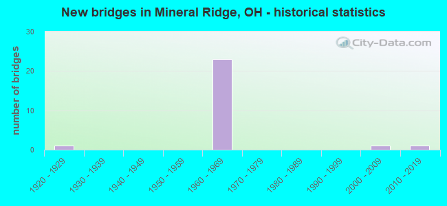
- New bridges - historical statistics
- 11920-1929
- 231960-1969
- 12000-2009
- 12010-2019

- Reconstructed bridges - Historical Statistics
- 11980-1989
- 81990-1999
- 22000-2009
- 12010-2019


- Bridge Condition - Deck
- 7.1%Excellent
- 7.1%Very good
- 78.6%Good
- 7.1%Fair

- Bridge Condition - Superstructure
- 13.3%Excellent
- 13.3%Very good
- 66.7%Good
- 6.7%Fair

- Bridge Condition - Substructure
- 13.3%Excellent
- 20.0%Very good
- 66.7%Good
Find on map >> Show street view
Structure Number: 5000807, Location: 1.92 MI N OF MAHONING AVE (Lat: 41.124619, Lng: -80.750969), Route carried "on" structure: State highway 11, Year Built: 1966, Year Reconstructed: 2002, Status: Open, Structure Length: 8.14m (26.71ft), Average Daily Traffic: 19,149 (year 2015), Truck Traffic: 5%, Average Future Daily Traffic: 26,579 (year 2035), Design Load: HS 20+Mod, Features Intersected: SR 11 SB OVER IR 80 EB
Minimum Vertical Clearance: 4.60m (15.09ft), Kilometerpoint: 25.605, Lanes on structure: 2, Lanes under structure: 3, Base Highway Network: Yes, Owner: State Highway Agency, Approaching Roadway Width: 10.4m (34.1ft), Skew: 5 degrees, Material/Design: Steel continuous, Design/Construction: Stringer/Multi-beam, Number Of Spans In Main Unit: 3, Length of Maximum Span: 32.3m (106.0ft), Curb-To-Curb Width: 15.9m (52.2ft), Out-to-Out Width: 16.8m (55.1ft)
Condition: Deck: Good, Superstructure: Good, Substructure: Good, Operating Rating: 42.1 metric tons, Method Used To Determine Operating Rating: Load Factor (LF) rating reported by rating factor (RF) method using MS18 loading, Inventory Rating: 32.4 metric tons, Method Used To Determine Inventory Rating: Load Factor (LF) rating reported by rating factor (RF) method using MS18 loading, Structural Evaluation: Better than present minimum criteria, Deck Geometry: Meets minimum limits, Underclear: Meets minimum limits, Approach Roadway Alignment: Equal to present desirable criteria, Designated Inspection Frequency: Every 24 months, Inspection Date: April 2021, Deck Structure Type: Concrete Cast-file-Place, Wearing Surface/Protective System: Wearing Surface: Monolithic Concrete, Deck Protection: Epoxy Coated Reinforcing
Find on map >> Show street view
Structure Number: 5000815, Location: 0.14 MI S OF IR 80 (Lat: 41.124081, Lng: -80.750850), Route carried "on" structure: State highway 11, Year Built: 1965, Year Reconstructed: 2002, Status: Open, Structure Length: 7.25m (23.79ft), Average Daily Traffic: 12,072 (year 2015), Truck Traffic: 17%, Average Future Daily Traffic: 26,579 (year 2035), Design Load: HS 20+Mod, Features Intersected: SR 11SB
Minimum Vertical Clearance: 30+ m (98+ ft), Kilometerpoint: 25.830, Lanes on structure: 1, Lanes under structure: 2, Base Highway Network: Yes, Owner: State Highway Agency, Approaching Roadway Width: 8.5m (27.9ft), Skew: 1 degrees, Material/Design: Steel continuous, Design/Construction: Stringer/Multi-beam, Number Of Spans In Main Unit: 3, Length of Maximum Span: 27.4m (89.9ft), Curb-To-Curb Width: 7.9m (25.9ft), Out-to-Out Width: 9.1m (29.9ft)
Condition: Deck: Good, Superstructure: Good, Substructure: Good, Operating Rating: 29.2 metric tons, Method Used To Determine Operating Rating: Load and Resistance Factor Rating (LRFR) rating reported by rating factor(RF) method using HL-93 loadings, Inventory Rating: 22.7 metric tons, Method Used To Determine Inventory Rating: Load and Resistance Factor Rating (LRFR) rating reported by rating factor(RF) method using HL-93 loadings, Structural Evaluation: Somewhat better than minimum adequacy, Deck Geometry: High priority of corrective action, Underclear: High priority of corrective action, Approach Roadway Alignment: Equal to present desirable criteria, Designated Inspection Frequency: Every 24 months, Inspection Date: April 2021, Deck Structure Type: Concrete Cast-file-Place, Wearing Surface/Protective System: Wearing Surface: Monolithic Concrete, Deck Protection: Epoxy Coated Reinforcing
Find on map >> Show street view
Structure Number: 5000823, Location: 1.89 MI N OF MAHONING AVE (Lat: 41.126150, Lng: -80.749650), Route carried "on" structure: State highway 11, Year Built: 1965, Year Reconstructed: 2002, Status: Open, Structure Length: 7.01m (23.00ft), Average Daily Traffic: 4,730 (year 2015), Truck Traffic: 5%, Average Future Daily Traffic: 6,565 (year 2035), Design Load: HS 20+Mod, Features Intersected: OVER MAH-IR 680-0.04 WB
Minimum Vertical Clearance: 30+ m (98+ ft), Kilometerpoint: 25.846, Lanes on structure: 1, Lanes under structure: 2, Base Highway Network: Yes, Owner: State Highway Agency, Approaching Roadway Width: 10.1m (33.1ft), Skew: 5 degrees, Material/Design: Steel continuous, Design/Construction: Stringer/Multi-beam, Number Of Spans In Main Unit: 3, Length of Maximum Span: 26.2m (86.0ft), Curb-To-Curb Width: 10.1m (33.1ft), Out-to-Out Width: 11.0m (36.1ft)
Condition: Deck: Good, Superstructure: Good, Substructure: Good, Operating Rating: 42.1 metric tons, Method Used To Determine Operating Rating: Load Factor (LF) rating reported by rating factor (RF) method using MS18 loading, Inventory Rating: 32.4 metric tons, Method Used To Determine Inventory Rating: Load Factor (LF) rating reported by rating factor (RF) method using MS18 loading, Structural Evaluation: Better than present minimum criteria, Deck Geometry: Meets minimum limits, Underclear: Meets minimum limits, Approach Roadway Alignment: Equal to present desirable criteria, Designated Inspection Frequency: Every 24 months, Inspection Date: April 2021, Deck Structure Type: Concrete Cast-file-Place, Wearing Surface/Protective System: Wearing Surface: Monolithic Concrete, Membrane: Preformed Fabric
Find on map >> Show street view
Structure Number: 5001803, Location: 5.52 MI N OF US 62 (Lat: 41.123381, Lng: -80.768089), Route carried "on" structure: State highway 46, Year Built: 1969, Year Reconstructed: 2004, Status: Open, Structure Length: 8.99m (29.49ft), Average Daily Traffic: 18,541 (year 2015), Truck Traffic: 6%, Average Future Daily Traffic: 25,735 (year 2035), Design Load: HS 20+Mod, Features Intersected: OVER MAH-IR 80-3.80
Minimum Vertical Clearance: 30+ m (98+ ft), Kilometerpoint: 26.297, Lanes on structure: 5, Lanes under structure: 5, Base Highway Network: Yes, Owner: State Highway Agency, Approaching Roadway Width: 14.6m (47.9ft), Material/Design: Steel continuous, Design/Construction: Stringer/Multi-beam, Number Of Spans In Main Unit: 4, Length of Maximum Span: 29.0m (95.1ft), Curb or Sidewalk Widths: Left: 0.0m, Right: 1.8m (5.9ft), Curb-To-Curb Width: 24.0m (78.7ft), Out-to-Out Width: 24.8m (81.4ft)
Condition: Deck: Good, Superstructure: Very good, Substructure: Good, Operating Rating: 42.1 metric tons, Method Used To Determine Operating Rating: Allowable Stress (AS) rating reported by rating factor (RF) method using MS18 loading, Inventory Rating: 32.4 metric tons, Method Used To Determine Inventory Rating: Allowable Stress (AS) rating reported by rating factor (RF) method using MS18 loading, Structural Evaluation: Better than present minimum criteria, Deck Geometry: Equal to present desirable criteria, Underclear: Meets minimum limits, Approach Roadway Alignment: Better than present minimum criteria, Designated Inspection Frequency: Every 24 months, Inspection Date: April 2021, Deck Structure Type: Concrete Cast-file-Place, Wearing Surface/Protective System: Wearing Surface: Monolithic Concrete, Deck Protection: Epoxy Coated Reinforcing
Find on map >> Show street view
Structure Number: 5002311, Location: 1.36 MI W OF SR 46 (Lat: 41.120300, Lng: -80.793519), Route carried "on" structure: Interstate 80, Year Built: 1969, Year Reconstructed: 2007, Status: Open, Structure Length: 4.39m (14.40ft), Average Daily Traffic: 25,070 (year 2015), Truck Traffic: 26%, Average Future Daily Traffic: 34,797 (year 2035), Design Load: HS 25 or greater, Features Intersected: OVER TURNER RD CR-103
Minimum Vertical Clearance: 30+ m (98+ ft), Kilometerpoint: 3.943, Lanes on structure: 2, Lanes under structure: 2, Base Highway Network: Yes, Owner: State Highway Agency, Approaching Roadway Width: 11.6m (38.1ft), Skew: 1 degrees, Material/Design: Concrete continuous, Design/Construction: Slab, Number Of Spans In Main Unit: 4, Length of Maximum Span: 12.5m (41.0ft), Curb-To-Curb Width: 6.2m (20.3ft), Out-to-Out Width: 6.7m (22.0ft)
Condition: Deck: Good, Superstructure: Good, Substructure: Very good, Operating Rating: 71.3 metric tons, Method Used To Determine Operating Rating: Load and Resistance Factor Rating (LRFR) rating reported by rating factor(RF) method using HL-93 loadings, Inventory Rating: 55.1 metric tons, Method Used To Determine Inventory Rating: Load and Resistance Factor Rating (LRFR) rating reported by rating factor(RF) method using HL-93 loadings, Structural Evaluation: Better than present minimum criteria, Deck Geometry: High priority of replacement, Underclear: Meets minimum limits, Approach Roadway Alignment: Equal to present desirable criteria, Designated Inspection Frequency: Every 24 months, Inspection Date: July 2021, Deck Structure Type: Concrete Cast-file-Place, Wearing Surface/Protective System: Wearing Surface: Monolithic Concrete, Deck Protection: Epoxy Coated Reinforcing
Find on map >> Show street view
Structure Number: 500237, Location: 0.68 MI W OF SR 46 (Lat: 41.123719, Lng: -80.781600), Route carried "on" structure: Interstate 80, Year Built: 1969, Year Reconstructed: 2007, Status: Open, Structure Length: 3.47m (11.38ft), Average Daily Traffic: 25,070 (year 2015), Truck Traffic: 26%, Average Future Daily Traffic: 34,797 (year 2035), Design Load: HS 25 or greater, Features Intersected: OVER OHLTOWN RD CR-105
Minimum Vertical Clearance: 30+ m (98+ ft), Kilometerpoint: 5.021, Lanes on structure: 2, Lanes under structure: 2, Base Highway Network: Yes, Owner: State Highway Agency, Approaching Roadway Width: 12.2m (40.0ft), Skew: 2 degrees, Material/Design: Concrete continuous, Design/Construction: Slab, Number Of Spans In Main Unit: 3, Length of Maximum Span: 13.7m (44.9ft), Curb-To-Curb Width: 6.4m (21.0ft), Out-to-Out Width: 6.9m (22.6ft)
Condition: Deck: Good, Superstructure: Good, Substructure: Good, Operating Rating: 42.1 metric tons, Method Used To Determine Operating Rating: Load Factor (LF) rating reported by rating factor (RF) method using MS18 loading, Inventory Rating: 32.4 metric tons, Method Used To Determine Inventory Rating: Load Factor (LF) rating reported by rating factor (RF) method using MS18 loading, Structural Evaluation: Better than present minimum criteria, Deck Geometry: High priority of replacement, Underclear: Meets minimum limits, Approach Roadway Alignment: Equal to present desirable criteria, Designated Inspection Frequency: Every 24 months, Inspection Date: July 2021, Deck Structure Type: Concrete Cast-file-Place, Wearing Surface/Protective System: Wearing Surface: Monolithic Concrete, Deck Protection: Epoxy Coated Reinforcing
Find on map >> Show street view
Structure Number: 5002443, Location: 0.51 MI W OF SR 46 (Lat: 41.123331, Lng: -80.776669), Route carried "on" structure: Interstate 80, Year Built: 2007, Status: Open, Structure Length: 0.66m (2.17ft), Average Daily Traffic: 50,139 (year 2015), Truck Traffic: 26%, Average Future Daily Traffic: 69,593 (year 2035), Design Load: HS 25 or greater, Features Intersected: OVER METROPARKS BIKE TR
Minimum Vertical Clearance: 30+ m (98+ ft), Kilometerpoint: 5.343, Lanes on structure: 7, Base Highway Network: Yes, Owner: State Highway Agency, Approaching Roadway Width: 38.4m (126.0ft), Skew: 4 degrees, Material/Design: Concrete, Design/Construction: Culvert, Number Of Spans In Main Unit: 1, Length of Maximum Span: 6.1m (20.0ft)
Condition: Culverts: Very good, Operating Rating: 42.1 metric tons, Method Used To Determine Operating Rating: Load Factor (LF) rating reported by rating factor (RF) method using MS18 loading, Inventory Rating: 32.4 metric tons, Method Used To Determine Inventory Rating: Load Factor (LF) rating reported by rating factor (RF) method using MS18 loading, Structural Evaluation: Equal to present desirable criteria, Approach Roadway Alignment: Equal to present desirable criteria, Designated Inspection Frequency: Every 24 months, Inspection Date: July 2021
Find on map >> Show street view
Structure Number: 5002583, Location: 0.10 MI E OF SR 11 (Lat: 41.129719, Lng: -80.745561), Route carried "on" structure: Interstate 80, Year Built: 1968, Year Reconstructed: 2016, Status: Open, Structure Length: 4.90m (16.08ft), Average Daily Traffic: 28,570 (year 2015), Truck Traffic: 28%, Average Future Daily Traffic: 39,655 (year 2035), Design Load: HL 93, Features Intersected: OVER WATER MAIN R/W MVSD
Minimum Vertical Clearance: 30+ m (98+ ft), Kilometerpoint: 8.320, Lanes on structure: 2, Base Highway Network: Yes, Owner: State Highway Agency, Approaching Roadway Width: 18.3m (60.0ft), Material/Design: Steel continuous, Design/Construction: Stringer/Multi-beam, Number Of Spans In Main Unit: 3, Length of Maximum Span: 19.8m (65.0ft), Curb-To-Curb Width: 18.3m (60.0ft), Out-to-Out Width: 19.3m (63.3ft)
Condition: Deck: Very good, Superstructure: Excellent, Substructure: Excellent, Operating Rating: 64.8 metric tons, Method Used To Determine Operating Rating: Load and Resistance Factor Rating (LRFR) rating reported by rating factor(RF) method using HL-93 loadings, Inventory Rating: 48.6 metric tons, Method Used To Determine Inventory Rating: Load and Resistance Factor Rating (LRFR) rating reported by rating factor(RF) method using HL-93 loadings, Structural Evaluation: Superior to present desirable criteria, Deck Geometry: Superior to present desirable criteria, Approach Roadway Alignment: Equal to present desirable criteria, Designated Inspection Frequency: Every 24 months, Inspection Date: July 2021, Deck Structure Type: Concrete Cast-file-Place, Wearing Surface/Protective System: Wearing Surface: Monolithic Concrete, Deck Protection: Epoxy Coated Reinforcing
Find on map >> Show street view
Structure Number: 5002621, Location: 0.13 ME E OF SR 11 (Lat: 41.128900, Lng: -80.744939), Route carried "on" structure: Interstate 80, Year Built: 2015, Status: Open, Structure Length: 2.50m (8.20ft), Average Daily Traffic: 27,080 (year 2015), Truck Traffic: 28%, Average Future Daily Traffic: 31,304 (year 2035), Design Load: HL 93, Features Intersected: OVER WATER MAIN R/W MVSD
Minimum Vertical Clearance: 30+ m (98+ ft), Kilometerpoint: 8.320, Lanes on structure: 2, Base Highway Network: Yes, Owner: State Highway Agency, Approaching Roadway Width: 7.3m (24.0ft), Material/Design: Steel, Design/Construction: Stringer/Multi-beam, Number Of Spans In Main Unit: 1, Length of Maximum Span: 25.0m (82.0ft), Curb-To-Curb Width: 9.2m (30.2ft), Out-to-Out Width: 9.2m (30.2ft)
Condition: Deck: Excellent, Superstructure: Excellent, Substructure: Excellent, Operating Rating: 45.4 metric tons, Method Used To Determine Operating Rating: Load and Resistance Factor Rating (LRFR) rating reported by rating factor(RF) method using HL-93 loadings, Inventory Rating: 35.6 metric tons, Method Used To Determine Inventory Rating: Load and Resistance Factor Rating (LRFR) rating reported by rating factor(RF) method using HL-93 loadings, Structural Evaluation: Superior to present desirable criteria, Deck Geometry: High priority of replacement, Approach Roadway Alignment: Equal to present desirable criteria, Length Of Structure Improvement: 2.56m (8.40ft), Designated Inspection Frequency: Every 24 months, Inspection Date: July 2021, Total Project Cost: $1,000, Deck Structure Type: Concrete Cast-file-Place, Wearing Surface/Protective System: Wearing Surface: Monolithic Concrete, Deck Protection: Epoxy Coated Reinforcing
Find on map >> Show street view
Structure Number: 5002648, Location: 0.43 MI E OF IR 680 (Lat: 41.132989, Lng: -80.738181), Route carried "on" structure: County highway C0119, Year Built: 1968, Year Reconstructed: 1994, Status: Open, Structure Length: 9.02m (29.59ft), Average Daily Traffic: 6,047 (year 2015), Truck Traffic: 5%, Average Future Daily Traffic: 21,529 (year 2035), Design Load: HS 20+Mod, Features Intersected: IR 80, Facility Carried by Structure: FOUR MILE RUN ROAD
Minimum Vertical Clearance: 30+ m (98+ ft), Kilometerpoint: 4.796, Lanes on structure: 2, Lanes under structure: 4, Owner: State Highway Agency, Approaching Roadway Width: 9.8m (32.2ft), Material/Design: Steel continuous, Design/Construction: Stringer/Multi-beam, Number Of Spans In Main Unit: 4, Length of Maximum Span: 26.2m (86.0ft), Curb-To-Curb Width: 9.8m (32.2ft), Out-to-Out Width: 10.7m (35.1ft)
Condition: Deck: Good, Superstructure: Good, Substructure: Very good, Operating Rating: 42.1 metric tons, Method Used To Determine Operating Rating: Load Factor (LF) rating reported by rating factor (RF) method using MS18 loading, Inventory Rating: 32.4 metric tons, Method Used To Determine Inventory Rating: Load Factor (LF) rating reported by rating factor (RF) method using MS18 loading, Structural Evaluation: Better than present minimum criteria, Deck Geometry: Meets minimum limits, Underclear: High priority of corrective action, Approach Roadway Alignment: Equal to present desirable criteria, Designated Inspection Frequency: Every 24 months, Inspection Date: July 2021, Deck Structure Type: Concrete Cast-file-Place, Wearing Surface/Protective System: Wearing Surface: Monolithic Concrete, Deck Protection: Epoxy Coated Reinforcing
Find on map >> Show street view
Structure Number: 5006279, Location: 0.09 MI E OF SR 11 (Lat: 41.127361, Lng: -80.746761), Route carried "on" structure: Interstate 680, Year Built: 1965, Year Reconstructed: 1999, Status: Open, Structure Length: 9.05m (29.69ft), Average Daily Traffic: 5,244 (year 2015), Truck Traffic: 10%, Average Future Daily Traffic: 7,279 (year 2035), Design Load: HS 20+Mod, Features Intersected: OVER I80 EB SR 11NB
Minimum Vertical Clearance: 30+ m (98+ ft), Kilometerpoint: 0.322, Lanes on structure: 2, Lanes under structure: 2, Base Highway Network: Yes, Owner: State Highway Agency, Approaching Roadway Width: 17.1m (56.1ft), Skew: 5 degrees, Material/Design: Steel continuous, Design/Construction: Stringer/Multi-beam, Number Of Spans In Main Unit: 3, Length of Maximum Span: 35.4m (116.1ft), Curb-To-Curb Width: 15.8m (51.8ft), Out-to-Out Width: 17.1m (56.1ft)
Condition: Deck: Good, Superstructure: Good, Substructure: Good, Operating Rating: 42.1 metric tons, Method Used To Determine Operating Rating: Load and Resistance Factor Rating (LRFR) rating reported by rating factor(RF) method using HL-93 loadings, Inventory Rating: 32.4 metric tons, Method Used To Determine Inventory Rating: Load and Resistance Factor Rating (LRFR) rating reported by rating factor(RF) method using HL-93 loadings, Structural Evaluation: Better than present minimum criteria, Deck Geometry: Superior to present desirable criteria, Underclear: Meets minimum limits, Approach Roadway Alignment: Equal to present desirable criteria, Designated Inspection Frequency: Every 24 months, Inspection Date: May 2021, Deck Structure Type: Concrete Cast-file-Place, Wearing Surface/Protective System: Wearing Surface: Monolithic Concrete, Membrane: Epoxy
Find on map >> Show street view
Structure Number: 5006309, Location: 0.07 MI E OF IR 80 (Lat: 41.125131, Lng: -80.748289), Route carried "on" structure: Interstate 680, Year Built: 1967, Year Reconstructed: 1999, Status: Open, Structure Length: 5.88m (19.29ft), Average Daily Traffic: 5,244 (year 2015), Truck Traffic: 10%, Average Future Daily Traffic: 7,279 (year 2035), Design Load: HS 20+Mod, Features Intersected: EB 680 OVER SR 11 NB
Minimum Vertical Clearance: 30+ m (98+ ft), Kilometerpoint: 0.145, Lanes on structure: 2, Lanes under structure: 2, Base Highway Network: Yes, Owner: State Highway Agency, Approaching Roadway Width: 14.6m (47.9ft), Skew: 5 degrees, Material/Design: Steel continuous, Design/Construction: Stringer/Multi-beam, Number Of Spans In Main Unit: 3, Length of Maximum Span: 21.6m (70.9ft), Curb-To-Curb Width: 12.1m (39.7ft), Out-to-Out Width: 13.4m (44.0ft)
Condition: Deck: Good, Superstructure: Good, Substructure: Good, Operating Rating: 61.6 metric tons, Method Used To Determine Operating Rating: Load and Resistance Factor Rating (LRFR) rating reported by rating factor(RF) method using HL-93 loadings, Inventory Rating: 45.4 metric tons, Method Used To Determine Inventory Rating: Load and Resistance Factor Rating (LRFR) rating reported by rating factor(RF) method using HL-93 loadings, Structural Evaluation: Better than present minimum criteria, Deck Geometry: Equal to present minimum criteria, Underclear: High priority of corrective action, Approach Roadway Alignment: Equal to present desirable criteria, Designated Inspection Frequency: Every 24 months, Inspection Date: May 2021, Deck Structure Type: Concrete Cast-file-Place, Wearing Surface/Protective System: Wearing Surface: Monolithic Concrete
Find on map >> Show street view
Structure Number: 5006333, Location: 0.33 MI E OF IR 80 (Lat: 41.127961, Lng: -80.743869), Route carried "on" structure: Interstate 680, Year Built: 1967, Year Reconstructed: 1999, Status: Open, Structure Length: 6.98m (22.90ft), Average Daily Traffic: 16,756 (year 2015), Truck Traffic: 8%, Average Future Daily Traffic: 23,257 (year 2035), Design Load: HS 20+Mod, Features Intersected: OVER WATER MAIN R/W MVSD
Minimum Vertical Clearance: 30+ m (98+ ft), Kilometerpoint: 0.579, Lanes on structure: 2, Base Highway Network: Yes, Owner: State Highway Agency, Approaching Roadway Width: 14.9m (48.9ft), Skew: 4 degrees, Material/Design: Steel continuous, Design/Construction: Stringer/Multi-beam, Number Of Spans In Main Unit: 3, Length of Maximum Span: 28.3m (92.8ft), Curb-To-Curb Width: 11.6m (38.1ft), Out-to-Out Width: 12.8m (42.0ft)
Condition: Deck: Good, Superstructure: Very good, Substructure: Good, Operating Rating: 42.1 metric tons, Method Used To Determine Operating Rating: Allowable Stress (AS) rating reported by rating factor (RF) method using MS18 loading, Inventory Rating: 32.4 metric tons, Method Used To Determine Inventory Rating: Allowable Stress (AS) rating reported by rating factor (RF) method using MS18 loading, Structural Evaluation: Better than present minimum criteria, Deck Geometry: Equal to present minimum criteria, Approach Roadway Alignment: Equal to present desirable criteria, Designated Inspection Frequency: Every 24 months, Inspection Date: May 2021, Deck Structure Type: Concrete Cast-file-Place, Wearing Surface/Protective System: Wearing Surface: Monolithic Concrete, Membrane: Epoxy
Find on map >> Show street view
Structure Number: 5006368, Location: 0.40 MI E OF IR 80 (Lat: 41.126839, Lng: -80.742350), Route carried "on" structure: Interstate 680, Year Built: 1967, Year Reconstructed: 1999, Status: Open, Structure Length: 6.64m (21.78ft), Average Daily Traffic: 16,756 (year 2015), Truck Traffic: 8%, Average Future Daily Traffic: 23,257 (year 2035), Design Load: HS 20+Mod, Features Intersected: OVER WATER MAIN R/W MVSD
Minimum Vertical Clearance: 30+ m (98+ ft), Kilometerpoint: 0.660, Lanes on structure: 2, Base Highway Network: Yes, Owner: State Highway Agency, Approaching Roadway Width: 18.3m (60.0ft), Skew: 3 degrees, Material/Design: Steel continuous, Design/Construction: Stringer/Multi-beam, Number Of Spans In Main Unit: 3, Length of Maximum Span: 26.8m (87.9ft), Curb-To-Curb Width: 14.4m (47.2ft), Out-to-Out Width: 15.6m (51.2ft)
Condition: Deck: Good, Superstructure: Good, Substructure: Good, Operating Rating: 42.1 metric tons, Method Used To Determine Operating Rating: Allowable Stress (AS) rating reported by rating factor (RF) method using MS18 loading, Inventory Rating: 32.4 metric tons, Method Used To Determine Inventory Rating: Allowable Stress (AS) rating reported by rating factor (RF) method using MS18 loading, Structural Evaluation: Better than present minimum criteria, Deck Geometry: Superior to present desirable criteria, Approach Roadway Alignment: Equal to present desirable criteria, Designated Inspection Frequency: Every 24 months, Inspection Date: May 2021, Deck Structure Type: Concrete Cast-file-Place, Wearing Surface/Protective System: Wearing Surface: Monolithic Concrete, Membrane: Epoxy
Find on map >> Show street view
Structure Number: 5006392, Location: 0.47 MI E OF IR 80 (Lat: 41.126561, Lng: -80.737450), Route carried "on" structure: County highway C0119, Year Built: 1967, Status: Open, Structure Length: 9.14m (29.99ft), Average Daily Traffic: 6,047 (year 2015), Truck Traffic: 5%, Average Future Daily Traffic: 46,513 (year 2035), Design Load: H 20, Features Intersected: IR 680, Facility Carried by Structure: FOUR MILE RUN ROAD
Minimum Vertical Clearance: 30+ m (98+ ft), Kilometerpoint: 4.120, Lanes on structure: 2, Lanes under structure: 4, Owner: State Highway Agency, Approaching Roadway Width: 9.8m (32.2ft), Skew: 1 degrees, Material/Design: Steel continuous, Design/Construction: Stringer/Multi-beam, Number Of Spans In Main Unit: 4, Length of Maximum Span: 26.2m (86.0ft), Curb or Sidewalk Widths: Left: 0.7m (2.3ft), Right: 0.7m (2.3ft), Curb-To-Curb Width: 8.5m (27.9ft), Out-to-Out Width: 10.7m (35.1ft)
Condition: Deck: Fair, Superstructure: Good, Substructure: Good, Operating Rating: 35.6 metric tons, Method Used To Determine Operating Rating: Load and Resistance Factor Rating (LRFR) rating reported by rating factor(RF) method using HL-93 loadings, Inventory Rating: 25.9 metric tons, Method Used To Determine Inventory Rating: Load and Resistance Factor Rating (LRFR) rating reported by rating factor(RF) method using HL-93 loadings, Structural Evaluation: Equal to present minimum criteria, Deck Geometry: Meets minimum limits, Underclear: High priority of corrective action, Approach Roadway Alignment: Equal to present desirable criteria, Designated Inspection Frequency: Every 12 months, Inspection Date: May 2021, Deck Structure Type: Concrete Cast-file-Place, Wearing Surface/Protective System: Wearing Surface: Bituminous, Membrane: Built-up
Find on map >> Show street view
Structure Number: 7837003, Location: 800 FT WEST CH75 (Lat: 41.135400, Lng: -80.794931), Route carried "on" structure: County highway C067A, Year Built: 1928, Status: Open, Structure Length: 35.69m (117.09ft), Average Daily Traffic: 3,484 (year 2015), Truck Traffic: 1%, Average Future Daily Traffic: 4,836 (year 2035), Design Load: HS 15, Features Intersected: MEANDER RESIVOIR, Facility Carried by Structure: AUSTINTOWN-WARREN
Minimum Vertical Clearance: 30+ m (98+ ft), Kilometerpoint: 9.656, Lanes on structure: 2, Owner: County Highway Agency, Approaching Roadway Width: 7.9m (25.9ft), Material/Design: Concrete, Design/Construction: Arch - Deck, Number Of Spans In Main Unit: 9, Length of Maximum Span: 36.0m (118.1ft), Curb-To-Curb Width: 7.3m (24.0ft), Out-to-Out Width: 8.7m (28.5ft)
Condition: Superstructure: Fair, Substructure: Very good, Channel: Very good, Operating Rating: 48.6 metric tons, Method Used To Determine Operating Rating: Load Factor (LF) rating reported by rating factor (RF) method using MS18 loading, Inventory Rating: 29.2 metric tons, Method Used To Determine Inventory Rating: Load Factor (LF) rating reported by rating factor (RF) method using MS18 loading, Structural Evaluation: Somewhat better than minimum adequacy, Deck Geometry: High priority of replacement, Waterway Adequacy: Equal to present desirable criteria, Approach Roadway Alignment: Equal to present minimum criteria, Designated Inspection Frequency: Every 12 months, Underwater Inspection Frequency: Every 60 months, Inspection Date: July 2021, Underwater Inspection Date: March 2020, Deck Structure Type: Concrete Cast-file-Place, Wearing Surface/Protective System: Wearing Surface: Bituminous
Find on map >> Show street view
Structure Number: 5000807, Location: 1.92 MI N OF MAHONING AVE (Lat: 41.124619, Lng: -80.750969), Route carried "under" structure: Interstate 80, Year Built: 1966, Structure Length: 0. m, Average Daily Traffic: 11,986 (year 2015), Truck Traffic: 26%, Features Intersected: SB SR 11, Facility Carried by Structure: SR 11
Minimum Vertical Clearance: 5.04m (16.54ft), Kilometerpoint: 7.612, Lanes on structure: 2, Lanes under structure: 3, Material/Design: Steel continuous, Design/Construction: Stringer/Multi-beam, Length of Maximum Span: 32.3m (106.0ft)
Find on map >> Show street view
Structure Number: 5000815, Location: 0.14 MI S OF IR 80 (Lat: 41.124081, Lng: -80.750850), Route carried "under" structure: State highway 11, Year Built: 1965, Structure Length: 0. m, Average Daily Traffic: 19,149 (year 2015), Truck Traffic: 5%, Features Intersected: 11 NB OFF RAMP OVER 11SB
Minimum Vertical Clearance: 4.52m (14.83ft), Kilometerpoint: 25.637, Lanes on structure: 1, Lanes under structure: 2, Material/Design: Steel continuous, Design/Construction: Stringer/Multi-beam, Length of Maximum Span: 27.4m (89.9ft)
Find on map >> Show street view
Structure Number: 5000823, Location: 1.89 MI N OF MAHONING AVE (Lat: 41.126150, Lng: -80.749650), Route carried "under" structure: Interstate 680, Year Built: 1965, Structure Length: 0. m, Average Daily Traffic: 5,244 (year 2015), Truck Traffic: 10%, Features Intersected: UNDER SR11 SB RAMP
Minimum Vertical Clearance: 5.24m (17.19ft), Kilometerpoint: 0.064, Lanes on structure: 1, Lanes under structure: 2, Material/Design: Steel continuous, Design/Construction: Stringer/Multi-beam, Length of Maximum Span: 26.2m (86.0ft)
Find on map >> Show street view
Structure Number: 5001803, Location: 5.52 MI N OF US 62 (Lat: 41.123381, Lng: -80.768089), Route carried "under" structure: Interstate 80, Year Built: 1969, Structure Length: 0. m, Average Daily Traffic: 41,398 (year 2015), Truck Traffic: 26%, Features Intersected: UNDER SR 46, Facility Carried by Structure: SR 46
Minimum Vertical Clearance: 5.39m (17.68ft), Kilometerpoint: 6.116, Lanes on structure: 5, Lanes under structure: 5, Material/Design: Steel continuous, Design/Construction: Stringer/Multi-beam, Length of Maximum Span: 29.0m (95.1ft)
Find on map >> Show street view
Structure Number: 5002311, Location: 1.36 MI W OF SR 46 (Lat: 41.120300, Lng: -80.793519), Route carried "under" structure: County highway 103, Year Built: 1969, Structure Length: 0. m, Average Daily Traffic: 977 (year 2015), Truck Traffic: 5%, Features Intersected: IR 80, Facility Carried by Structure: I.R. 80
Minimum Vertical Clearance: 4.42m (14.50ft), Kilometerpoint: 9.624, Lanes on structure: 2, Lanes under structure: 2, Material/Design: Concrete continuous, Design/Construction: Slab, Length of Maximum Span: 12.5m (41.0ft)
Find on map >> Show street view
Structure Number: 500237, Location: 0.68 MI W OF SR 46 (Lat: 41.123719, Lng: -80.781600), Route carried "under" structure: County highway C0105, Year Built: 1969, Structure Length: 0. m, Average Daily Traffic: 1,674 (year 2015), Truck Traffic: 5%, Features Intersected: IR 80, Facility Carried by Structure: I.R. 80
Minimum Vertical Clearance: 4.42m (14.50ft), Kilometerpoint: 2.913, Lanes on structure: 2, Lanes under structure: 2, Material/Design: Concrete continuous, Design/Construction: Slab, Length of Maximum Span: 13.7m (44.9ft)
Find on map >> Show street view
Structure Number: 5002648, Location: 0.43 MI E OF IR 680 (Lat: 41.132989, Lng: -80.738181), Route carried "under" structure: Interstate 80, Year Built: 1968, Structure Length: 0. m, Average Daily Traffic: 15,511 (year 2015), Truck Traffic: 26%, Features Intersected: UNDER FOUR MILE RUN RD, Facility Carried by Structure: FOUR MILE RUN ROAD
Minimum Vertical Clearance: 6.36m (20.87ft), Kilometerpoint: 9.093, Lanes on structure: 2, Lanes under structure: 4, Material/Design: Steel continuous, Design/Construction: Stringer/Multi-beam, Length of Maximum Span: 26.2m (86.0ft)
Find on map >> Show street view
Structure Number: 5006279, Location: 0.09 MI E OF SR 11 (Lat: 41.127361, Lng: -80.746761), Route carried "under" structure: Interstate 80, Year Built: 1965, Structure Length: 0. m, Average Daily Traffic: 7,756 (year 2015), Truck Traffic: 26%, Features Intersected: IR 680 WB ONLY
Minimum Vertical Clearance: 5.20m (17.06ft), Kilometerpoint: 8.127, Lanes on structure: 2, Lanes under structure: 2, Material/Design: Steel continuous, Design/Construction: Stringer/Multi-beam, Length of Maximum Span: 35.4m (116.1ft)
Find on map >> Show street view
Structure Number: 5006309, Location: 0.07 MI E OF IR 80 (Lat: 41.125131, Lng: -80.748289), Route carried "under" structure: State highway 11, Year Built: 1967, Structure Length: 0. m, Average Daily Traffic: 9,459 (year 2015), Truck Traffic: 5%, Features Intersected: IR 680, Facility Carried by Structure: I.R. 680
Minimum Vertical Clearance: 5.04m (16.54ft), Kilometerpoint: 25.750, Lanes on structure: 2, Lanes under structure: 2, Material/Design: Steel continuous, Design/Construction: Stringer/Multi-beam, Length of Maximum Span: 21.6m (70.9ft)
Find on map >> Show street view
Structure Number: 5006392, Location: 0.47 MI E OF IR 80 (Lat: 41.126561, Lng: -80.737450), Route carried "under" structure: Interstate 680, Year Built: 1967, Structure Length: 0. m, Average Daily Traffic: 33,511 (year 2015), Truck Traffic: 8%, Features Intersected: UNDER FOUR MILE RUN RD, Facility Carried by Structure: FOUR MILE RUN ROAD
Minimum Vertical Clearance: 4.98m (16.34ft), Kilometerpoint: 1.078, Lanes on structure: 2, Lanes under structure: 4, Material/Design: Steel continuous, Design/Construction: Stringer/Multi-beam, Length of Maximum Span: 26.2m (86.0ft)