Bridge Statistics for Mission, Kansas (KS)
Condition, Traffic, Stress, Structural Evaluation, Project Costs
- National Bridge Inventory (NBI) Statistics
- 18Number of bridges
- 200ft / 60.5mTotal length
- $340,000Total costs
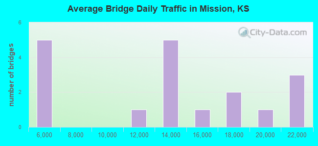
- 226,700Total average daily traffic
- 8,462Total average daily truck traffic
- National Bridge Inventory (NBI) Registered Bridges for Mission
- No street view available for this location
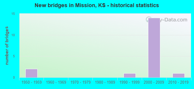
- New bridges - historical statistics
- 21950-1959
- 11990-1999
- 142000-2009
- 12010-2019
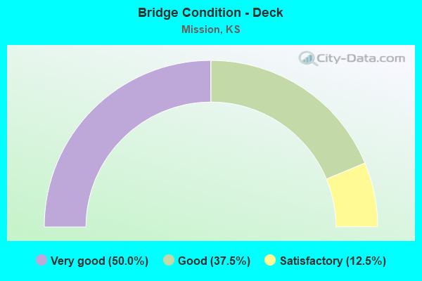
- Bridge Condition - Deck
- 50.0%Very good
- 37.5%Good
- 12.5%Satisfactory
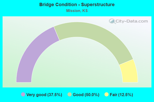
- Bridge Condition - Superstructure
- 37.5%Very good
- 50.0%Good
- 12.5%Fair
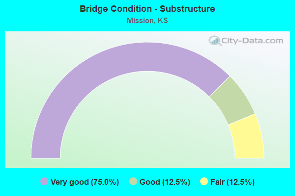
- Bridge Condition - Substructure
- 75.0%Very good
- 12.5%Good
- 12.5%Fair
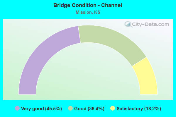
- Bridge Condition - Channel
- 45.5%Very good
- 36.4%Good
- 18.2%Satisfactory
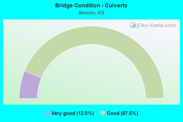
- Bridge Condition - Culverts
- 12.5%Very good
- 87.5%Good
Find on map >> Show street view
Structure Number: 419000463025018, Location: 200 FT. S. OF JOHNSON DR. (Lat: 39.024525, Lng: -94.639756), Route carried "on" structure: City street 3025, Year Built: 2007, Status: Open, Structure Length: 2.02m (6.63ft), Average Daily Traffic: 11,170 (year 2007), Truck Traffic: 15%, Average Future Daily Traffic: 11,170 (year 2041), Design Load: HS 20, Features Intersected: ROCK CREEK, Facility Carried by Structure: ROE AVE.
Minimum Vertical Clearance: 30.47m (99.97ft), Kilometerpoint: 0.000, Lanes on structure: 5, Owner: City or Municipal Highway Agency, Approaching Roadway Width: 19.2m (63.0ft), Skew: 20 degrees, Material/Design: Concrete, Design/Construction: Culvert, Number Of Spans In Main Unit: 5, Length of Maximum Span: 4.3m (14.1ft)
Condition: Channel: Very good, Culverts: Good, Operating Rating: 54.4 metric tons, Method Used To Determine Operating Rating: Field evaluation and documented engineering judgment, Inventory Rating: 32.7 metric tons, Method Used To Determine Inventory Rating: Field evaluation and documented engineering judgment, Structural Evaluation: Better than present minimum criteria, Waterway Adequacy: Equal to present desirable criteria, Approach Roadway Alignment: Equal to present desirable criteria, Designated Inspection Frequency: Every 24 months, Inspection Date: June 2021
Find on map >> Show street view
Structure Number: 519000460000012, Location: 300 FT. S. OF JOHNSON DR. (Lat: 39.021319, Lng: -94.652561), Route carried "on" structure: City street , Year Built: 1993, Status: Open, Structure Length: 0.63m (2.07ft), Average Daily Traffic: 4,518 (year 2007), Truck Traffic: 2%, Average Future Daily Traffic: 4,518 (year 2041), Design Load: HS 20, Features Intersected: ROCK CREEK, Facility Carried by Structure: OUTLOOK ST.
Minimum Vertical Clearance: 30.47m (99.97ft), Kilometerpoint: 0.000, Lanes on structure: 2, Owner: City or Municipal Highway Agency, Approaching Roadway Width: 8.2m (26.9ft), Material/Design: Concrete, Design/Construction: Culvert, Number Of Spans In Main Unit: 2, Length of Maximum Span: 3.0m (9.8ft)
Condition: Channel: Satisfactory, Culverts: Good, Operating Rating: 38.8 metric tons, Method Used To Determine Operating Rating: Load Factor (LF), Inventory Rating: 23.2 metric tons, Method Used To Determine Inventory Rating: Load Factor (LF), Structural Evaluation: Equal to present minimum criteria, Waterway Adequacy: Better than present minimum criteria, Approach Roadway Alignment: Equal to present desirable criteria, Designated Inspection Frequency: Every 24 months, Inspection Date: June 2021
Find on map >> Show street view
Structure Number: 519000460000013, Location: 150 FT. S. OF JOHNSON DR. (Lat: 39.021825, Lng: -94.651389), Route carried "on" structure: City street , Year Built: 1955, Status: Posted for load, Structure Length: 0.63m (2.07ft), Average Daily Traffic: 4,557 (year 2007), Truck Traffic: 2%, Average Future Daily Traffic: 4,557 (year 2041), Design Load: H 20, Features Intersected: ROCK CREEK, Facility Carried by Structure: REEDS DR.
Minimum Vertical Clearance: 30.47m (99.97ft), Kilometerpoint: 0.000, Lanes on structure: 2, Owner: City or Municipal Highway Agency, Approaching Roadway Width: 8.1m (26.6ft), Material/Design: Concrete, Design/Construction: Culvert, Number Of Spans In Main Unit: 2, Length of Maximum Span: 3.0m (9.8ft), Curb or Sidewalk Widths: Left: 1.2m (3.9ft), Right: 0.0m, Curb-To-Curb Width: 8.2m (26.9ft), Out-to-Out Width: 10.7m (35.1ft)
Condition: Channel: Good, Culverts: Good, Operating Rating: 30.1 metric tons, Method Used To Determine Operating Rating: Load Factor (LF), Inventory Rating: 18.1 metric tons, Method Used To Determine Inventory Rating: Load Factor (LF), Structural Evaluation: Somewhat better than minimum adequacy, Deck Geometry: High priority of corrective action, Waterway Adequacy: Better than present minimum criteria, Approach Roadway Alignment: Equal to present desirable criteria, Bridge Posting: Required (Relationship of Operating Rating to Maximum Legal Load: 0.1 - 9.9% below), Length Of Structure Improvement: 0.70m (2.30ft), Designated Inspection Frequency: Every 24 months, Inspection Date: June 2021, Bridge Improvement Cost: $220,000, Roadway Improvement Cost: $114,000, Total Project Cost: $340,000
Find on map >> Show street view
Structure Number: 519000460000015, Location: 40 FT. N. OF MARTWAY (Lat: 39.021656, Lng: -94.649072), Route carried "on" structure: City street , Year Built: 2006, Status: Open, Structure Length: 1.67m (5.48ft), Average Daily Traffic: 14,016 (year 2007), Truck Traffic: 2%, Average Future Daily Traffic: 14,016 (year 2041), Design Load: HS 20, Features Intersected: ROCK CREEK, Facility Carried by Structure: NALL AVE.
Minimum Vertical Clearance: 30.47m (99.97ft), Kilometerpoint: 0.000, Lanes on structure: 5, Owner: City or Municipal Highway Agency, Approaching Roadway Width: 16.7m (54.8ft), Skew: 20 degrees, Material/Design: Concrete, Design/Construction: Culvert, Number Of Spans In Main Unit: 4, Length of Maximum Span: 3.7m (12.1ft), Curb or Sidewalk Widths: Left: 1.5m (4.9ft), Right: 1.5m (4.9ft)
Condition: Channel: Good, Culverts: Good, Operating Rating: 54.4 metric tons, Method Used To Determine Operating Rating: Field evaluation and documented engineering judgment, Inventory Rating: 32.7 metric tons, Method Used To Determine Inventory Rating: Field evaluation and documented engineering judgment, Structural Evaluation: Better than present minimum criteria, Waterway Adequacy: Equal to present desirable criteria, Approach Roadway Alignment: Equal to present desirable criteria, Designated Inspection Frequency: Every 24 months, Inspection Date: June 2021
Find on map >> Show street view
Structure Number: 519000460000016, Location: 400 FT. E. OF NALL AVE. (Lat: 39.021544, Lng: -94.648144), Route carried "on" structure: City street , Year Built: 2006, Status: Open, Structure Length: 2.64m (8.66ft), Average Daily Traffic: 5,000 (year 2007), Truck Traffic: 5%, Average Future Daily Traffic: 5,000 (year 2041), Design Load: HS 20, Features Intersected: ROCK CREEK, Facility Carried by Structure: MARTWAY
Minimum Vertical Clearance: 30.47m (99.97ft), Kilometerpoint: 0.000, Lanes on structure: 3, Owner: City or Municipal Highway Agency, Approaching Roadway Width: 12.6m (41.3ft), Skew: 7 degrees, Material/Design: Concrete, Design/Construction: Culvert, Number Of Spans In Main Unit: 4, Length of Maximum Span: 5.8m (19.0ft), Curb or Sidewalk Widths: Left: 3.0m (9.8ft), Right: 1.5m (4.9ft)
Condition: Channel: Good, Culverts: Good, Operating Rating: 54.4 metric tons, Method Used To Determine Operating Rating: Field evaluation and documented engineering judgment, Inventory Rating: 32.7 metric tons, Method Used To Determine Inventory Rating: Field evaluation and documented engineering judgment, Structural Evaluation: Better than present minimum criteria, Waterway Adequacy: Equal to present desirable criteria, Approach Roadway Alignment: Equal to present desirable criteria, Designated Inspection Frequency: Every 24 months, Inspection Date: June 2021
Find on map >> Show street view
Structure Number: 519000460000017, Location: 100 FT. S. OF MARTWAY (Lat: 39.022664, Lng: -94.642758), Route carried "on" structure: City street , Year Built: 2008, Status: Open, Structure Length: 1.43m (4.69ft), Average Daily Traffic: 5,600 (year 2007), Truck Traffic: 2%, Average Future Daily Traffic: 5,600 (year 2041), Design Load: HS 20, Features Intersected: ROCK CREEK, Facility Carried by Structure: ROELAND DR.
Minimum Vertical Clearance: 30.47m (99.97ft), Kilometerpoint: 0.000, Lanes on structure: 3, Owner: City or Municipal Highway Agency, Approaching Roadway Width: 10.6m (34.8ft), Material/Design: Concrete, Design/Construction: Culvert, Number Of Spans In Main Unit: 3, Length of Maximum Span: 4.3m (14.1ft), Curb or Sidewalk Widths: Left: 1.8m (5.9ft), Right: 0.0m
Condition: Channel: Very good, Culverts: Good, Operating Rating: 54.4 metric tons, Method Used To Determine Operating Rating: Field evaluation and documented engineering judgment, Inventory Rating: 32.7 metric tons, Method Used To Determine Inventory Rating: Field evaluation and documented engineering judgment, Structural Evaluation: Better than present minimum criteria, Waterway Adequacy: Equal to present desirable criteria, Approach Roadway Alignment: Equal to present desirable criteria, Designated Inspection Frequency: Every 24 months, Inspection Date: June 2021
Find on map >> Show street view
Structure Number: 519000460000019, Location: 20 FT. S. OF 1-35 (Lat: 39.044053, Lng: -94.656122), Route carried "on" structure: City street , Year Built: 2004, Status: Open, Structure Length: 5.58m (18.31ft), Average Daily Traffic: 18,100 (year 2007), Truck Traffic: 2%, Average Future Daily Traffic: 20,400 (year 2041), Design Load: HS 25 or greater, Features Intersected: TURKEY CREEK, Facility Carried by Structure: LAMAR AVE.
Minimum Vertical Clearance: 30.47m (99.97ft), Kilometerpoint: 0.000, Lanes on structure: 4, Owner: City or Municipal Highway Agency, Approaching Roadway Width: 16.7m (54.8ft), Skew: 1 degrees, Material/Design: Concrete continuous, Design/Construction: Slab, Number Of Spans In Main Unit: 3, Length of Maximum Span: 22.0m (72.2ft), Curb-To-Curb Width: 16.8m (55.1ft), Out-to-Out Width: 17.4m (57.1ft)
Condition: Deck: Good, Superstructure: Good, Substructure: Good, Channel: Satisfactory, Operating Rating: 96.5 metric tons, Method Used To Determine Operating Rating: Load Factor (LF), Inventory Rating: 57.8 metric tons, Method Used To Determine Inventory Rating: Load Factor (LF), Structural Evaluation: Better than present minimum criteria, Deck Geometry: Somewhat better than minimum adequacy, Waterway Adequacy: Equal to present desirable criteria, Approach Roadway Alignment: Equal to present desirable criteria, Designated Inspection Frequency: Every 24 months, Inspection Date: June 2021, Deck Structure Type: Concrete Cast-file-Place, Wearing Surface/Protective System: Deck Protection: Epoxy Coated Reinforcing
Find on map >> Show street view
Structure Number: 51900046000002, Location: INT OF JOHNSON & ROELAND (Lat: 39.024036, Lng: -94.643619), Route carried "on" structure: City street , Year Built: 2007, Status: Open, Structure Length: 1.35m (4.43ft), Average Daily Traffic: 13,095 (year 2008), Truck Traffic: 5%, Average Future Daily Traffic: 13,095 (year 2041), Design Load: HS 20, Features Intersected: COOPER CREEK, Facility Carried by Structure: JOHNSON DR.
Minimum Vertical Clearance: 30.47m (99.97ft), Kilometerpoint: 0.000, Lanes on structure: 4, Owner: City or Municipal Highway Agency, Approaching Roadway Width: 15.2m (49.9ft), Skew: 6 degrees, Material/Design: Concrete, Design/Construction: Culvert, Number Of Spans In Main Unit: 2, Length of Maximum Span: 6.7m (22.0ft)
Condition: Channel: Very good, Culverts: Good, Operating Rating: 54.4 metric tons, Method Used To Determine Operating Rating: Field evaluation and documented engineering judgment, Inventory Rating: 32.7 metric tons, Method Used To Determine Inventory Rating: Field evaluation and documented engineering judgment, Structural Evaluation: Better than present minimum criteria, Waterway Adequacy: Equal to present desirable criteria, Approach Roadway Alignment: Equal to present desirable criteria, Designated Inspection Frequency: Every 24 months, Inspection Date: June 2021
Find on map >> Show street view
Structure Number: 519000460000021, Location: Woodson and Martway inter (Lat: 39.019933, Lng: -94.654017), Route carried "on" structure: City street , Year Built: 2013, Status: Open, Structure Length: 1.16m (3.81ft), Average Daily Traffic: 5,277 (year 2007), Truck Traffic: 2%, Average Future Daily Traffic: 5,277 (year 2041), Design Load: HS 20, Features Intersected: ROCK CREEK, Facility Carried by Structure: MARTWAY
Minimum Vertical Clearance: 30.47m (99.97ft), Kilometerpoint: 0.000, Lanes on structure: 2, Owner: City or Municipal Highway Agency, Approaching Roadway Width: 8.2m (26.9ft), Skew: 5 degrees, Material/Design: Concrete, Design/Construction: Culvert, Number Of Spans In Main Unit: 2, Length of Maximum Span: 5.3m (17.4ft), Curb or Sidewalk Widths: Left: 1.8m (5.9ft), Right: 3.0m (9.8ft)
Condition: Channel: Very good, Culverts: Very good, Operating Rating: 53.1 metric tons, Method Used To Determine Operating Rating: Load and Resistance Factor Rating (LRFR) rating reported by rating factor(RF) method using HL-93 loadings, Inventory Rating: 40.8 metric tons, Method Used To Determine Inventory Rating: Load and Resistance Factor Rating (LRFR) rating reported by rating factor(RF) method using HL-93 loadings, Structural Evaluation: Equal to present desirable criteria, Waterway Adequacy: Better than present minimum criteria, Approach Roadway Alignment: Better than present minimum criteria, Designated Inspection Frequency: Every 24 months, Inspection Date: June 2021
Find on map >> Show street view
Structure Number: 999905600463261, Location: E JCT U56/U69/METCALF (Lat: 39.014722, Lng: -94.667500), Route carried "on" structure: US 56, Year Built: 2001, Status: Open, Structure Length: 6.08m (19.95ft), Average Daily Traffic: 17,880 (year 2020), Truck Traffic: 3%, Average Future Daily Traffic: 20,557 (year 2041), Design Load: HS 20+Mod, Features Intersected: U69/METCALF
Minimum Vertical Clearance: 30.47m (99.97ft), Kilometerpoint: 48.676, Lanes on structure: 3, Lanes under structure: 6, Base Highway Network: Yes, Owner: State Highway Agency, Approaching Roadway Width: 13.1m (43.0ft), Skew: 10 degrees, Material/Design: Steel continuous, Design/Construction: Stringer/Multi-beam, Number Of Spans In Main Unit: 4, Length of Maximum Span: 18.5m (60.7ft), Curb-To-Curb Width: 12.3m (40.4ft), Out-to-Out Width: 13.5m (44.3ft)
Condition: Deck: Good, Superstructure: Good, Substructure: Very good, Operating Rating: 35.7 metric tons, Method Used To Determine Operating Rating: Load Factor (LF), Inventory Rating: 21.4 metric tons, Method Used To Determine Inventory Rating: Load Factor (LF), Structural Evaluation: Somewhat better than minimum adequacy, Deck Geometry: Meets minimum limits, Underclear: Somewhat better than minimum adequacy, Approach Roadway Alignment: Better than present minimum criteria, Length Of Structure Improvement: 19.95m (65.45ft), Designated Inspection Frequency: Every 24 months, Inspection Date: May 2020, Wearing Surface/Protective System: Wearing Surface: Low Slump Concrete, Deck Protection: Epoxy Coated Reinforcing
Find on map >> Show street view
Structure Number: 999905600463271, Location: EJCT U56/U69/METCALF (Lat: 39.015000, Lng: -94.667500), Route carried "on" structure: US 56, Year Built: 2001, Status: Open, Structure Length: 6.08m (19.95ft), Average Daily Traffic: 17,880 (year 2020), Truck Traffic: 3%, Average Future Daily Traffic: 21,389 (year 2041), Design Load: HS 20+Mod, Features Intersected: U69/METCALF
Minimum Vertical Clearance: 30.47m (99.97ft), Kilometerpoint: 48.097, Lanes on structure: 3, Lanes under structure: 6, Base Highway Network: Yes, Owner: State Highway Agency, Approaching Roadway Width: 13.1m (43.0ft), Skew: 10 degrees, Material/Design: Steel continuous, Design/Construction: Stringer/Multi-beam, Number Of Spans In Main Unit: 4, Length of Maximum Span: 18.5m (60.7ft), Curb-To-Curb Width: 12.3m (40.4ft), Out-to-Out Width: 13.5m (44.3ft)
Condition: Deck: Very good, Superstructure: Good, Substructure: Very good, Operating Rating: 39.3 metric tons, Method Used To Determine Operating Rating: Load Factor (LF), Inventory Rating: 23.5 metric tons, Method Used To Determine Inventory Rating: Load Factor (LF), Structural Evaluation: Somewhat better than minimum adequacy, Deck Geometry: Meets minimum limits, Underclear: Somewhat better than minimum adequacy, Approach Roadway Alignment: Better than present minimum criteria, Length Of Structure Improvement: 19.95m (65.45ft), Designated Inspection Frequency: Every 24 months, Inspection Date: May 2020, Wearing Surface/Protective System: Wearing Surface: Low Slump Concrete, Deck Protection: Epoxy Coated Reinforcing
Find on map >> Show street view
Structure Number: 999905600463281, Location: JCT ROE AVE/US-56 SL (Lat: 39.023056, Lng: -94.639444), Route carried "on" structure: US 56, Year Built: 2000, Status: Open, Structure Length: 7.58m (24.87ft), Average Daily Traffic: 12,173 (year 2020), Truck Traffic: 4%, Average Future Daily Traffic: 13,995 (year 2041), Design Load: HS 20, Features Intersected: URB3025, ROE AVE
Minimum Vertical Clearance: 30.47m (99.97ft), Kilometerpoint: 51.451, Lanes on structure: 2, Lanes under structure: 4, Base Highway Network: Yes, Owner: State Highway Agency, Approaching Roadway Width: 15.5m (50.9ft), Skew: 5 degrees, Material/Design: Steel continuous, Design/Construction: Stringer/Multi-beam, Number Of Spans In Main Unit: 4, Length of Maximum Span: 22.3m (73.2ft), Curb-To-Curb Width: 15.5m (50.9ft), Out-to-Out Width: 15.9m (52.2ft)
Condition: Deck: Good, Superstructure: Very good, Substructure: Very good, Operating Rating: 76.7 metric tons, Method Used To Determine Operating Rating: Load Factor (LF), Inventory Rating: 45.9 metric tons, Method Used To Determine Inventory Rating: Load Factor (LF), Structural Evaluation: Equal to present desirable criteria, Deck Geometry: Superior to present desirable criteria, Underclear: Meets minimum limits, Approach Roadway Alignment: Equal to present desirable criteria, Length Of Structure Improvement: 24.86m (81.56ft), Designated Inspection Frequency: Every 24 months, Inspection Date: May 2020, Wearing Surface/Protective System: Wearing Surface: Low Slump Concrete, Deck Protection: Epoxy Coated Reinforcing
Find on map >> Show street view
Structure Number: 999905600463291, Location: JCT ROE AVE/US-56 WB (Lat: 39.023056, Lng: -94.639722), Route carried "on" structure: US 56, Year Built: 2000, Status: Open, Structure Length: 7.58m (24.87ft), Average Daily Traffic: 12,173 (year 2020), Truck Traffic: 4%, Average Future Daily Traffic: 13,995 (year 2041), Design Load: HS 20, Features Intersected: ROE AVE
Minimum Vertical Clearance: 30.47m (99.97ft), Kilometerpoint: 50.875, Lanes on structure: 2, Lanes under structure: 4, Base Highway Network: Yes, Owner: State Highway Agency, Approaching Roadway Width: 12.5m (41.0ft), Skew: 5 degrees, Material/Design: Steel continuous, Design/Construction: Stringer/Multi-beam, Number Of Spans In Main Unit: 4, Length of Maximum Span: 22.3m (73.2ft), Curb-To-Curb Width: 12.5m (41.0ft), Out-to-Out Width: 12.9m (42.3ft)
Condition: Deck: Very good, Superstructure: Very good, Substructure: Very good, Operating Rating: 82.4 metric tons, Method Used To Determine Operating Rating: Load Factor (LF), Inventory Rating: 49.4 metric tons, Method Used To Determine Inventory Rating: Load Factor (LF), Structural Evaluation: Equal to present desirable criteria, Deck Geometry: Better than present minimum criteria, Underclear: Meets minimum limits, Approach Roadway Alignment: Equal to present desirable criteria, Length Of Structure Improvement: 24.86m (81.56ft), Designated Inspection Frequency: Every 24 months, Inspection Date: May 2020, Wearing Surface/Protective System: Wearing Surface: Low Slump Concrete, Deck Protection: Epoxy Coated Reinforcing
Find on map >> Show street view
Structure Number: 999905600463301, Location: US-56 OVER JOHNSON DR (Lat: 39.024167, Lng: -94.638056), Route carried "on" structure: US 56, Year Built: 2000, Status: Open, Structure Length: 5.93m (19.46ft), Average Daily Traffic: 12,173 (year 2020), Truck Traffic: 4%, Average Future Daily Traffic: 13,995 (year 2041), Design Load: HS 20, Features Intersected: JO DR/BRUSH CK DR/US56
Minimum Vertical Clearance: 30.47m (99.97ft), Kilometerpoint: 51.641, Lanes on structure: 2, Lanes under structure: 2, Base Highway Network: Yes, Owner: State Highway Agency, Approaching Roadway Width: 15.5m (50.9ft), Skew: 2 degrees, Material/Design: Steel continuous, Design/Construction: Stringer/Multi-beam, Number Of Spans In Main Unit: 4, Length of Maximum Span: 20.0m (65.6ft), Curb-To-Curb Width: 15.5m (50.9ft), Out-to-Out Width: 15.9m (52.2ft)
Condition: Deck: Very good, Superstructure: Good, Substructure: Very good, Channel: Good, Operating Rating: 70.8 metric tons, Method Used To Determine Operating Rating: Load Factor (LF), Inventory Rating: 42.4 metric tons, Method Used To Determine Inventory Rating: Load Factor (LF), Structural Evaluation: Better than present minimum criteria, Deck Geometry: Superior to present desirable criteria, Underclear: High priority of corrective action, Waterway Adequacy: Equal to present desirable criteria, Approach Roadway Alignment: Equal to present desirable criteria, Length Of Structure Improvement: 19.47m (63.88ft), Designated Inspection Frequency: Every 24 months, Inspection Date: May 2020, Wearing Surface/Protective System: Wearing Surface: Low Slump Concrete, Deck Protection: Epoxy Coated Reinforcing
Find on map >> Show street view
Structure Number: 999905600463311, Location: 56 OVER JO DR (Lat: 39.024444, Lng: -94.638333), Route carried "on" structure: US 56, Year Built: 2001, Status: Open, Structure Length: 5.93m (19.46ft), Average Daily Traffic: 12,173 (year 2020), Truck Traffic: 4%, Average Future Daily Traffic: 13,995 (year 2041), Design Load: HS 20, Features Intersected: JOHNSON DR/BRUSH CR DRG
Minimum Vertical Clearance: 30.47m (99.97ft), Kilometerpoint: 51.040, Lanes on structure: 2, Lanes under structure: 2, Base Highway Network: Yes, Owner: State Highway Agency, Approaching Roadway Width: 12.5m (41.0ft), Skew: 2 degrees, Material/Design: Steel continuous, Design/Construction: Stringer/Multi-beam, Number Of Spans In Main Unit: 4, Length of Maximum Span: 20.0m (65.6ft), Curb-To-Curb Width: 12.5m (41.0ft), Out-to-Out Width: 12.9m (42.3ft)
Condition: Deck: Very good, Superstructure: Very good, Substructure: Very good, Channel: Very good, Operating Rating: 75.5 metric tons, Method Used To Determine Operating Rating: Load Factor (LF), Inventory Rating: 45.2 metric tons, Method Used To Determine Inventory Rating: Load Factor (LF), Structural Evaluation: Equal to present desirable criteria, Deck Geometry: Better than present minimum criteria, Underclear: High priority of corrective action, Waterway Adequacy: Equal to present desirable criteria, Approach Roadway Alignment: Equal to present desirable criteria, Length Of Structure Improvement: 19.47m (63.88ft), Designated Inspection Frequency: Every 24 months, Inspection Date: May 2020, Wearing Surface/Protective System: Wearing Surface: Low Slump Concrete, Deck Protection: Epoxy Coated Reinforcing
Find on map >> Show street view
Structure Number: 999906900461191, Location: JCT.OLD K158/U69HWY (Lat: 39.022222, Lng: -94.667500), Route carried "on" structure: US 69, Year Built: 1955, Status: Open, Structure Length: 4.26m (13.98ft), Average Daily Traffic: 20,305 (year 2020), Truck Traffic: 3%, Average Future Daily Traffic: 25,776 (year 2041), Design Load: HS 20, Features Intersected: URB2712, JOHNSON DR
Minimum Vertical Clearance: 30.47m (99.97ft), Kilometerpoint: 35.855, Lanes on structure: 4, Lanes under structure: 4, Base Highway Network: Yes, Owner: State Highway Agency, Approaching Roadway Width: 17.1m (56.1ft), Skew: 20 degrees, Material/Design: Concrete continuous, Design/Construction: Slab, Number Of Spans In Main Unit: 3, Length of Maximum Span: 16.8m (55.1ft), Curb-To-Curb Width: 17.1m (56.1ft), Out-to-Out Width: 18.4m (60.4ft)
Condition: Deck: Satisfactory, Superstructure: Fair, Substructure: Fair, Operating Rating: 46.3 metric tons, Method Used To Determine Operating Rating: Load Factor (LF), Inventory Rating: 28.1 metric tons, Method Used To Determine Inventory Rating: Load Factor (LF), Structural Evaluation: Somewhat better than minimum adequacy, Deck Geometry: High priority of corrective action, Underclear: High priority of corrective action, Approach Roadway Alignment: Equal to present minimum criteria, Length Of Structure Improvement: 13.99m (45.90ft), Designated Inspection Frequency: Every 24 months, Inspection Date: May 2020, Deck Structure Type: Concrete Cast-file-Place, Wearing Surface/Protective System: Wearing Surface: Low Slump Concrete
Find on map >> Show street view
Structure Number: 999905600463261, Location: E JCT U56/U69/METCALF (Lat: 39.014722, Lng: -94.667500), Route carried "under" structure: US 69, Year Built: 2001, Structure Length: 0. m, Average Daily Traffic: 20,305 (year 2020), Truck Traffic: 3%, Features Intersected: U69/METCALF, Facility Carried by Structure: U56 HWY EB
Minimum Vertical Clearance: 5.02m (16.47ft), Kilometerpoint: 0.027, Lanes on structure: 3, Lanes under structure: 6, Material/Design: Steel continuous, Design/Construction: Stringer/Multi-beam, Length of Maximum Span: 18.5m (60.7ft)
Find on map >> Show street view
Structure Number: 999905600463271, Location: EJCT U56/U69/METCALF (Lat: 39.015000, Lng: -94.667500), Route carried "under" structure: US 69, Year Built: 2001, Structure Length: 0. m, Average Daily Traffic: 20,305 (year 2020), Truck Traffic: 3%, Features Intersected: U69/METCALF, Facility Carried by Structure: U56 HWY WB
Minimum Vertical Clearance: 5.05m (16.57ft), Kilometerpoint: 35.050, Lanes on structure: 3, Lanes under structure: 6, Material/Design: Steel continuous, Design/Construction: Stringer/Multi-beam, Length of Maximum Span: 18.5m (60.7ft)