Bridge Statistics for Mitchellville, Maryland (MD)
Condition, Traffic, Stress, Structural Evaluation, Project Costs
- National Bridge Inventory (NBI) Statistics
- 11Number of bridges
- 79ft / 23.6mTotal length
- $714,000Total costs
- 666,914Total average daily traffic
- 50,764Total average daily truck traffic
- National Bridge Inventory (NBI) Registered Bridges for Mitchellville
- No street view available for this location
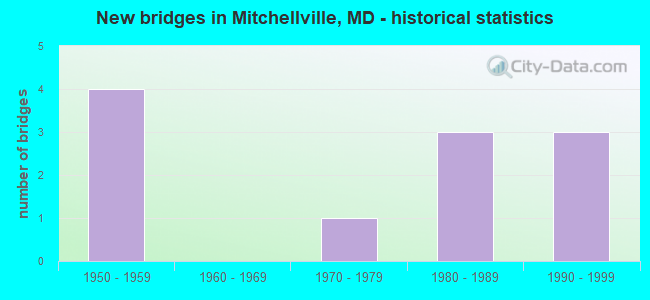
- New bridges - historical statistics
- 41950-1959
- 11970-1979
- 31980-1989
- 31990-1999
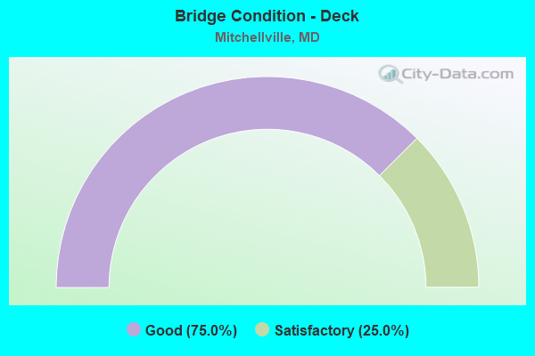
- Bridge Condition - Deck
- 75.0%Good
- 25.0%Satisfactory
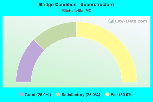
- Bridge Condition - Superstructure
- 25.0%Good
- 25.0%Satisfactory
- 50.0%Fair
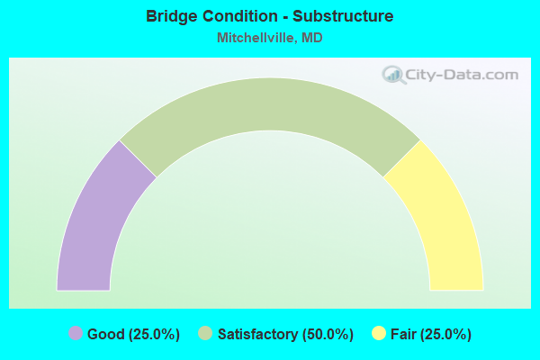
- Bridge Condition - Substructure
- 25.0%Good
- 50.0%Satisfactory
- 25.0%Fair
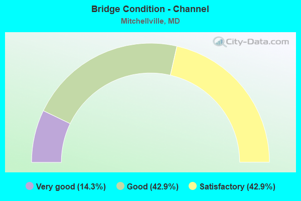
- Bridge Condition - Channel
- 14.3%Very good
- 42.9%Good
- 42.9%Satisfactory
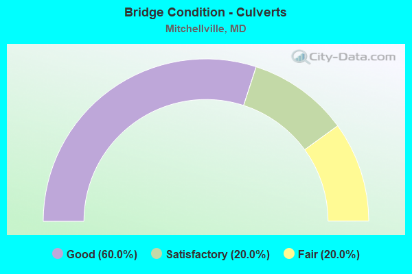
- Bridge Condition - Culverts
- 60.0%Good
- 20.0%Satisfactory
- 20.0%Fair
Find on map >> Show street view
Structure Number: 10000016007502, Location: 0.05 MILE WEST OF MD 214 (Lat: 38.900881, Lng: -76.793067), Route carried "on" structure: State highway 193, Year Built: 1988, Status: Open, Structure Length: 1.16m (3.81ft), Average Daily Traffic: 15,720 (year 2009), Truck Traffic: 8%, Average Future Daily Traffic: 17,387 (year 2026), Design Load: HS 20, Features Intersected: NORTHEAST BRANCH
Minimum Vertical Clearance: 30+ m (98+ ft), Kilometerpoint: 27.778, Lanes on structure: 6, Owner: State Highway Agency, Approaching Roadway Width: 21.9m (71.9ft), Skew: 1 degrees, Material/Design: Concrete, Design/Construction: Culvert, Length of Maximum Span: 5.5m (18.0ft)
Condition: Channel: Good, Culverts: Satisfactory, Operating Rating: 32.7 metric tons, Method Used To Determine Operating Rating: Field evaluation and documented engineering judgment, Inventory Rating: 32.7 metric tons, Method Used To Determine Inventory Rating: Field evaluation and documented engineering judgment, Structural Evaluation: Equal to present minimum criteria, Waterway Adequacy: Better than present minimum criteria, Approach Roadway Alignment: Equal to present minimum criteria, Designated Inspection Frequency: Every 24 months, Other Special Inspection Frequency: Every 12 months, Inspection Date: May 2020, Other Special Inspection Date: May 2021
Find on map >> Show street view
Structure Number: 100000160089013, Location: 2.52 MILES EAST OF MD 704 (Lat: 38.944164, Lng: -76.798831), Route carried "on" structure: Interstate 595, Year Built: 1955, Year Reconstructed: 1985, Status: Open, Structure Length: 5.49m (18.01ft), Average Daily Traffic: 124,950 (year 2012), Truck Traffic: 8%, Average Future Daily Traffic: 169,210 (year 2029), Design Load: HS 20, Features Intersected: MD 193
Minimum Vertical Clearance: 30+ m (98+ ft), Kilometerpoint: 5.665, Lanes on structure: 3, Lanes under structure: 2, Base Highway Network: Yes, Owner: State Highway Agency, Approaching Roadway Width: 17.4m (57.1ft), Material/Design: Steel, Design/Construction: Stringer/Multi-beam, Number Of Spans In Main Unit: 4, Length of Maximum Span: 16.8m (55.1ft), Curb-To-Curb Width: 17.4m (57.1ft), Out-to-Out Width: 18.3m (60.0ft)
Condition: Deck: Good, Superstructure: Fair, Substructure: Satisfactory, Operating Rating: 73.9 metric tons, Method Used To Determine Operating Rating: Load Factor (LF), Inventory Rating: 44.0 metric tons, Method Used To Determine Inventory Rating: Load Factor (LF), Structural Evaluation: Somewhat better than minimum adequacy, Deck Geometry: Better than present minimum criteria, Underclear: Better than present minimum criteria, Approach Roadway Alignment: Equal to present desirable criteria, Length Of Structure Improvement: 5.49m (18.01ft), Designated Inspection Frequency: Every 24 months, Inspection Date: July 2020, Bridge Improvement Cost: $649,000, Roadway Improvement Cost: $65,000, Total Project Cost: $714,000, Deck Structure Type: Concrete Cast-file-Place, Wearing Surface/Protective System: Wearing Surface: Monolithic Concrete, Deck Protection: Epoxy Coated Reinforcing
Find on map >> Show street view
Structure Number: 100000160090013, Location: 1.11 MILES WEST OF MD 193 (Lat: 38.946667, Lng: -76.818847), Route carried "on" structure: Interstate 595, Year Built: 1955, Year Reconstructed: 1985, Status: Open, Structure Length: 2.59m (8.50ft), Average Daily Traffic: 113,590 (year 2009), Truck Traffic: 8%, Average Future Daily Traffic: 169,210 (year 2029), Design Load: HS 20, Features Intersected: FOLLY BRANCH
Minimum Vertical Clearance: 30+ m (98+ ft), Kilometerpoint: 3.873, Lanes on structure: 3, Base Highway Network: Yes, Owner: State Highway Agency, Approaching Roadway Width: 17.4m (57.1ft), Material/Design: Steel, Design/Construction: Stringer/Multi-beam, Number Of Spans In Main Unit: 3, Length of Maximum Span: 8.2m (26.9ft), Curb-To-Curb Width: 17.4m (57.1ft), Out-to-Out Width: 18.3m (60.0ft)
Condition: Deck: Satisfactory, Superstructure: Satisfactory, Substructure: Satisfactory, Channel: Good, Inventory Rating: 70.3 metric tons, Method Used To Determine Inventory Rating: Load Factor (LF), Structural Evaluation: Equal to present minimum criteria, Deck Geometry: Better than present minimum criteria, Waterway Adequacy: Equal to present desirable criteria, Approach Roadway Alignment: Equal to present desirable criteria, Designated Inspection Frequency: Every 24 months, Inspection Date: August 2020, Deck Structure Type: Concrete Cast-file-Place, Wearing Surface/Protective System: Wearing Surface: Monolithic Concrete, Deck Protection: Epoxy Coated Reinforcing
Find on map >> Show street view
Structure Number: 100000160090014, Location: 1.11 MILES WEST OF MD 193 (Lat: 38.946889, Lng: -76.818525), Route carried "on" structure: Interstate 595, Year Built: 1955, Year Reconstructed: 1985, Status: Open, Structure Length: 2.59m (8.50ft), Average Daily Traffic: 113,590 (year 2009), Truck Traffic: 8%, Average Future Daily Traffic: 169,210 (year 2029), Design Load: HS 20, Features Intersected: FOLLY BRANCH
Minimum Vertical Clearance: 30+ m (98+ ft), Kilometerpoint: 3.873, Lanes on structure: 3, Base Highway Network: Yes, Owner: State Highway Agency, Approaching Roadway Width: 17.4m (57.1ft), Material/Design: Steel, Design/Construction: Stringer/Multi-beam, Number Of Spans In Main Unit: 3, Length of Maximum Span: 8.2m (26.9ft), Curb-To-Curb Width: 17.4m (57.1ft), Out-to-Out Width: 18.3m (60.0ft)
Condition: Deck: Good, Superstructure: Fair, Substructure: Fair, Channel: Good, Operating Rating: 75.3 metric tons, Method Used To Determine Operating Rating: Load Factor (LF), Inventory Rating: 44.9 metric tons, Method Used To Determine Inventory Rating: Load Factor (LF), Structural Evaluation: Somewhat better than minimum adequacy, Deck Geometry: Better than present minimum criteria, Waterway Adequacy: Superior to present desirable criteria, Approach Roadway Alignment: Equal to present desirable criteria, Designated Inspection Frequency: Every 24 months, Inspection Date: August 2020, Deck Structure Type: Concrete Cast-file-Place, Wearing Surface/Protective System: Wearing Surface: Monolithic Concrete, Deck Protection: Epoxy Coated Reinforcing
Find on map >> Show street view
Structure Number: 10000016009101, Location: 0.13 M S OF FORBES BL'VD (Lat: 38.947400, Lng: -76.825703), Route carried "on" structure: State highway 950C, Year Built: 1991, Status: Open, Structure Length: 7.19m (23.59ft), Average Daily Traffic: 9,450 (year 2009), Truck Traffic: 8%, Average Future Daily Traffic: 10,089 (year 2026), Design Load: HS 20, Features Intersected: IS 595
Minimum Vertical Clearance: 30+ m (98+ ft), Kilometerpoint: 0.998, Lanes on structure: 2, Lanes under structure: 7, Owner: State Highway Agency, Approaching Roadway Width: 13.4m (44.0ft), Material/Design: Steel, Design/Construction: Stringer/Multi-beam, Number Of Spans In Main Unit: 2, Length of Maximum Span: 35.4m (116.1ft), Curb-To-Curb Width: 13.4m (44.0ft), Out-to-Out Width: 14.6m (47.9ft)
Condition: Deck: Good, Superstructure: Good, Substructure: Good, Operating Rating: 53.1 metric tons, Method Used To Determine Operating Rating: Load Factor (LF), Inventory Rating: 31.7 metric tons, Method Used To Determine Inventory Rating: Load Factor (LF), Structural Evaluation: Better than present minimum criteria, Deck Geometry: Equal to present minimum criteria, Underclear: Somewhat better than minimum adequacy, Approach Roadway Alignment: Equal to present desirable criteria, Designated Inspection Frequency: Every 24 months, Inspection Date: October 2020, Deck Structure Type: Concrete Cast-file-Place, Wearing Surface/Protective System: Wearing Surface: Integral Concrete, Membrane: Built-up, Deck Protection: Epoxy Coated Reinforcing
Find on map >> Show street view
Structure Number: 10000016018302, Location: 0.56 MILE WEST OF MD 193 (Lat: 38.945861, Lng: -76.808297), Route carried "on" structure: Interstate 595, Year Built: 1988, Status: Open, Structure Length: 0.61m (2.00ft), Average Daily Traffic: 123,200 (year 2006), Truck Traffic: 8%, Average Future Daily Traffic: 133,056 (year 2026), Design Load: HS 20, Features Intersected: LOTTSFORD BRANCH
Minimum Vertical Clearance: 30+ m (98+ ft), Kilometerpoint: 4.825, Lanes on structure: 6, Base Highway Network: Yes, Owner: State Highway Agency, Approaching Roadway Width: 34.1m (111.9ft), Material/Design: Concrete, Design/Construction: Culvert, Length of Maximum Span: 6.1m (20.0ft)
Condition: Channel: Satisfactory, Culverts: Good, Structural Evaluation: Better than present minimum criteria, Waterway Adequacy: Better than present minimum criteria, Approach Roadway Alignment: Equal to present desirable criteria, Designated Inspection Frequency: Every 24 months, Underwater Inspection Frequency: Every 48 months, Inspection Date: May 2020, Underwater Inspection Date: December 2020
Find on map >> Show street view
Structure Number: 10000016021603, Location: 0.54 MILE WEST OF MD 193 (Lat: 38.947439, Lng: -76.807761), Route carried "on" structure: State highway 953, Year Built: 1984, Status: Open, Structure Length: 1.07m (3.51ft), Average Daily Traffic: 3,740 (year 2009), Truck Traffic: 8%, Average Future Daily Traffic: 4,220 (year 2026), Design Load: HS 20, Features Intersected: LOTTSFORD BRANCH
Minimum Vertical Clearance: 30+ m (98+ ft), Kilometerpoint: 0.869, Lanes on structure: 4, Owner: State Highway Agency, Approaching Roadway Width: 15.9m (52.2ft), Material/Design: Steel, Design/Construction: Culvert, Length of Maximum Span: 3.0m (9.8ft)
Condition: Channel: Satisfactory, Culverts: Good, Structural Evaluation: Better than present minimum criteria, Waterway Adequacy: Better than present minimum criteria, Approach Roadway Alignment: Equal to present desirable criteria, Designated Inspection Frequency: Every 24 months, Inspection Date: Febuary 2020
Find on map >> Show street view
Structure Number: 10000016025802, Location: 0.19 M E OF ATWELL AVE (Lat: 38.957256, Lng: -76.806164), Route carried "on" structure: State highway 450, Year Built: 1999, Status: Open, Structure Length: 0.98m (3.22ft), Average Daily Traffic: 27,830 (year 2012), Truck Traffic: 4%, Average Future Daily Traffic: 37,571 (year 2032), Design Load: HS 25 or greater, Features Intersected: LOTTSFORD BRANCH
Minimum Vertical Clearance: 30+ m (98+ ft), Kilometerpoint: 13.290, Lanes on structure: 6, Base Highway Network: Yes, Owner: State Highway Agency, Approaching Roadway Width: 32.9m (107.9ft), Skew: 21 degrees, Material/Design: Concrete, Design/Construction: Culvert, Length of Maximum Span: 4.6m (15.1ft), Curb or Sidewalk Widths: Left: 2.4m (7.9ft), Right: 0.0m
Condition: Channel: Very good, Culverts: Good, Operating Rating: 32.7 metric tons, Method Used To Determine Operating Rating: Field evaluation and documented engineering judgment, Inventory Rating: 32.7 metric tons, Method Used To Determine Inventory Rating: Field evaluation and documented engineering judgment, Structural Evaluation: Better than present minimum criteria, Waterway Adequacy: Equal to present desirable criteria, Approach Roadway Alignment: Equal to present desirable criteria, Designated Inspection Frequency: Every 24 months, Inspection Date: March 2021, Deck Structure Type: Concrete Cast-file-Place
Find on map >> Show street view
Structure Number: 200000P-027403, Location: 0.63 MI WEST OF MD 193 (Lat: 38.942592, Lng: -76.811322), Route carried "on" structure: County highway 3131, Year Built: 1979, Status: Open, Structure Length: 1.92m (6.30ft), Average Daily Traffic: 2,264 (year 2019), Truck Traffic: 10%, Average Future Daily Traffic: 2,763 (year 2039), Features Intersected: LOTTSFORD BRANCH, Facility Carried by Structure: CHANTILLY LANE
Minimum Vertical Clearance: 30+ m (98+ ft), Kilometerpoint: 0.274, Lanes on structure: 2, Owner: County Highway Agency, Approaching Roadway Width: 11.0m (36.1ft), Skew: 1 degrees, Material/Design: Aluminum, Iron, Design/Construction: Culvert, Number Of Spans In Main Unit: 3, Length of Maximum Span: 5.8m (19.0ft)
Condition: Channel: Satisfactory, Culverts: Fair, Inventory Rating: 78.9 metric tons, Method Used To Determine Inventory Rating: Load Factor (LF), Structural Evaluation: Somewhat better than minimum adequacy, Waterway Adequacy: Better than present minimum criteria, Approach Roadway Alignment: Equal to present desirable criteria, Length Of Structure Improvement: 3.66m (12.01ft), Designated Inspection Frequency: Every 24 months, Inspection Date: Febuary 2021
Find on map >> Show street view
Structure Number: 100000160089013, Location: 1.18 MILES EAST OF MD 450 (Lat: 38.944164, Lng: -76.798831), Route carried "under" structure: State highway 193, Year Built: 1955, Structure Length: 0. m, Average Daily Traffic: 18,990 (year 2009), Features Intersected: MD 193, Facility Carried by Structure: IS 595 EBR
Minimum Vertical Clearance: 4.88m (16.01ft), Kilometerpoint: 22.397, Lanes on structure: 3, Lanes under structure: 2, Material/Design: Steel, Design/Construction: Stringer/Multi-beam, Length of Maximum Span: 16.8m (55.1ft)
Find on map >> Show street view
Structure Number: 10000016009101, Location: 1.03 MILES EAST OD MD 704 (Lat: 38.947400, Lng: -76.825703), Route carried "under" structure: Interstate 595, Year Built: 1991, Structure Length: 0. m, Average Daily Traffic: 113,590 (year 2009), Truck Traffic: 8%, Features Intersected: IS 595, Facility Carried by Structure: MD 950C
Minimum Vertical Clearance: 4.88m (16.01ft), Kilometerpoint: 3.298, Lanes on structure: 2, Lanes under structure: 7, Material/Design: Concrete, Design/Construction: Stringer/Multi-beam, Length of Maximum Span: 35.4m (116.1ft)