Bridge Statistics for Mobeetie, Texas (TX)
Condition, Traffic, Stress, Structural Evaluation, Project Costs
- National Bridge Inventory (NBI) Statistics
- 10Number of bridges
- 75ft / 23.2mTotal length
- 7,666Total average daily traffic
- 708Total average daily truck traffic
- 18,390Total future (year 2033) average daily traffic
- National Bridge Inventory (NBI) Registered Bridges for Mobeetie
- No street view available for this location
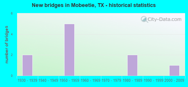
- New bridges - historical statistics
- 21930-1939
- 51950-1959
- 21980-1989
- 12000-2009

- Reconstructed bridges - Historical Statistics
- 21950-1959
- 31960-1969
- 01970-1979
- 01980-1989
- 01990-1999
- 02000-2009
- 22010-2019

- Bridge Condition - Deck
- 66.7%Good
- 33.3%Satisfactory

- Bridge Condition - Superstructure
- 33.3%Good
- 66.7%Satisfactory

- Bridge Condition - Channel
- 10.0%Very good
- 50.0%Good
- 20.0%Satisfactory
- 20.0%Fair

- Bridge Condition - Culverts
- 57.1%Good
- 42.9%Satisfactory
Find on map >> Show street view
Structure Number: 252420039702004, Location: 0.25 MI E OF FM 48 (Lat: 35.517603, Lng: -100.437653), Route carried "on" structure: State highway 152, Year Built: 1932, Year Reconstructed: 1956, Status: Open, Structure Length: 1.98m (6.50ft), Average Daily Traffic: 1,282 (year 2020), Truck Traffic: 8%, Average Future Daily Traffic: 3,030 (year 2033), Design Load: H 15, Features Intersected: ADOBE CREEK
Minimum Vertical Clearance: 30+ m (98+ ft), Kilometerpoint: 9.328, Lanes on structure: 2, Owner: State Highway Agency, Approaching Roadway Width: 12.8m (42.0ft), Skew: 5 degrees, Material/Design: Concrete, Design/Construction: Culvert, Number Of Spans In Main Unit: 6, Length of Maximum Span: 1.8m (5.9ft), Curb-To-Curb Width: 12.8m (42.0ft), Out-to-Out Width: 15.9m (52.2ft)
Condition: Channel: Satisfactory, Culverts: Good, Operating Rating: 39.9 metric tons, Method Used To Determine Operating Rating: Load Factor (LF), Inventory Rating: 23.6 metric tons, Method Used To Determine Inventory Rating: Load Factor (LF), Structural Evaluation: Equal to present minimum criteria, Deck Geometry: Better than present minimum criteria, Waterway Adequacy: Equal to present minimum criteria, Approach Roadway Alignment: Equal to present desirable criteria, Designated Inspection Frequency: Every 24 months, Inspection Date: July 2021, Deck Structure Type: Concrete Cast-file-Place, Wearing Surface/Protective System: Wearing Surface: Bituminous
Find on map >> Show street view
Structure Number: 252420039702005, Location: 0.35 MI E OF FM 48 (Lat: 35.517567, Lng: -100.436097), Route carried "on" structure: State highway 152, Year Built: 1932, Year Reconstructed: 1956, Status: Open, Structure Length: 1.16m (3.81ft), Average Daily Traffic: 1,282 (year 2020), Truck Traffic: 8%, Average Future Daily Traffic: 3,030 (year 2033), Design Load: H 15, Features Intersected: DRAW
Minimum Vertical Clearance: 30+ m (98+ ft), Kilometerpoint: 9.428, Lanes on structure: 2, Owner: State Highway Agency, Approaching Roadway Width: 12.8m (42.0ft), Skew: 3 degrees, Material/Design: Concrete, Design/Construction: Culvert, Number Of Spans In Main Unit: 5, Length of Maximum Span: 1.8m (5.9ft), Curb-To-Curb Width: 12.8m (42.0ft), Out-to-Out Width: 15.9m (52.2ft)
Condition: Channel: Satisfactory, Culverts: Satisfactory, Operating Rating: 39.9 metric tons, Method Used To Determine Operating Rating: Load Factor (LF), Inventory Rating: 23.6 metric tons, Method Used To Determine Inventory Rating: Load Factor (LF), Structural Evaluation: Equal to present minimum criteria, Deck Geometry: Better than present minimum criteria, Waterway Adequacy: Equal to present minimum criteria, Approach Roadway Alignment: Equal to present desirable criteria, Designated Inspection Frequency: Every 24 months, Inspection Date: July 2021, Deck Structure Type: Concrete Cast-file-Place, Wearing Surface/Protective System: Wearing Surface: Bituminous
Find on map >> Show street view
Structure Number: 25242003970201, Location: 2.50 MI E OF FM 48 (Lat: 35.497139, Lng: -100.410408), Route carried "on" structure: State highway 152, Year Built: 1985, Status: Open, Structure Length: 5.03m (16.50ft), Average Daily Traffic: 1,282 (year 2020), Truck Traffic: 8%, Average Future Daily Traffic: 3,030 (year 2033), Design Load: HS 20, Features Intersected: SWEETWATER CREEK
Minimum Vertical Clearance: 30+ m (98+ ft), Kilometerpoint: 12.917, Lanes on structure: 2, Owner: State Highway Agency, Approaching Roadway Width: 12.2m (40.0ft), Material/Design: Prestressed concrete, Design/Construction: Stringer/Multi-beam, Number Of Spans In Main Unit: 3, Length of Maximum Span: 16.8m (55.1ft), Curb-To-Curb Width: 12.2m (40.0ft), Out-to-Out Width: 12.9m (42.3ft)
Condition: Deck: Satisfactory, Superstructure: Satisfactory, Substructure: Good, Channel: Good, Operating Rating: 54.4 metric tons, Method Used To Determine Operating Rating: Assigned rating based on Load Factor Design (LFD) reported in metric tons, Inventory Rating: 32.7 metric tons, Method Used To Determine Inventory Rating: Assigned rating based on Load Factor Design (LFD) reported in metric tons, Structural Evaluation: Equal to present minimum criteria, Deck Geometry: Better than present minimum criteria, Waterway Adequacy: Equal to present minimum criteria, Approach Roadway Alignment: Equal to present desirable criteria, Designated Inspection Frequency: Every 24 months, Inspection Date: July 2021, Deck Structure Type: Concrete Cast-file-Place, Wearing Surface/Protective System: Wearing Surface: Bituminous
Find on map >> Show street view
Structure Number: 252420039702011, Location: 1.40 MI W OF FM 48 (Lat: 35.517558, Lng: -100.467289), Route carried "on" structure: State highway 152, Year Built: 1985, Status: Open, Structure Length: 5.03m (16.50ft), Average Daily Traffic: 1,347 (year 2020), Truck Traffic: 13%, Average Future Daily Traffic: 3,360 (year 2033), Design Load: HS 20, Features Intersected: SWEETWATER CREEK
Minimum Vertical Clearance: 30+ m (98+ ft), Kilometerpoint: 6.666, Lanes on structure: 2, Owner: State Highway Agency, Approaching Roadway Width: 12.2m (40.0ft), Material/Design: Prestressed concrete, Design/Construction: Stringer/Multi-beam, Number Of Spans In Main Unit: 3, Length of Maximum Span: 16.8m (55.1ft), Curb-To-Curb Width: 12.2m (40.0ft), Out-to-Out Width: 12.9m (42.3ft)
Condition: Deck: Good, Superstructure: Satisfactory, Substructure: Good, Channel: Good, Operating Rating: 54.4 metric tons, Method Used To Determine Operating Rating: Assigned rating based on Load Factor Design (LFD) reported in metric tons, Inventory Rating: 32.7 metric tons, Method Used To Determine Inventory Rating: Assigned rating based on Load Factor Design (LFD) reported in metric tons, Structural Evaluation: Equal to present minimum criteria, Deck Geometry: Better than present minimum criteria, Waterway Adequacy: Equal to present minimum criteria, Approach Roadway Alignment: Equal to present desirable criteria, Designated Inspection Frequency: Every 24 months, Inspection Date: July 2021, Deck Structure Type: Concrete Cast-file-Place, Wearing Surface/Protective System: Wearing Surface: Bituminous
Find on map >> Show street view
Structure Number: 252420039702012, Location: 2.05 MI E. OF FM 48 (Lat: 35.503403, Lng: -100.415369), Route carried "on" structure: State highway 152, Year Built: 2007, Status: Open, Structure Length: 4.27m (14.01ft), Average Daily Traffic: 1,282 (year 2020), Truck Traffic: 8%, Average Future Daily Traffic: 3,030 (year 2033), Design Load: HL 93, Features Intersected: ADOBE CREEK
Minimum Vertical Clearance: 30+ m (98+ ft), Kilometerpoint: 12.242, Lanes on structure: 2, Owner: State Highway Agency, Approaching Roadway Width: 13.4m (44.0ft), Material/Design: Prestressed concrete, Design/Construction: Stringer/Multi-beam, Number Of Spans In Main Unit: 2, Length of Maximum Span: 21.3m (69.9ft), Curb-To-Curb Width: 13.5m (44.3ft), Out-to-Out Width: 14.0m (45.9ft)
Condition: Deck: Good, Superstructure: Good, Substructure: Good, Channel: Good, Operating Rating: 54.4 metric tons, Method Used To Determine Operating Rating: Assigned ratings based on Load and Resistance Factor Design (LRFD) reported in metric tons, Inventory Rating: 32.7 metric tons, Method Used To Determine Inventory Rating: Assigned ratings based on Load and Resistance Factor Design (LRFD) reported in metric tons, Structural Evaluation: Better than present minimum criteria, Deck Geometry: Superior to present desirable criteria, Waterway Adequacy: Superior to present desirable criteria, Approach Roadway Alignment: Equal to present desirable criteria, Designated Inspection Frequency: Every 24 months, Inspection Date: July 2021, Deck Structure Type: Concrete Precast Panels
Find on map >> Show street view
Structure Number: 252420048901001, Location: 2.95 MI N OF SH 152 (Lat: 35.560761, Lng: -100.443292), Route carried "on" structure: State highway 48, Year Built: 1951, Year Reconstructed: 2016, Status: Open, Structure Length: 0.82m (2.69ft), Average Daily Traffic: 152 (year 2020), Truck Traffic: 10%, Average Future Daily Traffic: 270 (year 2033), Features Intersected: DRAW
Minimum Vertical Clearance: 30+ m (98+ ft), Kilometerpoint: 7.009, Lanes on structure: 2, Owner: State Highway Agency, Approaching Roadway Width: 7.0m (23.0ft), Material/Design: Concrete, Design/Construction: Culvert, Number Of Spans In Main Unit: 4, Length of Maximum Span: 1.8m (5.9ft), Curb-To-Curb Width: 7.0m (23.0ft), Out-to-Out Width: 14.5m (47.6ft)
Condition: Channel: Very good, Culverts: Satisfactory, Operating Rating: 39.9 metric tons, Method Used To Determine Operating Rating: Load Factor (LF), Inventory Rating: 23.6 metric tons, Method Used To Determine Inventory Rating: Load Factor (LF), Structural Evaluation: Equal to present minimum criteria, Deck Geometry: Meets minimum limits, Waterway Adequacy: Better than present minimum criteria, Approach Roadway Alignment: Equal to present desirable criteria, Designated Inspection Frequency: Every 24 months, Inspection Date: July 2021, Deck Structure Type: Concrete Cast-file-Place, Wearing Surface/Protective System: Wearing Surface: Bituminous
Find on map >> Show street view
Structure Number: 252420048901004, Location: 5.60 MI N OF SH 152 (Lat: 35.593281, Lng: -100.450781), Route carried "on" structure: State highway 48, Year Built: 1954, Year Reconstructed: 2016, Status: Open, Structure Length: 1.59m (5.22ft), Average Daily Traffic: 100 (year 2020), Truck Traffic: 8%, Average Future Daily Traffic: 120 (year 2033), Features Intersected: DRAW
Minimum Vertical Clearance: 30+ m (98+ ft), Kilometerpoint: 2.935, Lanes on structure: 2, Owner: State Highway Agency, Approaching Roadway Width: 8.5m (27.9ft), Material/Design: Concrete, Design/Construction: Culvert, Number Of Spans In Main Unit: 6, Length of Maximum Span: 2.4m (7.9ft)
Condition: Channel: Good, Culverts: Satisfactory, Operating Rating: 39.9 metric tons, Method Used To Determine Operating Rating: Load Factor (LF), Inventory Rating: 23.6 metric tons, Method Used To Determine Inventory Rating: Load Factor (LF), Structural Evaluation: Equal to present minimum criteria, Waterway Adequacy: Better than present minimum criteria, Approach Roadway Alignment: Equal to present desirable criteria, Designated Inspection Frequency: Every 24 months, Inspection Date: July 2021
Find on map >> Show street view
Structure Number: 252420123501002, Location: 1.80 MI E OF FM 48 (Lat: 35.544797, Lng: -100.412464), Route carried "on" structure: State highway 1046, Year Built: 1953, Year Reconstructed: 1971, Status: Open, Structure Length: 1.19m (3.90ft), Average Daily Traffic: 313 (year 2020), Truck Traffic: 11%, Average Future Daily Traffic: 840 (year 2033), Features Intersected: RUSSELL CREEK
Minimum Vertical Clearance: 30+ m (98+ ft), Kilometerpoint: 2.873, Lanes on structure: 2, Owner: State Highway Agency, Approaching Roadway Width: 7.3m (24.0ft), Material/Design: Concrete, Design/Construction: Culvert, Number Of Spans In Main Unit: 4, Length of Maximum Span: 2.7m (8.9ft)
Condition: Channel: Good, Culverts: Good, Operating Rating: 39.9 metric tons, Method Used To Determine Operating Rating: Load Factor (LF), Inventory Rating: 23.6 metric tons, Method Used To Determine Inventory Rating: Load Factor (LF), Structural Evaluation: Equal to present minimum criteria, Waterway Adequacy: Equal to present minimum criteria, Approach Roadway Alignment: Equal to present desirable criteria, Designated Inspection Frequency: Every 24 months, Inspection Date: July 2021
Find on map >> Show street view
Structure Number: 252420123501003, Location: 2.40 MI E OF FM 48 (Lat: 35.548150, Lng: -100.402208), Route carried "on" structure: State highway 1046, Year Built: 1953, Year Reconstructed: 1971, Status: Open, Structure Length: 1.19m (3.90ft), Average Daily Traffic: 313 (year 2020), Truck Traffic: 11%, Average Future Daily Traffic: 840 (year 2033), Features Intersected: CASSINO CREEK
Minimum Vertical Clearance: 30+ m (98+ ft), Kilometerpoint: 3.859, Lanes on structure: 2, Owner: State Highway Agency, Approaching Roadway Width: 7.3m (24.0ft), Material/Design: Concrete, Design/Construction: Culvert, Number Of Spans In Main Unit: 4, Length of Maximum Span: 2.7m (8.9ft)
Condition: Channel: Fair, Culverts: Good, Operating Rating: 39.9 metric tons, Method Used To Determine Operating Rating: Load Factor (LF), Inventory Rating: 23.6 metric tons, Method Used To Determine Inventory Rating: Load Factor (LF), Structural Evaluation: Equal to present minimum criteria, Waterway Adequacy: Equal to present minimum criteria, Approach Roadway Alignment: Equal to present desirable criteria, Designated Inspection Frequency: Every 24 months, Inspection Date: July 2021
Find on map >> Show street view
Structure Number: 252420123501004, Location: 3.25 MI E OF FM 48 (Lat: 35.551836, Lng: -100.390939), Route carried "on" structure: State highway 1046, Year Built: 1953, Year Reconstructed: 1971, Status: Open, Structure Length: 0.94m (3.08ft), Average Daily Traffic: 313 (year 2020), Truck Traffic: 11%, Average Future Daily Traffic: 840 (year 2033), Features Intersected: DRAW
Minimum Vertical Clearance: 30+ m (98+ ft), Kilometerpoint: 5.123, Lanes on structure: 2, Owner: State Highway Agency, Approaching Roadway Width: 7.3m (24.0ft), Material/Design: Concrete, Design/Construction: Culvert, Number Of Spans In Main Unit: 4, Length of Maximum Span: 2.1m (6.9ft)
Condition: Channel: Fair, Culverts: Good, Operating Rating: 39.9 metric tons, Method Used To Determine Operating Rating: Load Factor (LF), Inventory Rating: 23.6 metric tons, Method Used To Determine Inventory Rating: Load Factor (LF), Structural Evaluation: Equal to present minimum criteria, Waterway Adequacy: Equal to present minimum criteria, Approach Roadway Alignment: Equal to present desirable criteria, Designated Inspection Frequency: Every 24 months, Inspection Date: July 2021