Bridge Statistics for Mojave, California (CA)
Condition, Traffic, Stress, Structural Evaluation, Project Costs
- National Bridge Inventory (NBI) Statistics
- 32Number of bridges
- 581ft / 177mTotal length
- 499,000Total average daily traffic
- 127,904Total average daily truck traffic
- National Bridge Inventory (NBI) Registered Bridges for Mojave
- No street view available for this location
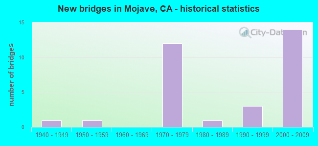
- New bridges - historical statistics
- 11940-1949
- 11950-1959
- 121970-1979
- 11980-1989
- 31990-1999
- 142000-2009


- Bridge Condition - Deck
- 55.0%Good
- 45.0%Fair

- Bridge Condition - Superstructure
- 90.0%Good
- 10.0%Fair

- Bridge Condition - Substructure
- 75.0%Good
- 5.0%Satisfactory
- 20.0%Fair

- Bridge Condition - Channel
- 11.8%Excellent
- 76.5%Very good
- 5.9%Good
- 5.9%Satisfactory
Find on map >> Show street view
Structure Number: 50 0139, Location: 09-KER-058-103.44 (Lat: 35.104417, Lng: -118.271339), Route carried "on" structure: State highway 58, Year Built: 1957, Year Reconstructed: 1991, Status: Open, Structure Length: 1.86m (6.10ft), Average Daily Traffic: 40,000 (year 2011), Truck Traffic: 33%, Average Future Daily Traffic: 60,170 (year 2040), Design Load: HS 20, Features Intersected: LA ROSE CREEK
Minimum Vertical Clearance: 30+ m (98+ ft), Kilometerpoint: 103.440, Lanes on structure: 4, Base Highway Network: Yes (, Subroute: 3), Owner: State Highway Agency, Approaching Roadway Width: 23.8m (78.1ft), Skew: 30 degrees, Material/Design: Concrete continuous, Design/Construction: Slab, Number Of Spans In Main Unit: 3, Length of Maximum Span: 6.1m (20.0ft), Curb-To-Curb Width: 23.2m (76.1ft), Out-to-Out Width: 24.8m (81.4ft)
Condition: Deck: Good, Superstructure: Good, Substructure: Good, Channel: Good, Operating Rating: 37.3 metric tons, Method Used To Determine Operating Rating: Load and Resistance Factor Rating (LRFR) rating reported by rating factor(RF) method using HL-93 loadings, Inventory Rating: 28.8 metric tons, Method Used To Determine Inventory Rating: Load and Resistance Factor Rating (LRFR) rating reported by rating factor(RF) method using HL-93 loadings, Structural Evaluation: Better than present minimum criteria, Deck Geometry: Superior to present desirable criteria, Waterway Adequacy: Better than present minimum criteria, Approach Roadway Alignment: Equal to present desirable criteria, Designated Inspection Frequency: Every 24 months, Inspection Date: May 2021, Deck Structure Type: Concrete Cast-file-Place, Wearing Surface/Protective System: Wearing Surface: Integral Concrete
Find on map >> Show street view
Structure Number: 50 0201L, Location: 09-KER-058-R107.61 (Lat: 35.116789, Lng: -118.201567), Route carried "on" structure: State highway 58, Year Built: 1946, Year Reconstructed: 1991, Status: Open, Structure Length: 8.35m (27.40ft), Average Daily Traffic: 20,000 (year 2011), Truck Traffic: 33%, Average Future Daily Traffic: 30,340 (year 2040), Features Intersected: CACHE CREEK
Minimum Vertical Clearance: 30+ m (98+ ft), Kilometerpoint: 107.610, Lanes on structure: 2, Base Highway Network: Yes (, Subroute: 1), Owner: State Highway Agency, Approaching Roadway Width: 11.3m (37.1ft), Material/Design: Steel continuous, Design/Construction: Stringer/Multi-beam, Number Of Spans In Main Unit: 6, Length of Maximum Span: 14.0m (45.9ft), Curb-To-Curb Width: 11.3m (37.1ft), Out-to-Out Width: 12.4m (40.7ft)
Condition: Deck: Good, Superstructure: Good, Substructure: Fair, Channel: Very good, Operating Rating: 55.1 metric tons, Method Used To Determine Operating Rating: Load Factor (LF), Inventory Rating: 33.0 metric tons, Method Used To Determine Inventory Rating: Load Factor (LF), Structural Evaluation: Somewhat better than minimum adequacy, Deck Geometry: Equal to present minimum criteria, Waterway Adequacy: Better than present minimum criteria, Approach Roadway Alignment: Equal to present desirable criteria, Designated Inspection Frequency: Every 24 months, Critical Feature Inspection Frequency: Every 24 months, Other Special Inspection Frequency: Every 48 months, Inspection Date: May 2021, Critical Feature Inspection Date: March 2021, Other Special Inspection Date: March 2021, Deck Structure Type: Concrete Cast-file-Place, Wearing Surface/Protective System: Wearing Surface: Integral Concrete
Find on map >> Show street view
Structure Number: 50 0201R, Location: 09-KER-058-R107.60 (Lat: 35.116686, Lng: -118.201956), Route carried "on" structure: State highway 58, Year Built: 1983, Status: Open, Structure Length: 8.23m (27.00ft), Average Daily Traffic: 20,000 (year 2011), Truck Traffic: 33%, Average Future Daily Traffic: 30,340 (year 2040), Design Load: HS 20+Mod, Features Intersected: CACHE CREEK
Minimum Vertical Clearance: 30+ m (98+ ft), Kilometerpoint: 107.600, Lanes on structure: 2, Base Highway Network: Yes (, Subroute: 1), Owner: State Highway Agency, Approaching Roadway Width: 11.3m (37.1ft), Skew: 6 degrees, Material/Design: Concrete continuous, Design/Construction: Box Beam or Girders - Multiple, Number Of Spans In Main Unit: 4, Length of Maximum Span: 22.3m (73.2ft), Curb-To-Curb Width: 11.3m (37.1ft), Out-to-Out Width: 12.3m (40.4ft)
Condition: Deck: Good, Superstructure: Good, Substructure: Fair, Channel: Very good, Operating Rating: 54.1 metric tons, Method Used To Determine Operating Rating: Assigned rating based on Load Factor Design (LFD) reported in metric tons, Inventory Rating: 32.4 metric tons, Method Used To Determine Inventory Rating: Assigned rating based on Load Factor Design (LFD) reported in metric tons, Structural Evaluation: Somewhat better than minimum adequacy, Deck Geometry: Equal to present minimum criteria, Waterway Adequacy: Equal to present desirable criteria, Approach Roadway Alignment: Equal to present desirable criteria, Designated Inspection Frequency: Every 24 months, Inspection Date: May 2021, Deck Structure Type: Concrete Cast-file-Place, Wearing Surface/Protective System: Wearing Surface: Integral Concrete
Find on map >> Show street view
Structure Number: 50 0347, Location: 09-KER-058-R101.56 (Lat: 35.099700, Lng: -118.292914), Route carried "on" structure: County highway , Year Built: 1970, Status: Open, Structure Length: 6.55m (21.49ft), Average Daily Traffic: 600 (year 2011), Truck Traffic: 20%, Average Future Daily Traffic: 1,216 (year 2040), Design Load: HS 20, Features Intersected: STATE ROUTE 58, Facility Carried by Structure: CAMERON ROAD
Minimum Vertical Clearance: 30+ m (98+ ft), Kilometerpoint: 0.000, Lanes on structure: 2, Lanes under structure: 4, Owner: State Highway Agency, Approaching Roadway Width: 12.2m (40.0ft), Skew: 3 degrees, Material/Design: Concrete continuous, Design/Construction: Box Beam or Girders - Multiple, Number Of Spans In Main Unit: 2, Length of Maximum Span: 35.4m (116.1ft), Curb-To-Curb Width: 12.2m (40.0ft), Out-to-Out Width: 12.8m (42.0ft)
Condition: Deck: Good, Superstructure: Good, Substructure: Good, Operating Rating: 56.4 metric tons, Method Used To Determine Operating Rating: Load and Resistance Factor Rating (LRFR) rating reported by rating factor(RF) method using HL-93 loadings, Inventory Rating: 43.4 metric tons, Method Used To Determine Inventory Rating: Load and Resistance Factor Rating (LRFR) rating reported by rating factor(RF) method using HL-93 loadings, Structural Evaluation: Better than present minimum criteria, Deck Geometry: Equal to present desirable criteria, Underclear: Equal to present minimum criteria, Approach Roadway Alignment: Equal to present desirable criteria, Designated Inspection Frequency: Every 24 months, Inspection Date: May 2021, Deck Structure Type: Concrete Cast-file-Place, Wearing Surface/Protective System: Wearing Surface: Integral Concrete
Find on map >> Show street view
Structure Number: 50 0386, Location: 09-KER-014-R9.14 (Lat: 34.951836, Lng: -118.161553), Route carried "on" structure: County highway , Year Built: 1972, Status: Open, Structure Length: 7.53m (24.70ft), Average Daily Traffic: 200 (year 2014), Truck Traffic: 9%, Average Future Daily Traffic: 358 (year 2041), Design Load: HS 20, Features Intersected: STATE ROUTE 14, Facility Carried by Structure: BACKUS ROAD
Minimum Vertical Clearance: 30+ m (98+ ft), Kilometerpoint: 0.000, Lanes on structure: 2, Lanes under structure: 4, Owner: State Highway Agency, Approaching Roadway Width: 12.2m (40.0ft), Material/Design: Prestressed concrete continuous, Design/Construction: Box Beam or Girders - Multiple, Number Of Spans In Main Unit: 2, Length of Maximum Span: 38.4m (126.0ft), Curb-To-Curb Width: 12.2m (40.0ft), Out-to-Out Width: 12.8m (42.0ft)
Condition: Deck: Good, Superstructure: Good, Substructure: Good, Operating Rating: 59.9 metric tons, Method Used To Determine Operating Rating: Load and Resistance Factor Rating (LRFR) rating reported by rating factor(RF) method using HL-93 loadings, Inventory Rating: 40.2 metric tons, Method Used To Determine Inventory Rating: Load and Resistance Factor Rating (LRFR) rating reported by rating factor(RF) method using HL-93 loadings, Structural Evaluation: Better than present minimum criteria, Deck Geometry: Superior to present desirable criteria, Underclear: Better than present minimum criteria, Approach Roadway Alignment: Equal to present desirable criteria, Designated Inspection Frequency: Every 24 months, Inspection Date: April 2021, Deck Structure Type: Concrete Cast-file-Place
Find on map >> Show street view
Structure Number: 50 0387, Location: 09-KER-014-R12.15 (Lat: 34.995378, Lng: -118.160075), Route carried "on" structure: County highway , Year Built: 1972, Status: Open, Structure Length: 7.53m (24.70ft), Average Daily Traffic: 20,200 (year 2017), Truck Traffic: 9%, Average Future Daily Traffic: 52,360 (year 2041), Design Load: HS 20, Features Intersected: STATE ROUTE 14, Facility Carried by Structure: SILVER QUEEN ROAD
Minimum Vertical Clearance: 30+ m (98+ ft), Kilometerpoint: 0.000, Lanes on structure: 2, Lanes under structure: 4, Owner: State Highway Agency, Approaching Roadway Width: 12.2m (40.0ft), Material/Design: Prestressed concrete continuous, Design/Construction: Box Beam or Girders - Multiple, Number Of Spans In Main Unit: 2, Length of Maximum Span: 38.4m (126.0ft), Curb-To-Curb Width: 12.2m (40.0ft), Out-to-Out Width: 12.8m (42.0ft)
Condition: Deck: Fair, Superstructure: Good, Substructure: Good, Operating Rating: 59.9 metric tons, Method Used To Determine Operating Rating: Load and Resistance Factor Rating (LRFR) rating reported by rating factor(RF) method using HL-93 loadings, Inventory Rating: 40.5 metric tons, Method Used To Determine Inventory Rating: Load and Resistance Factor Rating (LRFR) rating reported by rating factor(RF) method using HL-93 loadings, Structural Evaluation: Better than present minimum criteria, Deck Geometry: Somewhat better than minimum adequacy, Underclear: Equal to present minimum criteria, Approach Roadway Alignment: Equal to present desirable criteria, Designated Inspection Frequency: Every 24 months, Inspection Date: April 2021, Deck Structure Type: Concrete Cast-file-Place
Find on map >> Show street view
Structure Number: 50 0402L, Location: 09-KER-014-R15.33 (Lat: 35.037853, Lng: -118.169756), Route carried "on" structure: State highway 14, Year Built: 1990, Status: Open, Structure Length: 19.14m (62.80ft), Average Daily Traffic: 8,975 (year 2014), Truck Traffic: 9%, Average Future Daily Traffic: 31,344 (year 2041), Design Load: HS 20+Mod, Features Intersected: UP RR & BNSF RY
Minimum Vertical Clearance: 30+ m (98+ ft), Kilometerpoint: 15.330, Lanes on structure: 2, Base Highway Network: Yes (, Subroute: 1), Owner: State Highway Agency, Approaching Roadway Width: 11.3m (37.1ft), Material/Design: Prestressed concrete continuous, Design/Construction: Box Beam or Girders - Multiple, Number Of Spans In Main Unit: 4, Length of Maximum Span: 56.4m (185.0ft), Curb-To-Curb Width: 11.3m (37.1ft), Out-to-Out Width: 12.3m (40.4ft)
Condition: Deck: Fair, Superstructure: Good, Substructure: Good, Operating Rating: 54.1 metric tons, Method Used To Determine Operating Rating: Assigned rating based on Load Factor Design (LFD) reported in metric tons, Inventory Rating: 32.4 metric tons, Method Used To Determine Inventory Rating: Assigned rating based on Load Factor Design (LFD) reported in metric tons, Structural Evaluation: Better than present minimum criteria, Deck Geometry: Equal to present minimum criteria, Underclear: Meets minimum limits, Approach Roadway Alignment: Equal to present desirable criteria, Designated Inspection Frequency: Every 24 months, Inspection Date: April 2021, Deck Structure Type: Concrete Cast-file-Place
Find on map >> Show street view
Structure Number: 50 0402R, Location: 09-KER-014-R15.30 (Lat: 35.037492, Lng: -118.169597), Route carried "on" structure: State highway 14, Year Built: 1972, Status: Open, Structure Length: 19.02m (62.40ft), Average Daily Traffic: 8,975 (year 2017), Truck Traffic: 9%, Average Future Daily Traffic: 31,344 (year 2041), Design Load: HS 20, Features Intersected: UP RR & BNSF RY
Minimum Vertical Clearance: 30+ m (98+ ft), Kilometerpoint: 15.300, Lanes on structure: 2, Base Highway Network: Yes (, Subroute: 1), Owner: State Highway Agency, Approaching Roadway Width: 12.2m (40.0ft), Material/Design: Prestressed concrete continuous, Design/Construction: Box Beam or Girders - Multiple, Number Of Spans In Main Unit: 4, Length of Maximum Span: 59.1m (193.9ft), Curb-To-Curb Width: 12.2m (40.0ft), Out-to-Out Width: 12.8m (42.0ft)
Condition: Deck: Good, Superstructure: Good, Substructure: Good, Operating Rating: 56.1 metric tons, Method Used To Determine Operating Rating: Load and Resistance Factor Rating (LRFR) rating reported by rating factor(RF) method using HL-93 loadings, Inventory Rating: 34.0 metric tons, Method Used To Determine Inventory Rating: Load and Resistance Factor Rating (LRFR) rating reported by rating factor(RF) method using HL-93 loadings, Structural Evaluation: Better than present minimum criteria, Deck Geometry: Better than present minimum criteria, Underclear: Meets minimum limits, Approach Roadway Alignment: Equal to present desirable criteria, Designated Inspection Frequency: Every 24 months, Inspection Date: April 2021, Deck Structure Type: Concrete Cast-file-Place, Wearing Surface/Protective System: Wearing Surface: Integral Concrete
Find on map >> Show street view
Structure Number: 50 0453, Location: 09-KER-014-R9.30 (Lat: 34.955094, Lng: -118.160500), Route carried "on" structure: State highway 14, Year Built: 1972, Status: Open, Structure Length: 0.90m (2.95ft), Average Daily Traffic: 17,600 (year 2014), Truck Traffic: 14%, Average Future Daily Traffic: 53,276 (year 2041), Features Intersected: BACKUS ROAD DRAIN NO. 1
Minimum Vertical Clearance: 30+ m (98+ ft), Kilometerpoint: 9.300, Lanes on structure: 6, Base Highway Network: Yes (, Subroute: 1), Owner: State Highway Agency, Approaching Roadway Width: 11.9m (39.0ft), Skew: 13 degrees, Material/Design: Concrete continuous, Design/Construction: Culvert, Number Of Spans In Main Unit: 6, Length of Maximum Span: 1.5m (4.9ft)
Condition: Channel: Very good, Culverts: Good, Operating Rating: 54.1 metric tons, Method Used To Determine Operating Rating: Field evaluation and documented engineering judgment, Inventory Rating: 32.4 metric tons, Method Used To Determine Inventory Rating: Field evaluation and documented engineering judgment, Structural Evaluation: Better than present minimum criteria, Waterway Adequacy: Equal to present desirable criteria, Approach Roadway Alignment: Equal to present desirable criteria, Designated Inspection Frequency: Every 24 months, Inspection Date: April 2021
Find on map >> Show street view
Structure Number: 50 0453Y, Location: 09-KER-014-R9.30 (Lat: 34.954922, Lng: -118.159778), Route carried "on" structure: ServiceState highway 14, Year Built: 1972, Status: Open, Structure Length: 0.90m (2.95ft), Average Daily Traffic: 50 (year 2014), Truck Traffic: 2%, Average Future Daily Traffic: 104 (year 2041), Features Intersected: BACKUS ROAD DRAIN NO. 1, Facility Carried by Structure: EAST FRONTAGE ROAD
Minimum Vertical Clearance: 30+ m (98+ ft), Kilometerpoint: 9.300, Lanes on structure: 2, Owner: State Highway Agency, Approaching Roadway Width: 7.3m (24.0ft), Skew: 3 degrees, Material/Design: Concrete, Design/Construction: Culvert, Number Of Spans In Main Unit: 6, Length of Maximum Span: 1.5m (4.9ft)
Condition: Channel: Very good, Culverts: Good, Operating Rating: 54.1 metric tons, Method Used To Determine Operating Rating: Field evaluation and documented engineering judgment, Inventory Rating: 32.4 metric tons, Method Used To Determine Inventory Rating: Field evaluation and documented engineering judgment, Structural Evaluation: Better than present minimum criteria, Waterway Adequacy: Equal to present desirable criteria, Approach Roadway Alignment: Equal to present desirable criteria, Designated Inspection Frequency: Every 24 months, Inspection Date: April 2021
Find on map >> Show street view
Structure Number: 50 0454, Location: 09-KER-014-R9.80 (Lat: 34.962539, Lng: -118.160075), Route carried "on" structure: State highway 14, Year Built: 1972, Status: Open, Structure Length: 0.90m (2.95ft), Average Daily Traffic: 17,600 (year 2014), Truck Traffic: 14%, Average Future Daily Traffic: 53,276 (year 2041), Features Intersected: BACKUS ROAD DRAIN NO. 2
Minimum Vertical Clearance: 30+ m (98+ ft), Kilometerpoint: 9.800, Lanes on structure: 4, Base Highway Network: Yes (, Subroute: 1), Owner: State Highway Agency, Approaching Roadway Width: 11.9m (39.0ft), Skew: 10 degrees, Material/Design: Concrete continuous, Design/Construction: Culvert, Number Of Spans In Main Unit: 6, Length of Maximum Span: 1.5m (4.9ft)
Condition: Channel: Very good, Culverts: Good, Operating Rating: 54.1 metric tons, Method Used To Determine Operating Rating: Field evaluation and documented engineering judgment, Inventory Rating: 32.4 metric tons, Method Used To Determine Inventory Rating: Field evaluation and documented engineering judgment, Structural Evaluation: Better than present minimum criteria, Waterway Adequacy: Equal to present desirable criteria, Approach Roadway Alignment: Equal to present desirable criteria, Designated Inspection Frequency: Every 24 months, Inspection Date: April 2021
Find on map >> Show street view
Structure Number: 50 0455, Location: 09-KER-014-R11.30 (Lat: 34.984206, Lng: -118.158839), Route carried "on" structure: State highway 14, Year Built: 1972, Status: Open, Structure Length: 0.70m (2.30ft), Average Daily Traffic: 20,200 (year 2017), Truck Traffic: 14%, Average Future Daily Traffic: 62,617 (year 2041), Features Intersected: SILVER QUEEN RD DRAIN
Minimum Vertical Clearance: 30+ m (98+ ft), Kilometerpoint: 11.300, Lanes on structure: 4, Base Highway Network: Yes (, Subroute: 1), Owner: State Highway Agency, Approaching Roadway Width: 11.9m (39.0ft), Skew: 13 degrees, Material/Design: Concrete continuous, Design/Construction: Culvert, Number Of Spans In Main Unit: 3, Length of Maximum Span: 2.2m (7.2ft)
Condition: Channel: Very good, Culverts: Good, Operating Rating: 54.1 metric tons, Method Used To Determine Operating Rating: Field evaluation and documented engineering judgment, Inventory Rating: 32.4 metric tons, Method Used To Determine Inventory Rating: Field evaluation and documented engineering judgment, Structural Evaluation: Better than present minimum criteria, Waterway Adequacy: Equal to present desirable criteria, Approach Roadway Alignment: Equal to present desirable criteria, Designated Inspection Frequency: Every 24 months, Inspection Date: April 2021
Find on map >> Show street view
Structure Number: 50 0492, Location: 09-KER-058-M116.37 (Lat: 35.038261, Lng: -118.106653), Route carried "on" structure: Business County highway , Year Built: 2003, Status: Open, Structure Length: 8.15m (26.74ft), Average Daily Traffic: 1,300 (year 2011), Truck Traffic: 10%, Average Future Daily Traffic: 1,890 (year 2040), Design Load: HS 20+Mod, Features Intersected: STATE ROUTE 58, Facility Carried by Structure: BUSINESS 58 EAST
Minimum Vertical Clearance: 30+ m (98+ ft), Kilometerpoint: 0.000, Lanes on structure: 4, Lanes under structure: 4, Base Highway Network: Yes, Owner: State Highway Agency, Approaching Roadway Width: 27.0m (88.6ft), Material/Design: Prestressed concrete continuous, Design/Construction: Box Beam or Girders - Multiple, Number Of Spans In Main Unit: 2, Length of Maximum Span: 41.0m (134.5ft), Curb-To-Curb Width: 27.0m (88.6ft), Out-to-Out Width: 28.1m (92.2ft)
Condition: Deck: Good, Superstructure: Good, Substructure: Satisfactory, Operating Rating: 54.1 metric tons, Method Used To Determine Operating Rating: Assigned rating based on Load Factor Design (LFD) reported in metric tons, Inventory Rating: 32.4 metric tons, Method Used To Determine Inventory Rating: Assigned rating based on Load Factor Design (LFD) reported in metric tons, Structural Evaluation: Equal to present minimum criteria, Deck Geometry: Superior to present desirable criteria, Underclear: Better than present minimum criteria, Approach Roadway Alignment: Equal to present desirable criteria, Designated Inspection Frequency: Every 24 months, Inspection Date: June 2021, Deck Structure Type: Concrete Cast-file-Place
Find on map >> Show street view
Structure Number: 50 0494L, Location: 09-KER-058-M108.47 (Lat: 35.115339, Lng: -118.186361), Route carried "on" structure: State highway 58, Year Built: 2003, Status: Open, Structure Length: 8.14m (26.71ft), Average Daily Traffic: 19,900 (year 2011), Truck Traffic: 35%, Average Future Daily Traffic: 28,755 (year 2040), Design Load: HS 20+Mod, Features Intersected: LA DWP WEST AQUEDUCT
Minimum Vertical Clearance: 30+ m (98+ ft), Kilometerpoint: 108.470, Lanes on structure: 3, Base Highway Network: Yes (, Subroute: 3), Owner: State Highway Agency, Approaching Roadway Width: 16.8m (55.1ft), Material/Design: Prestressed concrete continuous, Design/Construction: Box Beam or Girders - Multiple, Number Of Spans In Main Unit: 3, Length of Maximum Span: 32.3m (106.0ft), Curb-To-Curb Width: 16.8m (55.1ft), Out-to-Out Width: 17.9m (58.7ft)
Condition: Deck: Fair, Superstructure: Good, Substructure: Good, Channel: Very good, Operating Rating: 54.1 metric tons, Method Used To Determine Operating Rating: Assigned rating based on Load Factor Design (LFD) reported in metric tons, Inventory Rating: 32.4 metric tons, Method Used To Determine Inventory Rating: Assigned rating based on Load Factor Design (LFD) reported in metric tons, Structural Evaluation: Better than present minimum criteria, Deck Geometry: Superior to present desirable criteria, Waterway Adequacy: Equal to present desirable criteria, Approach Roadway Alignment: Equal to present desirable criteria, Designated Inspection Frequency: Every 24 months, Inspection Date: June 2021, Deck Structure Type: Concrete Cast-file-Place
Find on map >> Show street view
Structure Number: 50 0494R, Location: 09-KER-058-M108.47 (Lat: 35.115150, Lng: -118.186378), Route carried "on" structure: State highway 58, Year Built: 2003, Status: Open, Structure Length: 8.15m (26.74ft), Average Daily Traffic: 14,050 (year 2011), Truck Traffic: 35%, Average Future Daily Traffic: 20,302 (year 2040), Design Load: HS 20+Mod, Features Intersected: LA DWP WEST AQUEDUCT
Minimum Vertical Clearance: 30+ m (98+ ft), Kilometerpoint: 108.470, Lanes on structure: 2, Base Highway Network: Yes (, Subroute: 3), Owner: State Highway Agency, Approaching Roadway Width: 11.7m (38.4ft), Material/Design: Prestressed concrete continuous, Design/Construction: Box Beam or Girders - Multiple, Number Of Spans In Main Unit: 3, Length of Maximum Span: 32.3m (106.0ft), Curb-To-Curb Width: 11.7m (38.4ft), Out-to-Out Width: 12.8m (42.0ft)
Condition: Deck: Fair, Superstructure: Good, Substructure: Good, Channel: Very good, Operating Rating: 54.1 metric tons, Method Used To Determine Operating Rating: Assigned rating based on Load Factor Design (LFD) reported in metric tons, Inventory Rating: 32.4 metric tons, Method Used To Determine Inventory Rating: Assigned rating based on Load Factor Design (LFD) reported in metric tons, Structural Evaluation: Better than present minimum criteria, Deck Geometry: Better than present minimum criteria, Waterway Adequacy: Equal to present desirable criteria, Approach Roadway Alignment: Equal to present desirable criteria, Designated Inspection Frequency: Every 24 months, Inspection Date: June 2021, Deck Structure Type: Concrete Cast-file-Place
Find on map >> Show street view
Structure Number: 50 0495R, Location: 09-KER-058-M111.78 (Lat: 35.093894, Lng: -118.134294), Route carried "on" structure: State highway 58, Year Built: 2003, Status: Open, Structure Length: 7.70m (25.26ft), Average Daily Traffic: 17,000 (year 2011), Truck Traffic: 35%, Average Future Daily Traffic: 24,565 (year 2040), Design Load: HS 20+Mod, Features Intersected: UNION PACIFIC RR (UP RR)
Minimum Vertical Clearance: 30+ m (98+ ft), Kilometerpoint: 111.780, Lanes on structure: 2, Base Highway Network: Yes (, Subroute: 3), Owner: State Highway Agency, Approaching Roadway Width: 11.7m (38.4ft), Skew: 1 degrees, Material/Design: Prestressed concrete continuous, Design/Construction: Box Beam or Girders - Multiple, Number Of Spans In Main Unit: 3, Length of Maximum Span: 30.8m (101.0ft), Curb-To-Curb Width: 11.7m (38.4ft), Out-to-Out Width: 12.8m (42.0ft)
Condition: Deck: Good, Superstructure: Good, Substructure: Good, Operating Rating: 54.1 metric tons, Method Used To Determine Operating Rating: Assigned rating based on Load Factor Design (LFD) reported in metric tons, Inventory Rating: 32.4 metric tons, Method Used To Determine Inventory Rating: Assigned rating based on Load Factor Design (LFD) reported in metric tons, Structural Evaluation: Better than present minimum criteria, Deck Geometry: Better than present minimum criteria, Underclear: Superior to present desirable criteria, Approach Roadway Alignment: Equal to present desirable criteria, Designated Inspection Frequency: Every 24 months, Inspection Date: June 2021, Deck Structure Type: Concrete Cast-file-Place
Find on map >> Show street view
Structure Number: 50 0496, Location: 09-KER-058-M108.90 (Lat: 35.114122, Lng: -118.179042), Route carried "on" structure: County highway , Year Built: 2003, Status: Open, Structure Length: 7.57m (24.84ft), Average Daily Traffic: 4,000 (year 2011), Truck Traffic: 35%, Average Future Daily Traffic: 5,780 (year 2040), Design Load: HS 20+Mod, Features Intersected: STATE ROUTE 58, Facility Carried by Structure: BUSINESS ROUTE 58
Minimum Vertical Clearance: 30+ m (98+ ft), Kilometerpoint: 0.000, Lanes on structure: 3, Lanes under structure: 4, Base Highway Network: Yes, Owner: State Highway Agency, Approaching Roadway Width: 27.0m (88.6ft), Material/Design: Prestressed concrete continuous, Design/Construction: Box Beam or Girders - Multiple, Number Of Spans In Main Unit: 2, Length of Maximum Span: 38.0m (124.7ft), Curb-To-Curb Width: 27.0m (88.6ft), Out-to-Out Width: 28.1m (92.2ft)
Condition: Deck: Good, Superstructure: Good, Substructure: Good, Operating Rating: 49.9 metric tons, Method Used To Determine Operating Rating: Load and Resistance Factor Rating (LRFR) rating reported by rating factor(RF) method using HL-93 loadings, Inventory Rating: 35.0 metric tons, Method Used To Determine Inventory Rating: Load and Resistance Factor Rating (LRFR) rating reported by rating factor(RF) method using HL-93 loadings, Structural Evaluation: Better than present minimum criteria, Deck Geometry: Superior to present desirable criteria, Underclear: Better than present minimum criteria, Approach Roadway Alignment: Equal to present desirable criteria, Designated Inspection Frequency: Every 24 months, Inspection Date: June 2021, Deck Structure Type: Concrete Cast-file-Place
Find on map >> Show street view
Structure Number: 50 0497K, Location: 09-KER-058-M108.60 (Lat: 35.115036, Lng: -118.183964), Route carried "on" structure: Ramp State highway 58, Year Built: 2003, Status: Open, Structure Length: 7.90m (25.92ft), Average Daily Traffic: 3,100 (year 2011), Truck Traffic: 35%, Average Future Daily Traffic: 4,479 (year 2040), Design Load: HS 20+Mod, Features Intersected: LA DWP EAST AQUEDUCT
Minimum Vertical Clearance: 30+ m (98+ ft), Kilometerpoint: 108.600, Lanes on structure: 1, Base Highway Network: Yes (, Subroute: 3), Owner: State Highway Agency, Approaching Roadway Width: 7.2m (23.6ft), Skew: 9 degrees, Material/Design: Prestressed concrete continuous, Design/Construction: Box Beam or Girders - Multiple, Number Of Spans In Main Unit: 3, Length of Maximum Span: 32.3m (106.0ft), Curb-To-Curb Width: 7.2m (23.6ft), Out-to-Out Width: 8.3m (27.2ft)
Condition: Deck: Fair, Superstructure: Good, Substructure: Good, Channel: Very good, Operating Rating: 54.1 metric tons, Method Used To Determine Operating Rating: Assigned rating based on Load Factor Design (LFD) reported in metric tons, Inventory Rating: 32.4 metric tons, Method Used To Determine Inventory Rating: Assigned rating based on Load Factor Design (LFD) reported in metric tons, Structural Evaluation: Better than present minimum criteria, Deck Geometry: Equal to present minimum criteria, Waterway Adequacy: Equal to present desirable criteria, Approach Roadway Alignment: Equal to present desirable criteria, Designated Inspection Frequency: Every 24 months, Inspection Date: June 2021, Deck Structure Type: Concrete Cast-file-Place
Find on map >> Show street view
Structure Number: 50 0497L, Location: 09-KER-058-M108.60 (Lat: 35.114911, Lng: -118.183983), Route carried "on" structure: State highway 58, Year Built: 2003, Status: Open, Structure Length: 7.96m (26.12ft), Average Daily Traffic: 14,000 (year 2011), Truck Traffic: 35%, Average Future Daily Traffic: 20,230 (year 2040), Design Load: HS 20+Mod, Features Intersected: LA DWP EAST AQUEDUCT
Minimum Vertical Clearance: 30+ m (98+ ft), Kilometerpoint: 108.600, Lanes on structure: 2, Base Highway Network: Yes (, Subroute: 3), Owner: State Highway Agency, Approaching Roadway Width: 11.7m (38.4ft), Material/Design: Prestressed concrete continuous, Design/Construction: Box Beam or Girders - Multiple, Number Of Spans In Main Unit: 3, Length of Maximum Span: 32.3m (106.0ft), Curb-To-Curb Width: 11.7m (38.4ft), Out-to-Out Width: 12.8m (42.0ft)
Condition: Deck: Good, Superstructure: Good, Substructure: Good, Channel: Very good, Operating Rating: 54.1 metric tons, Method Used To Determine Operating Rating: Assigned rating based on Load Factor Design (LFD) reported in metric tons, Inventory Rating: 32.4 metric tons, Method Used To Determine Inventory Rating: Assigned rating based on Load Factor Design (LFD) reported in metric tons, Structural Evaluation: Better than present minimum criteria, Deck Geometry: Better than present minimum criteria, Waterway Adequacy: Equal to present desirable criteria, Approach Roadway Alignment: Equal to present desirable criteria, Designated Inspection Frequency: Every 24 months, Inspection Date: June 2021, Deck Structure Type: Concrete Cast-file-Place
Find on map >> Show street view
Structure Number: 50 0497R, Location: 09-KER-058-M108.60 (Lat: 35.114694, Lng: -118.184006), Route carried "on" structure: State highway 58, Year Built: 2003, Status: Open, Structure Length: 7.97m (26.15ft), Average Daily Traffic: 17,000 (year 2011), Truck Traffic: 35%, Average Future Daily Traffic: 24,565 (year 2040), Design Load: HS 20+Mod, Features Intersected: LA DWP EAST AQUEDUCT
Minimum Vertical Clearance: 30+ m (98+ ft), Kilometerpoint: 108.600, Lanes on structure: 2, Base Highway Network: Yes (, Subroute: 3), Owner: State Highway Agency, Approaching Roadway Width: 11.8m (38.7ft), Material/Design: Prestressed concrete continuous, Design/Construction: Box Beam or Girders - Multiple, Number Of Spans In Main Unit: 3, Length of Maximum Span: 32.4m (106.3ft), Curb-To-Curb Width: 11.8m (38.7ft), Out-to-Out Width: 12.8m (42.0ft)
Condition: Deck: Good, Superstructure: Good, Substructure: Good, Channel: Very good, Operating Rating: 54.1 metric tons, Method Used To Determine Operating Rating: Assigned rating based on Load Factor Design (LFD) reported in metric tons, Inventory Rating: 32.4 metric tons, Method Used To Determine Inventory Rating: Assigned rating based on Load Factor Design (LFD) reported in metric tons, Structural Evaluation: Better than present minimum criteria, Deck Geometry: Better than present minimum criteria, Waterway Adequacy: Equal to present desirable criteria, Approach Roadway Alignment: Equal to present desirable criteria, Designated Inspection Frequency: Every 24 months, Inspection Date: June 2021, Deck Structure Type: Concrete Cast-file-Place
Find on map >> Show street view
Structure Number: 50 0497S, Location: 09-KER-058-M108.60 (Lat: 35.114589, Lng: -118.184019), Route carried "on" structure: Ramp State highway 58, Year Built: 2003, Status: Open, Structure Length: 8.25m (27.07ft), Average Daily Traffic: 3,650 (year 2011), Truck Traffic: 35%, Average Future Daily Traffic: 5,275 (year 2040), Design Load: HS 20+Mod, Features Intersected: LA DWP EAST AQUEDUCT
Minimum Vertical Clearance: 30+ m (98+ ft), Kilometerpoint: 108.600, Lanes on structure: 1, Base Highway Network: Yes, Owner: State Highway Agency, Approaching Roadway Width: 7.2m (23.6ft), Skew: 9 degrees, Material/Design: Prestressed concrete continuous, Design/Construction: Box Beam or Girders - Multiple, Number Of Spans In Main Unit: 3, Length of Maximum Span: 33.6m (110.2ft), Curb-To-Curb Width: 7.2m (23.6ft), Out-to-Out Width: 8.3m (27.2ft)
Condition: Deck: Fair, Superstructure: Good, Substructure: Good, Channel: Very good, Operating Rating: 54.1 metric tons, Method Used To Determine Operating Rating: Assigned rating based on Load Factor Design (LFD) reported in metric tons, Inventory Rating: 32.4 metric tons, Method Used To Determine Inventory Rating: Assigned rating based on Load Factor Design (LFD) reported in metric tons, Structural Evaluation: Better than present minimum criteria, Deck Geometry: Equal to present minimum criteria, Waterway Adequacy: Equal to present desirable criteria, Approach Roadway Alignment: Equal to present desirable criteria, Designated Inspection Frequency: Every 24 months, Inspection Date: June 2021, Deck Structure Type: Concrete Cast-file-Place
Find on map >> Show street view
Structure Number: 50 0508, Location: 09-KER-014-16.40 (Lat: 35.070097, Lng: -118.173389), Route carried "on" structure: State highway 14, Year Built: 2008, Status: Open, Structure Length: 0.67m (2.20ft), Average Daily Traffic: 10,700 (year 2017), Truck Traffic: 10%, Average Future Daily Traffic: 37,265 (year 2041), Features Intersected: GREGORY DRAIN
Minimum Vertical Clearance: 30+ m (98+ ft), Kilometerpoint: 16.400, Lanes on structure: 5, Base Highway Network: Yes (, Subroute: 1), Owner: State Highway Agency, Approaching Roadway Width: 23.1m (75.8ft), Material/Design: Concrete continuous, Design/Construction: Culvert, Number Of Spans In Main Unit: 4, Length of Maximum Span: 1.5m (4.9ft), Curb or Sidewalk Widths: Left: 0.0m, Right: 0.2m (0.7ft)
Condition: Channel: Excellent, Culverts: Good, Operating Rating: 54.1 metric tons, Method Used To Determine Operating Rating: Field evaluation and documented engineering judgment, Inventory Rating: 32.4 metric tons, Method Used To Determine Inventory Rating: Field evaluation and documented engineering judgment, Structural Evaluation: Better than present minimum criteria, Waterway Adequacy: Equal to present desirable criteria, Approach Roadway Alignment: Equal to present desirable criteria, Designated Inspection Frequency: Every 24 months, Inspection Date: April 2021
Find on map >> Show street view
Structure Number: 50 0509, Location: 09-KER-014-16.45 (Lat: 35.070508, Lng: -118.172969), Route carried "on" structure: State highway 14, Year Built: 2008, Status: Open, Structure Length: 0.67m (2.20ft), Average Daily Traffic: 10,700 (year 2017), Truck Traffic: 10%, Average Future Daily Traffic: 37,265 (year 2041), Features Intersected: RENATA DRAIN
Minimum Vertical Clearance: 30+ m (98+ ft), Kilometerpoint: 16.450, Lanes on structure: 5, Base Highway Network: Yes (, Subroute: 1), Owner: State Highway Agency, Approaching Roadway Width: 22.8m (74.8ft), Material/Design: Concrete continuous, Design/Construction: Culvert, Number Of Spans In Main Unit: 4, Length of Maximum Span: 1.5m (4.9ft), Curb or Sidewalk Widths: Left: 0.0m, Right: 0.2m (0.7ft)
Condition: Channel: Excellent, Culverts: Good, Operating Rating: 54.1 metric tons, Method Used To Determine Operating Rating: Field evaluation and documented engineering judgment, Inventory Rating: 32.4 metric tons, Method Used To Determine Inventory Rating: Field evaluation and documented engineering judgment, Structural Evaluation: Better than present minimum criteria, Waterway Adequacy: Equal to present desirable criteria, Approach Roadway Alignment: Equal to present desirable criteria, Designated Inspection Frequency: Every 24 months, Inspection Date: April 2021
Find on map >> Show street view
Structure Number: 50C0099, Location: 1.8 MI W OF SR 58 (Lat: 35.096031, Lng: -118.304736), Route carried "on" structure: County highway , Year Built: 1972, Status: Open, Structure Length: 2.07m (6.79ft), Average Daily Traffic: 250 (year 2007), Truck Traffic: 5%, Average Future Daily Traffic: 435 (year 2040), Design Load: HS 20, Features Intersected: CACHE CREEK, Facility Carried by Structure: CAMERON RD
Minimum Vertical Clearance: 30+ m (98+ ft), Kilometerpoint: 0.000, Lanes on structure: 2, Owner: County Highway Agency, Approaching Roadway Width: 9.8m (32.2ft), Material/Design: Concrete continuous, Design/Construction: Slab, Number Of Spans In Main Unit: 3, Length of Maximum Span: 6.7m (22.0ft), Curb-To-Curb Width: 9.8m (32.2ft), Out-to-Out Width: 9.9m (32.5ft)
Condition: Deck: Fair, Superstructure: Fair, Substructure: Fair, Channel: Satisfactory, Operating Rating: 51.5 metric tons, Method Used To Determine Operating Rating: Load Factor (LF), Inventory Rating: 30.8 metric tons, Method Used To Determine Inventory Rating: Load Factor (LF), Structural Evaluation: Somewhat better than minimum adequacy, Deck Geometry: Better than present minimum criteria, Waterway Adequacy: Better than present minimum criteria, Approach Roadway Alignment: High priority of corrective action, Designated Inspection Frequency: Every 24 months, Inspection Date: November 2021, Deck Structure Type: Concrete Cast-file-Place
Find on map >> Show street view
Structure Number: 50C0373, Location: 5 MI NORTH OF MOJAVE (Lat: 35.117747, Lng: -118.177100), Route carried "on" structure: County highway , Year Built: 2003, Status: Open, Structure Length: 7.60m (24.93ft), Average Daily Traffic: 5,000 (year 2008), Truck Traffic: 3%, Average Future Daily Traffic: 7,481 (year 2043), Design Load: HS 20+Mod, Features Intersected: CACHE CREEK, Facility Carried by Structure: RANDSBURG CUTOFF
Minimum Vertical Clearance: 30+ m (98+ ft), Kilometerpoint: 0.000, Lanes on structure: 4, Base Highway Network: Yes, Owner: County Highway Agency, Approaching Roadway Width: 27.0m (88.6ft), Material/Design: Prestressed concrete continuous, Design/Construction: Box Beam or Girders - Multiple, Number Of Spans In Main Unit: 2, Length of Maximum Span: 39.0m (128.0ft), Curb-To-Curb Width: 27.0m (88.6ft), Out-to-Out Width: 28.1m (92.2ft)
Condition: Deck: Fair, Superstructure: Fair, Substructure: Fair, Channel: Very good, Operating Rating: 54.1 metric tons, Method Used To Determine Operating Rating: Assigned rating based on Load Factor Design (LFD) reported in metric tons, Inventory Rating: 32.4 metric tons, Method Used To Determine Inventory Rating: Assigned rating based on Load Factor Design (LFD) reported in metric tons, Structural Evaluation: Somewhat better than minimum adequacy, Deck Geometry: Superior to present desirable criteria, Waterway Adequacy: Equal to present desirable criteria, Approach Roadway Alignment: Equal to present desirable criteria, Designated Inspection Frequency: Every 24 months, Inspection Date: November 2021, Deck Structure Type: Concrete Cast-file-Place
Find on map >> Show street view
Structure Number: 50C0412, Location: 350 FT WEST OF ROUTE 14 (Lat: 35.058461, Lng: -118.176653), Route carried "on" structure: City street , Year Built: 1999, Status: Open, Structure Length: 12.32m (40.42ft), Average Daily Traffic: 3,100 (year 2007), Truck Traffic: 5%, Average Future Daily Traffic: 3,886 (year 2041), Design Load: HS 20+Mod, Features Intersected: UP RR & BNSF RY, SR 14, Facility Carried by Structure: OAK CREEK ROAD
Minimum Vertical Clearance: 30+ m (98+ ft), Kilometerpoint: 0.000, Lanes on structure: 2, Lanes under structure: 5, Owner: County Highway Agency, Approaching Roadway Width: 12.2m (40.0ft), Material/Design: Prestressed concrete continuous, Design/Construction: Box Beam or Girders - Multiple, Number Of Spans In Main Unit: 5, Length of Maximum Span: 28.9m (94.8ft), Curb or Sidewalk Widths: Left: 0.0m, Right: 1.6m (5.2ft), Curb-To-Curb Width: 12.2m (40.0ft), Out-to-Out Width: 15.0m (49.2ft)
Condition: Deck: Fair, Superstructure: Good, Substructure: Good, Operating Rating: 54.1 metric tons, Method Used To Determine Operating Rating: Assigned rating based on Load Factor Design (LFD) reported in metric tons, Inventory Rating: 32.4 metric tons, Method Used To Determine Inventory Rating: Assigned rating based on Load Factor Design (LFD) reported in metric tons, Structural Evaluation: Better than present minimum criteria, Deck Geometry: Equal to present minimum criteria, Underclear: Somewhat better than minimum adequacy, Approach Roadway Alignment: Equal to present desirable criteria, Designated Inspection Frequency: Every 24 months, Inspection Date: November 2021, Deck Structure Type: Concrete Cast-file-Place
Find on map >> Show street view
Structure Number: 50 0347, Location: 09-KER-058-R101.56 (Lat: 35.099700, Lng: -118.292914), Route carried "under" structure: State highway 58, Year Built: 1970, Structure Length: 0. m, Average Daily Traffic: 40,000 (year 2011), Truck Traffic: 33%, Features Intersected: STATE ROUTE 58, Facility Carried by Structure: CAMERON ROAD
Minimum Vertical Clearance: 5.18m (16.99ft), Kilometerpoint: 101.560, Lanes on structure: 2, Lanes under structure: 4, Material/Design: Concrete continuous, Design/Construction: Box Beam or Girders - Multiple, Length of Maximum Span: 35.4m (116.1ft)
Find on map >> Show street view
Structure Number: 50 0386, Location: 09-KER-014-R9.14 (Lat: 34.951836, Lng: -118.161553), Route carried "under" structure: State highway 14, Year Built: 1972, Structure Length: 0. m, Average Daily Traffic: 39,000 (year 2014), Truck Traffic: 18%, Features Intersected: STATE ROUTE 14, Facility Carried by Structure: BACKUS ROAD
Minimum Vertical Clearance: 5.23m (17.16ft), Kilometerpoint: 9.140, Lanes on structure: 2, Lanes under structure: 4, Material/Design: Prestressed concrete continuous, Design/Construction: Box Beam or Girders - Multiple, Length of Maximum Span: 38.4m (126.0ft)
Find on map >> Show street view
Structure Number: 50 0387, Location: 09-KER-014-R12.15 (Lat: 34.995378, Lng: -118.160075), Route carried "under" structure: State highway 14, Year Built: 1972, Structure Length: 0. m, Average Daily Traffic: 17,950 (year 2014), Truck Traffic: 9%, Features Intersected: STATE ROUTE 14, Facility Carried by Structure: SILVER QUEEN ROAD
Minimum Vertical Clearance: 5.38m (17.65ft), Kilometerpoint: 12.150, Lanes on structure: 2, Lanes under structure: 4, Material/Design: Prestressed concrete continuous, Design/Construction: Box Beam or Girders - Multiple, Length of Maximum Span: 38.4m (126.0ft)
Find on map >> Show street view
Structure Number: 50 0492, Location: 09-KER-058-M116.37 (Lat: 35.038261, Lng: -118.106653), Route carried "under" structure: State highway 58, Year Built: 2003, Structure Length: 0. m, Average Daily Traffic: 31,000 (year 2011), Truck Traffic: 37%, Features Intersected: STATE ROUTE 58
Minimum Vertical Clearance: 5.84m (19.16ft), Kilometerpoint: 116.370, Lanes on structure: 4, Lanes under structure: 4, Material/Design: Prestressed concrete continuous, Design/Construction: Box Beam or Girders - Multiple, Length of Maximum Span: 41.0m (134.5ft)
Find on map >> Show street view
Structure Number: 50 0496, Location: 09-KER-058-M108.90 (Lat: 35.114122, Lng: -118.179042), Route carried "under" structure: State highway 58, Year Built: 2003, Structure Length: 0. m, Average Daily Traffic: 39,500 (year 2011), Truck Traffic: 35%, Features Intersected: STATE ROUTE 58
Minimum Vertical Clearance: 6.22m (20.41ft), Kilometerpoint: 108.900, Lanes on structure: 3, Lanes under structure: 4, Material/Design: Prestressed concrete continuous, Design/Construction: Box Beam or Girders - Multiple, Length of Maximum Span: 38.0m (124.7ft)
Find on map >> Show street view
Structure Number: 50C0412, Location: 350 FT WEST OF ROUTE 14 (Lat: 35.058461, Lng: -118.176653), Route carried "under" structure: Business State highway 14, Year Built: 1999, Structure Length: 0. m, Average Daily Traffic: 33,400 (year 2009), Truck Traffic: 24%, Features Intersected: UP RR & BNSF RY, SR 14, Facility Carried by Structure: OAK CREEK ROAD
Minimum Vertical Clearance: 5.71m (18.73ft), Kilometerpoint: 16.860, Lanes on structure: 2, Lanes under structure: 5, Material/Design: Prestressed concrete continuous, Design/Construction: Box Beam or Girders - Multiple, Length of Maximum Span: 28.9m (94.8ft)