Bridge Statistics for Mona, Utah (UT)
Condition, Traffic, Stress, Structural Evaluation, Project Costs
- National Bridge Inventory (NBI) Statistics
- 13Number of bridges
- 85ft / 26.4mTotal length
- 200,020Total average daily traffic
- 51,196Total average daily truck traffic
- National Bridge Inventory (NBI) Registered Bridges for Mona
- No street view available for this location
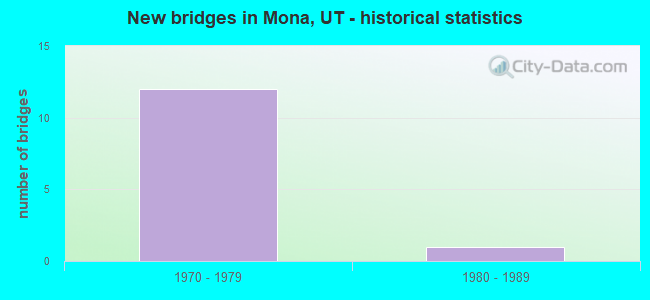
- New bridges - historical statistics
- 121970-1979
- 11980-1989


- Bridge Condition - Deck
- 14.3%Good
- 71.4%Satisfactory
- 14.3%Fair

- Bridge Condition - Superstructure
- 14.3%Good
- 85.7%Satisfactory

- Bridge Condition - Substructure
- 28.6%Good
- 71.4%Satisfactory
Find on map >> Show street view
Structure Number: 23002V, Location: NORTHWEST OF MONA (Lat: 39.820208, Lng: -111.867553), Route carried "on" structure: County highway 1828, Year Built: 1984, Status: Open, Structure Length: 0.61m (2.00ft), Average Daily Traffic: 519 (year 2020), Average Future Daily Traffic: 649 (year 2040), Design Load: HS 20+Mod, Features Intersected: CURRANT CREEK, Facility Carried by Structure: CNTY.ROAD,F.A.#274
Minimum Vertical Clearance: 30+ m (98+ ft), Kilometerpoint: 1.096, Lanes on structure: 2, Owner: County Highway Agency, Approaching Roadway Width: 10.4m (34.1ft), Material/Design: Steel, Design/Construction: Culvert, Number Of Spans In Main Unit: 1, Length of Maximum Span: 6.1m (20.0ft)
Condition: Channel: Good, Culverts: Good, Operating Rating: 97.2 metric tons, Method Used To Determine Operating Rating: Load and Resistance Factor Rating (LRFR) rating reported by rating factor(RF) method using HL-93 loadings, Inventory Rating: 96.9 metric tons, Method Used To Determine Inventory Rating: Load and Resistance Factor Rating (LRFR) rating reported by rating factor(RF) method using HL-93 loadings, Structural Evaluation: Better than present minimum criteria, Waterway Adequacy: Equal to present minimum criteria, Approach Roadway Alignment: Equal to present desirable criteria, Designated Inspection Frequency: Every 24 months, Inspection Date: March 2020
Find on map >> Show street view
Structure Number: F 325, Location: 1 MI.SO.MONA INTERCHANGE (Lat: 39.806900, Lng: -111.836314), Route carried "on" structure: County highway , Year Built: 1974, Status: Open, Structure Length: 8.49m (27.85ft), Average Daily Traffic: 500 (year 2020), Truck Traffic: 1%, Average Future Daily Traffic: 1,000 (year 2040), Design Load: HS 20+Mod, Features Intersected: I-15 (SR-15) NBL & S, Facility Carried by Structure: CO.RD.,UP&L AC
Minimum Vertical Clearance: 30+ m (98+ ft), Kilometerpoint: 1.121, Lanes on structure: 2, Lanes under structure: 4, Owner: State Highway Agency, Approaching Roadway Width: 8.7m (28.5ft), Skew: 1 degrees, Material/Design: Prestressed concrete continuous, Design/Construction: Stringer/Multi-beam, Number Of Spans In Main Unit: 4, Length of Maximum Span: 33.2m (108.9ft), Curb-To-Curb Width: 8.7m (28.5ft), Out-to-Out Width: 9.9m (32.5ft)
Condition: Deck: Good, Superstructure: Satisfactory, Substructure: Satisfactory, Operating Rating: 45.4 metric tons, Method Used To Determine Operating Rating: Load and Resistance Factor Rating (LRFR) rating reported by rating factor(RF) method using HL-93 loadings, Inventory Rating: 40.5 metric tons, Method Used To Determine Inventory Rating: Load Factor (LF) rating reported by rating factor (RF) method using MS18 loading, Structural Evaluation: Equal to present minimum criteria, Deck Geometry: Somewhat better than minimum adequacy, Underclear: Somewhat better than minimum adequacy, Approach Roadway Alignment: Equal to present desirable criteria, Designated Inspection Frequency: Every 24 months, Inspection Date: March 2021, Deck Structure Type: Concrete Cast-file-Place, Wearing Surface/Protective System: Wearing Surface: Bituminous, Membrane: Preformed Fabric
Find on map >> Show street view
Structure Number: 1C 606, Location: 2 MI. NO. OF MONA INTCHG. (Lat: 39.850294, Lng: -111.835581), Route carried "on" structure: Interstate 15, Year Built: 1974, Status: Open, Structure Length: 2.54m (8.33ft), Average Daily Traffic: 27,142 (year 2020), Truck Traffic: 25%, Average Future Daily Traffic: 33,928 (year 2040), Design Load: HS 20+Mod, Features Intersected: CO. RD. TO NORTH CANYON
Minimum Vertical Clearance: 30+ m (98+ ft), Kilometerpoint: 378.941, Lanes on structure: 2, Lanes under structure: 2, Base Highway Network: Yes, Owner: State Highway Agency, Approaching Roadway Width: 12.4m (40.7ft), Material/Design: Steel continuous, Design/Construction: Stringer/Multi-beam, Number Of Spans In Main Unit: 3, Length of Maximum Span: 10.8m (35.4ft), Curb-To-Curb Width: 12.4m (40.7ft), Out-to-Out Width: 13.5m (44.3ft)
Condition: Deck: Satisfactory, Superstructure: Satisfactory, Substructure: Satisfactory, Operating Rating: 35.0 metric tons, Method Used To Determine Operating Rating: Load and Resistance Factor Rating (LRFR) rating reported by rating factor(RF) method using HL-93 loadings, Inventory Rating: 30.5 metric tons, Method Used To Determine Inventory Rating: Load Factor (LF) rating reported by rating factor (RF) method using MS18 loading, Structural Evaluation: Equal to present minimum criteria, Deck Geometry: Better than present minimum criteria, Underclear: Meets minimum limits, Approach Roadway Alignment: Equal to present desirable criteria, Designated Inspection Frequency: Every 24 months, Inspection Date: March 2021, Deck Structure Type: Concrete Cast-file-Place, Wearing Surface/Protective System: Wearing Surface: Bituminous, Membrane: Preformed Fabric
Find on map >> Show street view
Structure Number: 1C 607, Location: MONA INTERCHANGE (Lat: 39.821206, Lng: -111.833319), Route carried "on" structure: Interstate 15, Year Built: 1974, Status: Open, Structure Length: 3.49m (11.45ft), Average Daily Traffic: 27,953 (year 2020), Truck Traffic: 26%, Average Future Daily Traffic: 34,941 (year 2040), Design Load: HS 20+Mod, Features Intersected: SR-54, INTCHG. X-ROAD
Minimum Vertical Clearance: 30+ m (98+ ft), Kilometerpoint: 375.699, Lanes on structure: 2, Lanes under structure: 2, Base Highway Network: Yes, Owner: State Highway Agency, Approaching Roadway Width: 12.4m (40.7ft), Material/Design: Steel continuous, Design/Construction: Stringer/Multi-beam, Number Of Spans In Main Unit: 3, Length of Maximum Span: 15.5m (50.9ft), Curb-To-Curb Width: 12.4m (40.7ft), Out-to-Out Width: 13.5m (44.3ft)
Condition: Deck: Satisfactory, Superstructure: Satisfactory, Substructure: Satisfactory, Operating Rating: 35.3 metric tons, Method Used To Determine Operating Rating: Load and Resistance Factor Rating (LRFR) rating reported by rating factor(RF) method using HL-93 loadings, Inventory Rating: 32.1 metric tons, Method Used To Determine Inventory Rating: Load and Resistance Factor Rating (LRFR) rating reported by rating factor(RF) method using HL-93 loadings, Structural Evaluation: Equal to present minimum criteria, Deck Geometry: Better than present minimum criteria, Underclear: Better than present minimum criteria, Approach Roadway Alignment: Equal to present desirable criteria, Designated Inspection Frequency: Every 24 months, Inspection Date: March 2021, Deck Structure Type: Concrete Cast-file-Place, Wearing Surface/Protective System: Wearing Surface: Bituminous, Membrane: Preformed Fabric
Find on map >> Show street view
Structure Number: 1C 61, Location: 2 Mi. S. of Mona Int. (Lat: 39.792844, Lng: -111.838381), Route carried "on" structure: Interstate 15, Year Built: 1974, Status: Open, Structure Length: 2.62m (8.60ft), Average Daily Traffic: 27,953 (year 2020), Truck Traffic: 26%, Average Future Daily Traffic: 34,941 (year 2040), Design Load: HS 20+Mod, Features Intersected: Deer Crossing
Minimum Vertical Clearance: 30+ m (98+ ft), Kilometerpoint: 372.510, Lanes on structure: 2, Base Highway Network: Yes, Owner: State Highway Agency, Approaching Roadway Width: 12.4m (40.7ft), Skew: 13 degrees, Material/Design: Steel continuous, Design/Construction: Stringer/Multi-beam, Number Of Spans In Main Unit: 3, Length of Maximum Span: 10.8m (35.4ft), Curb-To-Curb Width: 12.4m (40.7ft), Out-to-Out Width: 13.5m (44.3ft)
Condition: Deck: Satisfactory, Superstructure: Good, Substructure: Good, Operating Rating: 35.6 metric tons, Method Used To Determine Operating Rating: Load and Resistance Factor Rating (LRFR) rating reported by rating factor(RF) method using HL-93 loadings, Inventory Rating: 30.8 metric tons, Method Used To Determine Inventory Rating: Load and Resistance Factor Rating (LRFR) rating reported by rating factor(RF) method using HL-93 loadings, Structural Evaluation: Better than present minimum criteria, Deck Geometry: Better than present minimum criteria, Approach Roadway Alignment: Equal to present desirable criteria, Designated Inspection Frequency: Every 24 months, Inspection Date: March 2021, Deck Structure Type: Concrete Cast-file-Place, Wearing Surface/Protective System: Wearing Surface: Bituminous, Membrane: Preformed Fabric
Find on map >> Show street view
Structure Number: 3C 606, Location: 2 MI. NO. of MONA INTCHG. (Lat: 39.850603, Lng: -111.835972), Route carried "on" structure: Interstate 15, Year Built: 1974, Status: Open, Structure Length: 2.54m (8.33ft), Average Daily Traffic: 27,142 (year 2020), Truck Traffic: 25%, Average Future Daily Traffic: 33,928 (year 2040), Design Load: HS 20+Mod, Features Intersected: CO. RD. TO NORTH CANYON
Minimum Vertical Clearance: 30+ m (98+ ft), Kilometerpoint: 378.768, Lanes on structure: 2, Lanes under structure: 2, Base Highway Network: Yes, Owner: State Highway Agency, Approaching Roadway Width: 12.4m (40.7ft), Material/Design: Steel continuous, Design/Construction: Stringer/Multi-beam, Number Of Spans In Main Unit: 3, Length of Maximum Span: 10.8m (35.4ft), Curb-To-Curb Width: 12.4m (40.7ft), Out-to-Out Width: 13.5m (44.3ft)
Condition: Deck: Satisfactory, Superstructure: Satisfactory, Substructure: Satisfactory, Operating Rating: 36.3 metric tons, Method Used To Determine Operating Rating: Load and Resistance Factor Rating (LRFR) rating reported by rating factor(RF) method using HL-93 loadings, Inventory Rating: 30.5 metric tons, Method Used To Determine Inventory Rating: Load Factor (LF) rating reported by rating factor (RF) method using MS18 loading, Structural Evaluation: Equal to present minimum criteria, Deck Geometry: Better than present minimum criteria, Underclear: Meets minimum limits, Approach Roadway Alignment: Equal to present desirable criteria, Designated Inspection Frequency: Every 24 months, Inspection Date: March 2021, Deck Structure Type: Concrete Cast-file-Place, Wearing Surface/Protective System: Wearing Surface: Bituminous, Membrane: Preformed Fabric
Find on map >> Show street view
Structure Number: 3C 607, Location: MONA INTERCHANGE (Lat: 39.821572, Lng: -111.833761), Route carried "on" structure: Interstate 15, Year Built: 1974, Status: Open, Structure Length: 3.49m (11.45ft), Average Daily Traffic: 27,953 (year 2020), Truck Traffic: 26%, Average Future Daily Traffic: 34,941 (year 2040), Design Load: HS 20+Mod, Features Intersected: SR-54, INTCHG. X-ROAD
Minimum Vertical Clearance: 30+ m (98+ ft), Kilometerpoint: 375.533, Lanes on structure: 2, Lanes under structure: 2, Base Highway Network: Yes, Owner: State Highway Agency, Approaching Roadway Width: 12.4m (40.7ft), Material/Design: Steel continuous, Design/Construction: Stringer/Multi-beam, Number Of Spans In Main Unit: 3, Length of Maximum Span: 15.5m (50.9ft), Curb-To-Curb Width: 12.4m (40.7ft), Out-to-Out Width: 13.6m (44.6ft)
Condition: Deck: Fair, Superstructure: Satisfactory, Substructure: Satisfactory, Operating Rating: 35.3 metric tons, Method Used To Determine Operating Rating: Load and Resistance Factor Rating (LRFR) rating reported by rating factor(RF) method using HL-93 loadings, Inventory Rating: 32.1 metric tons, Method Used To Determine Inventory Rating: Load and Resistance Factor Rating (LRFR) rating reported by rating factor(RF) method using HL-93 loadings, Structural Evaluation: Equal to present minimum criteria, Deck Geometry: Better than present minimum criteria, Underclear: Better than present minimum criteria, Approach Roadway Alignment: Equal to present desirable criteria, Designated Inspection Frequency: Every 24 months, Inspection Date: March 2021, Deck Structure Type: Concrete Cast-file-Place, Wearing Surface/Protective System: Wearing Surface: Bituminous, Membrane: Preformed Fabric
Find on map >> Show street view
Structure Number: 3C 61, Location: 2 MI.SO.MONA INTERCHANGE (Lat: 39.792842, Lng: -111.838831), Route carried "on" structure: Interstate 15, Year Built: 1974, Status: Open, Structure Length: 2.62m (8.60ft), Average Daily Traffic: 27,953 (year 2020), Truck Traffic: 26%, Average Future Daily Traffic: 34,941 (year 2040), Design Load: HS 20+Mod, Features Intersected: DEER CROSSING
Minimum Vertical Clearance: 30+ m (98+ ft), Kilometerpoint: 372.303, Lanes on structure: 2, Base Highway Network: Yes, Owner: State Highway Agency, Approaching Roadway Width: 12.4m (40.7ft), Skew: 3 degrees, Material/Design: Steel continuous, Design/Construction: Stringer/Multi-beam, Number Of Spans In Main Unit: 3, Length of Maximum Span: 10.8m (35.4ft), Curb-To-Curb Width: 12.4m (40.7ft), Out-to-Out Width: 13.6m (44.6ft)
Condition: Deck: Satisfactory, Superstructure: Satisfactory, Substructure: Good, Operating Rating: 35.6 metric tons, Method Used To Determine Operating Rating: Load and Resistance Factor Rating (LRFR) rating reported by rating factor(RF) method using HL-93 loadings, Inventory Rating: 30.8 metric tons, Method Used To Determine Inventory Rating: Load and Resistance Factor Rating (LRFR) rating reported by rating factor(RF) method using HL-93 loadings, Structural Evaluation: Equal to present minimum criteria, Deck Geometry: Better than present minimum criteria, Approach Roadway Alignment: Equal to present desirable criteria, Designated Inspection Frequency: Every 24 months, Inspection Date: March 2021, Deck Structure Type: Concrete Cast-file-Place, Wearing Surface/Protective System: Wearing Surface: Bituminous, Membrane: Preformed Fabric
Find on map >> Show street view
Structure Number: F 325, Location: 1 MI.SO.MONA INTERCHANGE (Lat: 39.806900, Lng: -111.836314), Route carried "under" structure: Interstate 15, Year Built: 1974, Structure Length: 0. m, Average Daily Traffic: 27,953 (year 2020), Truck Traffic: 26%, Features Intersected: I-15 (SR-15) NBL & S, Facility Carried by Structure: CO.RD.,UP&L AC
Minimum Vertical Clearance: 5.08m (16.67ft), Kilometerpoint: 373.638, Lanes on structure: 2, Lanes under structure: 4, Material/Design: Prestressed concrete continuous, Design/Construction: Stringer/Multi-beam, Length of Maximum Span: 33.2m (108.9ft)
Find on map >> Show street view
Structure Number: 1C 606, Location: 2 MI. NO. OF MONA INTCHG. (Lat: 39.850294, Lng: -111.835581), Route carried "under" structure: County highway , Year Built: 1974, Structure Length: 0. m, Features Intersected: CO. RD. TO NORTH CANYON, Facility Carried by Structure: I-15 (SR-15) NBL
Minimum Vertical Clearance: 4.54m (14.90ft), Kilometerpoint: 0.000, Lanes on structure: 2, Lanes under structure: 2, Material/Design: Steel continuous, Design/Construction: Stringer/Multi-beam, Length of Maximum Span: 10.8m (35.4ft)
Find on map >> Show street view
Structure Number: 1C 607, Location: MONA INTERCHANGE (Lat: 39.821206, Lng: -111.833319), Route carried "under" structure: State highway 54, Year Built: 1974, Structure Length: 0. m, Average Daily Traffic: 2,476 (year 2020), Truck Traffic: 26%, Features Intersected: SR-54, INTCHG. X-ROAD, Facility Carried by Structure: I-15 (SR-15) NBL
Minimum Vertical Clearance: 4.93m (16.17ft), Kilometerpoint: 4.947, Lanes on structure: 2, Lanes under structure: 2, Material/Design: Steel continuous, Design/Construction: Stringer/Multi-beam, Length of Maximum Span: 15.5m (50.9ft)
Find on map >> Show street view
Structure Number: 3C 606, Location: 2 MI. NO. of MONA INTCHG. (Lat: 39.850603, Lng: -111.835972), Route carried "under" structure: County highway , Year Built: 1974, Structure Length: 0. m, Features Intersected: CO. RD. TO NORTH CANYON, Facility Carried by Structure: I-15 (SR-15) SBL
Minimum Vertical Clearance: 4.75m (15.58ft), Kilometerpoint: 0.000, Lanes on structure: 2, Lanes under structure: 2, Material/Design: Steel continuous, Design/Construction: Stringer/Multi-beam, Length of Maximum Span: 10.8m (35.4ft)
Find on map >> Show street view
Structure Number: 3C 607, Location: MONA INTERCHANGE (Lat: 39.821572, Lng: -111.833761), Route carried "under" structure: State highway 54, Year Built: 1974, Structure Length: 0. m, Average Daily Traffic: 2,476 (year 2020), Truck Traffic: 26%, Features Intersected: SR-54, INTCHG. X-ROAD, Facility Carried by Structure: I-15 (SR-15) SBL
Minimum Vertical Clearance: 4.90m (16.08ft), Kilometerpoint: 1.947, Lanes on structure: 2, Lanes under structure: 2, Material/Design: Steel continuous, Design/Construction: Stringer/Multi-beam, Length of Maximum Span: 15.5m (50.9ft)