Bridge Statistics for Monahans, Texas (TX)
Condition, Traffic, Stress, Structural Evaluation, Project Costs
- National Bridge Inventory (NBI) Statistics
- 15Number of bridges
- 141ft / 42.9mTotal length
- $18,000Total costs
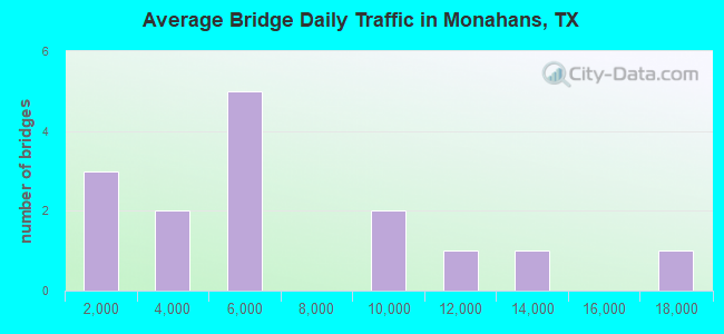
- 95,880Total average daily traffic
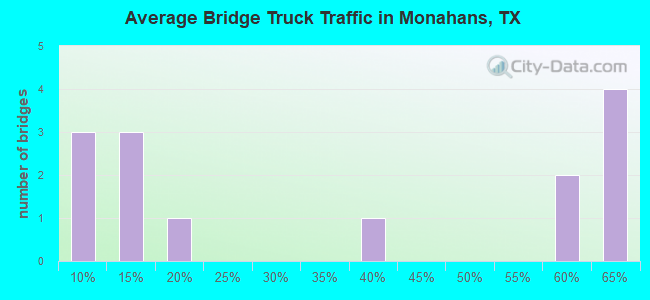
- 28,376Total average daily truck traffic
- National Bridge Inventory (NBI) Registered Bridges for Monahans
- No street view available for this location
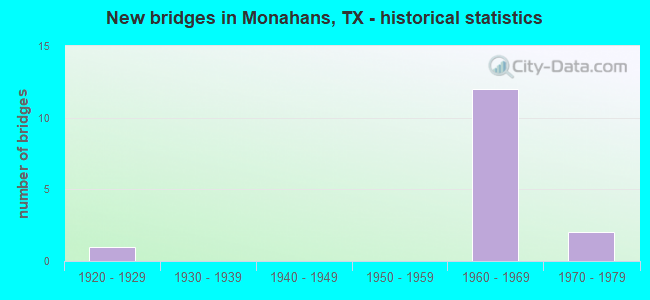
- New bridges - historical statistics
- 11920-1929
- 121960-1969
- 21970-1979
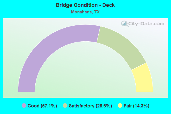
- Bridge Condition - Deck
- 57.1%Good
- 28.6%Satisfactory
- 14.3%Fair

- Bridge Condition - Superstructure
- 57.1%Good
- 28.6%Satisfactory
- 14.3%Fair
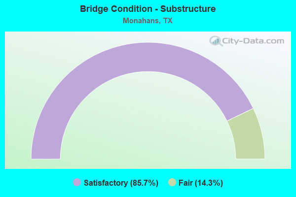
- Bridge Condition - Substructure
- 85.7%Satisfactory
- 14.3%Fair
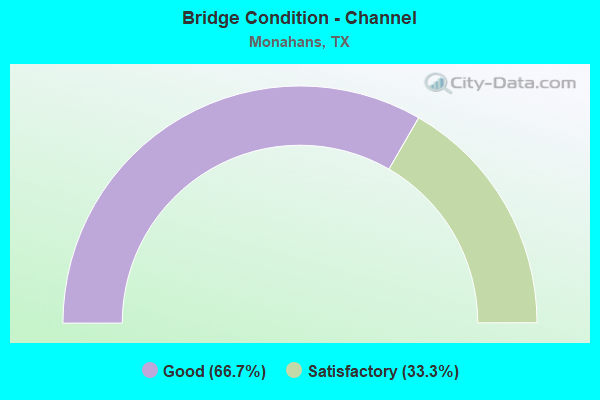
- Bridge Condition - Channel
- 66.7%Good
- 33.3%Satisfactory
Find on map >> Show street view
Structure Number: 62380000401002, Location: 0.55 Mi E of Reeves C/L (Lat: 31.439497, Lng: -103.458033), Route carried "on" structure: Business State highway 20, Year Built: 1927, Year Reconstructed: 1962, Status: Open, Structure Length: 4.69m (15.39ft), Average Daily Traffic: 3,730 (year 2013), Truck Traffic: 5%, Average Future Daily Traffic: 5,230 (year 2033), Design Load: H 15, Features Intersected: Pecos River Relief
Minimum Vertical Clearance: 30+ m (98+ ft), Kilometerpoint: 17.041, Lanes on structure: 2, Owner: State Highway Agency, Approaching Roadway Width: 13.4m (44.0ft), Material/Design: Concrete, Design/Construction: Slab, Number Of Spans In Main Unit: 11, Length of Maximum Span: 4.3m (14.1ft), Curb-To-Curb Width: 13.3m (43.6ft), Out-to-Out Width: 13.8m (45.3ft)
Condition: Deck: Fair, Superstructure: Fair, Substructure: Fair, Channel: Good, Operating Rating: 33.6 metric tons, Method Used To Determine Operating Rating: Load Factor (LF), Inventory Rating: 20.0 metric tons, Method Used To Determine Inventory Rating: Load Factor (LF), Structural Evaluation: Somewhat better than minimum adequacy, Deck Geometry: Equal to present minimum criteria, Waterway Adequacy: Equal to present minimum criteria, Approach Roadway Alignment: Equal to present desirable criteria, Length Of Structure Improvement: 4.69m (15.39ft), Designated Inspection Frequency: Every 24 months, Inspection Date: September 2021, Bridge Improvement Cost: $14,000, Roadway Improvement Cost: $4,000, Total Project Cost: $18,000, Deck Structure Type: Concrete Cast-file-Place, Wearing Surface/Protective System: Wearing Surface: Bituminous
Find on map >> Show street view
Structure Number: 6238000040403, Location: 2.75 MI W of LP 464 (Lat: 31.572153, Lng: -102.955950), Route carried "on" structure: Business State highway 20, Year Built: 1964, Status: Open, Structure Length: 7.07m (23.20ft), Average Daily Traffic: 360 (year 2015), Average Future Daily Traffic: 75 (year 2035), Design Load: H 20, Features Intersected: IH 20
Minimum Vertical Clearance: 30+ m (98+ ft), Kilometerpoint: 0.000, Lanes on structure: 2, Lanes under structure: 4, Owner: State Highway Agency, Approaching Roadway Width: 10.1m (33.1ft), Skew: 3 degrees, Material/Design: Prestressed concrete, Design/Construction: Stringer/Multi-beam, Number Of Spans In Main Unit: 2, Number Of Approach Spans: 2, Length of Maximum Span: 21.0m (68.9ft), Curb-To-Curb Width: 9.1m (29.9ft), Out-to-Out Width: 10.1m (33.1ft)
Condition: Deck: Satisfactory, Superstructure: Satisfactory, Substructure: Satisfactory, Operating Rating: 59.9 metric tons, Method Used To Determine Operating Rating: Load Factor (LF), Inventory Rating: 28.1 metric tons, Method Used To Determine Inventory Rating: Load Factor (LF), Structural Evaluation: Equal to present minimum criteria, Deck Geometry: Equal to present minimum criteria, Underclear: Meets minimum limits, Approach Roadway Alignment: Equal to present desirable criteria, Designated Inspection Frequency: Every 24 months, Inspection Date: September 2021, Deck Structure Type: Concrete Cast-file-Place, Wearing Surface/Protective System: Wearing Surface: Bituminous
Find on map >> Show street view
Structure Number: 62380000404031, Location: IH 20 @ SH 18 (Lat: 31.575106, Lng: -102.891881), Route carried "on" structure: Interstate 20, Year Built: 1964, Status: Open, Structure Length: 5.55m (18.21ft), Average Daily Traffic: 5,440 (year 2013), Truck Traffic: 62%, Average Future Daily Traffic: 7,620 (year 2033), Design Load: HS 20, Features Intersected: SH 18
Minimum Vertical Clearance: 30+ m (98+ ft), Kilometerpoint: 50.791, Lanes on structure: 2, Lanes under structure: 4, Owner: State Highway Agency, Approaching Roadway Width: 11.6m (38.1ft), Skew: 2 degrees, Material/Design: Prestressed concrete, Design/Construction: Stringer/Multi-beam, Number Of Spans In Main Unit: 4, Length of Maximum Span: 13.7m (44.9ft), Curb-To-Curb Width: 11.3m (37.1ft), Out-to-Out Width: 12.3m (40.4ft)
Condition: Deck: Good, Superstructure: Good, Substructure: Satisfactory, Operating Rating: 68.0 metric tons, Method Used To Determine Operating Rating: Load Factor (LF), Inventory Rating: 39.0 metric tons, Method Used To Determine Inventory Rating: Load Factor (LF), Structural Evaluation: Equal to present minimum criteria, Deck Geometry: Somewhat better than minimum adequacy, Underclear: High priority of corrective action, Approach Roadway Alignment: Equal to present desirable criteria, Designated Inspection Frequency: Every 24 months, Inspection Date: September 2021, Deck Structure Type: Concrete Cast-file-Place, Wearing Surface/Protective System: Wearing Surface: Bituminous
Find on map >> Show street view
Structure Number: 62380000404032, Location: IH 20 @ SH 18 (Lat: 31.574911, Lng: -102.891894), Route carried "on" structure: Interstate 20, Year Built: 1964, Status: Open, Structure Length: 5.55m (18.21ft), Average Daily Traffic: 5,440 (year 2013), Truck Traffic: 62%, Average Future Daily Traffic: 7,620 (year 2033), Design Load: HS 20, Features Intersected: SH 18
Minimum Vertical Clearance: 30+ m (98+ ft), Kilometerpoint: 50.791, Lanes on structure: 2, Lanes under structure: 4, Owner: State Highway Agency, Approaching Roadway Width: 11.6m (38.1ft), Skew: 2 degrees, Material/Design: Prestressed concrete, Design/Construction: Stringer/Multi-beam, Number Of Spans In Main Unit: 4, Length of Maximum Span: 13.7m (44.9ft), Curb-To-Curb Width: 11.3m (37.1ft), Out-to-Out Width: 12.3m (40.4ft)
Condition: Deck: Good, Superstructure: Good, Substructure: Satisfactory, Operating Rating: 68.0 metric tons, Method Used To Determine Operating Rating: Load Factor (LF), Inventory Rating: 39.0 metric tons, Method Used To Determine Inventory Rating: Load Factor (LF), Structural Evaluation: Equal to present minimum criteria, Deck Geometry: Somewhat better than minimum adequacy, Underclear: High priority of corrective action, Approach Roadway Alignment: Equal to present desirable criteria, Designated Inspection Frequency: Every 24 months, Inspection Date: September 2021, Deck Structure Type: Concrete Cast-file-Place, Wearing Surface/Protective System: Wearing Surface: Bituminous
Find on map >> Show street view
Structure Number: 62380000404033, Location: IH 20 BUS@ IH 20 (Lat: 31.606397, Lng: -102.845631), Route carried "on" structure: Interstate 20, Year Built: 1964, Status: Open, Structure Length: 5.09m (16.70ft), Average Daily Traffic: 5,440 (year 2013), Truck Traffic: 62%, Average Future Daily Traffic: 7,620 (year 2033), Design Load: HS 20, Features Intersected: IH 20 BUS
Minimum Vertical Clearance: 30+ m (98+ ft), Kilometerpoint: 56.950, Lanes on structure: 2, Lanes under structure: 2, Owner: State Highway Agency, Approaching Roadway Width: 11.6m (38.1ft), Skew: 4 degrees, Material/Design: Prestressed concrete, Design/Construction: Stringer/Multi-beam, Number Of Spans In Main Unit: 3, Length of Maximum Span: 19.8m (65.0ft), Curb-To-Curb Width: 11.3m (37.1ft), Out-to-Out Width: 12.3m (40.4ft)
Condition: Deck: Good, Superstructure: Good, Substructure: Satisfactory, Operating Rating: 58.0 metric tons, Method Used To Determine Operating Rating: Load Factor (LF), Inventory Rating: 29.0 metric tons, Method Used To Determine Inventory Rating: Load Factor (LF), Structural Evaluation: Equal to present minimum criteria, Deck Geometry: Somewhat better than minimum adequacy, Underclear: Somewhat better than minimum adequacy, Approach Roadway Alignment: Equal to present desirable criteria, Designated Inspection Frequency: Every 24 months, Inspection Date: September 2021, Deck Structure Type: Concrete Cast-file-Place, Wearing Surface/Protective System: Wearing Surface: Bituminous
Find on map >> Show street view
Structure Number: 62380000404034, Location: IH 20 Bus @ IH 20 (Lat: 31.606064, Lng: -102.845756), Route carried "on" structure: Interstate 20, Year Built: 1964, Status: Open, Structure Length: 5.09m (16.70ft), Average Daily Traffic: 5,440 (year 2013), Truck Traffic: 62%, Average Future Daily Traffic: 7,620 (year 2033), Design Load: HS 20, Features Intersected: IH 20 BUS
Minimum Vertical Clearance: 30+ m (98+ ft), Kilometerpoint: 56.950, Lanes on structure: 2, Lanes under structure: 2, Owner: State Highway Agency, Approaching Roadway Width: 11.6m (38.1ft), Skew: 4 degrees, Material/Design: Prestressed concrete, Design/Construction: Stringer/Multi-beam, Number Of Spans In Main Unit: 3, Length of Maximum Span: 19.8m (65.0ft), Curb-To-Curb Width: 11.3m (37.1ft), Out-to-Out Width: 12.3m (40.4ft)
Condition: Deck: Good, Superstructure: Good, Substructure: Satisfactory, Operating Rating: 58.0 metric tons, Method Used To Determine Operating Rating: Load Factor (LF), Inventory Rating: 29.0 metric tons, Method Used To Determine Inventory Rating: Load Factor (LF), Structural Evaluation: Equal to present minimum criteria, Deck Geometry: Somewhat better than minimum adequacy, Underclear: Somewhat better than minimum adequacy, Approach Roadway Alignment: Equal to present desirable criteria, Designated Inspection Frequency: Every 24 months, Inspection Date: September 2021, Deck Structure Type: Concrete Cast-file-Place, Wearing Surface/Protective System: Wearing Surface: Bituminous
Find on map >> Show street view
Structure Number: 62380000404035, Location: 1.5 MI W. of SH 18 (Lat: 31.572725, Lng: -102.909767), Route carried "on" structure: State highway 464, Year Built: 1965, Status: Open, Structure Length: 7.92m (25.98ft), Average Daily Traffic: 3,870 (year 2013), Truck Traffic: 56%, Average Future Daily Traffic: 5,420 (year 2033), Design Load: HS 20, Features Intersected: IH 20
Minimum Vertical Clearance: 30+ m (98+ ft), Kilometerpoint: 13.235, Lanes on structure: 2, Lanes under structure: 4, Owner: State Highway Agency, Approaching Roadway Width: 10.1m (33.1ft), Skew: 2 degrees, Material/Design: Prestressed concrete, Design/Construction: Stringer/Multi-beam, Number Of Spans In Main Unit: 4, Length of Maximum Span: 21.3m (69.9ft), Curb-To-Curb Width: 10.1m (33.1ft), Out-to-Out Width: 10.8m (35.4ft)
Condition: Deck: Satisfactory, Superstructure: Satisfactory, Substructure: Satisfactory, Operating Rating: 67.1 metric tons, Method Used To Determine Operating Rating: Load Factor (LF), Inventory Rating: 29.9 metric tons, Method Used To Determine Inventory Rating: Load Factor (LF), Structural Evaluation: Equal to present minimum criteria, Deck Geometry: Meets minimum limits, Underclear: Meets minimum limits, Approach Roadway Alignment: Equal to present desirable criteria, Designated Inspection Frequency: Every 24 months, Inspection Date: September 2021, Deck Structure Type: Concrete Cast-file-Place, Wearing Surface/Protective System: Wearing Surface: Bituminous
Find on map >> Show street view
Structure Number: 62380000404077, Location: 0.50 MI W OF SH 18 (Lat: 31.573039, Lng: -102.900389), Route carried "on" structure: Interstate 20, Year Built: 1971, Status: Open, Structure Length: 0.98m (3.22ft), Average Daily Traffic: 17,950 (year 2020), Truck Traffic: 11%, Average Future Daily Traffic: 11,790 (year 2033), Design Load: HS 20, Features Intersected: ARROYO CARRASCO
Minimum Vertical Clearance: 30+ m (98+ ft), Kilometerpoint: 50.409, Lanes on structure: 8, Owner: State Highway Agency, Approaching Roadway Width: 41.5m (136.2ft), Skew: 20 degrees, Material/Design: Concrete, Design/Construction: Culvert, Number Of Spans In Main Unit: 3, Length of Maximum Span: 3.0m (9.8ft)
Condition: Channel: Satisfactory, Culverts: Satisfactory, Operating Rating: 39.9 metric tons, Method Used To Determine Operating Rating: Load Factor (LF), Inventory Rating: 23.6 metric tons, Method Used To Determine Inventory Rating: Load Factor (LF), Structural Evaluation: Somewhat better than minimum adequacy, Waterway Adequacy: Superior to present desirable criteria, Approach Roadway Alignment: Equal to present desirable criteria, Designated Inspection Frequency: Every 24 months, Inspection Date: September 2020
Find on map >> Show street view
Structure Number: 62380029207017, Location: 0.75 MI S OF IH 20 (Lat: 31.562100, Lng: -102.905881), Route carried "on" structure: State highway 464, Year Built: 1974, Status: Open, Structure Length: 0.91m (2.99ft), Average Daily Traffic: 5,510 (year 2020), Truck Traffic: 56%, Average Future Daily Traffic: 4,900 (year 2033), Design Load: HS 20, Features Intersected: DRAIN
Minimum Vertical Clearance: 30+ m (98+ ft), Kilometerpoint: 14.503, Lanes on structure: 2, Owner: State Highway Agency, Approaching Roadway Width: 14.6m (47.9ft), Material/Design: Concrete, Design/Construction: Culvert, Number Of Spans In Main Unit: 4, Length of Maximum Span: 2.1m (6.9ft), Out-to-Out Width: 27.2m (89.2ft)
Condition: Channel: Good, Culverts: Satisfactory, Operating Rating: 39.9 metric tons, Method Used To Determine Operating Rating: Load Factor (LF), Inventory Rating: 23.6 metric tons, Method Used To Determine Inventory Rating: Load Factor (LF), Structural Evaluation: Somewhat better than minimum adequacy, Waterway Adequacy: Better than present minimum criteria, Approach Roadway Alignment: Equal to present desirable criteria, Designated Inspection Frequency: Every 24 months, Inspection Date: April 2021
Find on map >> Show street view
Structure Number: 6238000040403, Location: 2.75 MI W of LP 464 (Lat: 31.572153, Lng: -102.955950), Route carried "under" structure: Interstate 20, Year Built: 1964, Structure Length: 0. m, Average Daily Traffic: 8,550 (year 2013), Truck Traffic: 15%, Features Intersected: IH 20
Minimum Vertical Clearance: 5.46m (17.91ft), Kilometerpoint: 45.050, Lanes on structure: 2, Lanes under structure: 4, Material/Design: Prestressed concrete, Design/Construction: Stringer/Multi-beam, Length of Maximum Span: 21.0m (68.9ft)
Find on map >> Show street view
Structure Number: 62380000404031, Location: IH 20 @ SH 18 (Lat: 31.575106, Lng: -102.891881), Route carried "under" structure: State highway 18, Year Built: 1964, Structure Length: 0. m, Average Daily Traffic: 10,550 (year 2013), Truck Traffic: 35%, Features Intersected: SH 18, Facility Carried by Structure: IH 20 WB
Minimum Vertical Clearance: 5.13m (16.83ft), Kilometerpoint: 16.283, Lanes on structure: 2, Lanes under structure: 4, Material/Design: Prestressed concrete, Design/Construction: Stringer/Multi-beam, Length of Maximum Span: 13.7m (44.9ft)
Find on map >> Show street view
Structure Number: 62380000404032, Location: IH 20 @ SH 18 (Lat: 31.574911, Lng: -102.891894), Route carried "under" structure: State highway 18, Year Built: 1964, Structure Length: 0. m, Average Daily Traffic: 12,880 (year 2013), Truck Traffic: 11%, Features Intersected: SH 18, Facility Carried by Structure: IH 20 EB
Minimum Vertical Clearance: 5.18m (16.99ft), Kilometerpoint: 16.316, Lanes on structure: 2, Lanes under structure: 4, Material/Design: Prestressed concrete, Design/Construction: Stringer/Multi-beam, Length of Maximum Span: 13.7m (44.9ft)
Find on map >> Show street view
Structure Number: 62380000404033, Location: IH 20 BUS@ IH 20 (Lat: 31.606397, Lng: -102.845631), Route carried "under" structure: Business State highway 20, Year Built: 1964, Structure Length: 0. m, Average Daily Traffic: 1,150 (year 2013), Truck Traffic: 7%, Features Intersected: IH 20 BUS
Minimum Vertical Clearance: 5.31m (17.42ft), Kilometerpoint: 33.326, Lanes on structure: 2, Lanes under structure: 2, Material/Design: Prestressed concrete, Design/Construction: Stringer/Multi-beam, Length of Maximum Span: 19.8m (65.0ft)
Find on map >> Show street view
Structure Number: 62380000404034, Location: IH 20 Bus @ IH 20 (Lat: 31.606064, Lng: -102.845756), Route carried "under" structure: Business State highway 20, Year Built: 1964, Structure Length: 0. m, Average Daily Traffic: 1,150 (year 2013), Truck Traffic: 7%, Features Intersected: IH 20
Minimum Vertical Clearance: 5.03m (16.50ft), Kilometerpoint: 33.379, Lanes on structure: 2, Lanes under structure: 2, Material/Design: Prestressed concrete, Design/Construction: Stringer/Multi-beam, Length of Maximum Span: 19.8m (65.0ft)
Find on map >> Show street view
Structure Number: 62380000404035, Location: 1.5 MI W. of SH 18 (Lat: 31.572725, Lng: -102.909767), Route carried "under" structure: Interstate 20, Year Built: 1965, Structure Length: 0. m, Average Daily Traffic: 8,420 (year 2013), Truck Traffic: 11%, Features Intersected: IH 20, Facility Carried by Structure: LP 464 (Monahans)
Minimum Vertical Clearance: 5.26m (17.26ft), Kilometerpoint: 49.516, Lanes on structure: 2, Lanes under structure: 4, Material/Design: Prestressed concrete, Design/Construction: Stringer/Multi-beam, Length of Maximum Span: 21.3m (69.9ft)