Bridge Statistics for Montague, Michigan (MI)
Condition, Traffic, Stress, Structural Evaluation, Project Costs
- National Bridge Inventory (NBI) Statistics
- 16Number of bridges
- 118ft / 36.2mTotal length
- 68,602Total average daily traffic
- 3,627Total average daily truck traffic
- National Bridge Inventory (NBI) Registered Bridges for Montague
- No street view available for this location
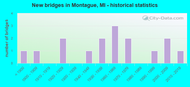
- New bridges - historical statistics
- 1Before 1900
- 11900-1909
- 21920-1929
- 11940-1949
- 21950-1959
- 31960-1969
- 21970-1979
- 11990-1999
- 22000-2009
- 12010-2019

- Reconstructed bridges - Historical Statistics
- 31970-1979
- 01980-1989
- 11990-1999


- Bridge Condition - Deck
- 38.5%Good
- 46.2%Satisfactory
- 7.7%Fair
- 7.7%Serious

- Bridge Condition - Superstructure
- 46.2%Good
- 15.4%Satisfactory
- 30.8%Fair
- 7.7%Poor

- Bridge Condition - Substructure
- 7.7%Very good
- 23.1%Good
- 46.2%Satisfactory
- 15.4%Fair
- 7.7%Poor

- Bridge Condition - Channel
- 23.1%Very good
- 38.5%Good
- 23.1%Satisfactory
- 7.7%Fair
- 7.7%Poor
Find on map >> Show street view
Structure Number: 314, Location: CITY OF ALLEGAN (Lat: 42.526003, Lng: -85.848358), Route carried "on" structure: Business City street , Year Built: 1886, Year Reconstructed: 1982, Status: Posted for load, Structure Length: 6.98m (22.90ft), Average Daily Traffic: 2,582 (year 2006), Average Future Daily Traffic: 3,826 (year 2026), Design Load: H 15, Features Intersected: KALAMAZOO RIVER, Facility Carried by Structure: SECOND STREET
Minimum Vertical Clearance: 5.49m (18.01ft), Kilometerpoint: 0.166, Lanes on structure: 1, Owner: City or Municipal Highway Agency, Approaching Roadway Width: 7.6m (24.9ft), Material/Design: Steel, Design/Construction: Truss - Thru, Number Of Spans In Main Unit: 1, Length of Maximum Span: 69.8m (229.0ft), Curb or Sidewalk Widths: Left: 1.8m (5.9ft), Right: 0.0m, Curb-To-Curb Width: 4.9m (16.1ft), Out-to-Out Width: 5.4m (17.7ft)
Condition: Deck: Satisfactory, Superstructure: Fair, Substructure: Satisfactory, Channel: Good, Operating Rating: 5.5 metric tons, Method Used To Determine Operating Rating: Load Factor (LF) rating reported by rating factor (RF) method using MS18 loading, Inventory Rating: 3.2 metric tons, Method Used To Determine Inventory Rating: Load Factor (LF) rating reported by rating factor (RF) method using MS18 loading, Structural Evaluation: High priority of corrective action, Deck Geometry: High priority of replacement, Waterway Adequacy: Equal to present desirable criteria, Approach Roadway Alignment: High priority of corrective action, Bridge Posting: Required (Relationship of Operating Rating to Maximum Legal Load: > 39.9% below), Designated Inspection Frequency: Every 24 months, Critical Feature Inspection Frequency: Every 24 months, Inspection Date: October 2021, Critical Feature Inspection Date: October 2021, Deck Structure Type: Wood or Timber, Wearing Surface/Protective System: Wearing Surface: Wood or Timber
Find on map >> Show street view
Structure Number: 3657, Location: SEC. 10-11 SEBEWAING TWP. (Lat: 43.727264, Lng: -83.395953), Route carried "on" structure: ServiceCounty highway , Year Built: 1927, Status: Posted for load, Structure Length: 0.91m (2.99ft), Average Daily Traffic: 100 (year 2009), Truck Traffic: 1%, Average Future Daily Traffic: 180 (year 2029), Design Load: H 15, Features Intersected: COLUMBIA DRAIN, Facility Carried by Structure: GETTEL ROAD
Minimum Vertical Clearance: 30.48m (100.00ft), Kilometerpoint: 6.479, Lanes on structure: 2, Owner: County Highway Agency, Approaching Roadway Width: 9.8m (32.2ft), Material/Design: Steel, Design/Construction: Stringer/Multi-beam, Number Of Spans In Main Unit: 1, Length of Maximum Span: 8.5m (27.9ft), Curb-To-Curb Width: 6.1m (20.0ft), Out-to-Out Width: 6.2m (20.3ft)
Condition: Deck: Satisfactory, Superstructure: Good, Substructure: Satisfactory, Channel: Very good, Operating Rating: 26.9 metric tons, Method Used To Determine Operating Rating: Load Factor (LF) rating reported by rating factor (RF) method using MS18 loading, Inventory Rating: 16.2 metric tons, Method Used To Determine Inventory Rating: Load Factor (LF) rating reported by rating factor (RF) method using MS18 loading, Structural Evaluation: Somewhat better than minimum adequacy, Deck Geometry: Somewhat better than minimum adequacy, Waterway Adequacy: Equal to present desirable criteria, Approach Roadway Alignment: Equal to present desirable criteria, Bridge Posting: Required (Relationship of Operating Rating to Maximum Legal Load: > 39.9% below), Designated Inspection Frequency: Every 24 months, Inspection Date: October 2021, Deck Structure Type: Concrete Cast-file-Place, Wearing Surface/Protective System: Wearing Surface: Monolithic Concrete
Find on map >> Show street view
Structure Number: 7384, Location: 0.7 MI S OF CONE ROAD (Lat: 42.023831, Lng: -83.693808), Route carried "on" structure: County highway , Year Built: 1950, Year Reconstructed: 1990, Status: Open, Structure Length: 0.94m (3.08ft), Average Daily Traffic: 214 (year 1981), Truck Traffic: 8%, Average Future Daily Traffic: 250 (year 2020), Design Load: HS 20, Features Intersected: BEAR SWAMP CREEK, Facility Carried by Structure: PLATT ROAD
Minimum Vertical Clearance: 30.48m (100.00ft), Kilometerpoint: 3.002, Lanes on structure: 2, Owner: County Highway Agency, Approaching Roadway Width: 6.1m (20.0ft), Skew: 3 degrees, Material/Design: Prestressed concrete, Design/Construction: Box Beam or Girders - Multiple, Number Of Spans In Main Unit: 1, Length of Maximum Span: 9.1m (29.9ft), Curb-To-Curb Width: 6.4m (21.0ft), Out-to-Out Width: 6.5m (21.3ft)
Condition: Deck: Satisfactory, Superstructure: Satisfactory, Substructure: Fair, Channel: Poor, Operating Rating: 72.3 metric tons, Method Used To Determine Operating Rating: Load Factor (LF) rating reported by rating factor (RF) method using MS18 loading, Inventory Rating: 43.1 metric tons, Method Used To Determine Inventory Rating: Load Factor (LF) rating reported by rating factor (RF) method using MS18 loading, Structural Evaluation: Somewhat better than minimum adequacy, Deck Geometry: Meets minimum limits, Waterway Adequacy: Equal to present desirable criteria, Approach Roadway Alignment: Equal to present minimum criteria, Designated Inspection Frequency: Every 24 months, Inspection Date: November 2020, Deck Structure Type: Concrete Precast Panels, Wearing Surface/Protective System: Wearing Surface: Gravel
Find on map >> Show street view
Structure Number: 7608, Location: N JCT US-31 BR (Lat: 43.443481, Lng: -86.338661), Route carried "on" structure: US 31, Year Built: 1965, Status: Open, Structure Length: 3.38m (11.09ft), Average Daily Traffic: 8,086 (year 2007), Truck Traffic: 9%, Average Future Daily Traffic: 7,766 (year 2018), Design Load: HS 20, Features Intersected: US-31 BR (FRUITVALE RD)
Minimum Vertical Clearance: 30.48m (100.00ft), Kilometerpoint: 40.206, Lanes on structure: 3, Lanes under structure: 2, Base Highway Network: Yes (Inventory Route: 85, Subroute: 9), Owner: State Highway Agency, Approaching Roadway Width: 13.7m (44.9ft), Material/Design: Steel, Design/Construction: Stringer/Multi-beam, Number Of Spans In Main Unit: 3, Length of Maximum Span: 13.1m (43.0ft), Curb or Sidewalk Widths: Left: 0.1m (0.3ft), Right: 0.1m (0.3ft), Curb-To-Curb Width: 13.8m (45.3ft), Out-to-Out Width: 14.6m (47.9ft)
Condition: Deck: Satisfactory, Superstructure: Fair, Substructure: Fair, Operating Rating: 70.0 metric tons, Method Used To Determine Operating Rating: Load Factor (LF) rating reported by rating factor (RF) method using MS18 loading, Inventory Rating: 41.8 metric tons, Method Used To Determine Inventory Rating: Load Factor (LF) rating reported by rating factor (RF) method using MS18 loading, Structural Evaluation: Somewhat better than minimum adequacy, Deck Geometry: Somewhat better than minimum adequacy, Underclear: Somewhat better than minimum adequacy, Approach Roadway Alignment: Better than present minimum criteria, Designated Inspection Frequency: Every 24 months, Inspection Date: July 2021, Bridge Improvement Cost: $50,000, Deck Structure Type: Concrete Cast-file-Place, Wearing Surface/Protective System: Wearing Surface: Monolithic Concrete
Find on map >> Show street view
Structure Number: 7654, Location: 5.5 MI W OF US-31 BR (Lat: 43.384750, Lng: -86.426450), Route carried "on" structure: County highway , Year Built: 2001, Status: Open, Structure Length: 2.74m (8.99ft), Average Daily Traffic: 316 (year 2002), Truck Traffic: 7%, Average Future Daily Traffic: 470 (year 2022), Design Load: HS 20+Mod, Features Intersected: SADONY BAYOU, Facility Carried by Structure: OLD CHANNEL TRAIL
Minimum Vertical Clearance: 30.48m (100.00ft), Kilometerpoint: 3.716, Lanes on structure: 2, Owner: County Highway Agency, Approaching Roadway Width: 9.8m (32.2ft), Material/Design: Wood or Timber, Design/Construction: Slab, Number Of Spans In Main Unit: 3, Length of Maximum Span: 9.1m (29.9ft), Curb-To-Curb Width: 7.3m (24.0ft), Out-to-Out Width: 9.0m (29.5ft)
Condition: Deck: Good, Superstructure: Good, Substructure: Good, Channel: Good, Operating Rating: 63.2 metric tons, Method Used To Determine Operating Rating: Allowable Stress (AS), Inventory Rating: 44.4 metric tons, Method Used To Determine Inventory Rating: Allowable Stress (AS), Structural Evaluation: Better than present minimum criteria, Deck Geometry: Somewhat better than minimum adequacy, Waterway Adequacy: Equal to present desirable criteria, Approach Roadway Alignment: Equal to present minimum criteria, Designated Inspection Frequency: Every 24 months, Inspection Date: September 2020, Deck Structure Type: Wood or Timber, Wearing Surface/Protective System: Wearing Surface: Bituminous
Find on map >> Show street view
Structure Number: 7655, Location: 2.2 MI W OF MONTAGUE (Lat: 43.425200, Lng: -86.421686), Route carried "on" structure: County highway 6103, Year Built: 1974, Status: Open, Structure Length: 1.22m (4.00ft), Average Daily Traffic: 203 (year 2002), Truck Traffic: 7%, Average Future Daily Traffic: 300 (year 2022), Design Load: HS 20, Features Intersected: PIERSON DRAIN, Facility Carried by Structure: OLD 99
Minimum Vertical Clearance: 30.48m (100.00ft), Kilometerpoint: 0.212, Lanes on structure: 2, Owner: County Highway Agency, Approaching Roadway Width: 12.2m (40.0ft), Skew: 2 degrees, Material/Design: Prestressed concrete, Design/Construction: Box Beam or Girders - Multiple, Number Of Spans In Main Unit: 1, Length of Maximum Span: 10.9m (35.8ft), Curb-To-Curb Width: 11.0m (36.1ft), Out-to-Out Width: 11.1m (36.4ft)
Condition: Deck: Good, Superstructure: Good, Substructure: Good, Channel: Good, Operating Rating: 74.4 metric tons, Method Used To Determine Operating Rating: Load Factor (LF), Inventory Rating: 44.6 metric tons, Method Used To Determine Inventory Rating: Load Factor (LF), Structural Evaluation: Better than present minimum criteria, Deck Geometry: Equal to present desirable criteria, Waterway Adequacy: Superior to present desirable criteria, Approach Roadway Alignment: Equal to present desirable criteria, Designated Inspection Frequency: Every 24 months, Inspection Date: September 2020, Deck Structure Type: Concrete Precast Panels, Wearing Surface/Protective System: Wearing Surface: Bituminous, Membrane: Preformed Fabric
Find on map >> Show street view
Structure Number: 7656, Location: 0.3 MI S OF COUNTY LINE (Lat: 43.469942, Lng: -86.416964), Route carried "on" structure: County highway 6103, Year Built: 1920, Status: Open, Structure Length: 0.94m (3.08ft), Average Daily Traffic: 278 (year 2002), Truck Traffic: 7%, Average Future Daily Traffic: 415 (year 2022), Features Intersected: FLOWER CREEK, Facility Carried by Structure: INDIAN BAY ROAD
Minimum Vertical Clearance: 30.48m (100.00ft), Kilometerpoint: 1.170, Lanes on structure: 2, Owner: County Highway Agency, Approaching Roadway Width: 10.4m (34.1ft), Material/Design: Concrete, Design/Construction: Tee Beam, Number Of Spans In Main Unit: 1, Length of Maximum Span: 8.8m (28.9ft), Curb-To-Curb Width: 7.9m (25.9ft), Out-to-Out Width: 8.6m (28.2ft)
Condition: Deck: Fair, Superstructure: Satisfactory, Substructure: Satisfactory, Channel: Fair, Operating Rating: 49.8 metric tons, Method Used To Determine Operating Rating: Load Factor (LF), Inventory Rating: 29.9 metric tons, Method Used To Determine Inventory Rating: Load Factor (LF), Structural Evaluation: Equal to present minimum criteria, Deck Geometry: Somewhat better than minimum adequacy, Waterway Adequacy: Equal to present minimum criteria, Approach Roadway Alignment: Equal to present desirable criteria, Designated Inspection Frequency: Every 24 months, Inspection Date: September 2020, Deck Structure Type: Concrete Cast-file-Place, Wearing Surface/Protective System: Wearing Surface: Bituminous
Find on map >> Show street view
Structure Number: 7666, Location: 0.5 MI N OF DUCK LAKE RD (Lat: 43.343592, Lng: -86.376542), Route carried "on" structure: County highway 6138, Year Built: 1990, Status: Open, Structure Length: 1.70m (5.58ft), Average Daily Traffic: 125 (year 2002), Truck Traffic: 5%, Average Future Daily Traffic: 185 (year 2022), Design Load: HS 20, Features Intersected: DUCK CREEK, Facility Carried by Structure: NESTROM ROAD
Minimum Vertical Clearance: 30.48m (100.00ft), Kilometerpoint: 5.021, Lanes on structure: 2, Owner: County Highway Agency, Approaching Roadway Width: 9.1m (29.9ft), Material/Design: Prestressed concrete, Design/Construction: Box Beam or Girders - Multiple, Number Of Spans In Main Unit: 1, Length of Maximum Span: 15.8m (51.8ft), Curb-To-Curb Width: 9.8m (32.2ft), Out-to-Out Width: 10.0m (32.8ft)
Condition: Deck: Good, Superstructure: Good, Substructure: Very good, Channel: Good, Operating Rating: 55.4 metric tons, Method Used To Determine Operating Rating: Load Factor (LF), Inventory Rating: 33.3 metric tons, Method Used To Determine Inventory Rating: Load Factor (LF), Structural Evaluation: Better than present minimum criteria, Deck Geometry: Better than present minimum criteria, Waterway Adequacy: Equal to present desirable criteria, Approach Roadway Alignment: Meets minimum limits, Designated Inspection Frequency: Every 24 months, Inspection Date: September 2020, Deck Structure Type: Concrete Cast-file-Place, Wearing Surface/Protective System: Wearing Surface: Monolithic Concrete
Find on map >> Show street view
Structure Number: 7674, Location: OUTLET OF DUCK LAKE (Lat: 43.342008, Lng: -86.408092), Route carried "on" structure: County highway , Year Built: 2004, Status: Open, Structure Length: 2.07m (6.79ft), Average Daily Traffic: 1,850 (year 2018), Truck Traffic: 2%, Average Future Daily Traffic: 2,257 (year 2038), Design Load: HS 25 or greater, Features Intersected: DUCK LAKE CHANNEL, Facility Carried by Structure: SCENIC DRIVE
Minimum Vertical Clearance: 30.48m (100.00ft), Kilometerpoint: 15.565, Lanes on structure: 2, Owner: County Highway Agency, Approaching Roadway Width: 11.6m (38.1ft), Material/Design: Prestressed concrete, Design/Construction: Box Beam or Girders - Single/Spread, Number Of Spans In Main Unit: 1, Length of Maximum Span: 19.5m (64.0ft), Curb or Sidewalk Widths: Left: 2.4m (7.9ft), Right: 0.0m, Curb-To-Curb Width: 11.6m (38.1ft), Out-to-Out Width: 15.4m (50.5ft)
Condition: Deck: Good, Superstructure: Good, Substructure: Good, Channel: Very good, Operating Rating: 84.6 metric tons, Method Used To Determine Operating Rating: Load Factor (LF), Inventory Rating: 50.8 metric tons, Method Used To Determine Inventory Rating: Load Factor (LF), Structural Evaluation: Better than present minimum criteria, Deck Geometry: Equal to present minimum criteria, Waterway Adequacy: Equal to present desirable criteria, Approach Roadway Alignment: Equal to present minimum criteria, Designated Inspection Frequency: Every 24 months, Inspection Date: September 2020, Deck Structure Type: Concrete Cast-file-Place, Wearing Surface/Protective System: Wearing Surface: Epoxy Overlay, Deck Protection: Epoxy Coated Reinforcing
Find on map >> Show street view
Structure Number: 7694, Location: 0.1 MI W OF LAU RD (Lat: 43.377403, Lng: -86.422864), Route carried "on" structure: County highway , Year Built: 1900, Status: Open, Structure Length: 0.94m (3.08ft), Average Daily Traffic: 440 (year 2004), Average Future Daily Traffic: 722 (year 2024), Design Load: HS 20+Mod, Features Intersected: SADONY BAYOU, Facility Carried by Structure: LIFE GUARD ROAD
Minimum Vertical Clearance: 30.48m (100.00ft), Kilometerpoint: 0.039, Lanes on structure: 2, Owner: County Highway Agency, Approaching Roadway Width: 7.3m (24.0ft), Material/Design: Steel, Design/Construction: Stringer/Multi-beam, Number Of Spans In Main Unit: 1, Length of Maximum Span: 8.2m (26.9ft), Curb-To-Curb Width: 5.5m (18.0ft), Out-to-Out Width: 6.7m (22.0ft)
Condition: Deck: Serious, Superstructure: Poor, Substructure: Poor, Channel: Satisfactory, Operating Rating: 64.2 metric tons, Method Used To Determine Operating Rating: Load Factor (LF) rating reported by rating factor (RF) method using MS18 loading, Inventory Rating: 38.6 metric tons, Method Used To Determine Inventory Rating: Load Factor (LF) rating reported by rating factor (RF) method using MS18 loading, Structural Evaluation: Meets minimum limits, Deck Geometry: High priority of replacement, Waterway Adequacy: Equal to present desirable criteria, Approach Roadway Alignment: Meets minimum limits, Designated Inspection Frequency: Every 12 months, Inspection Date: September 2021, Deck Structure Type: Concrete Cast-file-Place, Wearing Surface/Protective System: Wearing Surface: Bituminous
Find on map >> Show street view
Structure Number: 7695, Location: 0.4 MI N OF MEINERT RD (Lat: 43.465389, Lng: -86.406989), Route carried "on" structure: County highway , Year Built: 1974, Status: Open, Structure Length: 0.67m (2.20ft), Average Daily Traffic: 48 (year 2004), Average Future Daily Traffic: 77 (year 2024), Design Load: HS 20, Features Intersected: FLOWER CREEK, Facility Carried by Structure: WILLIAM ROAD
Minimum Vertical Clearance: 30.48m (100.00ft), Kilometerpoint: 2.289, Lanes on structure: 2, Owner: County Highway Agency, Approaching Roadway Width: 9.8m (32.2ft), Material/Design: Wood or Timber, Design/Construction: Slab, Number Of Spans In Main Unit: 1, Length of Maximum Span: 6.4m (21.0ft), Curb-To-Curb Width: 9.8m (32.2ft), Out-to-Out Width: 10.0m (32.8ft)
Condition: Deck: Good, Superstructure: Good, Substructure: Satisfactory, Channel: Satisfactory, Operating Rating: 59.7 metric tons, Method Used To Determine Operating Rating: Allowable Stress (AS), Inventory Rating: 43.0 metric tons, Method Used To Determine Inventory Rating: Allowable Stress (AS), Structural Evaluation: Equal to present minimum criteria, Deck Geometry: Equal to present desirable criteria, Waterway Adequacy: Equal to present desirable criteria, Approach Roadway Alignment: Equal to present desirable criteria, Designated Inspection Frequency: Every 24 months, Inspection Date: September 2020, Deck Structure Type: Wood or Timber, Wearing Surface/Protective System: Wearing Surface: Bituminous
Find on map >> Show street view
Structure Number: 8694, Location: 0.5 MI N OF M-21 (Lat: 42.802817, Lng: -86.084169), Route carried "on" structure: US 31, Year Built: 1949, Year Reconstructed: 1984, Status: Open, Structure Length: 6.47m (21.23ft), Average Daily Traffic: 21,772 (year 2014), Truck Traffic: 5%, Average Future Daily Traffic: 25,038 (year 2034), Design Load: HS 20, Features Intersected: CSX RR & UNNAMED CREEK
Minimum Vertical Clearance: 30.48m (100.00ft), Kilometerpoint: 3.970, Lanes on structure: 2, Base Highway Network: Yes (Inventory Route: 74, Subroute: 5), Owner: State Highway Agency, Approaching Roadway Width: 12.8m (42.0ft), Material/Design: Steel, Design/Construction: Stringer/Multi-beam, Number Of Spans In Main Unit: 5, Length of Maximum Span: 15.5m (50.9ft), Curb-To-Curb Width: 13.3m (43.6ft), Out-to-Out Width: 14.8m (48.6ft)
Condition: Deck: Satisfactory, Superstructure: Fair, Substructure: Satisfactory, Channel: Good, Operating Rating: 78.7 metric tons, Method Used To Determine Operating Rating: Load Factor (LF) rating reported by rating factor (RF) method using MS18 loading, Inventory Rating: 47.3 metric tons, Method Used To Determine Inventory Rating: Load Factor (LF) rating reported by rating factor (RF) method using MS18 loading, Structural Evaluation: Somewhat better than minimum adequacy, Deck Geometry: Superior to present desirable criteria, Underclear: Meets minimum limits, Waterway Adequacy: Equal to present desirable criteria, Approach Roadway Alignment: Better than present minimum criteria, Designated Inspection Frequency: Every 24 months, Inspection Date: September 2021, Deck Structure Type: Concrete Cast-file-Place, Wearing Surface/Protective System: Wearing Surface: Epoxy Overlay
Find on map >> Show street view
Structure Number: 8695, Location: 0.5 MI N OF M-21 (Lat: 42.802775, Lng: -86.084358), Route carried "on" structure: US 31, Year Built: 1958, Year Reconstructed: 1984, Status: Open, Structure Length: 6.47m (21.23ft), Average Daily Traffic: 21,772 (year 2014), Truck Traffic: 5%, Average Future Daily Traffic: 25,038 (year 2034), Design Load: HS 20, Features Intersected: CSX RR & UNNAMED CREEK
Minimum Vertical Clearance: 30.48m (100.00ft), Kilometerpoint: 3.966, Lanes on structure: 2, Base Highway Network: Yes (Inventory Route: 74, Subroute: 6), Owner: State Highway Agency, Approaching Roadway Width: 12.8m (42.0ft), Material/Design: Steel, Design/Construction: Stringer/Multi-beam, Number Of Spans In Main Unit: 5, Length of Maximum Span: 15.5m (50.9ft), Curb-To-Curb Width: 18.4m (60.4ft), Out-to-Out Width: 20.4m (66.9ft)
Condition: Deck: Satisfactory, Superstructure: Fair, Substructure: Satisfactory, Channel: Satisfactory, Operating Rating: 71.9 metric tons, Method Used To Determine Operating Rating: Load Factor (LF) rating reported by rating factor (RF) method using MS18 loading, Inventory Rating: 43.1 metric tons, Method Used To Determine Inventory Rating: Load Factor (LF) rating reported by rating factor (RF) method using MS18 loading, Structural Evaluation: Somewhat better than minimum adequacy, Deck Geometry: Superior to present desirable criteria, Underclear: Meets minimum limits, Waterway Adequacy: Equal to present desirable criteria, Approach Roadway Alignment: Better than present minimum criteria, Designated Inspection Frequency: Every 24 months, Inspection Date: September 2021, Deck Structure Type: Concrete Cast-file-Place, Wearing Surface/Protective System: Wearing Surface: Latex Concrete
Find on map >> Show street view
Structure Number: 14094, Location: 1.36 MI W OF LAMOS RD (Lat: 43.416050, Lng: -86.423692), Route carried "on" structure: County highway , Year Built: 2018, Status: Open, Structure Length: 0.77m (2.53ft), Average Daily Traffic: 650 (year 2018), Average Future Daily Traffic: 748 (year 2038), Design Load: HL 93, Features Intersected: PIERSON DRAIN, Facility Carried by Structure: HANCOCK RD
Minimum Vertical Clearance: 30.48m (100.00ft), Kilometerpoint: 1.399, Lanes on structure: 2, Owner: County Highway Agency, Approaching Roadway Width: 11.6m (38.1ft), Skew: 3 degrees, Material/Design: Concrete, Design/Construction: Culvert, Number Of Spans In Main Unit: 1, Length of Maximum Span: 7.0m (23.0ft), Out-to-Out Width: 22.0m (72.2ft)
Condition: Channel: Very good, Culverts: Very good, Operating Rating: 68.0 metric tons, Method Used To Determine Operating Rating: Load and Resistance Factor Rating (LRFR) rating reported by rating factor(RF) method using HL-93 loadings, Inventory Rating: 52.5 metric tons, Method Used To Determine Inventory Rating: Load and Resistance Factor Rating (LRFR) rating reported by rating factor(RF) method using HL-93 loadings, Structural Evaluation: Equal to present desirable criteria, Waterway Adequacy: Equal to present desirable criteria, Approach Roadway Alignment: Equal to present desirable criteria, Designated Inspection Frequency: Every 24 months, Inspection Date: September 2020, Wearing Surface/Protective System: Wearing Surface: Bituminous
Find on map >> Show street view
Structure Number: 7607, Location: N JCT US-31 BR (Lat: 43.443483, Lng: -86.339436), Route carried "under" structure: Business US 31, Year Built: 1965, Structure Length: 0. m, Average Daily Traffic: 5,083 (year 2007), Truck Traffic: 6%, Features Intersected: US-31 BR (FRUITVALE RD)
Minimum Vertical Clearance: 4.40m (14.44ft), Kilometerpoint: 7.062, Lanes on structure: 2, Lanes under structure: 2, Material/Design: Steel, Design/Construction: Stringer/Multi-beam, Length of Maximum Span: 13.1m (43.0ft)
Find on map >> Show street view
Structure Number: 7608, Location: N JCT US-31 BR (Lat: 43.443481, Lng: -86.338661), Route carried "under" structure: Business US 31, Year Built: 1965, Structure Length: 0. m, Average Daily Traffic: 5,083 (year 2007), Truck Traffic: 6%, Features Intersected: US-31 BR (FRUITVALE RD)
Minimum Vertical Clearance: 4.40m (14.44ft), Kilometerpoint: 7.125, Lanes on structure: 3, Lanes under structure: 2, Material/Design: Steel, Design/Construction: Stringer/Multi-beam, Length of Maximum Span: 13.1m (43.0ft)