Bridge Statistics for Monte Alto, Texas (TX)
Condition, Traffic, Stress, Structural Evaluation, Project Costs
- National Bridge Inventory (NBI) Statistics
- 10Number of bridges
- 112ft / 34.2mTotal length
- $9,000Total costs
- 4,300Total average daily traffic
- 240Total average daily truck traffic
- 5,310Total future (year 2030) average daily traffic
- National Bridge Inventory (NBI) Registered Bridges for Monte Alto
- No street view available for this location
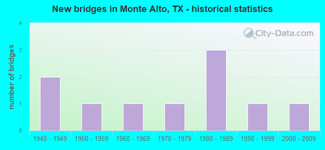
- New bridges - historical statistics
- 21940-1949
- 11950-1959
- 11960-1969
- 11970-1979
- 31980-1989
- 11990-1999
- 12000-2009

- Bridge Condition - Deck
- 40.0%Good
- 50.0%Satisfactory
- 10.0%Poor

- Bridge Condition - Superstructure
- 10.0%Very good
- 30.0%Good
- 50.0%Satisfactory
- 10.0%Fair

- Bridge Condition - Substructure
- 20.0%Good
- 50.0%Satisfactory
- 30.0%Poor

- Bridge Condition - Channel
- 20.0%Good
- 50.0%Satisfactory
- 30.0%Fair
Find on map >> Show street view
Structure Number: 211090069802005, Location: 2.60 MI N OF FM 1422 (Lat: 26.420331, Lng: -97.956303), Route carried "on" structure: State highway 88, Year Built: 1971, Status: Open, Structure Length: 3.81m (12.50ft), Average Daily Traffic: 922 (year 2020), Truck Traffic: 16%, Average Future Daily Traffic: 1,610 (year 2033), Design Load: HS 20, Features Intersected: DELTA LAKE DRAIN
Minimum Vertical Clearance: 30+ m (98+ ft), Kilometerpoint: 2.409, Lanes on structure: 2, Owner: State Highway Agency, Approaching Roadway Width: 12.8m (42.0ft), Skew: 2 degrees, Material/Design: Concrete, Design/Construction: Stringer/Multi-beam, Number Of Spans In Main Unit: 3, Length of Maximum Span: 12.8m (42.0ft), Curb-To-Curb Width: 14.6m (47.9ft), Out-to-Out Width: 15.3m (50.2ft)
Condition: Deck: Good, Superstructure: Good, Substructure: Good, Channel: Good, Operating Rating: 68.0 metric tons, Method Used To Determine Operating Rating: Load Factor (LF), Inventory Rating: 40.8 metric tons, Method Used To Determine Inventory Rating: Load Factor (LF), Structural Evaluation: Better than present minimum criteria, Deck Geometry: Superior to present desirable criteria, Waterway Adequacy: Superior to present desirable criteria, Approach Roadway Alignment: Equal to present desirable criteria, Designated Inspection Frequency: Every 24 months, Inspection Date: May 2021, Deck Structure Type: Concrete Cast-file-Place, Wearing Surface/Protective System: Wearing Surface: Bituminous
Find on map >> Show street view
Structure Number: 211090122802015, Location: 0.60 MI N OF FM 1422 (Lat: 26.388789, Lng: -97.933389), Route carried "on" structure: State highway 1015, Year Built: 1998, Status: Open, Structure Length: 4.94m (16.21ft), Average Daily Traffic: 920 (year 2020), Truck Traffic: 6%, Average Future Daily Traffic: 810 (year 2031), Design Load: HS 20, Features Intersected: WILLACY MAIN CANAL
Minimum Vertical Clearance: 30+ m (98+ ft), Kilometerpoint: 5.430, Lanes on structure: 2, Owner: State Highway Agency, Approaching Roadway Width: 12.2m (40.0ft), Material/Design: Prestressed concrete, Design/Construction: Box Beam or Girders - Multiple, Number Of Spans In Main Unit: 3, Length of Maximum Span: 16.5m (54.1ft), Curb-To-Curb Width: 12.1m (39.7ft), Out-to-Out Width: 12.6m (41.3ft)
Condition: Deck: Good, Superstructure: Very good, Substructure: Satisfactory, Channel: Satisfactory, Operating Rating: 54.4 metric tons, Method Used To Determine Operating Rating: Assigned rating based on Load Factor Design (LFD) reported in metric tons, Inventory Rating: 32.7 metric tons, Method Used To Determine Inventory Rating: Assigned rating based on Load Factor Design (LFD) reported in metric tons, Structural Evaluation: Equal to present minimum criteria, Deck Geometry: Better than present minimum criteria, Waterway Adequacy: Equal to present minimum criteria, Approach Roadway Alignment: Equal to present desirable criteria, Designated Inspection Frequency: Every 24 months, Underwater Inspection Frequency: Every 60 months, Inspection Date: May 2021, Underwater Inspection Date: September 2019, Deck Structure Type: Concrete Cast-file-Place
Find on map >> Show street view
Structure Number: 211090123602004, Location: 0.75 MI E OF FM 1015 (Lat: 26.378033, Lng: -97.922708), Route carried "on" structure: State highway 1422, Year Built: 2007, Status: Open, Structure Length: 4.97m (16.31ft), Average Daily Traffic: 358 (year 2020), Truck Traffic: 6%, Average Future Daily Traffic: 530 (year 2033), Design Load: HL 93, Features Intersected: WILLACY MAIN CANAL
Minimum Vertical Clearance: 30+ m (98+ ft), Kilometerpoint: 17.333, Lanes on structure: 2, Owner: State Highway Agency, Approaching Roadway Width: 8.5m (27.9ft), Skew: 1 degrees, Material/Design: Concrete, Design/Construction: Stringer/Multi-beam, Number Of Spans In Main Unit: 4, Length of Maximum Span: 12.5m (41.0ft), Curb-To-Curb Width: 13.4m (44.0ft), Out-to-Out Width: 14.0m (45.9ft)
Condition: Deck: Satisfactory, Superstructure: Satisfactory, Substructure: Good, Channel: Good, Operating Rating: 54.4 metric tons, Method Used To Determine Operating Rating: Assigned ratings based on Load and Resistance Factor Design (LRFD) reported in metric tons, Inventory Rating: 32.7 metric tons, Method Used To Determine Inventory Rating: Assigned ratings based on Load and Resistance Factor Design (LRFD) reported in metric tons, Structural Evaluation: Equal to present minimum criteria, Deck Geometry: Superior to present desirable criteria, Waterway Adequacy: Superior to present desirable criteria, Approach Roadway Alignment: Equal to present desirable criteria, Designated Inspection Frequency: Every 24 months, Underwater Inspection Frequency: Every 60 months, Inspection Date: May 2021, Underwater Inspection Date: January 2017, Deck Structure Type: Concrete Cast-file-Place
Find on map >> Show street view
Structure Number: 211090AA0300001, Location: 0.15 MI W OF FM 1015 (Lat: 26.337297, Lng: -97.945106), Route carried "on" structure: County highway , Year Built: 1980, Status: Open, Structure Length: 4.69m (15.39ft), Average Daily Traffic: 100 (year 2019), Average Future Daily Traffic: 100 (year 2030), Features Intersected: MAIN FLOODWATER CHANNEL, Facility Carried by Structure: Mile 20 N Rd
Minimum Vertical Clearance: 30+ m (98+ ft), Kilometerpoint: 1.368, Lanes on structure: 2, Owner: County Highway Agency, Approaching Roadway Width: 4.9m (16.1ft), Material/Design: Concrete, Design/Construction: Stringer/Multi-beam, Number Of Spans In Main Unit: 5, Length of Maximum Span: 9.1m (29.9ft), Curb-To-Curb Width: 7.9m (25.9ft), Out-to-Out Width: 8.6m (28.2ft)
Condition: Deck: Good, Superstructure: Good, Substructure: Satisfactory, Channel: Satisfactory, Operating Rating: 32.7 metric tons, Method Used To Determine Operating Rating: Field evaluation and documented engineering judgment, Inventory Rating: 24.5 metric tons, Method Used To Determine Inventory Rating: Field evaluation and documented engineering judgment, Structural Evaluation: Equal to present minimum criteria, Deck Geometry: Equal to present minimum criteria, Waterway Adequacy: Better than present minimum criteria, Approach Roadway Alignment: Equal to present desirable criteria, Designated Inspection Frequency: Every 24 months, Inspection Date: June 2020, Deck Structure Type: Concrete Cast-file-Place
Find on map >> Show street view
Structure Number: 211090AA0305001, Location: 1.40 MI N OF FM 1925 (Lat: 26.334633, Lng: -97.975814), Route carried "on" structure: County highway , Year Built: 1984, Status: Open, Structure Length: 4.69m (15.39ft), Average Daily Traffic: 100 (year 2019), Average Future Daily Traffic: 110 (year 2030), Features Intersected: MAIN FLOODWATER CHANNEL, Facility Carried by Structure: MILE 4 W RD
Minimum Vertical Clearance: 30+ m (98+ ft), Kilometerpoint: 2.253, Lanes on structure: 2, Owner: County Highway Agency, Approaching Roadway Width: 3.7m (12.1ft), Material/Design: Concrete, Design/Construction: Stringer/Multi-beam, Number Of Spans In Main Unit: 5, Length of Maximum Span: 9.1m (29.9ft), Curb-To-Curb Width: 7.9m (25.9ft), Out-to-Out Width: 8.6m (28.2ft)
Condition: Deck: Satisfactory, Superstructure: Satisfactory, Substructure: Satisfactory, Channel: Satisfactory, Operating Rating: 32.7 metric tons, Method Used To Determine Operating Rating: Field evaluation and documented engineering judgment, Inventory Rating: 24.5 metric tons, Method Used To Determine Inventory Rating: Field evaluation and documented engineering judgment, Structural Evaluation: Equal to present minimum criteria, Deck Geometry: Equal to present minimum criteria, Waterway Adequacy: Better than present minimum criteria, Approach Roadway Alignment: Equal to present desirable criteria, Designated Inspection Frequency: Every 24 months, Inspection Date: June 2020, Deck Structure Type: Concrete Cast-file-Place
Find on map >> Show street view
Structure Number: 211090AA0307001, Location: 2.70 MI S OF FM 1422 (Lat: 26.343078, Lng: -97.957944), Route carried "on" structure: County highway , Year Built: 1983, Status: Open, Structure Length: 4.69m (15.39ft), Average Daily Traffic: 80 (year 2010), Average Future Daily Traffic: 110 (year 2030), Features Intersected: MAIN FLOODWATER CHANNEL, Facility Carried by Structure: MILE 3 W RD
Minimum Vertical Clearance: 30+ m (98+ ft), Kilometerpoint: 4.345, Lanes on structure: 2, Owner: County Highway Agency, Approaching Roadway Width: 3.7m (12.1ft), Material/Design: Concrete, Design/Construction: Stringer/Multi-beam, Number Of Spans In Main Unit: 5, Length of Maximum Span: 9.1m (29.9ft), Curb-To-Curb Width: 7.8m (25.6ft), Out-to-Out Width: 8.6m (28.2ft)
Condition: Deck: Good, Superstructure: Good, Substructure: Satisfactory, Channel: Satisfactory, Operating Rating: 32.7 metric tons, Method Used To Determine Operating Rating: Field evaluation and documented engineering judgment, Inventory Rating: 24.5 metric tons, Method Used To Determine Inventory Rating: Field evaluation and documented engineering judgment, Structural Evaluation: Equal to present minimum criteria, Deck Geometry: Equal to present minimum criteria, Waterway Adequacy: Better than present minimum criteria, Approach Roadway Alignment: Equal to present desirable criteria, Designated Inspection Frequency: Every 24 months, Inspection Date: June 2020, Deck Structure Type: Concrete Cast-file-Place
Find on map >> Show street view
Structure Number: 211090AA0341002, Location: 0.90 MI S OF FM 88 (Lat: 26.405572, Lng: -97.962867), Route carried "on" structure: County highway , Year Built: 1960, Status: Open, Structure Length: 2.83m (9.28ft), Average Daily Traffic: 960 (year 2010), Average Future Daily Traffic: 1,030 (year 2030), Features Intersected: DELTA LAKE IRRIG CANAL, Facility Carried by Structure: DELTA LAKE PARK RD
Minimum Vertical Clearance: 30+ m (98+ ft), Kilometerpoint: 0.483, Lanes on structure: 2, Owner: County Highway Agency, Approaching Roadway Width: 4.9m (16.1ft), Material/Design: Concrete, Design/Construction: Stringer/Multi-beam, Number Of Spans In Main Unit: 3, Length of Maximum Span: 9.1m (29.9ft), Curb-To-Curb Width: 6.0m (19.7ft), Out-to-Out Width: 6.6m (21.7ft)
Condition: Deck: Satisfactory, Superstructure: Satisfactory, Substructure: Satisfactory, Channel: Fair, Operating Rating: 32.7 metric tons, Method Used To Determine Operating Rating: Field evaluation and documented engineering judgment, Inventory Rating: 24.5 metric tons, Method Used To Determine Inventory Rating: Field evaluation and documented engineering judgment, Structural Evaluation: Equal to present minimum criteria, Deck Geometry: High priority of replacement, Waterway Adequacy: Better than present minimum criteria, Approach Roadway Alignment: Somewhat better than minimum adequacy, Length Of Structure Improvement: 2.83m (9.28ft), Designated Inspection Frequency: Every 24 months, Underwater Inspection Frequency: Every 60 months, Inspection Date: May 2020, Underwater Inspection Date: Febuary 2019, Bridge Improvement Cost: $4,000, Roadway Improvement Cost: $1,000, Total Project Cost: $5,000, Deck Structure Type: Concrete Cast-file-Place
Find on map >> Show street view
Structure Number: 211090AA0341004, Location: 1.25 MI W OF JCT FM 88 (Lat: 26.401856, Lng: -97.984242), Route carried "on" structure: County highway , Year Built: 1945, Status: Posted for load, Structure Length: 1.40m (4.59ft), Average Daily Traffic: 250 (year 2010), Truck Traffic: 5%, Average Future Daily Traffic: 310 (year 2030), Features Intersected: DRAINAGE DITCH, Facility Carried by Structure: NITTLER ROAD
Minimum Vertical Clearance: 30+ m (98+ ft), Kilometerpoint: 2.012, Lanes on structure: 2, Owner: County Highway Agency, Approaching Roadway Width: 5.5m (18.0ft), Skew: 3 degrees, Material/Design: Concrete, Design/Construction: Slab, Number Of Spans In Main Unit: 3, Length of Maximum Span: 4.6m (15.1ft), Curb-To-Curb Width: 6.7m (22.0ft), Out-to-Out Width: 7.3m (24.0ft)
Condition: Deck: Satisfactory, Superstructure: Satisfactory, Substructure: Poor, Channel: Fair, Operating Rating: 32.7 metric tons, Method Used To Determine Operating Rating: Field evaluation and documented engineering judgment, Inventory Rating: 24.5 metric tons, Method Used To Determine Inventory Rating: Field evaluation and documented engineering judgment, Structural Evaluation: Meets minimum limits, Deck Geometry: Meets minimum limits, Waterway Adequacy: Better than present minimum criteria, Approach Roadway Alignment: Equal to present desirable criteria, Bridge Posting: Required (Relationship of Operating Rating to Maximum Legal Load: 20.0 - 29.9% below), Designated Inspection Frequency: Every 24 months, Inspection Date: May 2020, Deck Structure Type: Concrete Cast-file-Place
Find on map >> Show street view
Structure Number: 211090AA0341005, Location: 0.20 MI W OF JCT FM 88 (Lat: 26.399383, Lng: -97.967292), Route carried "on" structure: County highway , Year Built: 1945, Status: Posted for load, Structure Length: 1.40m (4.59ft), Average Daily Traffic: 280 (year 2010), Truck Traffic: 2%, Average Future Daily Traffic: 350 (year 2030), Features Intersected: DRAINAGE DITCH, Facility Carried by Structure: NITTLER ROAD
Minimum Vertical Clearance: 30+ m (98+ ft), Kilometerpoint: 8.047, Lanes on structure: 2, Owner: County Highway Agency, Approaching Roadway Width: 5.5m (18.0ft), Material/Design: Concrete, Design/Construction: Slab, Number Of Spans In Main Unit: 3, Length of Maximum Span: 4.6m (15.1ft), Curb-To-Curb Width: 6.7m (22.0ft), Out-to-Out Width: 7.4m (24.3ft)
Condition: Deck: Satisfactory, Superstructure: Satisfactory, Substructure: Poor, Channel: Fair, Operating Rating: 29.0 metric tons, Method Used To Determine Operating Rating: Allowable Stress (AS), Inventory Rating: 20.0 metric tons, Method Used To Determine Inventory Rating: Allowable Stress (AS), Structural Evaluation: Meets minimum limits, Deck Geometry: Meets minimum limits, Waterway Adequacy: Better than present minimum criteria, Approach Roadway Alignment: Equal to present desirable criteria, Bridge Posting: Required (Relationship of Operating Rating to Maximum Legal Load: 10.0 - 19.9% below), Designated Inspection Frequency: Every 24 months, Inspection Date: May 2020, Deck Structure Type: Concrete Cast-file-Place
Find on map >> Show street view
Structure Number: 211090AA0342001, Location: 1.35 MI W OF FM 88 (Lat: 26.408456, Lng: -97.986217), Route carried "on" structure: County highway , Year Built: 1950, Status: Closed, Structure Length: 0.82m (2.69ft), Average Daily Traffic: 330 (year 2010), Average Future Daily Traffic: 350 (year 2030), Features Intersected: DELTA LAKE IRRIG CANAL, Facility Carried by Structure: CHARLES GREEN ROAD
Minimum Vertical Clearance: 30+ m (98+ ft), Kilometerpoint: 2.173, Lanes on structure: 1, Owner: County Highway Agency, Approaching Roadway Width: 3.0m (9.8ft), Material/Design: Wood or Timber, Design/Construction: Stringer/Multi-beam, Number Of Spans In Main Unit: 2, Length of Maximum Span: 3.7m (12.1ft), Curb-To-Curb Width: 5.5m (18.0ft), Out-to-Out Width: 5.5m (18.0ft)
Condition: Deck: Poor, Superstructure: Fair, Substructure: Poor, Channel: Satisfactory, Deck Geometry: High priority of corrective action, Waterway Adequacy: Better than present minimum criteria, Approach Roadway Alignment: High priority of corrective action, Bridge Posting: Required (Relationship of Operating Rating to Maximum Legal Load: > 39.9% below), Length Of Structure Improvement: 1.52m (4.99ft), Designated Inspection Frequency: Every 24 months, Inspection Date: June 2020, Bridge Improvement Cost: $3,000, Roadway Improvement Cost: $1,000, Total Project Cost: $4,000, Deck Structure Type: Concrete Cast-file-Place