Bridge Statistics for Monte Vista, Colorado (CO)
Condition, Traffic, Stress, Structural Evaluation, Project Costs
- National Bridge Inventory (NBI) Statistics
- 11Number of bridges
- 95ft / 29.1mTotal length
- 12,878Total average daily traffic
- 795Total average daily truck traffic
- 15,059Total future (year 2037) average daily traffic
- National Bridge Inventory (NBI) Registered Bridges for Monte Vista
- No street view available for this location
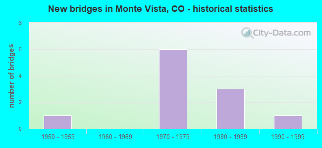
- New bridges - historical statistics
- 11950-1959
- 61970-1979
- 31980-1989
- 11990-1999

- Reconstructed bridges - Historical Statistics
- 11960-1969
- 01970-1979
- 01980-1989
- 11990-1999


- Bridge Condition - Deck
- 50.0%Good
- 50.0%Satisfactory

- Bridge Condition - Superstructure
- 50.0%Good
- 50.0%Satisfactory

- Bridge Condition - Substructure
- 20.0%Good
- 70.0%Satisfactory
- 10.0%Fair

- Bridge Condition - Channel
- 18.2%Very good
- 72.7%Good
- 9.1%Fair
Find on map >> Show street view
Structure Number: N-12-AX, Location: N.EDGE OF MONTE VISTA (Lat: 37.609003, Lng: -106.149211), Route carried "on" structure: US 285B, Year Built: 1971, Status: Open, Structure Length: 5.37m (17.62ft), Average Daily Traffic: 4,500 (year 2020), Truck Traffic: 6%, Average Future Daily Traffic: 4,725 (year 2040), Design Load: HS 20, Features Intersected: RIO GRANDE, Facility Carried by Structure: US 285 ML
Minimum Vertical Clearance: 30+ m (98+ ft), Kilometerpoint: 3.162, Lanes on structure: 4, Base Highway Network: Yes, Owner: State Highway Agency, Approaching Roadway Width: 25.0m (82.0ft), Material/Design: Prestressed concrete, Design/Construction: Stringer/Multi-beam, Number Of Spans In Main Unit: 2, Length of Maximum Span: 26.0m (85.3ft), Curb-To-Curb Width: 26.2m (86.0ft), Out-to-Out Width: 27.0m (88.6ft)
Condition: Deck: Good, Superstructure: Good, Substructure: Good, Channel: Good, Operating Rating: 61.4 metric tons, Method Used To Determine Operating Rating: Load Factor (LF), Inventory Rating: 36.8 metric tons, Method Used To Determine Inventory Rating: Load Factor (LF), Structural Evaluation: Better than present minimum criteria, Deck Geometry: Superior to present desirable criteria, Waterway Adequacy: Equal to present desirable criteria, Approach Roadway Alignment: Equal to present desirable criteria, Designated Inspection Frequency: Every 24 months, Inspection Date: July 2021, Deck Structure Type: Concrete Cast-file-Place, Wearing Surface/Protective System: Wearing Surface: Bituminous, Membrane: Built-up
Find on map >> Show street view
Structure Number: N-12-F, Location: 11.4 MI E OF JCT SH 112 (Lat: 37.585897, Lng: -106.197189), Route carried "on" structure: US 160A, Year Built: 1970, Status: Open, Structure Length: 3.75m (12.30ft), Average Daily Traffic: 4,600 (year 2020), Truck Traffic: 8%, Average Future Daily Traffic: 4,968 (year 2040), Design Load: HS 20, Features Intersected: MONTE VISTA CANAL, Facility Carried by Structure: US 160 ML
Minimum Vertical Clearance: 30+ m (98+ ft), Kilometerpoint: 340.962, Lanes on structure: 4, Base Highway Network: Yes, Owner: State Highway Agency, Approaching Roadway Width: 18.3m (60.0ft), Material/Design: Concrete, Design/Construction: Culvert, Number Of Spans In Main Unit: 3, Length of Maximum Span: 11.9m (39.0ft), Curb-To-Curb Width: 18.3m (60.0ft), Out-to-Out Width: 19.1m (62.7ft)
Condition: Channel: Very good, Culverts: Satisfactory, Operating Rating: 36.3 metric tons, Method Used To Determine Operating Rating: Field evaluation and documented engineering judgment, Inventory Rating: 32.7 metric tons, Method Used To Determine Inventory Rating: Field evaluation and documented engineering judgment, Structural Evaluation: Equal to present minimum criteria, Deck Geometry: Somewhat better than minimum adequacy, Waterway Adequacy: Superior to present desirable criteria, Approach Roadway Alignment: Equal to present desirable criteria, Designated Inspection Frequency: Every 24 months, Inspection Date: March 2021
Find on map >> Show street view
Structure Number: RGD000L-02.50W, Location: Just W of CR 28 (Lat: 37.574694, Lng: -106.194136), Route carried "on" structure: County highway , Year Built: 1971, Status: Open, Structure Length: 1.23m (4.04ft), Average Daily Traffic: 152 (year 2017), Truck Traffic: 2%, Average Future Daily Traffic: 216 (year 2037), Features Intersected: MONTE VISTA CANAL, Facility Carried by Structure: CR L / Lariat RD
Minimum Vertical Clearance: 30+ m (98+ ft), Kilometerpoint: 16.628, Lanes on structure: 2, Owner: County Highway Agency, Approaching Roadway Width: 8.5m (27.9ft), Skew: 1 degrees, Material/Design: Steel, Design/Construction: Stringer/Multi-beam, Number Of Spans In Main Unit: 1, Length of Maximum Span: 11.4m (37.4ft), Curb-To-Curb Width: 8.4m (27.6ft), Out-to-Out Width: 8.6m (28.2ft)
Condition: Deck: Satisfactory, Superstructure: Satisfactory, Substructure: Satisfactory, Channel: Good, Operating Rating: 32.6 metric tons, Method Used To Determine Operating Rating: Load Factor (LF), Inventory Rating: 19.5 metric tons, Method Used To Determine Inventory Rating: Load Factor (LF), Structural Evaluation: Somewhat better than minimum adequacy, Deck Geometry: Somewhat better than minimum adequacy, Waterway Adequacy: Equal to present desirable criteria, Approach Roadway Alignment: Better than present minimum criteria, Designated Inspection Frequency: Every 24 months, Inspection Date: December 2020, Deck Structure Type: Corrugated Steel, Wearing Surface/Protective System: Wearing Surface: Bituminous
Find on map >> Show street view
Structure Number: RGD027-02.40A, Location: 4.9 MI NW OF MONTE VISTA (Lat: 37.616933, Lng: -106.222281), Route carried "on" structure: County highway , Year Built: 1988, Status: Open, Structure Length: 3.04m (9.97ft), Average Daily Traffic: 122 (year 2017), Truck Traffic: 2%, Average Future Daily Traffic: 173 (year 2037), Design Load: HS 20+Mod, Features Intersected: RIO GRANDE CANAL, Facility Carried by Structure: COUNTY ROAD 27
Minimum Vertical Clearance: 30+ m (98+ ft), Kilometerpoint: 3.895, Lanes on structure: 2, Owner: County Highway Agency, Approaching Roadway Width: 8.8m (28.9ft), Skew: 6 degrees, Material/Design: Steel, Design/Construction: Stringer/Multi-beam, Number Of Spans In Main Unit: 1, Length of Maximum Span: 25.3m (83.0ft), Curb-To-Curb Width: 9.5m (31.2ft), Out-to-Out Width: 9.8m (32.2ft)
Condition: Deck: Satisfactory, Superstructure: Good, Substructure: Satisfactory, Channel: Very good, Operating Rating: 50.1 metric tons, Method Used To Determine Operating Rating: Load Factor (LF), Inventory Rating: 30.0 metric tons, Method Used To Determine Inventory Rating: Load Factor (LF), Structural Evaluation: Equal to present minimum criteria, Deck Geometry: Equal to present minimum criteria, Waterway Adequacy: Equal to present desirable criteria, Approach Roadway Alignment: Equal to present desirable criteria, Designated Inspection Frequency: Every 48 months, Inspection Date: December 2018, Deck Structure Type: Corrugated Steel, Wearing Surface/Protective System: Wearing Surface: Bituminous
Find on map >> Show street view
Structure Number: RGD029-02.00W, Location: .8 MI W OF SH15 GUNBARREL (Lat: 37.520414, Lng: -106.162564), Route carried "on" structure: County highway , Year Built: 1971, Status: Open, Structure Length: 1.37m (4.49ft), Average Daily Traffic: 35 (year 2017), Average Future Daily Traffic: 49 (year 2037), Features Intersected: MONTE VISTA CANAL, Facility Carried by Structure: COUNTY ROAD 29
Minimum Vertical Clearance: 30+ m (98+ ft), Kilometerpoint: 5.699, Lanes on structure: 2, Owner: County Highway Agency, Approaching Roadway Width: 7.9m (25.9ft), Skew: 3 degrees, Material/Design: Steel, Design/Construction: Stringer/Multi-beam, Number Of Spans In Main Unit: 1, Length of Maximum Span: 12.6m (41.3ft), Curb-To-Curb Width: 7.3m (24.0ft), Out-to-Out Width: 7.3m (24.0ft)
Condition: Deck: Good, Superstructure: Satisfactory, Substructure: Fair, Channel: Good, Operating Rating: 33.2 metric tons, Method Used To Determine Operating Rating: Load Factor (LF), Inventory Rating: 19.9 metric tons, Method Used To Determine Inventory Rating: Load Factor (LF), Structural Evaluation: Somewhat better than minimum adequacy, Deck Geometry: Equal to present minimum criteria, Waterway Adequacy: Better than present minimum criteria, Approach Roadway Alignment: Equal to present desirable criteria, Designated Inspection Frequency: Every 24 months, Inspection Date: December 2020, Deck Structure Type: Corrugated Steel, Wearing Surface/Protective System: Wearing Surface: Bituminous
Find on map >> Show street view
Structure Number: RGDE03-00.20NA, Location: 1.1 MI N OF SH 160 (Lat: 37.576061, Lng: -106.094117), Route carried "on" structure: County highway , Year Built: 1994, Status: Open, Structure Length: 1.52m (4.99ft), Average Daily Traffic: 1,370 (year 2017), Truck Traffic: 5%, Average Future Daily Traffic: 1,946 (year 2037), Design Load: HS 20, Features Intersected: EMPIRE CANAL, Facility Carried by Structure: COUNTY ROAD 3E
Minimum Vertical Clearance: 30+ m (98+ ft), Kilometerpoint: 1.914, Lanes on structure: 2, Owner: County Highway Agency, Approaching Roadway Width: 9.9m (32.5ft), Skew: 1 degrees, Material/Design: Steel, Design/Construction: Stringer/Multi-beam, Number Of Spans In Main Unit: 1, Length of Maximum Span: 14.3m (46.9ft), Curb-To-Curb Width: 9.1m (29.9ft), Out-to-Out Width: 9.9m (32.5ft)
Condition: Deck: Good, Superstructure: Good, Substructure: Good, Channel: Good, Operating Rating: 72.1 metric tons, Method Used To Determine Operating Rating: Load Factor (LF), Inventory Rating: 43.2 metric tons, Method Used To Determine Inventory Rating: Load Factor (LF), Structural Evaluation: Better than present minimum criteria, Deck Geometry: Somewhat better than minimum adequacy, Waterway Adequacy: Equal to present desirable criteria, Approach Roadway Alignment: Equal to present minimum criteria, Designated Inspection Frequency: Every 24 months, Inspection Date: December 2020, Deck Structure Type: Concrete Cast-file-Place, Wearing Surface/Protective System: Wearing Surface: Bituminous, Deck Protection: Epoxy Coated Reinforcing
Find on map >> Show street view
Structure Number: RGDE03-00.60N, Location: 1.5 MI N OF CR 1S (Lat: 37.582681, Lng: -106.094097), Route carried "on" structure: County highway , Year Built: 1970, Year Reconstructed: 1996, Status: Open, Structure Length: 4.58m (15.03ft), Average Daily Traffic: 1,478 (year 2017), Truck Traffic: 5%, Average Future Daily Traffic: 2,099 (year 2037), Features Intersected: RIO GRANDE RIVER, Facility Carried by Structure: COUNTY ROAD 3E
Minimum Vertical Clearance: 30+ m (98+ ft), Kilometerpoint: 2.689, Lanes on structure: 2, Owner: County Highway Agency, Approaching Roadway Width: 9.4m (30.8ft), Material/Design: Steel, Design/Construction: Stringer/Multi-beam, Number Of Spans In Main Unit: 3, Length of Maximum Span: 15.1m (49.5ft), Curb-To-Curb Width: 9.1m (29.9ft), Out-to-Out Width: 9.9m (32.5ft)
Condition: Deck: Good, Superstructure: Good, Substructure: Satisfactory, Channel: Good, Operating Rating: 40.0 metric tons, Method Used To Determine Operating Rating: Load Factor (LF), Inventory Rating: 23.9 metric tons, Method Used To Determine Inventory Rating: Load Factor (LF), Structural Evaluation: Equal to present minimum criteria, Deck Geometry: Somewhat better than minimum adequacy, Waterway Adequacy: Equal to present desirable criteria, Approach Roadway Alignment: Equal to present desirable criteria, Designated Inspection Frequency: Every 24 months, Inspection Date: December 2020, Deck Structure Type: Concrete Cast-file-Place, Wearing Surface/Protective System: Wearing Surface: Bituminous, Deck Protection: Epoxy Coated Reinforcing
Find on map >> Show street view
Structure Number: RGDS01-02.50W, Location: Just E of CR 28 (Lat: 37.560397, Lng: -106.197167), Route carried "on" structure: County highway , Year Built: 1981, Status: Open, Structure Length: 1.23m (4.04ft), Average Daily Traffic: 21 (year 2017), Average Future Daily Traffic: 30 (year 2037), Features Intersected: MONTE VISTA CANAL, Facility Carried by Structure: COUNTY ROAD 1S
Minimum Vertical Clearance: 30+ m (98+ ft), Kilometerpoint: 0.016, Lanes on structure: 2, Owner: County Highway Agency, Approaching Roadway Width: 8.8m (28.9ft), Skew: 1 degrees, Material/Design: Steel, Design/Construction: Stringer/Multi-beam, Number Of Spans In Main Unit: 1, Length of Maximum Span: 11.4m (37.4ft), Curb-To-Curb Width: 9.8m (32.2ft), Out-to-Out Width: 9.8m (32.2ft)
Condition: Deck: Satisfactory, Superstructure: Satisfactory, Substructure: Satisfactory, Channel: Good, Operating Rating: 32.7 metric tons, Method Used To Determine Operating Rating: Load Factor (LF), Inventory Rating: 19.6 metric tons, Method Used To Determine Inventory Rating: Load Factor (LF), Structural Evaluation: Somewhat better than minimum adequacy, Deck Geometry: Equal to present desirable criteria, Waterway Adequacy: Better than present minimum criteria, Approach Roadway Alignment: High priority of corrective action, Designated Inspection Frequency: Every 24 months, Inspection Date: December 2020, Deck Structure Type: Corrugated Steel, Wearing Surface/Protective System: Wearing Surface: Bituminous
Find on map >> Show street view
Structure Number: RGDS02-01.70W, Location: 0.5 MI E OF CR 28 (Lat: 37.545900, Lng: -106.180253), Route carried "on" structure: County highway , Year Built: 1950, Year Reconstructed: 1966, Status: Open, Structure Length: 1.46m (4.79ft), Average Daily Traffic: 158 (year 2018), Truck Traffic: 2%, Average Future Daily Traffic: 225 (year 2038), Features Intersected: MONTE VISTA CANAL, Facility Carried by Structure: COUNTY ROAD 2S
Minimum Vertical Clearance: 30+ m (98+ ft), Kilometerpoint: 1.271, Lanes on structure: 2, Owner: County Highway Agency, Approaching Roadway Width: 6.7m (22.0ft), Material/Design: Steel continuous, Design/Construction: Stringer/Multi-beam, Number Of Spans In Main Unit: 3, Length of Maximum Span: 4.6m (15.1ft), Curb-To-Curb Width: 7.3m (24.0ft), Out-to-Out Width: 7.3m (24.0ft)
Condition: Deck: Satisfactory, Superstructure: Good, Substructure: Satisfactory, Channel: Fair, Operating Rating: 36.7 metric tons, Method Used To Determine Operating Rating: Load Factor (LF), Inventory Rating: 22.0 metric tons, Method Used To Determine Inventory Rating: Load Factor (LF), Structural Evaluation: Equal to present minimum criteria, Deck Geometry: Somewhat better than minimum adequacy, Waterway Adequacy: Equal to present minimum criteria, Approach Roadway Alignment: Equal to present desirable criteria, Designated Inspection Frequency: Every 24 months, Inspection Date: December 2020, Deck Structure Type: Corrugated Steel, Wearing Surface/Protective System: Wearing Surface: Bituminous
Find on map >> Show street view
Structure Number: RGDW03-02.70N, Location: .4 MI N of Swede Lane (Lat: 37.615397, Lng: -106.204256), Route carried "on" structure: County highway , Year Built: 1978, Status: Open, Structure Length: 1.23m (4.04ft), Average Daily Traffic: 224 (year 2017), Truck Traffic: 2%, Average Future Daily Traffic: 318 (year 2037), Features Intersected: CONSOLIDATED CANAL, Facility Carried by Structure: COUNTY ROAD 3W
Minimum Vertical Clearance: 30+ m (98+ ft), Kilometerpoint: 2.013, Lanes on structure: 2, Owner: County Highway Agency, Approaching Roadway Width: 7.9m (25.9ft), Material/Design: Steel, Design/Construction: Stringer/Multi-beam, Number Of Spans In Main Unit: 1, Length of Maximum Span: 11.7m (38.4ft), Curb-To-Curb Width: 9.8m (32.2ft), Out-to-Out Width: 9.8m (32.2ft)
Condition: Deck: Satisfactory, Superstructure: Satisfactory, Substructure: Satisfactory, Channel: Good, Operating Rating: 42.2 metric tons, Method Used To Determine Operating Rating: Load Factor (LF), Inventory Rating: 25.3 metric tons, Method Used To Determine Inventory Rating: Load Factor (LF), Structural Evaluation: Equal to present minimum criteria, Deck Geometry: Better than present minimum criteria, Waterway Adequacy: Equal to present desirable criteria, Approach Roadway Alignment: Equal to present desirable criteria, Designated Inspection Frequency: Every 24 months, Inspection Date: December 2020, Deck Structure Type: Corrugated Steel, Wearing Surface/Protective System: Wearing Surface: Bituminous
Find on map >> Show street view
Structure Number: RGDW03-03.60N, Location: .5 MI S OF CR 4N (Lat: 37.624194, Lng: -106.204231), Route carried "on" structure: County highway , Year Built: 1980, Status: Open, Structure Length: 4.31m (14.14ft), Average Daily Traffic: 218 (year 2017), Truck Traffic: 2%, Average Future Daily Traffic: 310 (year 2037), Features Intersected: RIO GRANDE RIVER, Facility Carried by Structure: COUNTY ROAD 3W
Minimum Vertical Clearance: 30+ m (98+ ft), Kilometerpoint: 2.992, Lanes on structure: 2, Owner: County Highway Agency, Approaching Roadway Width: 7.9m (25.9ft), Skew: 2 degrees, Material/Design: Steel, Design/Construction: Stringer/Multi-beam, Number Of Spans In Main Unit: 2, Length of Maximum Span: 20.9m (68.6ft), Curb-To-Curb Width: 9.5m (31.2ft), Out-to-Out Width: 9.8m (32.2ft)
Condition: Deck: Good, Superstructure: Satisfactory, Substructure: Satisfactory, Channel: Good, Operating Rating: 46.9 metric tons, Method Used To Determine Operating Rating: Load Factor (LF), Inventory Rating: 28.1 metric tons, Method Used To Determine Inventory Rating: Load Factor (LF), Structural Evaluation: Equal to present minimum criteria, Deck Geometry: Equal to present minimum criteria, Waterway Adequacy: Equal to present desirable criteria, Approach Roadway Alignment: Equal to present desirable criteria, Designated Inspection Frequency: Every 24 months, Inspection Date: December 2020, Deck Structure Type: Corrugated Steel, Wearing Surface/Protective System: Wearing Surface: Bituminous