Bridge Statistics for Montesano, Washington (WA)
Condition, Traffic, Stress, Structural Evaluation, Project Costs
- National Bridge Inventory (NBI) Statistics
- 29Number of bridges
- 971ft / 296mTotal length
- $140,991,000Total costs
- 137,702Total average daily traffic
- 10,270Total average daily truck traffic
- National Bridge Inventory (NBI) Registered Bridges for Montesano
- No street view available for this location
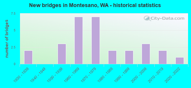
- New bridges - historical statistics
- 21930-1939
- 31950-1959
- 71960-1969
- 71970-1979
- 21980-1989
- 21990-1999
- 32000-2009
- 22010-2019
- 12020-2022


- Bridge Condition - Deck
- 4.5%Very good
- 68.2%Good
- 22.7%Satisfactory
- 4.5%Poor

- Bridge Condition - Superstructure
- 4.5%Very good
- 54.5%Good
- 27.3%Satisfactory
- 9.1%Fair
- 4.5%Poor

- Bridge Condition - Substructure
- 13.6%Very good
- 50.0%Good
- 4.5%Satisfactory
- 22.7%Fair
- 4.5%Poor
- 4.5%Serious

- Bridge Condition - Channel
- 36.0%Very good
- 40.0%Good
- 20.0%Satisfactory
- 4.0%Fair

- Bridge Condition - Culverts
- 50.0%Very good
- 25.0%Good
- 25.0%Satisfactory
Find on map >> Show street view
Structure Number: 1949A, Location: 8.3 E JCT US 101 (Lat: 46.976583, Lng: -123.643944), Route carried "on" structure: US 12, Year Built: 1935, Status: Open, Structure Length: 8.72m (28.61ft), Average Daily Traffic: 20,345 (year 2019), Truck Traffic: 7%, Average Future Daily Traffic: 23,274 (year 2039), Design Load: H 15, Features Intersected: WYNOOCHEE RIVER
Minimum Vertical Clearance: 4.95m (16.24ft), Kilometerpoint: 13.406, Lanes on structure: 4, Base Highway Network: Yes, Owner: State Highway Agency, Approaching Roadway Width: 18.3m (60.0ft), Material/Design: Steel, Design/Construction: Truss - Thru, Number Of Spans In Main Unit: 1, Number Of Approach Spans: 2, Length of Maximum Span: 61.0m (200.1ft), Curb-To-Curb Width: 13.4m (44.0ft), Out-to-Out Width: 13.9m (45.6ft)
Condition: Deck: Satisfactory, Superstructure: Poor, Substructure: Satisfactory, Channel: Satisfactory, Operating Rating: 47.2 metric tons, Method Used To Determine Operating Rating: Load Factor (LF), Inventory Rating: 28.1 metric tons, Method Used To Determine Inventory Rating: Load Factor (LF), Structural Evaluation: Meets minimum limits, Deck Geometry: High priority of replacement, Waterway Adequacy: Equal to present desirable criteria, Approach Roadway Alignment: Equal to present desirable criteria, Length Of Structure Improvement: 8.72m (28.61ft), Designated Inspection Frequency: Every 24 months, Critical Feature Inspection Frequency: Every 24 months, Inspection Date: June 2021, Critical Feature Inspection Date: June 2021, Bridge Improvement Cost: $3,546,000, Roadway Improvement Cost: $709,000, Total Project Cost: $7,093,000 ( Estimate for 2014), Deck Structure Type: Concrete Cast-file-Place, Wearing Surface/Protective System: Wearing Surface: Bituminous, Membrane: Preformed Fabric
Find on map >> Show street view
Structure Number: 4381A, Location: 7.6 N JCT US 101 (Lat: 46.970306, Lng: -123.601306), Route carried "on" structure: State highway 107, Year Built: 1953, Status: Open, Structure Length: 9.36m (30.71ft), Average Daily Traffic: 4,341 (year 2019), Truck Traffic: 11%, Average Future Daily Traffic: 4,966 (year 2039), Design Load: HS 15, Features Intersected: SLOUGH
Minimum Vertical Clearance: 30+ m (98+ ft), Kilometerpoint: 12.199, Lanes on structure: 2, Base Highway Network: Yes, Owner: State Highway Agency, Approaching Roadway Width: 9.4m (30.8ft), Material/Design: Wood or Timber, Design/Construction: Stringer/Multi-beam, Number Of Spans In Main Unit: 16, Length of Maximum Span: 5.8m (19.0ft), Curb or Sidewalk Widths: Left: 0.0m, Right: 1.1m (3.6ft), Curb-To-Curb Width: 6.8m (22.3ft), Out-to-Out Width: 8.4m (27.6ft)
Condition: Deck: Satisfactory, Superstructure: Satisfactory, Substructure: Fair, Channel: Good, Operating Rating: 39.0 metric tons, Method Used To Determine Operating Rating: Allowable Stress (AS), Inventory Rating: 27.2 metric tons, Method Used To Determine Inventory Rating: Allowable Stress (AS), Structural Evaluation: Somewhat better than minimum adequacy, Deck Geometry: High priority of replacement, Waterway Adequacy: Equal to present minimum criteria, Approach Roadway Alignment: Equal to present desirable criteria, Length Of Structure Improvement: 9.36m (30.71ft), Designated Inspection Frequency: Every 24 months, Inspection Date: June 2020, Bridge Improvement Cost: $2,026,000, Roadway Improvement Cost: $405,000, Total Project Cost: $4,052,000 ( Estimate for 2014), Deck Structure Type: Wood or Timber, Wearing Surface/Protective System: Wearing Surface: Bituminous
Find on map >> Show street view
Structure Number: 4381B, Location: 7.8 N JCT US 101 (Lat: 46.972972, Lng: -123.600972), Route carried "on" structure: State highway 107, Year Built: 1953, Status: Open, Structure Length: 8.50m (27.89ft), Average Daily Traffic: 4,341 (year 2019), Truck Traffic: 11%, Average Future Daily Traffic: 4,966 (year 2039), Design Load: HS 15, Features Intersected: SLOUGH
Minimum Vertical Clearance: 30+ m (98+ ft), Kilometerpoint: 12.521, Lanes on structure: 2, Base Highway Network: Yes, Owner: State Highway Agency, Approaching Roadway Width: 8.8m (28.9ft), Material/Design: Wood or Timber, Design/Construction: Stringer/Multi-beam, Number Of Spans In Main Unit: 15, Length of Maximum Span: 5.8m (19.0ft), Curb or Sidewalk Widths: Left: 0.0m, Right: 1.2m (3.9ft), Curb-To-Curb Width: 6.9m (22.6ft), Out-to-Out Width: 8.5m (27.9ft)
Condition: Deck: Good, Superstructure: Good, Substructure: Fair, Channel: Satisfactory, Operating Rating: 38.1 metric tons, Method Used To Determine Operating Rating: Allowable Stress (AS), Inventory Rating: 26.3 metric tons, Method Used To Determine Inventory Rating: Allowable Stress (AS), Structural Evaluation: Somewhat better than minimum adequacy, Deck Geometry: High priority of replacement, Waterway Adequacy: Equal to present desirable criteria, Approach Roadway Alignment: Equal to present desirable criteria, Length Of Structure Improvement: 8.50m (27.89ft), Designated Inspection Frequency: Every 24 months, Inspection Date: June 2020, Bridge Improvement Cost: $1,730,000, Roadway Improvement Cost: $346,000, Total Project Cost: $3,460,000 ( Estimate for 2014), Deck Structure Type: Wood or Timber, Wearing Surface/Protective System: Wearing Surface: Bituminous
Find on map >> Show street view
Structure Number: 5827A, Location: 6.9 N JCT US 101 (Lat: 46.959611, Lng: -123.603111), Route carried "on" structure: State highway 107, Year Built: 1958, Year Reconstructed: 2021, Status: Open, Structure Length: 39.93m (131.00ft), Average Daily Traffic: 4,002 (year 2019), Truck Traffic: 11%, Average Future Daily Traffic: 4,578 (year 2039), Design Load: HS 20, Features Intersected: CHEHALIS RIVER
Minimum Vertical Clearance: 4.65m (15.26ft), Kilometerpoint: 10.976, Lanes on structure: 2, Base Highway Network: Yes, Owner: State Highway Agency, Approaching Roadway Width: 9.1m (29.9ft), Navigation Control: Yes ( Vertical Clearance: 4.6m (15.1ft), Horizontal Clearance: 30.5m (100.1ft)), Material/Design: Steel, Design/Construction: Truss - Thru, Number Of Spans In Main Unit: 1, Number Of Approach Spans: 6, Length of Maximum Span: 91.4m (299.9ft), Curb-To-Curb Width: 9.1m (29.9ft), Out-to-Out Width: 9.8m (32.2ft)
Condition: Deck: Good, Superstructure: Good, Substructure: Very good, Channel: Fair, Operating Rating: 36.3 metric tons, Method Used To Determine Operating Rating: Load Factor (LF), Inventory Rating: 21.8 metric tons, Method Used To Determine Inventory Rating: Load Factor (LF), Structural Evaluation: Somewhat better than minimum adequacy, Deck Geometry: Meets minimum limits, Waterway Adequacy: Equal to present desirable criteria, Approach Roadway Alignment: Equal to present desirable criteria, Length Of Structure Improvement: 39.93m (131.00ft), Designated Inspection Frequency: Every 24 months, Critical Feature Inspection Frequency: Every 24 months, Inspection Date: June 2021, Critical Feature Inspection Date: June 2021, Bridge Improvement Cost: $8,384,000, Roadway Improvement Cost: $1,677,000, Total Project Cost: $16,768,000 ( Estimate for 2014), Deck Structure Type: Concrete Cast-file-Place
Find on map >> Show street view
Structure Number: 8172A, Location: 9.7 E JCT US 101 (Lat: 46.973667, Lng: -123.614889), Route carried "on" structure: US 12, Year Built: 1968, Status: Open, Structure Length: 33.71m (110.60ft), Average Daily Traffic: 10,656 (year 2019), Truck Traffic: 7%, Average Future Daily Traffic: 12,190 (year 2039), Design Load: HS 20+Mod, Features Intersected: SYLVIA CR NP RY
Minimum Vertical Clearance: 30+ m (98+ ft), Kilometerpoint: 15.530, Lanes on structure: 2, Base Highway Network: Yes, Owner: State Highway Agency, Approaching Roadway Width: 10.1m (33.1ft), Material/Design: Prestressed concrete, Design/Construction: Stringer/Multi-beam, Number Of Spans In Main Unit: 14, Length of Maximum Span: 26.2m (86.0ft), Curb or Sidewalk Widths: Left: 0.2m (0.7ft), Right: 0.2m (0.7ft), Curb-To-Curb Width: 10.1m (33.1ft), Out-to-Out Width: 11.1m (36.4ft)
Condition: Deck: Good, Superstructure: Satisfactory, Substructure: Good, Channel: Very good, Operating Rating: 32.4 metric tons, Method Used To Determine Operating Rating: Load and Resistance Factor Rating (LRFR) rating reported by rating factor(RF) method using HL-93 loadings, Inventory Rating: 19.8 metric tons, Method Used To Determine Inventory Rating: Load and Resistance Factor Rating (LRFR) rating reported by rating factor(RF) method using HL-93 loadings, Structural Evaluation: Somewhat better than minimum adequacy, Deck Geometry: Meets minimum limits, Underclear: Better than present minimum criteria, Waterway Adequacy: Equal to present desirable criteria, Approach Roadway Alignment: Equal to present desirable criteria, Length Of Structure Improvement: 33.71m (110.60ft), Designated Inspection Frequency: Every 24 months, Inspection Date: August 2021, Bridge Improvement Cost: $7,742,000, Roadway Improvement Cost: $1,548,000, Total Project Cost: $15,484,000 ( Estimate for 2014), Deck Structure Type: Concrete Cast-file-Place, Wearing Surface/Protective System: Wearing Surface: Latex Concrete
Find on map >> Show street view
Structure Number: 8172B, Location: 9.7 E JCT US 101 (Lat: 46.973322, Lng: -123.612453), Route carried "on" structure: US 12, Year Built: 1968, Status: Open, Structure Length: 33.35m (109.42ft), Average Daily Traffic: 10,656 (year 2019), Truck Traffic: 7%, Average Future Daily Traffic: 12,190 (year 2039), Design Load: HS 20+Mod, Features Intersected: SYLVIA CR NP RY
Minimum Vertical Clearance: 30+ m (98+ ft), Kilometerpoint: 15.530, Lanes on structure: 2, Base Highway Network: Yes, Owner: State Highway Agency, Approaching Roadway Width: 10.1m (33.1ft), Material/Design: Prestressed concrete, Design/Construction: Stringer/Multi-beam, Number Of Spans In Main Unit: 14, Length of Maximum Span: 26.2m (86.0ft), Curb or Sidewalk Widths: Left: 0.2m (0.7ft), Right: 0.2m (0.7ft), Curb-To-Curb Width: 10.1m (33.1ft), Out-to-Out Width: 11.1m (36.4ft)
Condition: Deck: Good, Superstructure: Satisfactory, Substructure: Good, Channel: Very good, Operating Rating: 23.0 metric tons, Method Used To Determine Operating Rating: Load and Resistance Factor Rating (LRFR) rating reported by rating factor(RF) method using HL-93 loadings, Inventory Rating: 17.5 metric tons, Method Used To Determine Inventory Rating: Load and Resistance Factor Rating (LRFR) rating reported by rating factor(RF) method using HL-93 loadings, Structural Evaluation: Meets minimum limits, Deck Geometry: Somewhat better than minimum adequacy, Underclear: Better than present minimum criteria, Waterway Adequacy: Equal to present desirable criteria, Approach Roadway Alignment: Equal to present desirable criteria, Length Of Structure Improvement: 33.35m (109.42ft), Designated Inspection Frequency: Every 24 months, Inspection Date: August 2021, Bridge Improvement Cost: $7,658,000, Roadway Improvement Cost: $1,532,000, Total Project Cost: $15,316,000 ( Estimate for 2014), Deck Structure Type: Concrete Cast-file-Place, Wearing Surface/Protective System: Wearing Surface: Latex Concrete
Find on map >> Show street view
Structure Number: 8374A, Location: 10.3 E JCT US 101 (Lat: 46.974364, Lng: -123.604722), Route carried "on" structure: US 12, Year Built: 1969, Status: Open, Structure Length: 61.20m (200.79ft), Average Daily Traffic: 8,329 (year 2019), Truck Traffic: 7%, Average Future Daily Traffic: 9,528 (year 2039), Design Load: HS 20+Mod, Features Intersected: SR 107, RR, FLOOD PLAIN
Minimum Vertical Clearance: 30+ m (98+ ft), Kilometerpoint: 16.480, Lanes on structure: 2, Lanes under structure: 2, Base Highway Network: Yes, Owner: State Highway Agency, Approaching Roadway Width: 11.6m (38.1ft), Material/Design: Prestressed concrete continuous, Design/Construction: Stringer/Multi-beam, Number Of Spans In Main Unit: 20, Length of Maximum Span: 34.7m (113.8ft), Curb or Sidewalk Widths: Left: 0.2m (0.7ft), Right: 0.2m (0.7ft), Curb-To-Curb Width: 10.1m (33.1ft), Out-to-Out Width: 11.6m (38.1ft)
Condition: Deck: Satisfactory, Superstructure: Fair, Substructure: Good, Channel: Very good, Operating Rating: 15.6 metric tons, Method Used To Determine Operating Rating: Load and Resistance Factor Rating (LRFR) rating reported by rating factor(RF) method using HL-93 loadings, Inventory Rating: 12.0 metric tons, Method Used To Determine Inventory Rating: Load and Resistance Factor Rating (LRFR) rating reported by rating factor(RF) method using HL-93 loadings, Structural Evaluation: High priority of corrective action, Deck Geometry: Meets minimum limits, Underclear: Meets minimum limits, Waterway Adequacy: Equal to present desirable criteria, Approach Roadway Alignment: Equal to present desirable criteria, Length Of Structure Improvement: 61.20m (200.79ft), Designated Inspection Frequency: Every 24 months, Inspection Date: April 2021, Bridge Improvement Cost: $16,064,000, Roadway Improvement Cost: $3,213,000, Total Project Cost: $32,128,000 ( Estimate for 2014), Deck Structure Type: Concrete Cast-file-Place, Wearing Surface/Protective System: Wearing Surface: Latex Concrete
Find on map >> Show street view
Structure Number: 8374B, Location: 10.3 E JCT US 101 (Lat: 46.974531, Lng: -123.604833), Route carried "on" structure: US 12, Year Built: 1969, Status: Open, Structure Length: 60.69m (199.11ft), Average Daily Traffic: 8,329 (year 2019), Truck Traffic: 7%, Average Future Daily Traffic: 9,528 (year 2039), Design Load: HS 20+Mod, Features Intersected: SR 107, RR, FLOOD PLAIN
Minimum Vertical Clearance: 30+ m (98+ ft), Kilometerpoint: 16.480, Lanes on structure: 2, Lanes under structure: 2, Base Highway Network: Yes, Owner: State Highway Agency, Approaching Roadway Width: 11.6m (38.1ft), Material/Design: Prestressed concrete continuous, Design/Construction: Stringer/Multi-beam, Number Of Spans In Main Unit: 20, Length of Maximum Span: 34.7m (113.8ft), Curb or Sidewalk Widths: Left: 0.2m (0.7ft), Right: 0.2m (0.7ft), Curb-To-Curb Width: 10.1m (33.1ft), Out-to-Out Width: 11.6m (38.1ft)
Condition: Deck: Satisfactory, Superstructure: Fair, Substructure: Good, Channel: Very good, Operating Rating: 21.4 metric tons, Method Used To Determine Operating Rating: Load and Resistance Factor Rating (LRFR) rating reported by rating factor(RF) method using HL-93 loadings, Inventory Rating: 16.5 metric tons, Method Used To Determine Inventory Rating: Load and Resistance Factor Rating (LRFR) rating reported by rating factor(RF) method using HL-93 loadings, Structural Evaluation: Meets minimum limits, Deck Geometry: Meets minimum limits, Underclear: Meets minimum limits, Waterway Adequacy: Equal to present desirable criteria, Approach Roadway Alignment: Equal to present desirable criteria, Length Of Structure Improvement: 60.69m (199.11ft), Designated Inspection Frequency: Every 24 months, Inspection Date: April 2021, Bridge Improvement Cost: $15,928,000, Roadway Improvement Cost: $3,186,000, Total Project Cost: $31,856,000 ( Estimate for 2014), Deck Structure Type: Concrete Cast-file-Place, Wearing Surface/Protective System: Wearing Surface: Latex Concrete
Find on map >> Show street view
Structure Number: 13795A, Location: 9.5 E JCT US 101 (Lat: 46.975194, Lng: -123.621694), Route carried "on" structure: County highway , Year Built: 1991, Status: Open, Structure Length: 7.53m (24.70ft), Average Daily Traffic: 2,917 (year 2010), Truck Traffic: 1%, Average Future Daily Traffic: 3,751 (year 2036), Design Load: HS 20+Mod, Features Intersected: US 12, Facility Carried by Structure: DEVONSHIRE ROAD
Minimum Vertical Clearance: 30+ m (98+ ft), Kilometerpoint: 0.097, Lanes on structure: 2, Lanes under structure: 6, Owner: State Highway Agency, Approaching Roadway Width: 12.2m (40.0ft), Material/Design: Prestressed concrete continuous, Design/Construction: Stringer/Multi-beam, Number Of Spans In Main Unit: 2, Length of Maximum Span: 37.5m (123.0ft), Curb-To-Curb Width: 12.2m (40.0ft), Out-to-Out Width: 13.1m (43.0ft)
Condition: Deck: Good, Superstructure: Satisfactory, Substructure: Good, Operating Rating: 61.7 metric tons, Method Used To Determine Operating Rating: Load Factor (LF), Inventory Rating: 37.2 metric tons, Method Used To Determine Inventory Rating: Load Factor (LF), Structural Evaluation: Equal to present minimum criteria, Deck Geometry: Equal to present minimum criteria, Underclear: Equal to present minimum criteria, Approach Roadway Alignment: Equal to present desirable criteria, Length Of Structure Improvement: 7.53m (24.70ft), Designated Inspection Frequency: Every 24 months, Inspection Date: Febuary 2022, Bridge Improvement Cost: $2,075,000, Roadway Improvement Cost: $415,000, Total Project Cost: $4,150,000 ( Estimate for 2014), Deck Structure Type: Concrete Cast-file-Place, Wearing Surface/Protective System: Wearing Surface: Monolithic Concrete, Deck Protection: Epoxy Coated Reinforcing
Find on map >> Show street view
Structure Number: 19211A, Location: 9.1 E JCT US 101 (Lat: 46.976581, Lng: -123.628194), Route carried "on" structure: US 12, Year Built: 2018, Status: Open, Structure Length: 1.10m (3.61ft), Average Daily Traffic: 20,345 (year 2019), Truck Traffic: 7%, Average Future Daily Traffic: 23,274 (year 2039), Design Load: HL 93, Features Intersected: UNNAMED TRIBUTARY
Minimum Vertical Clearance: 30+ m (98+ ft), Kilometerpoint: 14.597, Lanes on structure: 4, Base Highway Network: Yes, Owner: State Highway Agency, Approaching Roadway Width: 19.5m (64.0ft), Skew: 4 degrees, Material/Design: Concrete, Design/Construction: Culvert, Number Of Spans In Main Unit: 1, Length of Maximum Span: 10.1m (33.1ft)
Condition: Channel: Very good, Culverts: Good, Operating Rating: 89.8 metric tons, Method Used To Determine Operating Rating: Field evaluation and documented engineering judgment, Inventory Rating: 89.8 metric tons, Method Used To Determine Inventory Rating: Field evaluation and documented engineering judgment, Structural Evaluation: Better than present minimum criteria, Waterway Adequacy: Equal to present desirable criteria, Approach Roadway Alignment: Equal to present desirable criteria, Length Of Structure Improvement: 1.10m (3.61ft), Designated Inspection Frequency: Every 24 months, Inspection Date: December 2020, Bridge Improvement Cost: $475,000, Roadway Improvement Cost: $95,000, Total Project Cost: $950,000 ( Estimate for 2014)
Find on map >> Show street view
Structure Number: 80176, Location: 0.2 S JCT MONTE ELMA (Lat: 46.983611, Lng: -123.562222), Route carried "on" structure: County highway 70900, Year Built: 1979, Status: Open, Structure Length: 0.73m (2.40ft), Average Daily Traffic: 50 (year 2019), Truck Traffic: 1%, Average Future Daily Traffic: 60 (year 2039), Design Load: HS 15, Features Intersected: CAMP CREEK, Facility Carried by Structure: OLD BEACON RD
Minimum Vertical Clearance: 30+ m (98+ ft), Kilometerpoint: 0.001, Lanes on structure: 1, Owner: City or Municipal Highway Agency, Approaching Roadway Width: 4.3m (14.1ft), Skew: 1 degrees, Material/Design: Prestressed concrete, Design/Construction: Slab, Number Of Spans In Main Unit: 1, Length of Maximum Span: 6.7m (22.0ft), Curb-To-Curb Width: 3.5m (11.5ft), Out-to-Out Width: 3.7m (12.1ft)
Condition: Deck: Good, Superstructure: Good, Substructure: Good, Channel: Good, Operating Rating: 57.1 metric tons, Method Used To Determine Operating Rating: Load Factor (LF), Inventory Rating: 33.6 metric tons, Method Used To Determine Inventory Rating: Load Factor (LF), Structural Evaluation: Better than present minimum criteria, Deck Geometry: High priority of corrective action, Waterway Adequacy: Better than present minimum criteria, Approach Roadway Alignment: Equal to present minimum criteria, Length Of Structure Improvement: 0.91m (2.99ft), Designated Inspection Frequency: Every 24 months, Inspection Date: Febuary 2021, Bridge Improvement Cost: $240,000, Roadway Improvement Cost: $36,000, Total Project Cost: $464,000, Deck Structure Type: Concrete Precast Panels, Wearing Surface/Protective System: Wearing Surface: Monolithic Concrete
Find on map >> Show street view
Structure Number: 80886, Location: 0.4 S JCT 6292 (Lat: 46.975972, Lng: -123.564681), Route carried "on" structure: County highway 62790, Year Built: 1978, Status: Open, Structure Length: 2.87m (9.42ft), Average Daily Traffic: 25 (year 2018), Truck Traffic: 5%, Average Future Daily Traffic: 35 (year 2038), Design Load: HS 15, Features Intersected: SMITH CANAL, Facility Carried by Structure: SCHAFER BOOM ROAD
Minimum Vertical Clearance: 30+ m (98+ ft), Kilometerpoint: 0.001, Lanes on structure: 1, Owner: County Highway Agency, Approaching Roadway Width: 5.5m (18.0ft), Skew: 2 degrees, Material/Design: Prestressed concrete, Design/Construction: Slab, Number Of Spans In Main Unit: 3, Length of Maximum Span: 9.4m (30.8ft), Curb-To-Curb Width: 3.7m (12.1ft), Out-to-Out Width: 3.7m (12.1ft)
Condition: Deck: Satisfactory, Superstructure: Satisfactory, Substructure: Serious, Channel: Good, Operating Rating: 49.0 metric tons, Method Used To Determine Operating Rating: Load Factor (LF), Inventory Rating: 29.0 metric tons, Method Used To Determine Inventory Rating: Load Factor (LF), Structural Evaluation: High priority of corrective action, Deck Geometry: Meets minimum limits, Waterway Adequacy: Somewhat better than minimum adequacy, Approach Roadway Alignment: Equal to present desirable criteria, Length Of Structure Improvement: 3.66m (12.01ft), Designated Inspection Frequency: Every 12 months, Inspection Date: March 2021, Bridge Improvement Cost: $800,000, Roadway Improvement Cost: $120,000, Total Project Cost: $1,746,000, Deck Structure Type: Concrete Precast Panels, Wearing Surface/Protective System: Wearing Surface: Monolithic Concrete
Find on map >> Show street view
Structure Number: 80953, Location: 02.3 N JCT 9725 (Lat: 47.064444, Lng: -123.553333), Route carried "on" structure: County highway 73230, Year Built: 1971, Status: Open, Structure Length: 2.59m (8.50ft), Average Daily Traffic: 184 (year 2019), Truck Traffic: 10%, Average Future Daily Traffic: 275 (year 2039), Design Load: HS 15, Features Intersected: STILL CREEK, Facility Carried by Structure: WEST SATSOP ROAD
Minimum Vertical Clearance: 30+ m (98+ ft), Kilometerpoint: 0.001, Lanes on structure: 2, Owner: County Highway Agency, Approaching Roadway Width: 6.7m (22.0ft), Material/Design: Prestressed concrete, Design/Construction: Slab, Number Of Spans In Main Unit: 3, Length of Maximum Span: 8.5m (27.9ft), Curb-To-Curb Width: 6.9m (22.6ft), Out-to-Out Width: 7.3m (24.0ft)
Condition: Deck: Good, Superstructure: Good, Substructure: Fair, Channel: Good, Operating Rating: 60.8 metric tons, Method Used To Determine Operating Rating: Load Factor (LF), Inventory Rating: 36.3 metric tons, Method Used To Determine Inventory Rating: Load Factor (LF), Structural Evaluation: Somewhat better than minimum adequacy, Deck Geometry: Meets minimum limits, Waterway Adequacy: Equal to present desirable criteria, Approach Roadway Alignment: High priority of corrective action, Length Of Structure Improvement: 3.05m (10.01ft), Designated Inspection Frequency: Every 24 months, Inspection Date: January 2021, Bridge Improvement Cost: $1,360,000, Roadway Improvement Cost: $204,000, Total Project Cost: $2,500,000 ( Estimate for 2015), Deck Structure Type: Concrete Precast Panels, Wearing Surface/Protective System: Wearing Surface: Bituminous
Find on map >> Show street view
Structure Number: 81371, Location: 00.4 E JCT SR 12 (Lat: 46.977222, Lng: -123.616111), Route carried "on" structure: County highway 97100, Year Built: 1935, Status: Posted for load, Structure Length: 2.13m (6.99ft), Average Daily Traffic: 4,129 (year 2018), Truck Traffic: 5%, Average Future Daily Traffic: 5,038 (year 2038), Features Intersected: SYLVIA CREEK, Facility Carried by Structure: PIONEER AVE W
Minimum Vertical Clearance: 30+ m (98+ ft), Kilometerpoint: 0.001, Lanes on structure: 2, Owner: County Highway Agency, Approaching Roadway Width: 17.1m (56.1ft), Material/Design: Wood or Timber, Design/Construction: Stringer/Multi-beam, Number Of Spans In Main Unit: 3, Length of Maximum Span: 7.0m (23.0ft), Curb-To-Curb Width: 15.8m (51.8ft), Out-to-Out Width: 16.7m (54.8ft)
Condition: Deck: Poor, Superstructure: Good, Substructure: Poor, Channel: Good, Operating Rating: 22.7 metric tons, Method Used To Determine Operating Rating: Load Factor (LF), Inventory Rating: 13.6 metric tons, Method Used To Determine Inventory Rating: Load Factor (LF), Structural Evaluation: Meets minimum limits, Deck Geometry: Superior to present desirable criteria, Waterway Adequacy: Equal to present desirable criteria, Approach Roadway Alignment: Equal to present desirable criteria, Bridge Posting: Required (Relationship of Operating Rating to Maximum Legal Load: 30.0 - 39.9% below), Length Of Structure Improvement: 2.44m (8.01ft), Designated Inspection Frequency: Every 12 months, Inspection Date: November 2021, Bridge Improvement Cost: $1,216,000, Roadway Improvement Cost: $243,000, Total Project Cost: $2,432,000 ( Estimate for 2014), Deck Structure Type: Concrete Cast-file-Place, Wearing Surface/Protective System: Wearing Surface: Bituminous
Find on map >> Show street view
Structure Number: 81774, Location: 03.8 NE JCT 9519 (Lat: 47.042778, Lng: -123.649722), Route carried "on" structure: County highway 58310, Year Built: 1981, Status: Open, Structure Length: 2.10m (6.89ft), Average Daily Traffic: 174 (year 2018), Truck Traffic: 5%, Average Future Daily Traffic: 269 (year 2038), Design Load: HS 20, Features Intersected: BLACK CREEK, Facility Carried by Structure: BLACK CREEK ROAD
Minimum Vertical Clearance: 30+ m (98+ ft), Kilometerpoint: 0.001, Lanes on structure: 2, Owner: County Highway Agency, Approaching Roadway Width: 6.7m (22.0ft), Skew: 1 degrees, Material/Design: Prestressed concrete, Design/Construction: Slab, Number Of Spans In Main Unit: 3, Length of Maximum Span: 9.8m (32.2ft), Curb-To-Curb Width: 6.8m (22.3ft), Out-to-Out Width: 7.3m (24.0ft)
Condition: Deck: Good, Superstructure: Good, Substructure: Good, Channel: Satisfactory, Operating Rating: 56.2 metric tons, Method Used To Determine Operating Rating: Load Factor (LF), Inventory Rating: 33.6 metric tons, Method Used To Determine Inventory Rating: Load Factor (LF), Structural Evaluation: Better than present minimum criteria, Deck Geometry: Meets minimum limits, Waterway Adequacy: Equal to present minimum criteria, Approach Roadway Alignment: Equal to present minimum criteria, Designated Inspection Frequency: Every 24 months, Inspection Date: December 2020, Deck Structure Type: Concrete Precast Panels, Wearing Surface/Protective System: Wearing Surface: Bituminous
Find on map >> Show street view
Structure Number: 8301, Location: 12.2 N JCT SR12 (Lat: 47.116389, Lng: -123.656667), Route carried "on" structure: County highway 95190, Year Built: 1965, Status: Open, Structure Length: 0.91m (2.99ft), Average Daily Traffic: 335 (year 2018), Truck Traffic: 5%, Average Future Daily Traffic: 498 (year 2038), Design Load: HS 15, Features Intersected: ANDERSON CREEK, Facility Carried by Structure: WYNOOCHE VALLEY RD
Minimum Vertical Clearance: 30+ m (98+ ft), Kilometerpoint: 0.001, Lanes on structure: 2, Owner: County Highway Agency, Approaching Roadway Width: 7.9m (25.9ft), Skew: 3 degrees, Material/Design: Prestressed concrete, Design/Construction: Slab, Number Of Spans In Main Unit: 1, Length of Maximum Span: 9.1m (29.9ft), Curb-To-Curb Width: 7.7m (25.3ft), Out-to-Out Width: 8.2m (26.9ft)
Condition: Deck: Good, Superstructure: Good, Substructure: Fair, Channel: Good, Operating Rating: 49.0 metric tons, Method Used To Determine Operating Rating: Load Factor (LF), Inventory Rating: 29.0 metric tons, Method Used To Determine Inventory Rating: Load Factor (LF), Structural Evaluation: Somewhat better than minimum adequacy, Deck Geometry: Somewhat better than minimum adequacy, Waterway Adequacy: Equal to present desirable criteria, Approach Roadway Alignment: Equal to present desirable criteria, Designated Inspection Frequency: Every 24 months, Inspection Date: December 2020, Deck Structure Type: Concrete Precast Panels, Wearing Surface/Protective System: Wearing Surface: Bituminous
Find on map >> Show street view
Structure Number: 83123, Location: 02.5 NE JCT 9519 (Lat: 47.029028, Lng: -123.634583), Route carried "on" structure: County highway 58310, Year Built: 1976, Status: Open, Structure Length: 2.19m (7.19ft), Average Daily Traffic: 127 (year 2018), Truck Traffic: 15%, Average Future Daily Traffic: 155 (year 2038), Design Load: HS 15, Features Intersected: BLACK CREEK, Facility Carried by Structure: BLACK CREEK ROAD
Minimum Vertical Clearance: 30+ m (98+ ft), Kilometerpoint: 0.001, Lanes on structure: 2, Owner: County Highway Agency, Approaching Roadway Width: 7.3m (24.0ft), Material/Design: Prestressed concrete, Design/Construction: Slab, Number Of Spans In Main Unit: 3, Length of Maximum Span: 8.5m (27.9ft), Curb-To-Curb Width: 7.2m (23.6ft), Out-to-Out Width: 7.3m (24.0ft)
Condition: Deck: Good, Superstructure: Good, Substructure: Good, Channel: Good, Operating Rating: 58.0 metric tons, Method Used To Determine Operating Rating: Load Factor (LF), Inventory Rating: 34.5 metric tons, Method Used To Determine Inventory Rating: Load Factor (LF), Structural Evaluation: Better than present minimum criteria, Deck Geometry: Meets minimum limits, Waterway Adequacy: Better than present minimum criteria, Approach Roadway Alignment: Equal to present desirable criteria, Designated Inspection Frequency: Every 24 months, Inspection Date: December 2020, Deck Structure Type: Concrete Precast Panels, Wearing Surface/Protective System: Wearing Surface: Bituminous
Find on map >> Show street view
Structure Number: 8313, Location: 02.9 NE JCT 9519 (Lat: 47.033611, Lng: -123.639167), Route carried "on" structure: County highway 58310, Year Built: 1977, Status: Open, Structure Length: 2.38m (7.81ft), Average Daily Traffic: 179 (year 2018), Truck Traffic: 28%, Average Future Daily Traffic: 266 (year 2038), Design Load: HS 15, Features Intersected: BLACK CREEK, Facility Carried by Structure: BLACK CREEK ROAD
Minimum Vertical Clearance: 30+ m (98+ ft), Kilometerpoint: 0.001, Lanes on structure: 2, Owner: County Highway Agency, Approaching Roadway Width: 6.7m (22.0ft), Skew: 1 degrees, Material/Design: Prestressed concrete, Design/Construction: Slab, Number Of Spans In Main Unit: 3, Length of Maximum Span: 8.5m (27.9ft), Curb-To-Curb Width: 6.8m (22.3ft), Out-to-Out Width: 7.3m (24.0ft)
Condition: Deck: Good, Superstructure: Good, Substructure: Good, Channel: Satisfactory, Operating Rating: 55.3 metric tons, Method Used To Determine Operating Rating: Load Factor (LF), Inventory Rating: 32.7 metric tons, Method Used To Determine Inventory Rating: Load Factor (LF), Structural Evaluation: Better than present minimum criteria, Deck Geometry: Meets minimum limits, Waterway Adequacy: Somewhat better than minimum adequacy, Approach Roadway Alignment: Equal to present desirable criteria, Designated Inspection Frequency: Every 24 months, Inspection Date: December 2020, Deck Structure Type: Concrete Precast Panels, Wearing Surface/Protective System: Wearing Surface: Bituminous
Find on map >> Show street view
Structure Number: 83228, Location: 02.0 NE JCT 9519 (Lat: 47.027222, Lng: -123.625000), Route carried "on" structure: County highway 58310, Year Built: 1976, Status: Open, Structure Length: 2.29m (7.51ft), Average Daily Traffic: 188 (year 2018), Truck Traffic: 15%, Average Future Daily Traffic: 229 (year 2038), Design Load: HS 15, Features Intersected: BLACK CREEK, Facility Carried by Structure: BLACK CREEK ROAD
Minimum Vertical Clearance: 30+ m (98+ ft), Kilometerpoint: 0.001, Lanes on structure: 2, Owner: County Highway Agency, Approaching Roadway Width: 7.3m (24.0ft), Skew: 2 degrees, Material/Design: Prestressed concrete, Design/Construction: Slab, Number Of Spans In Main Unit: 3, Length of Maximum Span: 7.6m (24.9ft), Curb-To-Curb Width: 7.2m (23.6ft), Out-to-Out Width: 7.3m (24.0ft)
Condition: Deck: Good, Superstructure: Good, Substructure: Good, Channel: Good, Operating Rating: 66.2 metric tons, Method Used To Determine Operating Rating: Load Factor (LF), Inventory Rating: 39.0 metric tons, Method Used To Determine Inventory Rating: Load Factor (LF), Structural Evaluation: Better than present minimum criteria, Deck Geometry: Meets minimum limits, Waterway Adequacy: Better than present minimum criteria, Approach Roadway Alignment: Equal to present minimum criteria, Designated Inspection Frequency: Every 24 months, Inspection Date: December 2020, Deck Structure Type: Concrete Precast Panels, Wearing Surface/Protective System: Wearing Surface: Bituminous
Find on map >> Show street view
Structure Number: 83477, Location: 00.5 NE JCT 9519 (Lat: 47.015278, Lng: -123.645278), Route carried "on" structure: County highway 58310, Year Built: 1982, Status: Open, Structure Length: 2.50m (8.20ft), Average Daily Traffic: 320 (year 2018), Truck Traffic: 5%, Average Future Daily Traffic: 475 (year 2038), Design Load: HS 20, Features Intersected: BLACK CREEK, Facility Carried by Structure: BLACK CREEK ROAD
Minimum Vertical Clearance: 30+ m (98+ ft), Kilometerpoint: 0.001, Lanes on structure: 2, Owner: County Highway Agency, Approaching Roadway Width: 7.3m (24.0ft), Skew: 1 degrees, Material/Design: Prestressed concrete, Design/Construction: Slab, Number Of Spans In Main Unit: 3, Length of Maximum Span: 9.8m (32.2ft), Curb-To-Curb Width: 8.1m (26.6ft), Out-to-Out Width: 8.5m (27.9ft)
Condition: Deck: Good, Superstructure: Good, Substructure: Good, Channel: Good, Operating Rating: 53.5 metric tons, Method Used To Determine Operating Rating: Load Factor (LF), Inventory Rating: 31.7 metric tons, Method Used To Determine Inventory Rating: Load Factor (LF), Structural Evaluation: Better than present minimum criteria, Deck Geometry: Somewhat better than minimum adequacy, Waterway Adequacy: Better than present minimum criteria, Approach Roadway Alignment: Equal to present desirable criteria, Designated Inspection Frequency: Every 24 months, Inspection Date: December 2020, Deck Structure Type: Concrete Precast Panels, Wearing Surface/Protective System: Wearing Surface: Bituminous
Find on map >> Show street view
Structure Number: 86471, Location: LAKE SYLVIA STATE PARK (Lat: 46.996322, Lng: -123.593736), Route carried "on" structure: State lands road 45000, Year Built: 1976, Status: Open, Structure Length: 6.58m (21.59ft), Average Daily Traffic: 1,000 (year 2012), Average Future Daily Traffic: 1,072 (year 2036), Design Load: HS 15, Features Intersected: LAKE SYLVIA, Facility Carried by Structure: PARK ENTRANCE ROAD
Minimum Vertical Clearance: 30+ m (98+ ft), Kilometerpoint: 2.527, Lanes on structure: 2, Owner: State Park, Forest, or Reservation Agency, Approaching Roadway Width: 8.5m (27.9ft), Material/Design: Wood or Timber, Design/Construction: Stringer/Multi-beam, Number Of Spans In Main Unit: 6, Length of Maximum Span: 11.0m (36.1ft), Curb or Sidewalk Widths: Left: 1.2m (3.9ft), Right: 1.2m (3.9ft), Curb-To-Curb Width: 5.6m (18.4ft), Out-to-Out Width: 8.4m (27.6ft)
Condition: Deck: Good, Superstructure: Good, Substructure: Fair, Channel: Very good, Operating Rating: 33.6 metric tons, Method Used To Determine Operating Rating: Allowable Stress (AS), Inventory Rating: 22.7 metric tons, Method Used To Determine Inventory Rating: Allowable Stress (AS), Structural Evaluation: Somewhat better than minimum adequacy, Deck Geometry: High priority of replacement, Waterway Adequacy: Equal to present desirable criteria, Approach Roadway Alignment: Equal to present desirable criteria, Length Of Structure Improvement: 6.58m (21.59ft), Designated Inspection Frequency: Every 24 months, Underwater Inspection Frequency: Every 60 months, Inspection Date: May 2021, Underwater Inspection Date: June 2018, Bridge Improvement Cost: $1,296,000, Roadway Improvement Cost: $259,000, Total Project Cost: $2,592,000 ( Estimate for 2014), Deck Structure Type: Wood or Timber, Wearing Surface/Protective System: Wearing Surface: Bituminous
Find on map >> Show street view
Structure Number: 87237, Location: WEST WYNOOCHEE AVE (Lat: 46.976583, Lng: -123.613806), Route carried "on" structure: City street 795, Year Built: 2005, Status: Open, Structure Length: 2.04m (6.69ft), Average Daily Traffic: 100 (year 2018), Truck Traffic: 1%, Average Future Daily Traffic: 110 (year 2038), Design Load: HL 93, Features Intersected: SYLVIA CREEK, Facility Carried by Structure: WEST WYNOOCHEE AVE
Minimum Vertical Clearance: 30+ m (98+ ft), Kilometerpoint: 0.001, Lanes on structure: 2, Owner: City or Municipal Highway Agency, Approaching Roadway Width: 6.1m (20.0ft), Material/Design: Prestressed concrete, Design/Construction: Stringer/Multi-beam, Number Of Spans In Main Unit: 1, Length of Maximum Span: 19.5m (64.0ft), Curb-To-Curb Width: 7.3m (24.0ft), Out-to-Out Width: 7.3m (24.0ft)
Condition: Deck: Very good, Superstructure: Very good, Substructure: Very good, Channel: Very good, Operating Rating: 71.6 metric tons, Method Used To Determine Operating Rating: Load and Resistance Factor Rating (LRFR) rating reported by rating factor(RF) method using HL-93 loadings, Inventory Rating: 42.8 metric tons, Method Used To Determine Inventory Rating: Load and Resistance Factor Rating (LRFR) rating reported by rating factor(RF) method using HL-93 loadings, Structural Evaluation: Equal to present desirable criteria, Deck Geometry: Equal to present minimum criteria, Waterway Adequacy: Equal to present desirable criteria, Approach Roadway Alignment: Equal to present desirable criteria, Designated Inspection Frequency: Every 24 months, Inspection Date: November 2020, Deck Structure Type: Other, Wearing Surface/Protective System: Wearing Surface: Bituminous, Membrane: Built-up, Deck Protection: Epoxy Coated Reinforcing
Find on map >> Show street view
Structure Number: 8797, Location: 24.23 MILES N. SR12 (Lat: 47.257917, Lng: -123.614861), Route carried "on" structure: County highway 95190, Year Built: 2003, Status: Open, Structure Length: 0.61m (2.00ft), Average Daily Traffic: 259 (year 2018), Truck Traffic: 30%, Average Future Daily Traffic: 385 (year 2038), Features Intersected: (UNNAMED TRIBUTARY), Facility Carried by Structure: WYNOOCHE VALLEY RD
Minimum Vertical Clearance: 30+ m (98+ ft), Kilometerpoint: 0.001, Lanes on structure: 2, Owner: County Highway Agency, Approaching Roadway Width: 8.5m (27.9ft), Material/Design: Steel, Design/Construction: Culvert, Number Of Spans In Main Unit: 1, Length of Maximum Span: 6.1m (20.0ft)
Condition: Channel: Satisfactory, Culverts: Satisfactory, Operating Rating: 89.8 metric tons, Method Used To Determine Operating Rating: Allowable Stress (AS), Inventory Rating: 89.8 metric tons, Method Used To Determine Inventory Rating: Allowable Stress (AS), Structural Evaluation: Equal to present minimum criteria, Waterway Adequacy: Equal to present desirable criteria, Approach Roadway Alignment: Equal to present desirable criteria, Designated Inspection Frequency: Every 24 months, Inspection Date: December 2020
Find on map >> Show street view
Structure Number: 87972, Location: 26.0 MILES N. SR12 (Lat: 47.277500, Lng: -123.628889), Route carried "on" structure: County highway 95190, Year Built: 2008, Status: Open, Structure Length: 0.70m (2.30ft), Average Daily Traffic: 313 (year 2018), Truck Traffic: 30%, Average Future Daily Traffic: 385 (year 2038), Features Intersected: NEIL CREEK, Facility Carried by Structure: WYNOOCHE VALLEY RD
Minimum Vertical Clearance: 30+ m (98+ ft), Kilometerpoint: 0.001, Lanes on structure: 2, Owner: County Highway Agency, Approaching Roadway Width: 8.5m (27.9ft), Material/Design: Steel, Design/Construction: Culvert, Number Of Spans In Main Unit: 1, Length of Maximum Span: 7.0m (23.0ft)
Condition: Channel: Very good, Culverts: Very good, Operating Rating: 87.1 metric tons, Method Used To Determine Operating Rating: Allowable Stress (AS), Inventory Rating: 87.1 metric tons, Method Used To Determine Inventory Rating: Allowable Stress (AS), Structural Evaluation: Equal to present desirable criteria, Waterway Adequacy: Equal to present desirable criteria, Approach Roadway Alignment: Equal to present desirable criteria, Designated Inspection Frequency: Every 24 months, Inspection Date: December 2020
Find on map >> Show street view
Structure Number: 88789, Location: 2.2 MILES E JCT SR 107 (Lat: 46.963611, Lng: -123.563889), Route carried "on" structure: County highway 62260, Year Built: 2015, Status: Open, Structure Length: 0.64m (2.10ft), Average Daily Traffic: 41 (year 2019), Truck Traffic: 5%, Average Future Daily Traffic: 65 (year 2039), Design Load: HS 25 or greater, Features Intersected: STEVENS CREEK, Facility Carried by Structure: MINKLER ROAD
Minimum Vertical Clearance: 30+ m (98+ ft), Kilometerpoint: 0.001, Lanes on structure: 2, Owner: County Highway Agency, Approaching Roadway Width: 8.2m (26.9ft), Skew: 1 degrees, Material/Design: Steel, Design/Construction: Culvert, Number Of Spans In Main Unit: 1, Length of Maximum Span: 6.4m (21.0ft)
Condition: Channel: Good, Culverts: Very good, Operating Rating: 89.8 metric tons, Method Used To Determine Operating Rating: Load and Resistance Factor (LRFR), Inventory Rating: 89.8 metric tons, Method Used To Determine Inventory Rating: Load and Resistance Factor (LRFR), Structural Evaluation: Equal to present desirable criteria, Waterway Adequacy: Equal to present desirable criteria, Approach Roadway Alignment: Equal to present desirable criteria, Designated Inspection Frequency: Every 24 months, Inspection Date: October 2021
Find on map >> Show street view
Structure Number: 89265, Location: 0.25 East Reecer Creek Rd (Lat: 47.020689, Lng: -123.565325), Route carried "on" structure: County highway 93075, Year Built: 2020, Status: Open, Structure Length: 0.61m (2.00ft), Average Daily Traffic: 2,217 (year 2018), Truck Traffic: 20%, Average Future Daily Traffic: 5,875 (year 2038), Design Load: HL 93, Features Intersected: Whiskey Creek
Minimum Vertical Clearance: 30+ m (98+ ft), Kilometerpoint: 0.001, Lanes on structure: 2, Owner: County Highway Agency, Approaching Roadway Width: 8.5m (27.9ft), Material/Design: Concrete, Design/Construction: Slab, Number Of Spans In Main Unit: 1, Length of Maximum Span: 5.5m (18.0ft), Curb or Sidewalk Widths: Left: 6.1m (20.0ft), Right: 0.0m, Curb-To-Curb Width: 11.0m (36.1ft), Out-to-Out Width: 15.2m (49.9ft)
Condition: Deck: Good, Superstructure: Satisfactory, Substructure: Very good, Channel: Very good, Deck Geometry: Somewhat better than minimum adequacy, Waterway Adequacy: Equal to present desirable criteria, Approach Roadway Alignment: Equal to present desirable criteria, Designated Inspection Frequency: Every 24 months, Inspection Date: October 2021, Deck Structure Type: Concrete Precast Panels, Wearing Surface/Protective System: Wearing Surface: Bituminous, Membrane: Preformed Fabric
Find on map >> Show street view
Structure Number: 8374A, Location: 7.9 N JCT US 101 (Lat: 46.974364, Lng: -123.604722), Route carried "under" structure: State highway 107, Year Built: 1969, Structure Length: 0. m, Average Daily Traffic: 7,103 (year 2019), Truck Traffic: 7%, Features Intersected: SR 107, RR, FLOOD PLAIN, Facility Carried by Structure: US 12
Minimum Vertical Clearance: 7.32m (24.02ft), Kilometerpoint: 12.794, Lanes on structure: 2, Lanes under structure: 2, Material/Design: Prestressed concrete continuous, Design/Construction: Stringer/Multi-beam, Length of Maximum Span: 34.7m (113.8ft)
Find on map >> Show street view
Structure Number: 8374B, Location: 7.9 N JCT US 101 (Lat: 46.974531, Lng: -123.604833), Route carried "under" structure: State highway 107, Year Built: 1969, Structure Length: 0. m, Average Daily Traffic: 7,103 (year 2019), Truck Traffic: 7%, Features Intersected: SR 107, RR, FLOOD PLAIN, Facility Carried by Structure: US 12
Minimum Vertical Clearance: 7.14m (23.43ft), Kilometerpoint: 12.826, Lanes on structure: 2, Lanes under structure: 2, Material/Design: Prestressed concrete continuous, Design/Construction: Stringer/Multi-beam, Length of Maximum Span: 34.7m (113.8ft)
Find on map >> Show street view
Structure Number: 13795A, Location: 9.5 E JCT US 101 (Lat: 46.975194, Lng: -123.621694), Route carried "under" structure: US 12, Year Built: 1991, Structure Length: 0. m, Average Daily Traffic: 19,594 (year 2019), Truck Traffic: 7%, Features Intersected: US 12, Facility Carried by Structure: DEVONSHIRE ROAD
Minimum Vertical Clearance: 5.18m (16.99ft), Kilometerpoint: 15.144, Lanes on structure: 2, Lanes under structure: 6, Material/Design: Prestressed concrete continuous, Design/Construction: Stringer/Multi-beam, Length of Maximum Span: 37.5m (123.0ft)