Bridge Statistics for Montgomery, New York (NY)
Condition, Traffic, Stress, Structural Evaluation, Project Costs
- National Bridge Inventory (NBI) Statistics
- 14Number of bridges
- 217ft / 66.4mTotal length
- $52,969,000Total costs
- 156,155Total average daily traffic
- 24,910Total average daily truck traffic
- National Bridge Inventory (NBI) Registered Bridges for Montgomery
- No street view available for this location
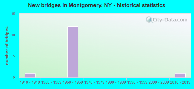
- New bridges - historical statistics
- 11940-1949
- 121960-1969
- 12010-2019

- Reconstructed bridges - Historical Statistics
- 11970-1979
- 01980-1989
- 01990-1999
- 22000-2009


- Bridge Condition - Deck
- 11.1%Excellent
- 66.7%Satisfactory
- 22.2%Fair

- Bridge Condition - Superstructure
- 11.1%Excellent
- 22.2%Good
- 11.1%Satisfactory
- 33.3%Fair
- 22.2%Poor

- Bridge Condition - Substructure
- 11.1%Very good
- 11.1%Good
- 33.3%Satisfactory
- 33.3%Fair
- 11.1%Poor

- Bridge Condition - Channel
- 50.0%Good
- 50.0%Satisfactory
Find on map >> Show street view
Structure Number: 10145, Location: JCT RTE 17K+WALLKILL R (Lat: 41.529150, Lng: -74.237736), Route carried "on" structure: State highway 17K, Year Built: 1940, Year Reconstructed: 1982, Status: Open, Structure Length: 7.01m (23.00ft), Average Daily Traffic: 12,416 (year 2020), Truck Traffic: 7%, Average Future Daily Traffic: 12,474 (year 2040), Design Load: H 20, Features Intersected: WALLKILL RIVER
Minimum Vertical Clearance: 30+ m (98+ ft), Kilometerpoint: 17.039, Lanes on structure: 2, Base Highway Network: Yes, Owner: State Highway Agency, Approaching Roadway Width: 9.1m (29.9ft), Material/Design: Steel, Design/Construction: Truss - Thru, Number Of Spans In Main Unit: 2, Length of Maximum Span: 34.1m (111.9ft), Curb or Sidewalk Widths: Left: 2.1m (6.9ft), Right: 0.0m, Curb-To-Curb Width: 7.3m (24.0ft), Out-to-Out Width: 10.4m (34.1ft)
Condition: Deck: Satisfactory, Superstructure: Fair, Substructure: Fair, Channel: Satisfactory, Operating Rating: 61.7 metric tons, Method Used To Determine Operating Rating: Load Factor (LF), Inventory Rating: 37.2 metric tons, Method Used To Determine Inventory Rating: Load Factor (LF), Structural Evaluation: Somewhat better than minimum adequacy, Deck Geometry: High priority of replacement, Waterway Adequacy: Meets minimum limits, Approach Roadway Alignment: Equal to present desirable criteria, Length Of Structure Improvement: 7.01m (23.00ft), Designated Inspection Frequency: Every 24 months, Critical Feature Inspection Frequency: Every 24 months, Inspection Date: October 2020, Critical Feature Inspection Date: October 2020, Bridge Improvement Cost: $5,455,000, Roadway Improvement Cost: $3,194,000, Total Project Cost: $8,650,000 ( Estimate for 2021), Deck Structure Type: Concrete Cast-file-Place, Wearing Surface/Protective System: Wearing Surface: Integral Concrete, Deck Protection: Epoxy Coated Reinforcing
Find on map >> Show street view
Structure Number: 104098, Location: JCT RTE 211+WALLKILL R (Lat: 41.502361, Lng: -74.263844), Route carried "on" structure: State highway 211, Year Built: 2015, Status: Open, Structure Length: 10.97m (35.99ft), Average Daily Traffic: 5,915 (year 2018), Truck Traffic: 8%, Average Future Daily Traffic: 7,185 (year 2040), Design Load: HS 20, Features Intersected: WALLKILL RIVER
Minimum Vertical Clearance: 30+ m (98+ ft), Kilometerpoint: 33.049, Lanes on structure: 2, Base Highway Network: Yes, Owner: State Highway Agency, Approaching Roadway Width: 11.0m (36.1ft), Skew: 3 degrees, Material/Design: Steel continuous, Design/Construction: Stringer/Multi-beam, Number Of Spans In Main Unit: 3, Length of Maximum Span: 44.5m (146.0ft), Curb-To-Curb Width: 11.0m (36.1ft), Out-to-Out Width: 11.9m (39.0ft)
Condition: Deck: Excellent, Superstructure: Excellent, Substructure: Very good, Channel: Good, Operating Rating: 78.0 metric tons, Method Used To Determine Operating Rating: Load Factor (LF), Inventory Rating: 46.3 metric tons, Method Used To Determine Inventory Rating: Load Factor (LF), Structural Evaluation: Equal to present desirable criteria, Deck Geometry: Meets minimum limits, Waterway Adequacy: Equal to present minimum criteria, Approach Roadway Alignment: Equal to present desirable criteria, Length Of Structure Improvement: 10.97m (35.99ft), Designated Inspection Frequency: Every 24 months, Inspection Date: September 2021, Bridge Improvement Cost: $5,511,000, Roadway Improvement Cost: $3,227,000, Total Project Cost: $8,738,000 ( Estimate for 2021), Deck Structure Type: Concrete Cast-file-Place, Wearing Surface/Protective System: Wearing Surface: Integral Concrete, Deck Protection: Epoxy Coated Reinforcing
Find on map >> Show street view
Structure Number: 105261, Location: 5.2 MI E JCT SH 17 & I84 (Lat: 41.483833, Lng: -74.284456), Route carried "on" structure: Other road , Year Built: 1969, Status: Open, Structure Length: 10.12m (33.20ft), Truck Traffic: 1%, Design Load: HS 20, Features Intersected: 84I 84I83011243 WB, RTE, Facility Carried by Structure: BART BULL ROAD
Minimum Vertical Clearance: 30+ m (98+ ft), Kilometerpoint: 2.832, Lanes on structure: 2, Lanes under structure: 4, Owner: State Highway Agency, Approaching Roadway Width: 8.5m (27.9ft), Skew: 1 degrees, Material/Design: Steel, Design/Construction: Stringer/Multi-beam, Number Of Spans In Main Unit: 3, Length of Maximum Span: 32.9m (107.9ft), Curb or Sidewalk Widths: Left: 0.5m (1.6ft), Right: 0.5m (1.6ft), Curb-To-Curb Width: 7.3m (24.0ft), Out-to-Out Width: 8.8m (28.9ft)
Condition: Deck: Fair, Superstructure: Satisfactory, Substructure: Satisfactory, Operating Rating: 69.0 metric tons, Method Used To Determine Operating Rating: Load and Resistance Factor Rating (LRFR) rating reported by rating factor(RF) method using HL-93 loadings, Inventory Rating: 53.1 metric tons, Method Used To Determine Inventory Rating: Load and Resistance Factor Rating (LRFR) rating reported by rating factor(RF) method using HL-93 loadings, Structural Evaluation: Equal to present minimum criteria, Deck Geometry: Equal to present minimum criteria, Underclear: Meets minimum limits, Approach Roadway Alignment: Equal to present desirable criteria, Length Of Structure Improvement: 10.11m (33.17ft), Designated Inspection Frequency: Every 24 months, Inspection Date: March 2021, Bridge Improvement Cost: $3,333,000, Roadway Improvement Cost: $1,952,000, Total Project Cost: $5,285,000 ( Estimate for 2021), Deck Structure Type: Concrete Cast-file-Place, Wearing Surface/Protective System: Wearing Surface: Integral Concrete
Find on map >> Show street view
Structure Number: 1052621, Location: JCT RTE I84+WALLKILL R (Lat: 41.498931, Lng: -74.252392), Route carried "on" structure: Interstate 84, Year Built: 1969, Year Reconstructed: 2006, Status: Open, Structure Length: 10.94m (35.89ft), Average Daily Traffic: 20,910 (year 2009), Truck Traffic: 21%, Design Load: HS 20, Features Intersected: RTE 416, WALLKILL RIVER
Minimum Vertical Clearance: 30+ m (98+ ft), Kilometerpoint: 42.043, Lanes on structure: 2, Lanes under structure: 2, Base Highway Network: Yes, Owner: State Highway Agency, Approaching Roadway Width: 12.2m (40.0ft), Skew: 1 degrees, Material/Design: Steel, Design/Construction: Stringer/Multi-beam, Number Of Spans In Main Unit: 3, Length of Maximum Span: 35.9m (117.8ft), Curb-To-Curb Width: 11.6m (38.1ft), Out-to-Out Width: 12.5m (41.0ft)
Condition: Deck: Satisfactory, Superstructure: Fair, Substructure: Fair, Channel: Satisfactory, Operating Rating: 55.1 metric tons, Method Used To Determine Operating Rating: Load and Resistance Factor Rating (LRFR) rating reported by rating factor(RF) method using HL-93 loadings, Inventory Rating: 42.4 metric tons, Method Used To Determine Inventory Rating: Load and Resistance Factor Rating (LRFR) rating reported by rating factor(RF) method using HL-93 loadings, Structural Evaluation: Somewhat better than minimum adequacy, Deck Geometry: Equal to present minimum criteria, Underclear: Meets minimum limits, Waterway Adequacy: High priority of replacement, Approach Roadway Alignment: Equal to present desirable criteria, Length Of Structure Improvement: 10.94m (35.89ft), Designated Inspection Frequency: Every 24 months, Inspection Date: August 2021, Bridge Improvement Cost: $5,164,000, Roadway Improvement Cost: $3,024,000, Total Project Cost: $8,188,000 ( Estimate for 2021), Deck Structure Type: Concrete Cast-file-Place, Wearing Surface/Protective System: Wearing Surface: Monolithic Concrete
Find on map >> Show street view
Structure Number: 1052622, Location: JCT RTE I84+WALLKILL R (Lat: 41.498364, Lng: -74.252431), Route carried "on" structure: Interstate 84, Year Built: 1969, Year Reconstructed: 2006, Status: Open, Structure Length: 10.94m (35.89ft), Average Daily Traffic: 20,383 (year 2019), Truck Traffic: 17%, Average Future Daily Traffic: 34,516 (year 2040), Design Load: HS 20, Features Intersected: RTE 416, WALLKILL RIVER
Minimum Vertical Clearance: 30+ m (98+ ft), Kilometerpoint: 42.124, Lanes on structure: 2, Lanes under structure: 2, Base Highway Network: Yes, Owner: State Highway Agency, Approaching Roadway Width: 12.2m (40.0ft), Skew: 1 degrees, Material/Design: Steel, Design/Construction: Stringer/Multi-beam, Number Of Spans In Main Unit: 3, Length of Maximum Span: 35.9m (117.8ft), Curb-To-Curb Width: 11.6m (38.1ft), Out-to-Out Width: 12.5m (41.0ft)
Condition: Deck: Satisfactory, Superstructure: Fair, Substructure: Satisfactory, Channel: Good, Operating Rating: 84.4 metric tons, Method Used To Determine Operating Rating: Load Factor (LF), Inventory Rating: 49.9 metric tons, Method Used To Determine Inventory Rating: Load Factor (LF), Structural Evaluation: Somewhat better than minimum adequacy, Deck Geometry: Equal to present minimum criteria, Underclear: Meets minimum limits, Waterway Adequacy: Equal to present desirable criteria, Approach Roadway Alignment: Equal to present desirable criteria, Length Of Structure Improvement: 10.94m (35.89ft), Designated Inspection Frequency: Every 24 months, Inspection Date: August 2021, Bridge Improvement Cost: $5,137,000, Roadway Improvement Cost: $3,009,000, Total Project Cost: $8,146,000 ( Estimate for 2021), Deck Structure Type: Concrete Cast-file-Place, Wearing Surface/Protective System: Wearing Surface: Monolithic Concrete
Find on map >> Show street view
Structure Number: 1052631, Location: 1.8 MI W JCT I84 & SH 208 (Lat: 41.500875, Lng: -74.238592), Route carried "on" structure: Interstate 84, Year Built: 1969, Status: Open, Structure Length: 4.82m (15.81ft), Average Daily Traffic: 20,910 (year 2009), Truck Traffic: 21%, Average Future Daily Traffic: 29,274 (year 2029), Design Load: HS 20, Features Intersected: MIDDLETOWN & NJ RR
Minimum Vertical Clearance: 30+ m (98+ ft), Kilometerpoint: 43.282, Lanes on structure: 2, Base Highway Network: Yes, Owner: State Highway Agency, Approaching Roadway Width: 12.8m (42.0ft), Skew: 1 degrees, Material/Design: Steel, Design/Construction: Stringer/Multi-beam, Number Of Spans In Main Unit: 3, Length of Maximum Span: 16.1m (52.8ft), Curb-To-Curb Width: 11.9m (39.0ft), Out-to-Out Width: 12.9m (42.3ft)
Condition: Deck: Fair, Superstructure: Poor, Substructure: Fair, Operating Rating: 78.9 metric tons, Method Used To Determine Operating Rating: Load Factor (LF), Inventory Rating: 47.2 metric tons, Method Used To Determine Inventory Rating: Load Factor (LF), Structural Evaluation: Meets minimum limits, Deck Geometry: Equal to present minimum criteria, Underclear: Superior to present desirable criteria, Approach Roadway Alignment: Equal to present desirable criteria, Length Of Structure Improvement: 4.81m (15.78ft), Designated Inspection Frequency: Every 24 months, Inspection Date: October 2021, Bridge Improvement Cost: $2,442,000, Roadway Improvement Cost: $1,430,000, Total Project Cost: $3,871,000 ( Estimate for 2021), Deck Structure Type: Concrete Cast-file-Place, Wearing Surface/Protective System: Wearing Surface: Latex Concrete
Find on map >> Show street view
Structure Number: 1052632, Location: 1.8 MI W JCT I84 & SH 208 (Lat: 41.500222, Lng: -74.238694), Route carried "on" structure: Interstate 84, Year Built: 1969, Status: Open, Structure Length: 5.06m (16.60ft), Average Daily Traffic: 20,383 (year 2019), Truck Traffic: 17%, Average Future Daily Traffic: 34,516 (year 2040), Design Load: HS 20, Features Intersected: MIDDLETOWN & NJ RR
Minimum Vertical Clearance: 30+ m (98+ ft), Kilometerpoint: 43.346, Lanes on structure: 2, Base Highway Network: Yes, Owner: State Highway Agency, Approaching Roadway Width: 12.8m (42.0ft), Skew: 1 degrees, Material/Design: Steel, Design/Construction: Stringer/Multi-beam, Number Of Spans In Main Unit: 3, Length of Maximum Span: 16.1m (52.8ft), Curb-To-Curb Width: 11.9m (39.0ft), Out-to-Out Width: 12.9m (42.3ft)
Condition: Deck: Satisfactory, Superstructure: Poor, Substructure: Poor, Operating Rating: 68.9 metric tons, Method Used To Determine Operating Rating: Load Factor (LF), Inventory Rating: 40.8 metric tons, Method Used To Determine Inventory Rating: Load Factor (LF), Structural Evaluation: Meets minimum limits, Deck Geometry: Equal to present minimum criteria, Underclear: Better than present minimum criteria, Approach Roadway Alignment: Equal to present desirable criteria, Length Of Structure Improvement: 5.05m (16.57ft), Designated Inspection Frequency: Every 24 months, Inspection Date: October 2021, Bridge Improvement Cost: $2,521,000, Roadway Improvement Cost: $1,477,000, Total Project Cost: $3,998,000 ( Estimate for 2021), Deck Structure Type: Concrete Cast-file-Place, Wearing Surface/Protective System: Wearing Surface: Latex Concrete
Find on map >> Show street view
Structure Number: 1052641, Location: 1.5 MI W JCT I84 & SH208 (Lat: 41.501989, Lng: -74.232439), Route carried "on" structure: Interstate 84, Year Built: 1969, Status: Open, Structure Length: 3.17m (10.40ft), Average Daily Traffic: 20,910 (year 2009), Truck Traffic: 21%, Design Load: HS 20, Features Intersected: BEAVER DAM ROAD
Minimum Vertical Clearance: 30+ m (98+ ft), Kilometerpoint: 43.845, Lanes on structure: 2, Lanes under structure: 2, Base Highway Network: Yes, Owner: State Highway Agency, Approaching Roadway Width: 12.2m (40.0ft), Material/Design: Steel, Design/Construction: Stringer/Multi-beam, Number Of Spans In Main Unit: 1, Length of Maximum Span: 30.7m (100.7ft), Curb-To-Curb Width: 12.0m (39.4ft), Out-to-Out Width: 13.0m (42.7ft)
Condition: Deck: Satisfactory, Superstructure: Good, Substructure: Good, Operating Rating: 87.1 metric tons, Method Used To Determine Operating Rating: Load Factor (LF), Inventory Rating: 51.7 metric tons, Method Used To Determine Inventory Rating: Load Factor (LF), Structural Evaluation: Better than present minimum criteria, Deck Geometry: Equal to present minimum criteria, Underclear: Somewhat better than minimum adequacy, Approach Roadway Alignment: Equal to present desirable criteria, Length Of Structure Improvement: 3.16m (10.37ft), Designated Inspection Frequency: Every 24 months, Inspection Date: July 2021, Bridge Improvement Cost: $1,853,000, Roadway Improvement Cost: $1,085,000, Total Project Cost: $2,939,000 ( Estimate for 2021), Deck Structure Type: Concrete Cast-file-Place, Wearing Surface/Protective System: Wearing Surface: Integral Concrete
Find on map >> Show street view
Structure Number: 1052642, Location: 1.5 MI W JCT RTS I84+208 (Lat: 41.501381, Lng: -74.232331), Route carried "on" structure: Interstate 84, Year Built: 1969, Status: Open, Structure Length: 3.38m (11.09ft), Average Daily Traffic: 20,383 (year 2019), Truck Traffic: 17%, Average Future Daily Traffic: 34,516 (year 2040), Design Load: HS 20+Mod, Features Intersected: BEAVER DAM RD
Minimum Vertical Clearance: 30+ m (98+ ft), Kilometerpoint: 43.910, Lanes on structure: 2, Lanes under structure: 2, Base Highway Network: Yes, Owner: State Highway Agency, Approaching Roadway Width: 12.2m (40.0ft), Material/Design: Steel, Design/Construction: Stringer/Multi-beam, Number Of Spans In Main Unit: 1, Length of Maximum Span: 32.6m (107.0ft), Curb-To-Curb Width: 12.0m (39.4ft), Out-to-Out Width: 12.9m (42.3ft)
Condition: Deck: Satisfactory, Superstructure: Good, Substructure: Satisfactory, Operating Rating: 88.9 metric tons, Method Used To Determine Operating Rating: Load Factor (LF), Inventory Rating: 53.5 metric tons, Method Used To Determine Inventory Rating: Load Factor (LF), Structural Evaluation: Equal to present minimum criteria, Deck Geometry: Equal to present minimum criteria, Underclear: Somewhat better than minimum adequacy, Approach Roadway Alignment: Equal to present desirable criteria, Length Of Structure Improvement: 3.38m (11.09ft), Designated Inspection Frequency: Every 24 months, Inspection Date: July 2021, Bridge Improvement Cost: $1,989,000, Roadway Improvement Cost: $1,165,000, Total Project Cost: $3,154,000 ( Estimate for 2021), Deck Structure Type: Concrete Cast-file-Place, Wearing Surface/Protective System: Wearing Surface: Integral Concrete
Find on map >> Show street view
Structure Number: 105261, Location: 5.2 MI E JCT SH 17 & I84 (Lat: 41.483833, Lng: -74.284456), Route carried "under" structure: Interstate 84, Year Built: 1969, Structure Length: 0. m, Average Daily Traffic: 9,000 (year 1971), Features Intersected: 84I 84I83011243 WB, RTE, Facility Carried by Structure: BART BULL ROAD
Minimum Vertical Clearance: 5.94m (19.49ft), Kilometerpoint: 39.244, Lanes on structure: 2, Lanes under structure: 2, Material/Design: Steel, Design/Construction: Stringer/Multi-beam, Length of Maximum Span: 32.9m (107.9ft)
Find on map >> Show street view
Structure Number: 1052621, Location: JCT RTE I84+WALLKILL R (Lat: 41.498931, Lng: -74.252392), Route carried "under" structure: State highway 416, Year Built: 1969, Structure Length: 0. m, Average Daily Traffic: 3,745 (year 2002), Features Intersected: RTE 416, WALLKILL RIVER, Facility Carried by Structure: RTE I84
Minimum Vertical Clearance: 5.56m (18.24ft), Kilometerpoint: 5.294, Lanes on structure: 2, Lanes under structure: 2, Material/Design: Steel, Design/Construction: Stringer/Multi-beam, Length of Maximum Span: 35.9m (117.8ft)
Find on map >> Show street view
Structure Number: 1052622, Location: JCT RTE I84+WALLKILL R (Lat: 41.498364, Lng: -74.252431), Route carried "under" structure: State highway 416, Year Built: 1969, Structure Length: 0. m, Average Daily Traffic: 1,200 (year 1971), Features Intersected: RTE 416, WALLKILL RIVER, Facility Carried by Structure: RTE I84
Minimum Vertical Clearance: 5.41m (17.75ft), Kilometerpoint: 21.384, Lanes on structure: 2, Lanes under structure: 2, Material/Design: Steel, Design/Construction: Stringer/Multi-beam, Length of Maximum Span: 35.9m (117.8ft)
Find on map >> Show street view
Structure Number: 1052641, Location: 1.5 MI W JCT I84 & SH208 (Lat: 41.501989, Lng: -74.232439), Route carried "under" structure: Other road , Year Built: 1969, Structure Length: 0. m, Features Intersected: BEAVER DAM ROAD, Facility Carried by Structure: RTE I84
Minimum Vertical Clearance: 6.22m (20.41ft), Kilometerpoint: 1.110, Lanes on structure: 2, Lanes under structure: 2, Material/Design: Steel, Design/Construction: Stringer/Multi-beam, Length of Maximum Span: 30.7m (100.7ft)
Find on map >> Show street view
Structure Number: 1052642, Location: 1.5 MI W JCT RTS I84+208 (Lat: 41.501381, Lng: -74.232331), Route carried "under" structure: Other road , Year Built: 1969, Structure Length: 0. m, Features Intersected: BEAVER DAM RD, Facility Carried by Structure: RTE I84
Minimum Vertical Clearance: 5.36m (17.59ft), Kilometerpoint: 0.000, Lanes on structure: 2, Lanes under structure: 2, Material/Design: Steel, Design/Construction: Stringer/Multi-beam, Length of Maximum Span: 32.6m (107.0ft)