Bridge Statistics for Montgomery, Ohio (OH)
Condition, Traffic, Stress, Structural Evaluation, Project Costs
- National Bridge Inventory (NBI) Statistics
- 33Number of bridges
- 404ft / 123mTotal length
- 2,137,524Total average daily traffic
- 228,108Total average daily truck traffic
- National Bridge Inventory (NBI) Registered Bridges for Montgomery
- No street view available for this location
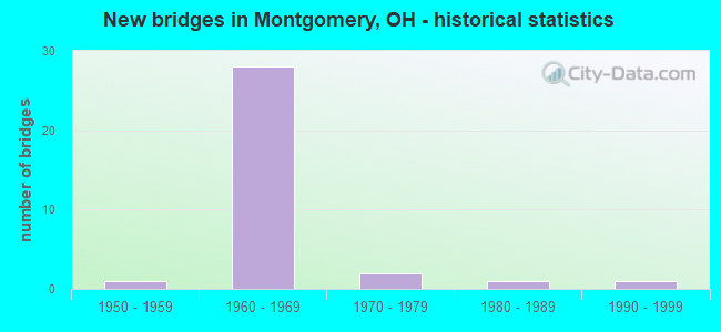
- New bridges - historical statistics
- 11950-1959
- 281960-1969
- 21970-1979
- 11980-1989
- 11990-1999

- Reconstructed bridges - Historical Statistics
- 21990-1999
- 22000-2009


- Bridge Condition - Deck
- 6.7%Excellent
- 6.7%Very good
- 73.3%Good
- 13.3%Satisfactory

- Bridge Condition - Superstructure
- 6.7%Excellent
- 20.0%Very good
- 53.3%Good
- 13.3%Satisfactory
- 6.7%Poor

- Bridge Condition - Substructure
- 6.7%Excellent
- 80.0%Good
- 6.7%Satisfactory
- 6.7%Fair

- Bridge Condition - Channel
- 20.0%Excellent
- 40.0%Good
- 40.0%Satisfactory

- Bridge Condition - Culverts
- 25.0%Good
- 75.0%Satisfactory
Find on map >> Show street view
Structure Number: 3101037, Location: 0.5 MI SOUTH OF 275 (Lat: 39.254719, Lng: -84.343581), Route carried "on" structure: US 22, Year Built: 1992, Status: Open, Structure Length: 1.13m (3.71ft), Average Daily Traffic: 20,820 (year 2015), Truck Traffic: 4%, Average Future Daily Traffic: 28,898 (year 2035), Design Load: HS 20+Mod, Features Intersected: N BRANCH SYCAMORE CREEK
Minimum Vertical Clearance: 30+ m (98+ ft), Kilometerpoint: 25.122, Lanes on structure: 4, Base Highway Network: Yes, Owner: State Highway Agency, Approaching Roadway Width: 18.3m (60.0ft), Skew: 1 degrees, Material/Design: Concrete, Design/Construction: Culvert, Number Of Spans In Main Unit: 1, Length of Maximum Span: 10.7m (35.1ft)
Condition: Channel: Good, Culverts: Satisfactory, Operating Rating: 40.8 metric tons, Method Used To Determine Operating Rating: Field evaluation and documented engineering judgment, Inventory Rating: 32.7 metric tons, Method Used To Determine Inventory Rating: Field evaluation and documented engineering judgment, Structural Evaluation: Equal to present minimum criteria, Waterway Adequacy: Equal to present desirable criteria, Approach Roadway Alignment: Equal to present desirable criteria, Designated Inspection Frequency: Every 12 months, Inspection Date: June 2021
Find on map >> Show street view
Structure Number: 3101053, Location: OVER I275 (Lat: 39.260950, Lng: -84.338481), Route carried "on" structure: US 22, Year Built: 1966, Year Reconstructed: 2006, Status: Open, Structure Length: 9.37m (30.74ft), Average Daily Traffic: 25,786 (year 2015), Truck Traffic: 4%, Average Future Daily Traffic: 35,791 (year 2035), Design Load: HS 25 or greater, Features Intersected: IR 275
Minimum Vertical Clearance: 30+ m (98+ ft), Kilometerpoint: 25.991, Lanes on structure: 6, Lanes under structure: 4, Base Highway Network: Yes, Owner: State Highway Agency, Approaching Roadway Width: 27.4m (89.9ft), Material/Design: Steel continuous, Design/Construction: Stringer/Multi-beam, Number Of Spans In Main Unit: 4, Length of Maximum Span: 30.9m (101.4ft), Curb or Sidewalk Widths: Left: 1.8m (5.9ft), Right: 0.0m, Curb-To-Curb Width: 25.6m (84.0ft), Out-to-Out Width: 31.9m (104.7ft)
Condition: Deck: Very good, Superstructure: Good, Substructure: Good, Operating Rating: 45.4 metric tons, Method Used To Determine Operating Rating: Load and Resistance Factor Rating (LRFR) rating reported by rating factor(RF) method using HL-93 loadings, Inventory Rating: 35.6 metric tons, Method Used To Determine Inventory Rating: Load and Resistance Factor Rating (LRFR) rating reported by rating factor(RF) method using HL-93 loadings, Structural Evaluation: Better than present minimum criteria, Deck Geometry: Somewhat better than minimum adequacy, Underclear: Somewhat better than minimum adequacy, Approach Roadway Alignment: Equal to present minimum criteria, Designated Inspection Frequency: Every 24 months, Inspection Date: June 2021, Deck Structure Type: Concrete Cast-file-Place, Wearing Surface/Protective System: Wearing Surface: Monolithic Concrete, Membrane: Epoxy, Deck Protection: Epoxy Coated Reinforcing
Find on map >> Show street view
Structure Number: 3105164, Location: COOPER RD OVER 71 (Lat: 39.228881, Lng: -84.366861), Route carried "on" structure: County highway COOPR, Year Built: 1966, Year Reconstructed: 2006, Status: Open, Structure Length: 7.96m (26.12ft), Average Daily Traffic: 9,686 (year 2018), Truck Traffic: 5%, Average Future Daily Traffic: 188,689 (year 2038), Design Load: H 20, Features Intersected: I71, Facility Carried by Structure: COOPER RD.
Minimum Vertical Clearance: 30+ m (98+ ft), Kilometerpoint: 24.140, Lanes on structure: 2, Lanes under structure: 6, Owner: State Highway Agency, Approaching Roadway Width: 6.1m (20.0ft), Skew: 1 degrees, Material/Design: Steel continuous, Design/Construction: Stringer/Multi-beam, Number Of Spans In Main Unit: 4, Length of Maximum Span: 24.2m (79.4ft), Curb or Sidewalk Widths: Left: 1.8m (5.9ft), Right: 1.8m (5.9ft), Curb-To-Curb Width: 9.1m (29.9ft), Out-to-Out Width: 12.9m (42.3ft)
Condition: Deck: Satisfactory, Superstructure: Satisfactory, Substructure: Good, Operating Rating: 45.4 metric tons, Method Used To Determine Operating Rating: Load and Resistance Factor Rating (LRFR) rating reported by rating factor(RF) method using HL-93 loadings, Inventory Rating: 32.4 metric tons, Method Used To Determine Inventory Rating: Load and Resistance Factor Rating (LRFR) rating reported by rating factor(RF) method using HL-93 loadings, Structural Evaluation: Equal to present minimum criteria, Deck Geometry: Meets minimum limits, Underclear: High priority of corrective action, Approach Roadway Alignment: Superior to present desirable criteria, Designated Inspection Frequency: Every 12 months, Inspection Date: March 2021, Deck Structure Type: Concrete Cast-file-Place, Wearing Surface/Protective System: Wearing Surface: Integral Concrete
Find on map >> Show street view
Structure Number: 3107264, Location: .9 MI N OF SR 126-COOPER (Lat: 39.241800, Lng: -84.366350), Route carried "on" structure: City street ZIGZG, Year Built: 1968, Status: Open, Structure Length: 7.39m (24.25ft), Average Daily Traffic: 100 (year 2018), Truck Traffic: 10%, Average Future Daily Traffic: 188,689 (year 2038), Design Load: H 15, Features Intersected: I71, Facility Carried by Structure: ZIG ZAG RD
Minimum Vertical Clearance: 30+ m (98+ ft), Kilometerpoint: 20.921, Lanes on structure: 2, Lanes under structure: 6, Owner: State Highway Agency, Approaching Roadway Width: 9.1m (29.9ft), Material/Design: Steel continuous, Design/Construction: Stringer/Multi-beam, Number Of Spans In Main Unit: 4, Length of Maximum Span: 21.3m (69.9ft), Curb or Sidewalk Widths: Left: 0.5m (1.6ft), Right: 1.5m (4.9ft), Curb-To-Curb Width: 9.1m (29.9ft), Out-to-Out Width: 12.0m (39.4ft)
Condition: Deck: Good, Superstructure: Satisfactory, Substructure: Good, Operating Rating: 32.4 metric tons, Method Used To Determine Operating Rating: Load and Resistance Factor Rating (LRFR) rating reported by rating factor(RF) method using HL-93 loadings, Inventory Rating: 25.9 metric tons, Method Used To Determine Inventory Rating: Load and Resistance Factor Rating (LRFR) rating reported by rating factor(RF) method using HL-93 loadings, Structural Evaluation: Equal to present minimum criteria, Deck Geometry: Better than present minimum criteria, Underclear: Meets minimum limits, Approach Roadway Alignment: Equal to present desirable criteria, Designated Inspection Frequency: Every 12 months, Inspection Date: March 2021, Deck Structure Type: Concrete Cast-file-Place, Wearing Surface/Protective System: Wearing Surface: Latex Concrete
Find on map >> Show street view
Structure Number: 3107299, Location: 1.3 MI N OF SR 126-COOPER (Lat: 39.248111, Lng: -84.365689), Route carried "on" structure: Interstate 71, Year Built: 1966, Status: Open, Structure Length: 0.67m (2.20ft), Average Daily Traffic: 117,916 (year 2018), Truck Traffic: 14%, Average Future Daily Traffic: 163,667 (year 2038), Design Load: HS 20, Features Intersected: TRIB N BR SYCAMORE CREEK
Minimum Vertical Clearance: 30+ m (98+ ft), Kilometerpoint: 25.331, Lanes on structure: 5, Base Highway Network: Yes, Owner: State Highway Agency, Approaching Roadway Width: 32.9m (107.9ft), Skew: 20 degrees, Material/Design: Steel, Design/Construction: Culvert, Number Of Spans In Main Unit: 2, Length of Maximum Span: 2.4m (7.9ft)
Condition: Channel: Satisfactory, Culverts: Good, Operating Rating: 42.1 metric tons, Method Used To Determine Operating Rating: Load Factor (LF) rating reported by rating factor (RF) method using MS18 loading, Inventory Rating: 32.4 metric tons, Method Used To Determine Inventory Rating: Load Factor (LF) rating reported by rating factor (RF) method using MS18 loading, Structural Evaluation: Better than present minimum criteria, Waterway Adequacy: Better than present minimum criteria, Approach Roadway Alignment: Superior to present desirable criteria, Designated Inspection Frequency: Every 24 months, Inspection Date: March 2021
Find on map >> Show street view
Structure Number: 3107329, Location: 1.4 MI N OF SR 126-COOPER (Lat: 39.249289, Lng: -84.365661), Route carried "on" structure: Interstate 71, Year Built: 1968, Status: Open, Structure Length: 5.48m (17.98ft), Average Daily Traffic: 58,958 (year 2018), Truck Traffic: 14%, Average Future Daily Traffic: 81,834 (year 2038), Design Load: HS 20+Mod, Features Intersected: PFEIFFER ROAD
Minimum Vertical Clearance: 30+ m (98+ ft), Kilometerpoint: 25.444, Lanes on structure: 3, Lanes under structure: 4, Base Highway Network: Yes, Owner: State Highway Agency, Approaching Roadway Width: 17.7m (58.1ft), Skew: 1 degrees, Material/Design: Steel continuous, Design/Construction: Stringer/Multi-beam, Number Of Spans In Main Unit: 3, Length of Maximum Span: 26.1m (85.6ft), Curb-To-Curb Width: 17.4m (57.1ft), Out-to-Out Width: 18.5m (60.7ft)
Condition: Deck: Satisfactory, Superstructure: Good, Substructure: Good, Operating Rating: 42.1 metric tons, Method Used To Determine Operating Rating: Allowable Stress (AS) rating reported by rating factor (RF) method using MS18 loading, Inventory Rating: 32.4 metric tons, Method Used To Determine Inventory Rating: Allowable Stress (AS) rating reported by rating factor (RF) method using MS18 loading, Structural Evaluation: Better than present minimum criteria, Deck Geometry: Better than present minimum criteria, Underclear: High priority of corrective action, Approach Roadway Alignment: Superior to present desirable criteria, Designated Inspection Frequency: Every 12 months, Inspection Date: March 2021, Deck Structure Type: Concrete Cast-file-Place, Wearing Surface/Protective System: Wearing Surface: Integral Concrete
Find on map >> Show street view
Structure Number: 3107353, Location: 1.4 MI N OF SR126-COOPER (Lat: 39.249231, Lng: -84.365439), Route carried "on" structure: Interstate 71, Year Built: 1968, Status: Open, Structure Length: 5.48m (17.98ft), Average Daily Traffic: 58,958 (year 2018), Truck Traffic: 14%, Average Future Daily Traffic: 81,834 (year 2038), Design Load: HS 20+Mod, Features Intersected: PFEIFFER ROAD
Minimum Vertical Clearance: 30+ m (98+ ft), Kilometerpoint: 25.444, Lanes on structure: 3, Lanes under structure: 4, Base Highway Network: Yes, Owner: State Highway Agency, Approaching Roadway Width: 18.3m (60.0ft), Skew: 1 degrees, Material/Design: Steel continuous, Design/Construction: Stringer/Multi-beam, Number Of Spans In Main Unit: 3, Length of Maximum Span: 26.1m (85.6ft), Curb-To-Curb Width: 17.4m (57.1ft), Out-to-Out Width: 18.5m (60.7ft)
Condition: Deck: Good, Superstructure: Good, Substructure: Good, Operating Rating: 42.1 metric tons, Method Used To Determine Operating Rating: Allowable Stress (AS) rating reported by rating factor (RF) method using MS18 loading, Inventory Rating: 32.4 metric tons, Method Used To Determine Inventory Rating: Allowable Stress (AS) rating reported by rating factor (RF) method using MS18 loading, Structural Evaluation: Better than present minimum criteria, Deck Geometry: Better than present minimum criteria, Underclear: High priority of corrective action, Approach Roadway Alignment: Superior to present desirable criteria, Designated Inspection Frequency: Every 24 months, Inspection Date: March 2021, Deck Structure Type: Concrete Cast-file-Place, Wearing Surface/Protective System: Wearing Surface: Integral Concrete
Find on map >> Show street view
Structure Number: 3107442, Location: I275 RAMP OVER I 71 (Lat: 39.269081, Lng: -84.353419), Route carried "on" structure: Ramp Interstate 71, Year Built: 1966, Status: Open, Structure Length: 9.85m (32.32ft), Average Daily Traffic: 138,400 (year 2014), Truck Traffic: 10%, Average Future Daily Traffic: 192,099 (year 2034), Design Load: HS 20, Features Intersected: IR 71
Minimum Vertical Clearance: 30+ m (98+ ft), Kilometerpoint: 27.922, Lanes on structure: 1, Lanes under structure: 8, Owner: State Highway Agency, Approaching Roadway Width: 7.3m (24.0ft), Skew: 6 degrees, Material/Design: Steel continuous, Design/Construction: Stringer/Multi-beam, Number Of Spans In Main Unit: 5, Length of Maximum Span: 23.0m (75.5ft), Curb-To-Curb Width: 7.8m (25.6ft), Out-to-Out Width: 9.0m (29.5ft)
Condition: Deck: Good, Superstructure: Good, Substructure: Good, Operating Rating: 45.4 metric tons, Method Used To Determine Operating Rating: Load and Resistance Factor Rating (LRFR) rating reported by rating factor(RF) method using HL-93 loadings, Inventory Rating: 35.6 metric tons, Method Used To Determine Inventory Rating: Load and Resistance Factor Rating (LRFR) rating reported by rating factor(RF) method using HL-93 loadings, Structural Evaluation: Better than present minimum criteria, Deck Geometry: Better than present minimum criteria, Underclear: Somewhat better than minimum adequacy, Approach Roadway Alignment: Superior to present desirable criteria, Designated Inspection Frequency: Every 24 months, Inspection Date: March 2021, Deck Structure Type: Concrete Cast-file-Place, Wearing Surface/Protective System: Wearing Surface: Integral Concrete
Find on map >> Show street view
Structure Number: 3107531, Location: .2 MI N OF IR 275 (Lat: 39.273069, Lng: -84.348531), Route carried "on" structure: Ramp Interstate 71, Year Built: 1966, Status: Open, Structure Length: 7.50m (24.61ft), Average Daily Traffic: 129,170 (year 2009), Average Future Daily Traffic: 179,288 (year 2029), Design Load: HS 20+Mod, Features Intersected: RAMP A
Minimum Vertical Clearance: 30+ m (98+ ft), Kilometerpoint: 28.534, Lanes on structure: 1, Lanes under structure: 8, Owner: State Highway Agency, Approaching Roadway Width: 7.8m (25.6ft), Material/Design: Steel continuous, Design/Construction: Stringer/Multi-beam, Number Of Spans In Main Unit: 4, Length of Maximum Span: 20.7m (67.9ft), Curb-To-Curb Width: 7.8m (25.6ft), Out-to-Out Width: 9.2m (30.2ft)
Condition: Deck: Good, Superstructure: Good, Substructure: Good, Operating Rating: 38.9 metric tons, Method Used To Determine Operating Rating: Load and Resistance Factor Rating (LRFR) rating reported by rating factor(RF) method using HL-93 loadings, Inventory Rating: 29.2 metric tons, Method Used To Determine Inventory Rating: Load and Resistance Factor Rating (LRFR) rating reported by rating factor(RF) method using HL-93 loadings, Structural Evaluation: Better than present minimum criteria, Deck Geometry: Better than present minimum criteria, Underclear: High priority of corrective action, Approach Roadway Alignment: Equal to present desirable criteria, Designated Inspection Frequency: Every 24 months, Inspection Date: March 2021, Deck Structure Type: Concrete Cast-file-Place, Wearing Surface/Protective System: Wearing Surface: Integral Concrete
Find on map >> Show street view
Structure Number: 3113205, Location: OVER IR 71 (Lat: 39.271361, Lng: -84.351369), Route carried "on" structure: Interstate 275, Year Built: 1966, Year Reconstructed: 2003, Status: Open, Structure Length: 8.58m (28.15ft), Average Daily Traffic: 18,970 (year 2018), Truck Traffic: 6%, Average Future Daily Traffic: 26,330 (year 2038), Design Load: HS 20+Mod, Features Intersected: IR 71
Minimum Vertical Clearance: 30+ m (98+ ft), Kilometerpoint: 50.244, Lanes on structure: 4, Lanes under structure: 7, Base Highway Network: Yes, Owner: State Highway Agency, Approaching Roadway Width: 21.9m (71.9ft), Material/Design: Steel continuous, Design/Construction: Stringer/Multi-beam, Number Of Spans In Main Unit: 4, Length of Maximum Span: 25.9m (85.0ft), Curb-To-Curb Width: 21.9m (71.9ft), Out-to-Out Width: 23.0m (75.5ft)
Condition: Deck: Good, Superstructure: Very good, Substructure: Good, Operating Rating: 45.4 metric tons, Method Used To Determine Operating Rating: Load and Resistance Factor Rating (LRFR) rating reported by rating factor(RF) method using HL-93 loadings, Inventory Rating: 35.6 metric tons, Method Used To Determine Inventory Rating: Load and Resistance Factor Rating (LRFR) rating reported by rating factor(RF) method using HL-93 loadings, Structural Evaluation: Better than present minimum criteria, Deck Geometry: Better than present minimum criteria, Underclear: High priority of corrective action, Approach Roadway Alignment: Equal to present desirable criteria, Designated Inspection Frequency: Every 24 months, Inspection Date: April 2021, Deck Structure Type: Concrete Cast-file-Place, Wearing Surface/Protective System: Wearing Surface: Monolithic Concrete, Deck Protection: Epoxy Coated Reinforcing
Find on map >> Show street view
Structure Number: 3113264, Location: OVER IR 71 (Lat: 39.271161, Lng: -84.351619), Route carried "on" structure: Interstate 275, Year Built: 1966, Year Reconstructed: 2003, Status: Open, Structure Length: 8.58m (28.15ft), Average Daily Traffic: 18,970 (year 2018), Truck Traffic: 6%, Average Future Daily Traffic: 26,330 (year 2038), Design Load: HS 20+Mod, Features Intersected: IR 71
Minimum Vertical Clearance: 30+ m (98+ ft), Kilometerpoint: 50.244, Lanes on structure: 4, Lanes under structure: 7, Base Highway Network: Yes, Owner: State Highway Agency, Approaching Roadway Width: 23.7m (77.8ft), Material/Design: Steel continuous, Design/Construction: Stringer/Multi-beam, Number Of Spans In Main Unit: 4, Length of Maximum Span: 25.9m (85.0ft), Curb-To-Curb Width: 23.7m (77.8ft), Out-to-Out Width: 24.8m (81.4ft)
Condition: Deck: Good, Superstructure: Very good, Substructure: Good, Operating Rating: 48.6 metric tons, Method Used To Determine Operating Rating: Load and Resistance Factor Rating (LRFR) rating reported by rating factor(RF) method using HL-93 loadings, Inventory Rating: 38.9 metric tons, Method Used To Determine Inventory Rating: Load and Resistance Factor Rating (LRFR) rating reported by rating factor(RF) method using HL-93 loadings, Structural Evaluation: Better than present minimum criteria, Deck Geometry: Superior to present desirable criteria, Underclear: High priority of corrective action, Approach Roadway Alignment: Equal to present desirable criteria, Designated Inspection Frequency: Every 24 months, Inspection Date: April 2021, Deck Structure Type: Concrete Cast-file-Place, Wearing Surface/Protective System: Wearing Surface: Monolithic Concrete, Deck Protection: Epoxy Coated Reinforcing
Find on map >> Show street view
Structure Number: 3113299, Location: .1 MI E OF IR 71 (Lat: 39.269819, Lng: -84.349289), Route carried "on" structure: Interstate 275, Year Built: 1966, Status: Open, Structure Length: 6.30m (20.67ft), Average Daily Traffic: 18,970 (year 2018), Truck Traffic: 6%, Average Future Daily Traffic: 26,330 (year 2038), Design Load: HS 20+Mod, Features Intersected: IR 275 RAMPS FOR IR 71*N
Minimum Vertical Clearance: 30+ m (98+ ft), Kilometerpoint: 50.485, Lanes on structure: 1, Lanes under structure: 2, Base Highway Network: Yes, Owner: State Highway Agency, Approaching Roadway Width: 23.3m (76.4ft), Skew: 1 degrees, Material/Design: Steel continuous, Design/Construction: Stringer/Multi-beam, Number Of Spans In Main Unit: 4, Length of Maximum Span: 17.1m (56.1ft), Curb-To-Curb Width: 23.3m (76.4ft), Out-to-Out Width: 24.3m (79.7ft)
Condition: Deck: Good, Superstructure: Good, Substructure: Good, Operating Rating: 42.1 metric tons, Method Used To Determine Operating Rating: Allowable Stress (AS) rating reported by rating factor (RF) method using MS18 loading, Inventory Rating: 32.4 metric tons, Method Used To Determine Inventory Rating: Allowable Stress (AS) rating reported by rating factor (RF) method using MS18 loading, Structural Evaluation: Better than present minimum criteria, Deck Geometry: Superior to present desirable criteria, Underclear: High priority of corrective action, Approach Roadway Alignment: Equal to present desirable criteria, Designated Inspection Frequency: Every 24 months, Inspection Date: April 2021, Deck Structure Type: Concrete Cast-file-Place, Wearing Surface/Protective System: Wearing Surface: Monolithic Concrete, Deck Protection: Epoxy Coated Reinforcing
Find on map >> Show street view
Structure Number: 3113329, Location: .1 MI E OF IR 71 (Lat: 39.269700, Lng: -84.349639), Route carried "on" structure: Interstate 275, Year Built: 1966, Status: Open, Structure Length: 6.30m (20.67ft), Average Daily Traffic: 18,970 (year 2018), Truck Traffic: 6%, Average Future Daily Traffic: 26,330 (year 2038), Design Load: HS 20+Mod, Features Intersected: IR 275 RAMPS FOR IR 71*N
Minimum Vertical Clearance: 30+ m (98+ ft), Kilometerpoint: 50.485, Lanes on structure: 3, Lanes under structure: 2, Base Highway Network: Yes, Owner: State Highway Agency, Approaching Roadway Width: 18.7m (61.4ft), Skew: 1 degrees, Material/Design: Steel continuous, Design/Construction: Stringer/Multi-beam, Number Of Spans In Main Unit: 4, Length of Maximum Span: 17.1m (56.1ft), Curb-To-Curb Width: 18.7m (61.4ft), Out-to-Out Width: 19.7m (64.6ft)
Condition: Deck: Good, Superstructure: Very good, Substructure: Good, Operating Rating: 42.1 metric tons, Method Used To Determine Operating Rating: Allowable Stress (AS) rating reported by rating factor (RF) method using MS18 loading, Inventory Rating: 32.4 metric tons, Method Used To Determine Inventory Rating: Allowable Stress (AS) rating reported by rating factor (RF) method using MS18 loading, Structural Evaluation: Better than present minimum criteria, Deck Geometry: Superior to present desirable criteria, Underclear: High priority of corrective action, Approach Roadway Alignment: Equal to present desirable criteria, Designated Inspection Frequency: Every 24 months, Inspection Date: April 2021, Deck Structure Type: Concrete Cast-file-Place, Wearing Surface/Protective System: Wearing Surface: Monolithic Concrete, Deck Protection: Epoxy Coated Reinforcing
Find on map >> Show street view
Structure Number: 3113353, Location: .6 MI E OF IR 71 (Lat: 39.264550, Lng: -84.342469), Route carried "on" structure: County highway C0256, Year Built: 1966, Status: Open, Structure Length: 12.70m (41.67ft), Average Daily Traffic: 13,779 (year 2015), Truck Traffic: 3%, Average Future Daily Traffic: 112,904 (year 2035), Design Load: H 20, Features Intersected: I275, Facility Carried by Structure: CORNELL RD
Minimum Vertical Clearance: 30+ m (98+ ft), Kilometerpoint: 5.955, Lanes on structure: 2, Lanes under structure: 7, Owner: State Highway Agency, Approaching Roadway Width: 10.2m (33.5ft), Skew: 4 degrees, Material/Design: Steel continuous, Design/Construction: Stringer/Multi-beam, Number Of Spans In Main Unit: 4, Length of Maximum Span: 41.9m (137.5ft), Curb-To-Curb Width: 10.2m (33.5ft), Out-to-Out Width: 11.2m (36.7ft)
Condition: Deck: Good, Superstructure: Poor, Substructure: Satisfactory, Operating Rating: 35.6 metric tons, Method Used To Determine Operating Rating: Load and Resistance Factor Rating (LRFR) rating reported by rating factor(RF) method using HL-93 loadings, Inventory Rating: 29.2 metric tons, Method Used To Determine Inventory Rating: Load and Resistance Factor Rating (LRFR) rating reported by rating factor(RF) method using HL-93 loadings, Structural Evaluation: Meets minimum limits, Deck Geometry: Meets minimum limits, Underclear: High priority of corrective action, Approach Roadway Alignment: Equal to present desirable criteria, Designated Inspection Frequency: Every 12 months, Inspection Date: October 2021, Deck Structure Type: Concrete Cast-file-Place, Wearing Surface/Protective System: Wearing Surface: Monolithic Concrete, Deck Protection: Epoxy Coated Reinforcing
Find on map >> Show street view
Structure Number: 3113418, Location: .5 MI W OF US 22 (Lat: 39.256261, Lng: -84.331289), Route carried "on" structure: City street WELER, Year Built: 1969, Status: Open, Structure Length: 13.14m (43.11ft), Average Daily Traffic: 100 (year 1970), Truck Traffic: 10%, Average Future Daily Traffic: 132,948 (year 1990), Design Load: H 15, Features Intersected: I275, Facility Carried by Structure: WELLER RD
Minimum Vertical Clearance: 30+ m (98+ ft), Kilometerpoint: 0.966, Lanes on structure: 2, Lanes under structure: 6, Owner: State Highway Agency, Approaching Roadway Width: 9.8m (32.2ft), Skew: 5 degrees, Material/Design: Steel continuous, Design/Construction: Stringer/Multi-beam, Number Of Spans In Main Unit: 4, Length of Maximum Span: 39.8m (130.6ft), Curb-To-Curb Width: 9.8m (32.2ft), Out-to-Out Width: 11.1m (36.4ft)
Condition: Deck: Good, Superstructure: Good, Substructure: Good, Operating Rating: 42.1 metric tons, Method Used To Determine Operating Rating: Load and Resistance Factor Rating (LRFR) rating reported by rating factor(RF) method using HL-93 loadings, Inventory Rating: 32.4 metric tons, Method Used To Determine Inventory Rating: Load and Resistance Factor Rating (LRFR) rating reported by rating factor(RF) method using HL-93 loadings, Structural Evaluation: Better than present minimum criteria, Deck Geometry: Equal to present desirable criteria, Underclear: High priority of corrective action, Approach Roadway Alignment: Superior to present desirable criteria, Designated Inspection Frequency: Every 24 months, Inspection Date: December 2021, Deck Structure Type: Concrete Cast-file-Place, Wearing Surface/Protective System: Wearing Surface: Monolithic Concrete, Deck Protection: Epoxy Coated Reinforcing
Find on map >> Show street view
Structure Number: 3113531, Location: 2 MI E OF US 22 (Lat: 39.248461, Lng: -84.306500), Route carried "on" structure: County highway C0307, Year Built: 1970, Status: Open, Structure Length: 9.55m (31.33ft), Average Daily Traffic: 6,766 (year 2018), Truck Traffic: 5%, Average Future Daily Traffic: 132,948 (year 2038), Design Load: H 20, Features Intersected: I275, Facility Carried by Structure: HOPEWELL RD C307
Minimum Vertical Clearance: 30+ m (98+ ft), Kilometerpoint: 2.012, Lanes on structure: 2, Lanes under structure: 6, Owner: State Highway Agency, Approaching Roadway Width: 9.8m (32.2ft), Skew: 2 degrees, Material/Design: Steel continuous, Design/Construction: Stringer/Multi-beam, Number Of Spans In Main Unit: 4, Length of Maximum Span: 28.4m (93.2ft), Curb-To-Curb Width: 9.8m (32.2ft), Out-to-Out Width: 10.9m (35.8ft)
Condition: Deck: Good, Superstructure: Good, Substructure: Fair, Operating Rating: 42.1 metric tons, Method Used To Determine Operating Rating: Load Factor (LF) rating reported by rating factor (RF) method using MS18 loading, Inventory Rating: 32.4 metric tons, Method Used To Determine Inventory Rating: Load Factor (LF) rating reported by rating factor (RF) method using MS18 loading, Structural Evaluation: Somewhat better than minimum adequacy, Deck Geometry: Meets minimum limits, Underclear: High priority of corrective action, Approach Roadway Alignment: Superior to present desirable criteria, Designated Inspection Frequency: Every 12 months, Inspection Date: April 2021, Deck Structure Type: Concrete Cast-file-Place, Wearing Surface/Protective System: Wearing Surface: Monolithic Concrete, Deck Protection: Epoxy Coated Reinforcing
Find on map >> Show street view
Structure Number: 313225, Location: 9.03 MI E OF COLERAIN AVE (Lat: 39.263119, Lng: -84.310900), Route carried "on" structure: County highway C0266, Year Built: 1953, Status: Open, Structure Length: 0.82m (2.69ft), Average Daily Traffic: 9,752 (year 2015), Truck Traffic: 5%, Average Future Daily Traffic: 13,536 (year 2035), Design Load: HS 20, Features Intersected: POLK RUN CREEK, Facility Carried by Structure: E. KEMPER ROAD
Minimum Vertical Clearance: 30+ m (98+ ft), Kilometerpoint: 14.532, Lanes on structure: 2, Owner: County Highway Agency, Approaching Roadway Width: 9.8m (32.2ft), Skew: 5 degrees, Material/Design: Concrete, Design/Construction: Culvert, Number Of Spans In Main Unit: 1, Length of Maximum Span: 7.3m (24.0ft)
Condition: Channel: Good, Culverts: Satisfactory, Operating Rating: 97.2 metric tons, Method Used To Determine Operating Rating: Load Factor (LF) rating reported by rating factor (RF) method using MS18 loading, Inventory Rating: 68.0 metric tons, Method Used To Determine Inventory Rating: Load Factor (LF) rating reported by rating factor (RF) method using MS18 loading, Structural Evaluation: Equal to present minimum criteria, Waterway Adequacy: Better than present minimum criteria, Approach Roadway Alignment: Equal to present minimum criteria, Designated Inspection Frequency: Every 12 months, Inspection Date: August 2021
Find on map >> Show street view
Structure Number: 3137686, Location: .71 MI E OF PLAINFIELD RD (Lat: 39.249100, Lng: -84.362339), Route carried "on" structure: City street PFEIF, Year Built: 1969, Status: Open, Structure Length: 1.22m (4.00ft), Average Daily Traffic: 20,317 (year 2015), Truck Traffic: 7%, Average Future Daily Traffic: 28,200 (year 2035), Design Load: HS 20, Features Intersected: NORTH BRANCH SYCAMORE CR
Minimum Vertical Clearance: 30+ m (98+ ft), Kilometerpoint: 1.143, Lanes on structure: 2, Owner: County Highway Agency, Approaching Roadway Width: 9.1m (29.9ft), Material/Design: Prestressed concrete, Design/Construction: Box Beam or Girders - Multiple, Number Of Spans In Main Unit: 1, Length of Maximum Span: 11.6m (38.1ft), Curb or Sidewalk Widths: Left: 1.5m (4.9ft), Right: 1.5m (4.9ft), Curb-To-Curb Width: 15.0m (49.2ft), Out-to-Out Width: 18.5m (60.7ft)
Condition: Deck: Excellent, Superstructure: Excellent, Substructure: Excellent, Channel: Excellent, Operating Rating: 42.1 metric tons, Method Used To Determine Operating Rating: Load Factor (LF) rating reported by rating factor (RF) method using MS18 loading, Inventory Rating: 32.4 metric tons, Method Used To Determine Inventory Rating: Load Factor (LF) rating reported by rating factor (RF) method using MS18 loading, Structural Evaluation: Equal to present desirable criteria, Deck Geometry: Superior to present desirable criteria, Waterway Adequacy: Better than present minimum criteria, Approach Roadway Alignment: Equal to present desirable criteria, Designated Inspection Frequency: Every 24 months, Inspection Date: September 2021, Deck Structure Type: Concrete Cast-file-Place, Wearing Surface/Protective System: Wearing Surface: Bituminous
Find on map >> Show street view
Structure Number: 3164233, Location: 0.25 MI N OF PFEIFFER RD (Lat: 39.252269, Lng: -84.352000), Route carried "on" structure: City street DEERF, Year Built: 1985, Status: Open, Structure Length: 0.73m (2.40ft), Average Daily Traffic: 300 (year 2019), Truck Traffic: 5%, Average Future Daily Traffic: 416 (year 2039), Design Load: HS 20, Features Intersected: N BRANCH SYCAMORE CREEK
Minimum Vertical Clearance: 30+ m (98+ ft), Kilometerpoint: 0.853, Lanes on structure: 2, Owner: City or Municipal Highway Agency, Approaching Roadway Width: 7.0m (23.0ft), Material/Design: Concrete, Design/Construction: Culvert, Number Of Spans In Main Unit: 1, Length of Maximum Span: 6.1m (20.0ft), Curb or Sidewalk Widths: Left: 0.0m, Right: 1.8m (5.9ft)
Condition: Channel: Satisfactory, Culverts: Satisfactory, Operating Rating: 42.1 metric tons, Method Used To Determine Operating Rating: Assigned rating based on Load Factor Design (LFD) reported by rating factor (RF) using MS18 loading, Inventory Rating: 32.4 metric tons, Method Used To Determine Inventory Rating: Assigned rating based on Load Factor Design (LFD) reported by rating factor (RF) using MS18 loading, Structural Evaluation: Equal to present minimum criteria, Waterway Adequacy: Superior to present desirable criteria, Approach Roadway Alignment: Equal to present desirable criteria, Designated Inspection Frequency: Every 12 months, Inspection Date: May 2021
Find on map >> Show street view
Structure Number: 3101053, Location: OVER I275 (Lat: 39.260950, Lng: -84.338481), Route carried "under" structure: Interstate 275, Year Built: 1966, Structure Length: 0. m, Average Daily Traffic: 81,343 (year 2015), Truck Traffic: 6%, Features Intersected: USR 22(S3), Facility Carried by Structure: US22
Minimum Vertical Clearance: 5.05m (16.57ft), Kilometerpoint: 51.821, Lanes on structure: 6, Lanes under structure: 4, Material/Design: Steel continuous, Design/Construction: Stringer/Multi-beam, Length of Maximum Span: 30.9m (101.4ft)
Find on map >> Show street view
Structure Number: 3105164, Location: COOPER RD OVER 71 (Lat: 39.228881, Lng: -84.366861), Route carried "under" structure: Interstate 71, Year Built: 1966, Structure Length: 0. m, Average Daily Traffic: 135,943 (year 2015), Truck Traffic: 14%, Features Intersected: COOPER RD., Facility Carried by Structure: COOPER RD.
Minimum Vertical Clearance: 5.28m (17.32ft), Kilometerpoint: 23.175, Lanes on structure: 2, Lanes under structure: 6, Material/Design: Steel continuous, Design/Construction: Stringer/Multi-beam, Length of Maximum Span: 24.2m (79.4ft)
Find on map >> Show street view
Structure Number: 3107264, Location: .9 MI N OF SR 126-COOPER (Lat: 39.241800, Lng: -84.366350), Route carried "under" structure: Interstate 71, Year Built: 1968, Structure Length: 0. m, Average Daily Traffic: 135,943 (year 2015), Truck Traffic: 14%, Features Intersected: ZIG ZAG ROAD, Facility Carried by Structure: ZIG ZAG RD
Minimum Vertical Clearance: 5.41m (17.75ft), Kilometerpoint: 24.623, Lanes on structure: 2, Lanes under structure: 6, Material/Design: Steel continuous, Design/Construction: Stringer/Multi-beam, Length of Maximum Span: 21.3m (69.9ft)
Find on map >> Show street view
Structure Number: 3107329, Location: 1.4 MI N OF SR 126-COOPER (Lat: 39.249289, Lng: -84.365661), Route carried "under" structure: County highway 284, Year Built: 1968, Structure Length: 0. m, Average Daily Traffic: 23,039 (year 2015), Truck Traffic: 7%, Features Intersected: I71*S, Facility Carried by Structure: SB IR 71
Minimum Vertical Clearance: 4.57m (14.99ft), Kilometerpoint: 16.093, Lanes on structure: 3, Lanes under structure: 4, Material/Design: Steel continuous, Design/Construction: Stringer/Multi-beam, Length of Maximum Span: 26.1m (85.6ft)
Find on map >> Show street view
Structure Number: 3107353, Location: 1.4 MI N OF SR126-COOPER (Lat: 39.249231, Lng: -84.365439), Route carried "under" structure: County highway 284, Year Built: 1968, Structure Length: 0. m, Average Daily Traffic: 23,039 (year 2015), Truck Traffic: 7%, Features Intersected: I71*N, Facility Carried by Structure: NB IR 71
Minimum Vertical Clearance: 4.57m (14.99ft), Kilometerpoint: 16.093, Lanes on structure: 3, Lanes under structure: 4, Material/Design: Steel continuous, Design/Construction: Stringer/Multi-beam, Length of Maximum Span: 26.1m (85.6ft)
Find on map >> Show street view
Structure Number: 3107442, Location: I275 RAMP OVER I 71 (Lat: 39.269081, Lng: -84.353419), Route carried "under" structure: Interstate 71, Year Built: 1966, Structure Length: 0. m, Average Daily Traffic: 134,785 (year 2015), Truck Traffic: 15%, Features Intersected: IR-275 E RAMP TO IR-71 N
Minimum Vertical Clearance: 5.01m (16.44ft), Kilometerpoint: 27.922, Lanes on structure: 1, Lanes under structure: 8, Material/Design: Steel continuous, Design/Construction: Stringer/Multi-beam, Length of Maximum Span: 23.0m (75.5ft)
Find on map >> Show street view
Structure Number: 3107531, Location: .2 MI N OF IR 275 (Lat: 39.273069, Lng: -84.348531), Route carried "under" structure: Interstate 71, Year Built: 1966, Structure Length: 0. m, Average Daily Traffic: 134,785 (year 2015), Truck Traffic: 15%, Features Intersected: RAMP IR71 TO IR275 W
Minimum Vertical Clearance: 5.33m (17.49ft), Kilometerpoint: 28.518, Lanes on structure: 1, Lanes under structure: 8, Material/Design: Steel continuous, Design/Construction: Stringer/Multi-beam, Length of Maximum Span: 20.7m (67.9ft)
Find on map >> Show street view
Structure Number: 3113205, Location: OVER IR 71 (Lat: 39.271361, Lng: -84.351369), Route carried "under" structure: Interstate 71, Year Built: 1966, Structure Length: 0. m, Average Daily Traffic: 125,354 (year 2015), Truck Traffic: 14%, Features Intersected: I275*W, Facility Carried by Structure: WB IR 275
Minimum Vertical Clearance: 5.23m (17.16ft), Kilometerpoint: 28.228, Lanes on structure: 4, Lanes under structure: 7, Material/Design: Steel continuous, Design/Construction: Stringer/Multi-beam, Length of Maximum Span: 25.9m (85.0ft)
Find on map >> Show street view
Structure Number: 3113264, Location: OVER IR 71 (Lat: 39.271161, Lng: -84.351619), Route carried "under" structure: Interstate 71, Year Built: 1966, Structure Length: 0. m, Average Daily Traffic: 125,354 (year 2015), Truck Traffic: 14%, Features Intersected: I275*E, Facility Carried by Structure: EB IR 275
Minimum Vertical Clearance: 5.33m (17.49ft), Kilometerpoint: 28.180, Lanes on structure: 4, Lanes under structure: 7, Material/Design: Steel continuous, Design/Construction: Stringer/Multi-beam, Length of Maximum Span: 25.9m (85.0ft)
Find on map >> Show street view
Structure Number: 3113299, Location: .1 MI E OF IR 71 (Lat: 39.269819, Lng: -84.349289), Route carried "under" structure: Ramp Interstate 71, Year Built: 1966, Structure Length: 0. m, Average Daily Traffic: 129,170 (year 2009), Truck Traffic: 13%, Features Intersected: IR 275, Facility Carried by Structure: WB IR 275
Minimum Vertical Clearance: 5.08m (16.67ft), Kilometerpoint: 28.212, Lanes on structure: 1, Lanes under structure: 2, Material/Design: Steel continuous, Design/Construction: Stringer/Multi-beam, Length of Maximum Span: 17.1m (56.1ft)
Find on map >> Show street view
Structure Number: 3113329, Location: .1 MI E OF IR 71 (Lat: 39.269700, Lng: -84.349639), Route carried "under" structure: Ramp Interstate 71, Year Built: 1966, Structure Length: 0. m, Average Daily Traffic: 129,170 (year 2009), Truck Traffic: 13%, Features Intersected: IR 275, Facility Carried by Structure: EB IR 275
Minimum Vertical Clearance: 5.13m (16.83ft), Kilometerpoint: 28.180, Lanes on structure: 3, Lanes under structure: 2, Material/Design: Steel continuous, Design/Construction: Stringer/Multi-beam, Length of Maximum Span: 17.1m (56.1ft)
Find on map >> Show street view
Structure Number: 3113353, Location: .6 MI E OF IR 71 (Lat: 39.264550, Lng: -84.342469), Route carried "under" structure: Interstate 275, Year Built: 1966, Structure Length: 0. m, Average Daily Traffic: 81,343 (year 2015), Truck Traffic: 6%, Features Intersected: CR 256(CORNELL ROAD), Facility Carried by Structure: CORNELL RD
Minimum Vertical Clearance: 5.03m (16.50ft), Kilometerpoint: 51.306, Lanes on structure: 2, Lanes under structure: 7, Material/Design: Steel continuous, Design/Construction: Stringer/Multi-beam, Length of Maximum Span: 41.9m (137.5ft)
Find on map >> Show street view
Structure Number: 3113418, Location: .5 MI W OF US 22 (Lat: 39.256261, Lng: -84.331289), Route carried "under" structure: Interstate 275, Year Built: 1969, Structure Length: 0. m, Average Daily Traffic: 95,784 (year 2015), Truck Traffic: 6%, Features Intersected: WELLER ROAD, Facility Carried by Structure: WELLER RD
Minimum Vertical Clearance: 5.21m (17.09ft), Kilometerpoint: 52.626, Lanes on structure: 2, Lanes under structure: 6, Material/Design: Steel continuous, Design/Construction: Stringer/Multi-beam, Length of Maximum Span: 39.8m (130.6ft)
Find on map >> Show street view
Structure Number: 3113531, Location: 2 MI E OF US 22 (Lat: 39.248461, Lng: -84.306500), Route carried "under" structure: Interstate 275, Year Built: 1970, Structure Length: 0. m, Average Daily Traffic: 95,784 (year 2015), Truck Traffic: 6%, Features Intersected: CR 307(HOPEWELL ROAD), Facility Carried by Structure: HOPEWELL RD C307
Minimum Vertical Clearance: 5.23m (17.16ft), Kilometerpoint: 55.007, Lanes on structure: 2, Lanes under structure: 6, Material/Design: Steel continuous, Design/Construction: Stringer/Multi-beam, Length of Maximum Span: 28.4m (93.2ft)