Bridge Statistics for Montour Falls, New York (NY)
Condition, Traffic, Stress, Structural Evaluation, Project Costs
- National Bridge Inventory (NBI) Statistics
- 10Number of bridges
- 112ft / 33.5mTotal length
- $19,906,000Total costs
- 26,829Total average daily traffic
- 2,514Total average daily truck traffic
- 28,033Total future (year 2036) average daily traffic
- National Bridge Inventory (NBI) Registered Bridges for Montour Falls
- No street view available for this location
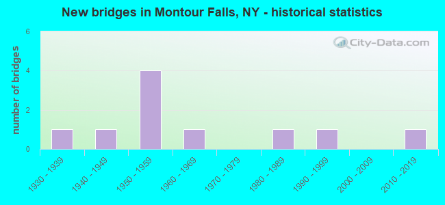
- New bridges - historical statistics
- 11930-1939
- 11940-1949
- 41950-1959
- 11960-1969
- 11980-1989
- 11990-1999
- 12010-2019

- Reconstructed bridges - Historical Statistics
- 11990-1999
- 22000-2009
- 32010-2019


- Bridge Condition - Deck
- 25.0%Excellent
- 25.0%Very good
- 25.0%Good
- 25.0%Satisfactory

- Bridge Condition - Superstructure
- 12.5%Excellent
- 25.0%Good
- 50.0%Satisfactory
- 12.5%Fair

- Bridge Condition - Substructure
- 12.5%Excellent
- 37.5%Good
- 37.5%Satisfactory
- 12.5%Fair

- Bridge Condition - Channel
- 10.0%Very good
- 50.0%Good
- 20.0%Satisfactory
- 20.0%Fair

- Bridge Condition - Culverts
- 50.0%Satisfactory
- 50.0%Fair
Find on map >> Show street view
Structure Number: 101087, Location: 1.0 MI S OF MONTOUR FALLS (Lat: 42.335903, Lng: -76.836728), Route carried "on" structure: State highway 14, Year Built: 1951, Year Reconstructed: 2008, Status: Open, Structure Length: 2.32m (7.61ft), Average Daily Traffic: 5,419 (year 2017), Truck Traffic: 12%, Average Future Daily Traffic: 5,470 (year 2040), Design Load: HS 25 or greater, Features Intersected: McClure Creek
Minimum Vertical Clearance: 30+ m (98+ ft), Kilometerpoint: 5.374, Lanes on structure: 2, Base Highway Network: Yes, Owner: State Highway Agency, Approaching Roadway Width: 12.2m (40.0ft), Material/Design: Steel, Design/Construction: Stringer/Multi-beam, Number Of Spans In Main Unit: 1, Length of Maximum Span: 22.0m (72.2ft), Curb-To-Curb Width: 12.2m (40.0ft), Out-to-Out Width: 13.1m (43.0ft)
Condition: Deck: Good, Superstructure: Good, Substructure: Good, Channel: Good, Operating Rating: 75.0 metric tons, Method Used To Determine Operating Rating: Load Factor (LF), Inventory Rating: 45.0 metric tons, Method Used To Determine Inventory Rating: Load Factor (LF), Structural Evaluation: Better than present minimum criteria, Deck Geometry: Somewhat better than minimum adequacy, Waterway Adequacy: Somewhat better than minimum adequacy, Approach Roadway Alignment: Equal to present desirable criteria, Length Of Structure Improvement: 2.31m (7.58ft), Designated Inspection Frequency: Every 24 months, Inspection Date: November 2020, Bridge Improvement Cost: $1,070,000, Roadway Improvement Cost: $627,000, Total Project Cost: $1,697,000 ( Estimate for 2021), Deck Structure Type: Concrete Cast-file-Place, Wearing Surface/Protective System: Wearing Surface: Integral Concrete, Deck Protection: Epoxy Coated Reinforcing
Find on map >> Show street view
Structure Number: 101088, Location: 0.9 MI S OF MONTOUR FALLS (Lat: 42.337906, Lng: -76.836972), Route carried "on" structure: State highway 14, Year Built: 1950, Year Reconstructed: 2008, Status: Open, Structure Length: 7.53m (24.70ft), Average Daily Traffic: 5,419 (year 2017), Truck Traffic: 12%, Average Future Daily Traffic: 5,470 (year 2040), Design Load: H 20, Features Intersected: Diversion Channel
Minimum Vertical Clearance: 30+ m (98+ ft), Kilometerpoint: 5.567, Lanes on structure: 2, Base Highway Network: Yes, Owner: State Highway Agency, Approaching Roadway Width: 12.2m (40.0ft), Material/Design: Steel, Design/Construction: Stringer/Multi-beam, Number Of Spans In Main Unit: 3, Length of Maximum Span: 24.4m (80.1ft), Curb-To-Curb Width: 12.2m (40.0ft), Out-to-Out Width: 13.1m (43.0ft)
Condition: Deck: Very good, Superstructure: Satisfactory, Substructure: Satisfactory, Channel: Good, Operating Rating: 65.0 metric tons, Method Used To Determine Operating Rating: Load Factor (LF), Inventory Rating: 39.0 metric tons, Method Used To Determine Inventory Rating: Load Factor (LF), Structural Evaluation: Equal to present minimum criteria, Deck Geometry: Somewhat better than minimum adequacy, Waterway Adequacy: Equal to present minimum criteria, Approach Roadway Alignment: Equal to present desirable criteria, Length Of Structure Improvement: 7.52m (24.67ft), Designated Inspection Frequency: Every 24 months, Inspection Date: November 2020, Bridge Improvement Cost: $2,875,000, Roadway Improvement Cost: $1,684,000, Total Project Cost: $4,559,000 ( Estimate for 2021), Deck Structure Type: Concrete Cast-file-Place, Wearing Surface/Protective System: Wearing Surface: Integral Concrete
Find on map >> Show street view
Structure Number: 101089, Location: 0.3 MI N OF MONTOUR FALLS (Lat: 42.350903, Lng: -76.849747), Route carried "on" structure: State highway 14, Year Built: 1981, Year Reconstructed: 2021, Status: Open, Structure Length: 4.75m (15.58ft), Average Daily Traffic: 8,067 (year 2020), Truck Traffic: 10%, Average Future Daily Traffic: 8,143 (year 2040), Design Load: HL 93, Features Intersected: CATHARINE CREEK
Minimum Vertical Clearance: 30+ m (98+ ft), Kilometerpoint: 7.482, Lanes on structure: 2, Base Highway Network: Yes, Owner: State Highway Agency, Approaching Roadway Width: 13.4m (44.0ft), Skew: 4 degrees, Material/Design: Steel continuous, Design/Construction: Stringer/Multi-beam, Number Of Spans In Main Unit: 2, Length of Maximum Span: 23.1m (75.8ft), Curb-To-Curb Width: 13.0m (42.7ft), Out-to-Out Width: 14.0m (45.9ft)
Condition: Deck: Very good, Superstructure: Good, Substructure: Good, Channel: Good, Operating Rating: 74.4 metric tons, Method Used To Determine Operating Rating: Load Factor (LF), Inventory Rating: 44.5 metric tons, Method Used To Determine Inventory Rating: Load Factor (LF), Structural Evaluation: Better than present minimum criteria, Deck Geometry: Somewhat better than minimum adequacy, Waterway Adequacy: Somewhat better than minimum adequacy, Approach Roadway Alignment: Superior to present desirable criteria, Length Of Structure Improvement: 4.75m (15.58ft), Designated Inspection Frequency: Every 24 months, Inspection Date: November 2021, Bridge Improvement Cost: $2,030,000, Roadway Improvement Cost: $1,189,000, Total Project Cost: $3,219,000 ( Estimate for 2021), Deck Structure Type: Concrete Cast-file-Place, Wearing Surface/Protective System: Wearing Surface: Integral Concrete, Deck Protection: Epoxy Coated Reinforcing
Find on map >> Show street view
Structure Number: 104201, Location: 0.3 MI SE JCT RTS 14 +224 (Lat: 42.349003, Lng: -76.839211), Route carried "on" structure: State highway 224, Year Built: 1950, Year Reconstructed: 2010, Status: Open, Structure Length: 7.83m (25.69ft), Average Daily Traffic: 3,941 (year 2018), Truck Traffic: 7%, Average Future Daily Traffic: 3,965 (year 2040), Design Load: HS 20, Features Intersected: Diversion Channel
Minimum Vertical Clearance: 30+ m (98+ ft), Kilometerpoint: 23.009, Lanes on structure: 2, Base Highway Network: Yes, Owner: State Highway Agency, Approaching Roadway Width: 10.7m (35.1ft), Skew: 1 degrees, Material/Design: Steel, Design/Construction: Stringer/Multi-beam, Number Of Spans In Main Unit: 3, Length of Maximum Span: 25.6m (84.0ft), Curb or Sidewalk Widths: Left: 0.0m, Right: 1.4m (4.6ft), Curb-To-Curb Width: 10.7m (35.1ft), Out-to-Out Width: 13.0m (42.7ft)
Condition: Deck: Good, Superstructure: Satisfactory, Substructure: Good, Channel: Good, Operating Rating: 75.3 metric tons, Method Used To Determine Operating Rating: Load Factor (LF), Inventory Rating: 44.5 metric tons, Method Used To Determine Inventory Rating: Load Factor (LF), Structural Evaluation: Equal to present minimum criteria, Deck Geometry: Somewhat better than minimum adequacy, Waterway Adequacy: Somewhat better than minimum adequacy, Approach Roadway Alignment: Equal to present desirable criteria, Length Of Structure Improvement: 7.83m (25.69ft), Designated Inspection Frequency: Every 24 months, Inspection Date: November 2020, Bridge Improvement Cost: $3,001,000, Roadway Improvement Cost: $1,757,000, Total Project Cost: $4,758,000 ( Estimate for 2021), Deck Structure Type: Concrete Cast-file-Place, Wearing Surface/Protective System: Wearing Surface: Integral Concrete, Deck Protection: Epoxy Coated Reinforcing
Find on map >> Show street view
Structure Number: 209083, Location: IN MONTOUR FALLS (Lat: 42.346042, Lng: -76.850986), Route carried "on" structure: Bypass County highway , Year Built: 1954, Status: Open, Structure Length: 1.62m (5.31ft), Average Daily Traffic: 1,657 (year 2020), Truck Traffic: 3%, Average Future Daily Traffic: 1,728 (year 2040), Design Load: HS 20, Features Intersected: SHEQUAGA CREEK, Facility Carried by Structure: N GENESEE STREET
Minimum Vertical Clearance: 30+ m (98+ ft), Kilometerpoint: 1.641, Lanes on structure: 4, Owner: State Agenciy, Approaching Roadway Width: 9.1m (29.9ft), Skew: 6 degrees, Material/Design: Concrete, Design/Construction: Culvert, Number Of Spans In Main Unit: 2, Length of Maximum Span: 7.6m (24.9ft), Curb or Sidewalk Widths: Left: 0.0m, Right: 1.5m (4.9ft)
Condition: Channel: Good, Culverts: Satisfactory, Operating Rating: 58.1 metric tons, Method Used To Determine Operating Rating: Load Factor (LF), Inventory Rating: 34.5 metric tons, Method Used To Determine Inventory Rating: Load Factor (LF), Structural Evaluation: Equal to present minimum criteria, Waterway Adequacy: Equal to present minimum criteria, Approach Roadway Alignment: Equal to present desirable criteria, Length Of Structure Improvement: 2.89m (9.48ft), Designated Inspection Frequency: Every 24 months, Inspection Date: August 2021, Bridge Improvement Cost: $601,000, Roadway Improvement Cost: $352,000, Total Project Cost: $953,000 ( Estimate for 2021)
Find on map >> Show street view
Structure Number: 225429, Location: IN MONTOUR FALLS (Lat: 42.356364, Lng: -76.852872), Route carried "on" structure: Other road , Year Built: 1960, Year Reconstructed: 2019, Status: Posted for load, Structure Length: 1.98m (6.50ft), Average Daily Traffic: 95 (year 2018), Truck Traffic: 8%, Average Future Daily Traffic: 133 (year 2038), Features Intersected: CATHARINE CREEK, Facility Carried by Structure: MARINA DRIVE
Minimum Vertical Clearance: 30+ m (98+ ft), Kilometerpoint: 0.724, Lanes on structure: 1, Owner: Town or Township Highway Agency, Approaching Roadway Width: 3.7m (12.1ft), Material/Design: Steel, Design/Construction: Stringer/Multi-beam, Number Of Spans In Main Unit: 3, Length of Maximum Span: 12.2m (40.0ft), Curb-To-Curb Width: 4.5m (14.8ft), Out-to-Out Width: 5.1m (16.7ft)
Condition: Deck: Satisfactory, Superstructure: Fair, Substructure: Satisfactory, Channel: Fair, Operating Rating: 9.1 metric tons, Method Used To Determine Operating Rating: Field evaluation and documented engineering judgment, Inventory Rating: 9.1 metric tons, Method Used To Determine Inventory Rating: Field evaluation and documented engineering judgment, Structural Evaluation: High priority of corrective action, Deck Geometry: Equal to present minimum criteria, Waterway Adequacy: Equal to present desirable criteria, Approach Roadway Alignment: Meets minimum limits, Bridge Posting: Required (Relationship of Operating Rating to Maximum Legal Load: > 39.9% below), Length Of Structure Improvement: 1.98m (6.50ft), Designated Inspection Frequency: Every 12 months, Critical Feature Inspection Frequency: Every 12 months, Inspection Date: May 2021, Critical Feature Inspection Date: May 2021, Bridge Improvement Cost: $264,000, Roadway Improvement Cost: $155,000, Total Project Cost: $419,000 ( Estimate for 2021), Deck Structure Type: Open Grating, Wearing Surface/Protective System: Wearing Surface: Other
Find on map >> Show street view
Structure Number: 226949, Location: VILLAGE OF MONTOUR FALLS (Lat: 42.356356, Lng: -76.840664), Route carried "on" structure: Other road , Year Built: 1997, Status: Open, Structure Length: 0.76m (2.49ft), Average Daily Traffic: 31 (year 2019), Truck Traffic: 5%, Average Future Daily Traffic: 43 (year 2039), Design Load: HS 25 or greater, Features Intersected: JOHNS CREEK, Facility Carried by Structure: N SENECA STREET
Minimum Vertical Clearance: 30+ m (98+ ft), Kilometerpoint: 0.434, Lanes on structure: 1, Owner: Town or Township Highway Agency, Approaching Roadway Width: 4.9m (16.1ft), Material/Design: Concrete, Design/Construction: Culvert, Number Of Spans In Main Unit: 1, Length of Maximum Span: 7.3m (24.0ft), Curb-To-Curb Width: 3.9m (12.8ft), Out-to-Out Width: 4.6m (15.1ft)
Condition: Channel: Fair, Culverts: Fair, Operating Rating: 54.1 metric tons, Method Used To Determine Operating Rating: Load and Resistance Factor Rating (LRFR) rating reported by rating factor(RF) method using HL-93 loadings, Inventory Rating: 41.8 metric tons, Method Used To Determine Inventory Rating: Load and Resistance Factor Rating (LRFR) rating reported by rating factor(RF) method using HL-93 loadings, Structural Evaluation: Somewhat better than minimum adequacy, Deck Geometry: Meets minimum limits, Waterway Adequacy: Somewhat better than minimum adequacy, Approach Roadway Alignment: Equal to present minimum criteria, Length Of Structure Improvement: 0.76m (2.49ft), Designated Inspection Frequency: Every 24 months, Inspection Date: April 2021, Bridge Improvement Cost: $100,000, Roadway Improvement Cost: $58,000, Total Project Cost: $158,000 ( Estimate for 2021), Wearing Surface/Protective System: Wearing Surface: Bituminous, Membrane: Other
Find on map >> Show street view
Structure Number: 333256, Location: IN MONTOUR FALLS (Lat: 42.343875, Lng: -76.833603), Route carried "on" structure: Other road , Year Built: 1937, Year Reconstructed: 1990, Status: Open, Structure Length: 1.19m (3.90ft), Average Daily Traffic: 429 (year 2018), Truck Traffic: 5%, Average Future Daily Traffic: 601 (year 2038), Features Intersected: DECKERTOWN CREEK, Facility Carried by Structure: S LHOMMEDIEU STR
Minimum Vertical Clearance: 30+ m (98+ ft), Kilometerpoint: 0.708, Lanes on structure: 2, Owner: County Highway Agency, Approaching Roadway Width: 6.1m (20.0ft), Material/Design: Steel, Design/Construction: Stringer/Multi-beam, Number Of Spans In Main Unit: 1, Length of Maximum Span: 10.9m (35.8ft), Curb-To-Curb Width: 6.3m (20.7ft), Out-to-Out Width: 6.9m (22.6ft)
Condition: Deck: Satisfactory, Superstructure: Satisfactory, Substructure: Fair, Channel: Satisfactory, Operating Rating: 52.6 metric tons, Method Used To Determine Operating Rating: Load Factor (LF), Inventory Rating: 30.8 metric tons, Method Used To Determine Inventory Rating: Load Factor (LF), Structural Evaluation: Somewhat better than minimum adequacy, Deck Geometry: High priority of corrective action, Waterway Adequacy: Equal to present desirable criteria, Approach Roadway Alignment: Equal to present minimum criteria, Length Of Structure Improvement: 1.18m (3.87ft), Designated Inspection Frequency: Every 24 months, Inspection Date: June 2020, Bridge Improvement Cost: $378,000, Roadway Improvement Cost: $221,000, Total Project Cost: $600,000 ( Estimate for 2021), Deck Structure Type: Wood or Timber, Wearing Surface/Protective System: Wearing Surface: Bituminous
Find on map >> Show street view
Structure Number: 333257, Location: IN MONTOUR FALLS (Lat: 42.355267, Lng: -76.836797), Route carried "on" structure: Other road , Year Built: 2018, Status: Open, Structure Length: 1.86m (6.10ft), Average Daily Traffic: 1,474 (year 2016), Truck Traffic: 3%, Average Future Daily Traffic: 2,064 (year 2036), Design Load: HL 93, Features Intersected: JOHNS CREEK, Facility Carried by Structure: N LHOMMEDIEU STR
Minimum Vertical Clearance: 30+ m (98+ ft), Kilometerpoint: 2.011, Lanes on structure: 2, Owner: County Highway Agency, Approaching Roadway Width: 8.5m (27.9ft), Skew: 1 degrees, Material/Design: Prestressed concrete, Design/Construction: Tee Beam, Number Of Spans In Main Unit: 1, Length of Maximum Span: 18.3m (60.0ft), Curb-To-Curb Width: 8.6m (28.2ft), Out-to-Out Width: 9.8m (32.2ft)
Condition: Deck: Excellent, Superstructure: Excellent, Substructure: Excellent, Channel: Very good, Operating Rating: 47.6 metric tons, Method Used To Determine Operating Rating: Load and Resistance Factor Rating (LRFR) rating reported by rating factor(RF) method using HL-93 loadings, Inventory Rating: 36.9 metric tons, Method Used To Determine Inventory Rating: Load and Resistance Factor Rating (LRFR) rating reported by rating factor(RF) method using HL-93 loadings, Structural Evaluation: Superior to present desirable criteria, Deck Geometry: Somewhat better than minimum adequacy, Waterway Adequacy: Equal to present desirable criteria, Approach Roadway Alignment: Equal to present minimum criteria, Length Of Structure Improvement: 1.85m (6.07ft), Designated Inspection Frequency: Every 24 months, Inspection Date: November 2020, Bridge Improvement Cost: $666,000, Roadway Improvement Cost: $390,000, Total Project Cost: $1,056,000 ( Estimate for 2021), Wearing Surface/Protective System: Wearing Surface: Bituminous, Membrane: Other
Find on map >> Show street view
Structure Number: 333258, Location: IN MONTOUR FALLS (Lat: 42.344922, Lng: -76.852100), Route carried "on" structure: Other road , Year Built: 1949, Year Reconstructed: 2019, Status: Open, Structure Length: 3.66m (12.01ft), Average Daily Traffic: 297 (year 2018), Truck Traffic: 4%, Average Future Daily Traffic: 416 (year 2038), Design Load: H 20, Features Intersected: CHEQUAGA FALLS, Facility Carried by Structure: MILL STREET
Minimum Vertical Clearance: 30+ m (98+ ft), Kilometerpoint: 0.370, Lanes on structure: 2, Owner: County Highway Agency, Approaching Roadway Width: 7.9m (25.9ft), Material/Design: Steel, Design/Construction: Arch - Deck, Number Of Spans In Main Unit: 1, Number Of Approach Spans: 2, Length of Maximum Span: 25.6m (84.0ft), Curb-To-Curb Width: 7.3m (24.0ft), Out-to-Out Width: 8.3m (27.2ft)
Condition: Deck: Excellent, Superstructure: Satisfactory, Substructure: Satisfactory, Channel: Satisfactory, Operating Rating: 58.1 metric tons, Method Used To Determine Operating Rating: Allowable Stress (AS), Inventory Rating: 39.9 metric tons, Method Used To Determine Inventory Rating: Allowable Stress (AS), Structural Evaluation: Equal to present minimum criteria, Deck Geometry: Somewhat better than minimum adequacy, Waterway Adequacy: Superior to present desirable criteria, Approach Roadway Alignment: Somewhat better than minimum adequacy, Length Of Structure Improvement: 3.65m (11.98ft), Designated Inspection Frequency: Every 24 months, Critical Feature Inspection Frequency: Every 24 months, Inspection Date: October 2021, Critical Feature Inspection Date: October 2021, Bridge Improvement Cost: $1,569,000, Roadway Improvement Cost: $919,000, Total Project Cost: $2,487,000 ( Estimate for 2021), Deck Structure Type: Concrete Cast-file-Place, Wearing Surface/Protective System: Wearing Surface: Integral Concrete, Deck Protection: Epoxy Coated Reinforcing