Bridge Statistics for Montrose, Colorado (CO)
Condition, Traffic, Stress, Structural Evaluation, Project Costs
- National Bridge Inventory (NBI) Statistics
- 35Number of bridges
- 223ft / 68.2mTotal length
- $3,140,000Total costs
- 120,104Total average daily traffic
- 7,382Total average daily truck traffic
- 150,669Total future (year 2037) average daily traffic
- National Bridge Inventory (NBI) Registered Bridges for Montrose
- No street view available for this location
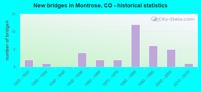
- New bridges - historical statistics
- 21920-1929
- 11930-1939
- 41950-1959
- 21960-1969
- 21970-1979
- 121980-1989
- 61990-1999
- 52000-2009
- 12010-2019
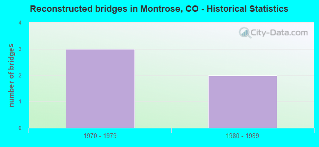
- Reconstructed bridges - Historical Statistics
- 31970-1979
- 21980-1989
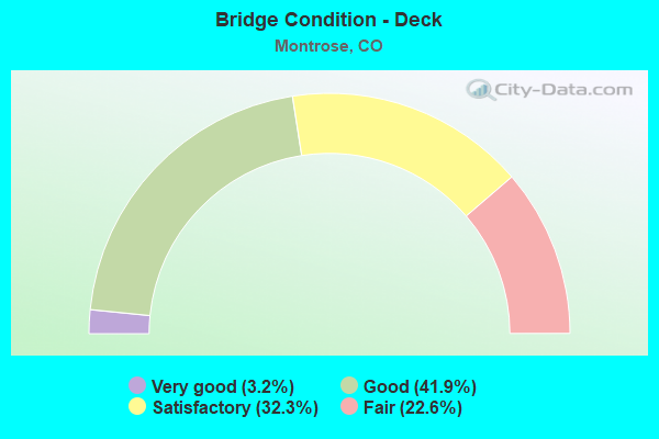
- Bridge Condition - Deck
- 3.2%Very good
- 41.9%Good
- 32.3%Satisfactory
- 22.6%Fair
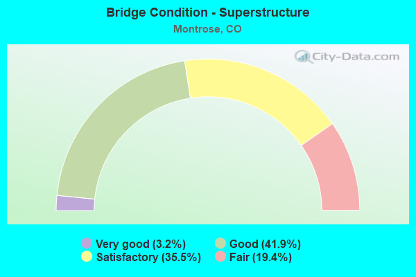
- Bridge Condition - Superstructure
- 3.2%Very good
- 41.9%Good
- 35.5%Satisfactory
- 19.4%Fair
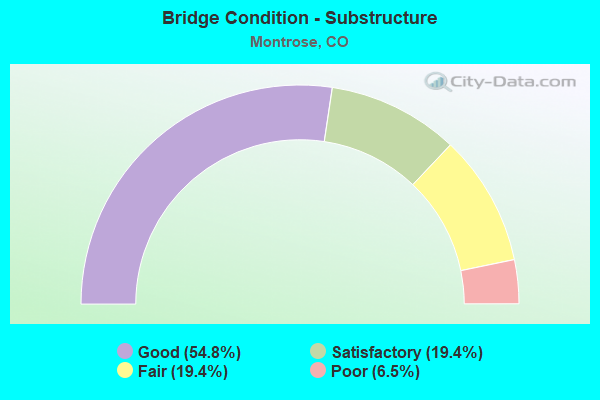
- Bridge Condition - Substructure
- 54.8%Good
- 19.4%Satisfactory
- 19.4%Fair
- 6.5%Poor
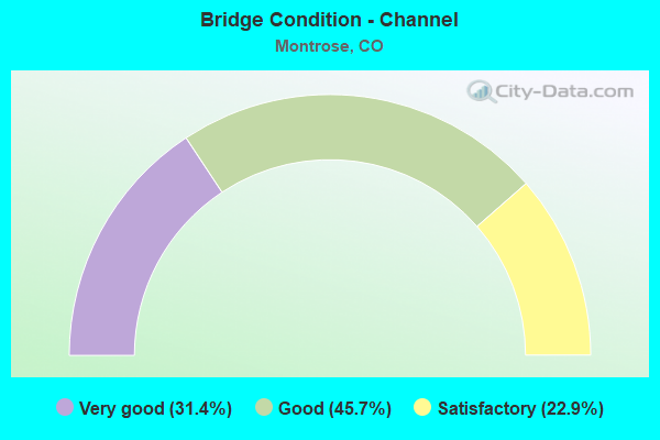
- Bridge Condition - Channel
- 31.4%Very good
- 45.7%Good
- 22.9%Satisfactory
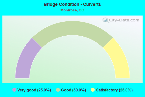
- Bridge Condition - Culverts
- 25.0%Very good
- 50.0%Good
- 25.0%Satisfactory
Find on map >> Show street view
Structure Number: 85000703.1021A, Location: JUST W OF SH 550 (Lat: 38.400367, Lng: -107.838600), Route carried "on" structure: County highway , Year Built: 1994, Status: Open, Structure Length: 1.66m (5.45ft), Average Daily Traffic: 122 (year 2017), Average Future Daily Traffic: 196 (year 2037), Design Load: HS 20, Features Intersected: MONTROSE AND DELTA CANAL, Facility Carried by Structure: COUNTY ROAD 7
Minimum Vertical Clearance: 30+ m (98+ ft), Kilometerpoint: 9.200, Lanes on structure: 2, Owner: County Highway Agency, Approaching Roadway Width: 8.2m (26.9ft), Skew: 5 degrees, Material/Design: Steel, Design/Construction: Stringer/Multi-beam, Number Of Spans In Main Unit: 1, Length of Maximum Span: 15.7m (51.5ft), Curb-To-Curb Width: 8.5m (27.9ft), Out-to-Out Width: 8.7m (28.5ft)
Condition: Deck: Good, Superstructure: Good, Substructure: Good, Channel: Very good, Operating Rating: 55.1 metric tons, Method Used To Determine Operating Rating: Load Factor (LF), Inventory Rating: 33.0 metric tons, Method Used To Determine Inventory Rating: Load Factor (LF), Structural Evaluation: Better than present minimum criteria, Deck Geometry: Equal to present minimum criteria, Waterway Adequacy: Equal to present desirable criteria, Approach Roadway Alignment: Equal to present desirable criteria, Designated Inspection Frequency: Every 24 months, Inspection Date: November 2021, Deck Structure Type: Corrugated Steel, Wearing Surface/Protective System: Wearing Surface: Bituminous
Find on map >> Show street view
Structure Number: 85002200.4053A, Location: 4.8 MI NW OF MONTROSE (Lat: 38.533150, Lng: -107.933217), Route carried "on" structure: County highway , Year Built: 1989, Status: Open, Structure Length: 1.23m (4.04ft), Average Daily Traffic: 578 (year 2018), Truck Traffic: 2%, Average Future Daily Traffic: 931 (year 2038), Design Load: HS 20, Features Intersected: SELIG CANAL, Facility Carried by Structure: JAY JAY ROAD
Minimum Vertical Clearance: 30+ m (98+ ft), Kilometerpoint: 0.587, Lanes on structure: 2, Owner: County Highway Agency, Approaching Roadway Width: 9.1m (29.9ft), Skew: 3 degrees, Material/Design: Steel, Design/Construction: Stringer/Multi-beam, Number Of Spans In Main Unit: 1, Length of Maximum Span: 11.6m (38.1ft), Curb-To-Curb Width: 8.5m (27.9ft), Out-to-Out Width: 8.5m (27.9ft)
Condition: Deck: Satisfactory, Superstructure: Good, Substructure: Good, Channel: Satisfactory, Operating Rating: 53.3 metric tons, Method Used To Determine Operating Rating: Load Factor (LF), Inventory Rating: 31.9 metric tons, Method Used To Determine Inventory Rating: Load Factor (LF), Structural Evaluation: Better than present minimum criteria, Deck Geometry: Somewhat better than minimum adequacy, Waterway Adequacy: Equal to present desirable criteria, Approach Roadway Alignment: Better than present minimum criteria, Designated Inspection Frequency: Every 24 months, Inspection Date: October 2021, Deck Structure Type: Corrugated Steel, Wearing Surface/Protective System: Wearing Surface: Bituminous
Find on map >> Show street view
Structure Number: 85003001.4054A, Location: 6 MI NW OF MONTROSE (Lat: 38.532883, Lng: -107.963092), Route carried "on" structure: County highway , Year Built: 1983, Status: Open, Structure Length: 2.75m (9.02ft), Average Daily Traffic: 1,645 (year 2018), Truck Traffic: 2%, Average Future Daily Traffic: 2,648 (year 2038), Design Load: HS 20, Features Intersected: UNCOMPAHGRE RIVER, Facility Carried by Structure: JAY JAY ROAD
Minimum Vertical Clearance: 30+ m (98+ ft), Kilometerpoint: 0.402, Lanes on structure: 2, Owner: County Highway Agency, Approaching Roadway Width: 9.1m (29.9ft), Material/Design: Prestressed concrete, Design/Construction: Stringer/Multi-beam, Number Of Spans In Main Unit: 1, Length of Maximum Span: 25.9m (85.0ft), Curb-To-Curb Width: 9.7m (31.8ft), Out-to-Out Width: 10.5m (34.4ft)
Condition: Deck: Satisfactory, Superstructure: Very good, Substructure: Good, Channel: Good, Operating Rating: 36.3 metric tons, Method Used To Determine Operating Rating: Field evaluation and documented engineering judgment, Inventory Rating: 32.7 metric tons, Method Used To Determine Inventory Rating: Field evaluation and documented engineering judgment, Structural Evaluation: Better than present minimum criteria, Deck Geometry: Somewhat better than minimum adequacy, Waterway Adequacy: Equal to present desirable criteria, Approach Roadway Alignment: Equal to present minimum criteria, Designated Inspection Frequency: Every 24 months, Inspection Date: October 2021, Deck Structure Type: Other, Wearing Surface/Protective System: Wearing Surface: Monolithic Concrete
Find on map >> Show street view
Structure Number: 85003001.5055A, Location: 6.1 MI NW OF MONTROSE (Lat: 38.533500, Lng: -107.965056), Route carried "on" structure: County highway , Year Built: 1923, Year Reconstructed: 1981, Status: Open, Structure Length: 0.95m (3.12ft), Average Daily Traffic: 2,346 (year 2018), Truck Traffic: 2%, Average Future Daily Traffic: 3,778 (year 2038), Features Intersected: SPRING CREEK, Facility Carried by Structure: JAY JAY ROAD
Minimum Vertical Clearance: 30+ m (98+ ft), Kilometerpoint: 0.216, Lanes on structure: 2, Owner: County Highway Agency, Approaching Roadway Width: 7.9m (25.9ft), Material/Design: Concrete, Design/Construction: Tee Beam, Number Of Spans In Main Unit: 1, Length of Maximum Span: 8.6m (28.2ft), Curb or Sidewalk Widths: Left: 0.2m (0.7ft), Right: 0.0m, Curb-To-Curb Width: 8.8m (28.9ft), Out-to-Out Width: 9.3m (30.5ft)
Condition: Deck: Fair, Superstructure: Fair, Substructure: Fair, Channel: Satisfactory, Operating Rating: 34.4 metric tons, Method Used To Determine Operating Rating: Load Factor (LF), Inventory Rating: 20.6 metric tons, Method Used To Determine Inventory Rating: Load Factor (LF), Structural Evaluation: Somewhat better than minimum adequacy, Deck Geometry: Meets minimum limits, Waterway Adequacy: Somewhat better than minimum adequacy, Approach Roadway Alignment: Equal to present minimum criteria, Designated Inspection Frequency: Every 24 months, Inspection Date: October 2021, Deck Structure Type: Concrete Cast-file-Place, Wearing Surface/Protective System: Wearing Surface: Bituminous
Find on map >> Show street view
Structure Number: 85003200.4048A, Location: .5 MI W OF SH 50 (Lat: 38.503733, Lng: -107.911628), Route carried "on" structure: County highway , Year Built: 1991, Status: Open, Structure Length: 2.24m (7.35ft), Average Daily Traffic: 3,608 (year 2018), Truck Traffic: 5%, Average Future Daily Traffic: 5,808 (year 2038), Features Intersected: UNCOMPAHGRE RIVER, Facility Carried by Structure: LA SALLE ROAD
Minimum Vertical Clearance: 30+ m (98+ ft), Kilometerpoint: 5.491, Lanes on structure: 2, Owner: County Highway Agency, Approaching Roadway Width: 8.5m (27.9ft), Material/Design: Steel, Design/Construction: Stringer/Multi-beam, Number Of Spans In Main Unit: 1, Length of Maximum Span: 21.1m (69.2ft), Curb-To-Curb Width: 8.7m (28.5ft), Out-to-Out Width: 8.8m (28.9ft)
Condition: Deck: Good, Superstructure: Satisfactory, Substructure: Good, Channel: Good, Operating Rating: 45.1 metric tons, Method Used To Determine Operating Rating: Load Factor (LF), Inventory Rating: 27.0 metric tons, Method Used To Determine Inventory Rating: Load Factor (LF), Structural Evaluation: Equal to present minimum criteria, Deck Geometry: Meets minimum limits, Waterway Adequacy: Equal to present desirable criteria, Approach Roadway Alignment: Equal to present desirable criteria, Designated Inspection Frequency: Every 24 months, Inspection Date: October 2021, Deck Structure Type: Concrete Cast-file-Place, Wearing Surface/Protective System: Wearing Surface: Bituminous
Find on map >> Show street view
Structure Number: 85003602.4040A, Location: .5 MI E OF CR 60.00 (Lat: 38.460225, Lng: -107.957378), Route carried "on" structure: County highway , Year Built: 1988, Status: Open, Structure Length: 0.99m (3.25ft), Average Daily Traffic: 403 (year 2018), Truck Traffic: 2%, Average Future Daily Traffic: 648 (year 2038), Features Intersected: MONTROSE AND DELTA CANAL, Facility Carried by Structure: OAK GROVE RD
Minimum Vertical Clearance: 30+ m (98+ ft), Kilometerpoint: 0.867, Lanes on structure: 2, Owner: County Highway Agency, Approaching Roadway Width: 7.0m (23.0ft), Skew: 1 degrees, Material/Design: Steel, Design/Construction: Stringer/Multi-beam, Number Of Spans In Main Unit: 1, Length of Maximum Span: 9.5m (31.2ft), Curb-To-Curb Width: 8.5m (27.9ft), Out-to-Out Width: 8.5m (27.9ft)
Condition: Deck: Fair, Superstructure: Fair, Substructure: Fair, Channel: Good, Operating Rating: 46.4 metric tons, Method Used To Determine Operating Rating: Load Factor (LF), Inventory Rating: 27.9 metric tons, Method Used To Determine Inventory Rating: Load Factor (LF), Structural Evaluation: Somewhat better than minimum adequacy, Deck Geometry: Somewhat better than minimum adequacy, Waterway Adequacy: Equal to present desirable criteria, Approach Roadway Alignment: Better than present minimum criteria, Designated Inspection Frequency: Every 24 months, Inspection Date: November 2021, Deck Structure Type: Corrugated Steel, Wearing Surface/Protective System: Wearing Surface: Bituminous
Find on map >> Show street view
Structure Number: 85004301.20044, Location: 1.2 MI SE OF SH 90 (Lat: 38.439389, Lng: -107.909492), Route carried "on" structure: County highway , Year Built: 1950, Year Reconstructed: 1987, Status: Open, Structure Length: 0.90m (2.95ft), Average Daily Traffic: 706 (year 2017), Truck Traffic: 2%, Average Future Daily Traffic: 1,137 (year 2037), Features Intersected: MONTROSE AND DELTA CANAL, Facility Carried by Structure: COUNTY ROAD 6300
Minimum Vertical Clearance: 30+ m (98+ ft), Kilometerpoint: 0.754, Lanes on structure: 2, Owner: County Highway Agency, Approaching Roadway Width: 7.3m (24.0ft), Skew: 1 degrees, Material/Design: Steel, Design/Construction: Stringer/Multi-beam, Number Of Spans In Main Unit: 1, Length of Maximum Span: 8.4m (27.6ft), Curb-To-Curb Width: 7.3m (24.0ft), Out-to-Out Width: 7.4m (24.3ft)
Condition: Deck: Fair, Superstructure: Satisfactory, Substructure: Poor, Channel: Good, Operating Rating: 42.7 metric tons, Method Used To Determine Operating Rating: Load Factor (LF), Inventory Rating: 25.6 metric tons, Method Used To Determine Inventory Rating: Load Factor (LF), Structural Evaluation: Meets minimum limits, Deck Geometry: Meets minimum limits, Waterway Adequacy: Equal to present desirable criteria, Approach Roadway Alignment: Equal to present desirable criteria, Designated Inspection Frequency: Every 24 months, Inspection Date: November 2021, Deck Structure Type: Corrugated Steel, Wearing Surface/Protective System: Wearing Surface: Bituminous
Find on map >> Show street view
Structure Number: 85004401.30043, Location: 1.1 MI S OF SH 90 (Lat: 38.441094, Lng: -107.918794), Route carried "on" structure: County highway , Year Built: 1925, Year Reconstructed: 1987, Status: Open, Structure Length: 1.26m (4.13ft), Average Daily Traffic: 633 (year 2017), Truck Traffic: 2%, Average Future Daily Traffic: 1,019 (year 2037), Features Intersected: MONTROSE AND DELTA CANAL, Facility Carried by Structure: COUNTY ROAD 6250
Minimum Vertical Clearance: 30+ m (98+ ft), Kilometerpoint: 2.123, Lanes on structure: 2, Owner: County Highway Agency, Approaching Roadway Width: 7.3m (24.0ft), Skew: 3 degrees, Material/Design: Steel, Design/Construction: Stringer/Multi-beam, Number Of Spans In Main Unit: 1, Length of Maximum Span: 11.6m (38.1ft), Curb-To-Curb Width: 7.3m (24.0ft), Out-to-Out Width: 7.3m (24.0ft)
Condition: Deck: Satisfactory, Superstructure: Fair, Substructure: Satisfactory, Channel: Good, Operating Rating: 45.1 metric tons, Method Used To Determine Operating Rating: Load Factor (LF), Inventory Rating: 27.0 metric tons, Method Used To Determine Inventory Rating: Load Factor (LF), Structural Evaluation: Somewhat better than minimum adequacy, Deck Geometry: Meets minimum limits, Waterway Adequacy: Equal to present desirable criteria, Approach Roadway Alignment: Better than present minimum criteria, Designated Inspection Frequency: Every 24 months, Inspection Date: November 2021, Deck Structure Type: Corrugated Steel, Wearing Surface/Protective System: Wearing Surface: Bituminous
Find on map >> Show street view
Structure Number: 85006700.4020A, Location: 0.25 M E OF SH 550 (Lat: 38.391950, Lng: -107.823867), Route carried "on" structure: County highway , Year Built: 1989, Status: Open, Structure Length: 2.28m (7.48ft), Average Daily Traffic: 246 (year 2017), Truck Traffic: 2%, Average Future Daily Traffic: 396 (year 2037), Features Intersected: UNCOMPAHGRE RIVER, Facility Carried by Structure: TROUT ROAD
Minimum Vertical Clearance: 30+ m (98+ ft), Kilometerpoint: 0.666, Lanes on structure: 2, Owner: County Highway Agency, Approaching Roadway Width: 8.2m (26.9ft), Material/Design: Prestressed concrete, Design/Construction: Tee Beam, Number Of Spans In Main Unit: 1, Length of Maximum Span: 21.9m (71.9ft), Curb-To-Curb Width: 9.1m (29.9ft), Out-to-Out Width: 10.1m (33.1ft)
Condition: Deck: Good, Superstructure: Good, Substructure: Good, Channel: Satisfactory, Operating Rating: 36.3 metric tons, Method Used To Determine Operating Rating: Field evaluation and documented engineering judgment, Inventory Rating: 32.7 metric tons, Method Used To Determine Inventory Rating: Field evaluation and documented engineering judgment, Structural Evaluation: Better than present minimum criteria, Deck Geometry: Equal to present minimum criteria, Waterway Adequacy: Equal to present desirable criteria, Approach Roadway Alignment: Somewhat better than minimum adequacy, Designated Inspection Frequency: Every 24 months, Inspection Date: November 2021, Deck Structure Type: Other, Wearing Surface/Protective System: Wearing Surface: Bituminous
Find on map >> Show street view
Structure Number: 85006805.8019A, Location: AT CANAL ROAD (Lat: 38.410886, Lng: -107.794908), Route carried "on" structure: County highway , Year Built: 1986, Status: Open, Structure Length: 1.97m (6.46ft), Average Daily Traffic: 195 (year 2017), Truck Traffic: 2%, Average Future Daily Traffic: 315 (year 2037), Features Intersected: SOUTH CANAL, Facility Carried by Structure: KINIKIN RD
Minimum Vertical Clearance: 30+ m (98+ ft), Kilometerpoint: 5.774, Lanes on structure: 2, Owner: County Highway Agency, Approaching Roadway Width: 6.4m (21.0ft), Material/Design: Steel, Design/Construction: Stringer/Multi-beam, Number Of Spans In Main Unit: 1, Length of Maximum Span: 19.0m (62.3ft), Curb-To-Curb Width: 8.6m (28.2ft), Out-to-Out Width: 8.6m (28.2ft)
Condition: Deck: Fair, Superstructure: Satisfactory, Substructure: Fair, Channel: Good, Operating Rating: 30.5 metric tons, Method Used To Determine Operating Rating: Load Factor (LF), Inventory Rating: 18.2 metric tons, Method Used To Determine Inventory Rating: Load Factor (LF), Structural Evaluation: Somewhat better than minimum adequacy, Deck Geometry: Equal to present minimum criteria, Waterway Adequacy: Equal to present desirable criteria, Approach Roadway Alignment: Better than present minimum criteria, Designated Inspection Frequency: Every 24 months, Inspection Date: November 2021, Deck Structure Type: Corrugated Steel, Wearing Surface/Protective System: Wearing Surface: Bituminous
Find on map >> Show street view
Structure Number: 85034B00.40047, Location: .4 MI W OF CR 61 (Lat: 38.489244, Lng: -107.956431), Route carried "on" structure: County highway , Year Built: 1980, Status: Open, Structure Length: 0.70m (2.30ft), Average Daily Traffic: 354 (year 2018), Truck Traffic: 2%, Average Future Daily Traffic: 570 (year 2038), Design Load: HS 20+Mod, Features Intersected: SPRING CREEK, Facility Carried by Structure: MAPLE GROVE ROAD
Minimum Vertical Clearance: 30+ m (98+ ft), Kilometerpoint: 3.030, Lanes on structure: 2, Owner: County Highway Agency, Approaching Roadway Width: 7.6m (24.9ft), Material/Design: Aluminum, Iron, Design/Construction: Culvert, Number Of Spans In Main Unit: 1, Length of Maximum Span: 7.0m (23.0ft), Out-to-Out Width: 9.8m (32.2ft)
Condition: Channel: Good, Culverts: Satisfactory, Operating Rating: 74.9 metric tons, Method Used To Determine Operating Rating: Load Factor (LF), Inventory Rating: 44.9 metric tons, Method Used To Determine Inventory Rating: Load Factor (LF), Structural Evaluation: Equal to present minimum criteria, Waterway Adequacy: Better than present minimum criteria, Approach Roadway Alignment: Equal to present desirable criteria, Designated Inspection Frequency: Every 24 months, Inspection Date: October 2021
Find on map >> Show street view
Structure Number: 85035B00.6041A, Location: .5 MI S OF OAK GROVE (Lat: 38.451261, Lng: -107.946658), Route carried "on" structure: County highway , Year Built: 1987, Status: Open, Structure Length: 0.93m (3.05ft), Average Daily Traffic: 194 (year 2018), Truck Traffic: 2%, Average Future Daily Traffic: 313 (year 2038), Features Intersected: MONTROSE AND DELTA CANAL, Facility Carried by Structure: COUNTY ROAD 6100
Minimum Vertical Clearance: 30+ m (98+ ft), Kilometerpoint: 0.966, Lanes on structure: 2, Owner: County Highway Agency, Approaching Roadway Width: 7.3m (24.0ft), Skew: 2 degrees, Material/Design: Steel, Design/Construction: Stringer/Multi-beam, Number Of Spans In Main Unit: 1, Length of Maximum Span: 8.8m (28.9ft), Curb-To-Curb Width: 8.5m (27.9ft), Out-to-Out Width: 8.5m (27.9ft)
Condition: Deck: Fair, Superstructure: Fair, Substructure: Fair, Channel: Good, Operating Rating: 54.3 metric tons, Method Used To Determine Operating Rating: Load Factor (LF), Inventory Rating: 32.6 metric tons, Method Used To Determine Inventory Rating: Load Factor (LF), Structural Evaluation: Somewhat better than minimum adequacy, Deck Geometry: Equal to present minimum criteria, Waterway Adequacy: Equal to present desirable criteria, Approach Roadway Alignment: Equal to present desirable criteria, Designated Inspection Frequency: Every 24 months, Inspection Date: November 2021, Deck Structure Type: Corrugated Steel, Wearing Surface/Protective System: Wearing Surface: Gravel
Find on map >> Show street view
Structure Number: 8503701.30049A, Location: .4 MI N OF FLAT TOP RD (Lat: 38.532578, Lng: -107.868400), Route carried "on" structure: County highway , Year Built: 2009, Status: Open, Structure Length: 2.04m (6.69ft), Average Daily Traffic: 69 (year 2018), Truck Traffic: 2%, Average Future Daily Traffic: 112 (year 2038), Design Load: HS 25 or greater, Features Intersected: LOUTSENHIZER CANAL, Facility Carried by Structure: COUNTY ROAD 6530
Minimum Vertical Clearance: 30+ m (98+ ft), Kilometerpoint: 2.913, Lanes on structure: 1, Owner: County Highway Agency, Approaching Roadway Width: 5.9m (19.4ft), Material/Design: Steel, Design/Construction: Stringer/Multi-beam, Number Of Spans In Main Unit: 1, Length of Maximum Span: 19.2m (63.0ft), Curb-To-Curb Width: 4.3m (14.1ft), Out-to-Out Width: 4.3m (14.1ft)
Condition: Deck: Good, Superstructure: Good, Substructure: Good, Channel: Good, Operating Rating: 70.7 metric tons, Method Used To Determine Operating Rating: Load Factor (LF), Inventory Rating: 42.4 metric tons, Method Used To Determine Inventory Rating: Load Factor (LF), Structural Evaluation: Better than present minimum criteria, Deck Geometry: Equal to present minimum criteria, Waterway Adequacy: Equal to present desirable criteria, Approach Roadway Alignment: Equal to present desirable criteria, Designated Inspection Frequency: Every 24 months, Inspection Date: October 2021, Deck Structure Type: Corrugated Steel, Wearing Surface/Protective System: Wearing Surface: Bituminous
Find on map >> Show street view
Structure Number: 85041A01.6024A, Location: 1.8 W OF US 550 (Lat: 38.411222, Lng: -107.873353), Route carried "on" structure: County highway , Year Built: 1985, Status: Open, Structure Length: 1.23m (4.04ft), Average Daily Traffic: 124 (year 2017), Truck Traffic: 2%, Average Future Daily Traffic: 200 (year 2037), Features Intersected: MONTROSE AND DELTA CANAL, Facility Carried by Structure: COUNTY ROAD 6500
Minimum Vertical Clearance: 30+ m (98+ ft), Kilometerpoint: 4.159, Lanes on structure: 2, Owner: County Highway Agency, Approaching Roadway Width: 7.9m (25.9ft), Material/Design: Steel, Design/Construction: Stringer/Multi-beam, Number Of Spans In Main Unit: 1, Length of Maximum Span: 11.8m (38.7ft), Curb-To-Curb Width: 9.2m (30.2ft), Out-to-Out Width: 9.2m (30.2ft)
Condition: Deck: Fair, Superstructure: Fair, Substructure: Poor, Channel: Good, Operating Rating: 36.0 metric tons, Method Used To Determine Operating Rating: Load Factor (LF), Inventory Rating: 21.6 metric tons, Method Used To Determine Inventory Rating: Load Factor (LF), Structural Evaluation: Meets minimum limits, Deck Geometry: Equal to present minimum criteria, Waterway Adequacy: Equal to present desirable criteria, Approach Roadway Alignment: High priority of corrective action, Designated Inspection Frequency: Every 24 months, Inspection Date: November 2021, Deck Structure Type: Corrugated Steel, Wearing Surface/Protective System: Wearing Surface: Bituminous
Find on map >> Show street view
Structure Number: 85041A02.6046A, Location: 2 MI W OF US 550 (Lat: 38.421142, Lng: -107.890633), Route carried "on" structure: County highway , Year Built: 1983, Status: Open, Structure Length: 1.09m (3.58ft), Average Daily Traffic: 283 (year 2017), Truck Traffic: 2%, Average Future Daily Traffic: 455 (year 2037), Features Intersected: MONTROSE AND DELTA CANAL, Facility Carried by Structure: CR 6400/RANGER RD
Minimum Vertical Clearance: 30+ m (98+ ft), Kilometerpoint: 1.650, Lanes on structure: 2, Owner: County Highway Agency, Approaching Roadway Width: 6.7m (22.0ft), Material/Design: Steel continuous, Design/Construction: Stringer/Multi-beam, Number Of Spans In Main Unit: 2, Length of Maximum Span: 6.4m (21.0ft), Curb-To-Curb Width: 7.4m (24.3ft), Out-to-Out Width: 7.4m (24.3ft)
Condition: Deck: Satisfactory, Superstructure: Satisfactory, Substructure: Fair, Channel: Satisfactory, Operating Rating: 59.0 metric tons, Method Used To Determine Operating Rating: Load Factor (LF), Inventory Rating: 35.4 metric tons, Method Used To Determine Inventory Rating: Load Factor (LF), Structural Evaluation: Somewhat better than minimum adequacy, Deck Geometry: Somewhat better than minimum adequacy, Waterway Adequacy: Equal to present desirable criteria, Approach Roadway Alignment: Better than present minimum criteria, Designated Inspection Frequency: Every 24 months, Inspection Date: November 2021, Deck Structure Type: Corrugated Steel, Wearing Surface/Protective System: Wearing Surface: Bituminous
Find on map >> Show street view
Structure Number: 85041A02.90045, Location: 2 MI OF US 550 (Lat: 38.425800, Lng: -107.891303), Route carried "on" structure: County highway , Year Built: 1971, Status: Posted for load-capacity, Structure Length: 0.75m (2.46ft), Average Daily Traffic: 287 (year 2017), Truck Traffic: 2%, Average Future Daily Traffic: 462 (year 2037), Features Intersected: HAPPY CANYON CREEK, Facility Carried by Structure: COUNTY ROAD 6400
Minimum Vertical Clearance: 30+ m (98+ ft), Kilometerpoint: 0.333, Lanes on structure: 2, Owner: County Highway Agency, Approaching Roadway Width: 7.3m (24.0ft), Skew: 4 degrees, Material/Design: Steel, Design/Construction: Stringer/Multi-beam, Number Of Spans In Main Unit: 1, Length of Maximum Span: 6.8m (22.3ft), Curb-To-Curb Width: 7.2m (23.6ft), Out-to-Out Width: 7.4m (24.3ft)
Condition: Deck: Satisfactory, Superstructure: Satisfactory, Substructure: Satisfactory, Channel: Good, Operating Rating: 13.8 metric tons, Method Used To Determine Operating Rating: Load Factor (LF), Inventory Rating: 8.3 metric tons, Method Used To Determine Inventory Rating: Load Factor (LF), Structural Evaluation: High priority of replacement, Deck Geometry: Meets minimum limits, Waterway Adequacy: Equal to present desirable criteria, Approach Roadway Alignment: Somewhat better than minimum adequacy, Bridge Posting: Required (Relationship of Operating Rating to Maximum Legal Load: 30.0 - 39.9% below), Length Of Structure Improvement: 1.40m (4.59ft), Designated Inspection Frequency: Every 24 months, Inspection Date: October 2021, Bridge Improvement Cost: $845,000, Roadway Improvement Cost: $84,000, Total Project Cost: $929,000 ( Estimate for 2019), Deck Structure Type: Corrugated Steel, Wearing Surface/Protective System: Wearing Surface: Bituminous
Find on map >> Show street view
Structure Number: 85041B00.3023A, Location: 4.2 MI SE OF MONTROSE (Lat: 38.422875, Lng: -107.853589), Route carried "on" structure: County highway , Year Built: 1988, Status: Open, Structure Length: 3.66m (12.01ft), Average Daily Traffic: 323 (year 2017), Truck Traffic: 2%, Average Future Daily Traffic: 521 (year 2037), Design Load: HS 20, Features Intersected: UNCOMPAHGRE RIVER, Facility Carried by Structure: WOODGATE ROAD
Minimum Vertical Clearance: 30+ m (98+ ft), Kilometerpoint: 0.470, Lanes on structure: 2, Owner: County Highway Agency, Approaching Roadway Width: 7.3m (24.0ft), Material/Design: Prestressed concrete, Design/Construction: Stringer/Multi-beam, Number Of Spans In Main Unit: 1, Length of Maximum Span: 35.1m (115.2ft), Curb-To-Curb Width: 8.5m (27.9ft), Out-to-Out Width: 9.3m (30.5ft)
Condition: Deck: Good, Superstructure: Good, Substructure: Good, Channel: Very good, Operating Rating: 72.8 metric tons, Method Used To Determine Operating Rating: Load Factor (LF), Inventory Rating: 43.6 metric tons, Method Used To Determine Inventory Rating: Load Factor (LF), Structural Evaluation: Better than present minimum criteria, Deck Geometry: Equal to present minimum criteria, Waterway Adequacy: Equal to present desirable criteria, Approach Roadway Alignment: Equal to present minimum criteria, Designated Inspection Frequency: Every 24 months, Inspection Date: October 2021, Deck Structure Type: Concrete Cast-file-Place, Wearing Surface/Protective System: Wearing Surface: Bituminous, Deck Protection: Epoxy Coated Reinforcing
Find on map >> Show street view
Structure Number: 85056B01.2042A, Location: .9 MI SE OF SH 90 (Lat: 38.425428, Lng: -107.934200), Route carried "on" structure: County highway , Year Built: 1988, Status: Open, Structure Length: 0.93m (3.05ft), Average Daily Traffic: 223 (year 2017), Truck Traffic: 2%, Average Future Daily Traffic: 358 (year 2037), Features Intersected: SPRING CREEK, Facility Carried by Structure: POPULAR ROAD
Minimum Vertical Clearance: 30+ m (98+ ft), Kilometerpoint: 1.954, Lanes on structure: 2, Owner: County Highway Agency, Approaching Roadway Width: 7.0m (23.0ft), Skew: 4 degrees, Material/Design: Steel, Design/Construction: Stringer/Multi-beam, Number Of Spans In Main Unit: 1, Length of Maximum Span: 8.7m (28.5ft), Curb-To-Curb Width: 7.3m (24.0ft), Out-to-Out Width: 7.3m (24.0ft)
Condition: Deck: Satisfactory, Superstructure: Satisfactory, Substructure: Satisfactory, Channel: Satisfactory, Operating Rating: 26.9 metric tons, Method Used To Determine Operating Rating: Load Factor (LF), Inventory Rating: 16.1 metric tons, Method Used To Determine Inventory Rating: Load Factor (LF), Structural Evaluation: Meets minimum limits, Deck Geometry: Somewhat better than minimum adequacy, Waterway Adequacy: Equal to present desirable criteria, Approach Roadway Alignment: Equal to present desirable criteria, Designated Inspection Frequency: Every 24 months, Inspection Date: October 2021, Deck Structure Type: Corrugated Steel, Wearing Surface/Protective System: Wearing Surface: Gravel
Find on map >> Show street view
Structure Number: 85062B00.8022A, Location: 1 M W OF US 550 (Lat: 38.406597, Lng: -107.858942), Route carried "on" structure: County highway , Year Built: 1992, Status: Open, Structure Length: 1.30m (4.27ft), Average Daily Traffic: 482 (year 2017), Truck Traffic: 2%, Average Future Daily Traffic: 776 (year 2037), Design Load: HS 20, Features Intersected: MONTROSE AND DELTA CANAL, Facility Carried by Structure: SOLAR ROAD
Minimum Vertical Clearance: 30+ m (98+ ft), Kilometerpoint: 3.270, Lanes on structure: 2, Owner: County Highway Agency, Approaching Roadway Width: 7.9m (25.9ft), Material/Design: Steel, Design/Construction: Stringer/Multi-beam, Number Of Spans In Main Unit: 1, Length of Maximum Span: 12.1m (39.7ft), Curb-To-Curb Width: 8.5m (27.9ft), Out-to-Out Width: 8.7m (28.5ft)
Condition: Deck: Satisfactory, Superstructure: Satisfactory, Substructure: Satisfactory, Channel: Very good, Operating Rating: 48.8 metric tons, Method Used To Determine Operating Rating: Load Factor (LF), Inventory Rating: 29.2 metric tons, Method Used To Determine Inventory Rating: Load Factor (LF), Structural Evaluation: Equal to present minimum criteria, Deck Geometry: Somewhat better than minimum adequacy, Waterway Adequacy: Equal to present desirable criteria, Approach Roadway Alignment: Equal to present minimum criteria, Designated Inspection Frequency: Every 24 months, Inspection Date: November 2021, Deck Structure Type: Corrugated Steel, Wearing Surface/Protective System: Wearing Surface: Bituminous
Find on map >> Show street view
Structure Number: 85070B00.40018, Location: 0.3 MI E OF US550 (Lat: 38.377875, Lng: -107.810442), Route carried "on" structure: County highway , Year Built: 1960, Year Reconstructed: 1975, Status: Open, Structure Length: 2.45m (8.04ft), Average Daily Traffic: 402 (year 2017), Truck Traffic: 2%, Average Future Daily Traffic: 647 (year 2037), Features Intersected: UNCOMPAHGRE RIVER, Facility Carried by Structure: CTY RD UNCOMPAHGRE
Minimum Vertical Clearance: 30+ m (98+ ft), Kilometerpoint: 0.711, Lanes on structure: 2, Owner: County Highway Agency, Approaching Roadway Width: 8.2m (26.9ft), Material/Design: Steel, Design/Construction: Stringer/Multi-beam, Number Of Spans In Main Unit: 1, Length of Maximum Span: 23.9m (78.4ft), Curb-To-Curb Width: 8.4m (27.6ft), Out-to-Out Width: 8.6m (28.2ft)
Condition: Deck: Satisfactory, Superstructure: Good, Substructure: Fair, Channel: Good, Operating Rating: 51.3 metric tons, Method Used To Determine Operating Rating: Load Factor (LF), Inventory Rating: 30.7 metric tons, Method Used To Determine Inventory Rating: Load Factor (LF), Structural Evaluation: Somewhat better than minimum adequacy, Deck Geometry: Somewhat better than minimum adequacy, Waterway Adequacy: Equal to present desirable criteria, Approach Roadway Alignment: Equal to present desirable criteria, Designated Inspection Frequency: Every 24 months, Inspection Date: October 2021, Deck Structure Type: Corrugated Steel, Wearing Surface/Protective System: Wearing Surface: Bituminous
Find on map >> Show street view
Structure Number: 85653010.90092, Location: .2 MI N OF SAN JUAN (Lat: 38.490806, Lng: -107.871028), Route carried "on" structure: City street , Year Built: 1988, Status: Open, Structure Length: 1.71m (5.61ft), Average Daily Traffic: 4,604 (year 2018), Truck Traffic: 9%, Average Future Daily Traffic: 7,412 (year 2038), Design Load: HS 20, Features Intersected: CEDAR CREEK, Facility Carried by Structure: COUNTY ROAD 6530
Minimum Vertical Clearance: 30+ m (98+ ft), Kilometerpoint: 0.182, Lanes on structure: 2, Owner: City or Municipal Highway Agency, Approaching Roadway Width: 7.3m (24.0ft), Material/Design: Steel, Design/Construction: Stringer/Multi-beam, Number Of Spans In Main Unit: 1, Length of Maximum Span: 16.5m (54.1ft), Curb or Sidewalk Widths: Left: 0.0m, Right: 2.4m (7.9ft), Curb-To-Curb Width: 8.6m (28.2ft), Out-to-Out Width: 12.0m (39.4ft)
Condition: Deck: Very good, Superstructure: Fair, Substructure: Satisfactory, Channel: Good, Operating Rating: 51.4 metric tons, Method Used To Determine Operating Rating: Load Factor (LF), Inventory Rating: 30.8 metric tons, Method Used To Determine Inventory Rating: Load Factor (LF), Structural Evaluation: Somewhat better than minimum adequacy, Deck Geometry: Meets minimum limits, Waterway Adequacy: Equal to present desirable criteria, Approach Roadway Alignment: Equal to present desirable criteria, Length Of Structure Improvement: 2.43m (7.97ft), Designated Inspection Frequency: Every 24 months, Inspection Date: October 2021, Bridge Improvement Cost: $2,010,000, Roadway Improvement Cost: $201,000, Total Project Cost: $2,211,000 ( Estimate for 2019), Deck Structure Type: Concrete Cast-file-Place, Wearing Surface/Protective System: Wearing Surface: Bituminous, Deck Protection: Epoxy Coated Reinforcing
Find on map >> Show street view
Structure Number: K-05-A, Location: 0.5 MI WEST OF MONTROSE (Lat: 38.474881, Lng: -107.885914), Route carried "on" structure: State highway 90B, Year Built: 1969, Status: Open, Structure Length: 3.35m (10.99ft), Average Daily Traffic: 12,000 (year 2020), Truck Traffic: 2%, Average Future Daily Traffic: 12,240 (year 2040), Design Load: HS 25 or greater, Features Intersected: UNCOMPAHGRE RIVER, Facility Carried by Structure: SH 90 ML
Minimum Vertical Clearance: 30+ m (98+ ft), Kilometerpoint: 12.566, Lanes on structure: 4, Owner: State Highway Agency, Approaching Roadway Width: 19.2m (63.0ft), Skew: 1 degrees, Material/Design: Concrete continuous, Design/Construction: Tee Beam, Number Of Spans In Main Unit: 3, Length of Maximum Span: 21.3m (69.9ft), Curb or Sidewalk Widths: Left: 1.2m (3.9ft), Right: 3.0m (9.8ft), Curb-To-Curb Width: 19.2m (63.0ft), Out-to-Out Width: 24.4m (80.1ft)
Condition: Deck: Good, Superstructure: Satisfactory, Substructure: Good, Channel: Good, Operating Rating: 63.2 metric tons, Method Used To Determine Operating Rating: Load and Resistance Factor Rating (LRFR) rating reported by rating factor(RF) method using HL-93 loadings, Inventory Rating: 48.6 metric tons, Method Used To Determine Inventory Rating: Load and Resistance Factor Rating (LRFR) rating reported by rating factor(RF) method using HL-93 loadings, Structural Evaluation: Equal to present minimum criteria, Deck Geometry: Equal to present minimum criteria, Waterway Adequacy: Equal to present desirable criteria, Approach Roadway Alignment: Equal to present desirable criteria, Designated Inspection Frequency: Every 24 months, Inspection Date: March 2020, Deck Structure Type: Concrete Cast-file-Place, Wearing Surface/Protective System: Wearing Surface: Bituminous, Membrane: Built-up
Find on map >> Show street view
Structure Number: K-05-AU, Location: 4.9 MI WEST OF MONTROSE (Lat: 38.443517, Lng: -107.928508), Route carried "on" structure: State highway 90B, Year Built: 1999, Status: Open, Structure Length: 1.26m (4.13ft), Average Daily Traffic: 300 (year 2020), Truck Traffic: 7%, Average Future Daily Traffic: 393 (year 2040), Design Load: HS 20, Features Intersected: Montrose & Delta Canal, Facility Carried by Structure: SH 90 ML
Minimum Vertical Clearance: 30+ m (98+ ft), Kilometerpoint: 5.378, Lanes on structure: 2, Owner: State Highway Agency, Approaching Roadway Width: 7.6m (24.9ft), Skew: 1 degrees, Material/Design: Concrete, Design/Construction: Slab, Number Of Spans In Main Unit: 1, Length of Maximum Span: 10.7m (35.1ft), Curb-To-Curb Width: 12.0m (39.4ft), Out-to-Out Width: 12.7m (41.7ft)
Condition: Deck: Good, Superstructure: Good, Substructure: Good, Channel: Very good, Operating Rating: 44.3 metric tons, Method Used To Determine Operating Rating: Load Factor (LF), Inventory Rating: 26.5 metric tons, Method Used To Determine Inventory Rating: Load Factor (LF), Structural Evaluation: Equal to present minimum criteria, Deck Geometry: Superior to present desirable criteria, Waterway Adequacy: Equal to present desirable criteria, Approach Roadway Alignment: Somewhat better than minimum adequacy, Designated Inspection Frequency: Every 24 months, Inspection Date: March 2020, Deck Structure Type: Concrete Cast-file-Place, Wearing Surface/Protective System: Wearing Surface: Bituminous, Membrane: Preformed Fabric, Deck Protection: Epoxy Coated Reinforcing
Find on map >> Show street view
Structure Number: K-05-BP, Location: S EDGE OF MONTROSE (Lat: 38.436383, Lng: -107.866467), Route carried "on" structure: US 550B, Year Built: 1976, Status: Open, Structure Length: 4.60m (15.09ft), Average Daily Traffic: 6,500 (year 2020), Truck Traffic: 5%, Average Future Daily Traffic: 8,190 (year 2040), Design Load: HS 20+Mod, Features Intersected: UNCOMPAHGRE RIVER, Facility Carried by Structure: US 550 ML NBND
Minimum Vertical Clearance: 30+ m (98+ ft), Kilometerpoint: 167.935, Lanes on structure: 2, Base Highway Network: Yes, Owner: State Highway Agency, Approaching Roadway Width: 12.8m (42.0ft), Skew: 12 degrees, Material/Design: Prestressed concrete, Design/Construction: Stringer/Multi-beam, Number Of Spans In Main Unit: 2, Length of Maximum Span: 21.9m (71.9ft), Curb-To-Curb Width: 12.8m (42.0ft), Out-to-Out Width: 13.6m (44.6ft)
Condition: Deck: Good, Superstructure: Good, Substructure: Good, Channel: Good, Operating Rating: 57.1 metric tons, Method Used To Determine Operating Rating: Load Factor (LF), Inventory Rating: 29.3 metric tons, Method Used To Determine Inventory Rating: Load Factor (LF), Structural Evaluation: Better than present minimum criteria, Deck Geometry: Equal to present desirable criteria, Waterway Adequacy: Equal to present desirable criteria, Approach Roadway Alignment: Equal to present desirable criteria, Designated Inspection Frequency: Every 24 months, Inspection Date: March 2020, Deck Structure Type: Concrete Cast-file-Place, Wearing Surface/Protective System: Wearing Surface: Bituminous
Find on map >> Show street view
Structure Number: K-05-BQ, Location: 1.7 MI S OF MONTROSE (Lat: 38.436497, Lng: -107.866742), Route carried "on" structure: US 550B, Year Built: 2002, Status: Open, Structure Length: 4.59m (15.06ft), Average Daily Traffic: 6,500 (year 2020), Truck Traffic: 5%, Average Future Daily Traffic: 8,190 (year 2040), Design Load: HS 25 or greater, Features Intersected: UNCOMPAGRE RIVER, Facility Carried by Structure: US 550 ML SBND
Minimum Vertical Clearance: 30+ m (98+ ft), Kilometerpoint: 167.948, Lanes on structure: 2, Base Highway Network: Yes, Owner: State Highway Agency, Approaching Roadway Width: 11.6m (38.1ft), Skew: 11 degrees, Material/Design: Prestressed concrete continuous, Design/Construction: Stringer/Multi-beam, Number Of Spans In Main Unit: 2, Length of Maximum Span: 21.9m (71.9ft), Curb or Sidewalk Widths: Left: 1.8m (5.9ft), Right: 0.0m, Curb-To-Curb Width: 14.6m (47.9ft), Out-to-Out Width: 17.4m (57.1ft)
Condition: Deck: Good, Superstructure: Good, Substructure: Good, Channel: Very good, Operating Rating: 45.7 metric tons, Method Used To Determine Operating Rating: Load and Resistance Factor Rating (LRFR) rating reported by rating factor(RF) method using HL-93 loadings, Inventory Rating: 35.3 metric tons, Method Used To Determine Inventory Rating: Load and Resistance Factor Rating (LRFR) rating reported by rating factor(RF) method using HL-93 loadings, Structural Evaluation: Better than present minimum criteria, Deck Geometry: Superior to present desirable criteria, Waterway Adequacy: Equal to present desirable criteria, Approach Roadway Alignment: Equal to present desirable criteria, Designated Inspection Frequency: Every 24 months, Inspection Date: March 2020, Deck Structure Type: Concrete Precast Panels, Wearing Surface/Protective System: Wearing Surface: Bituminous, Membrane: Built-up, Deck Protection: Epoxy Coated Reinforcing
Find on map >> Show street view
Structure Number: K-05-BT, Location: 4.5 MI S OF MONTROSE (Lat: 38.400328, Lng: -107.838136), Route carried "on" structure: US 550B, Year Built: 1992, Status: Open, Structure Length: 1.61m (5.28ft), Average Daily Traffic: 11,000 (year 2020), Truck Traffic: 6%, Average Future Daily Traffic: 13,090 (year 2040), Design Load: HS 20+Mod, Features Intersected: MONTROSE+DELTA CANAL, Facility Carried by Structure: US 550 ML
Minimum Vertical Clearance: 30+ m (98+ ft), Kilometerpoint: 163.184, Lanes on structure: 2, Base Highway Network: Yes, Owner: State Highway Agency, Approaching Roadway Width: 12.2m (40.0ft), Skew: 5 degrees, Material/Design: Concrete, Design/Construction: Frame, Number Of Spans In Main Unit: 1, Length of Maximum Span: 14.9m (48.9ft), Curb-To-Curb Width: 12.2m (40.0ft), Out-to-Out Width: 13.0m (42.7ft)
Condition: Deck: Good, Superstructure: Good, Substructure: Good, Channel: Very good, Operating Rating: 81.6 metric tons, Method Used To Determine Operating Rating: Load Factor (LF), Inventory Rating: 54.5 metric tons, Method Used To Determine Inventory Rating: Load Factor (LF), Structural Evaluation: Better than present minimum criteria, Deck Geometry: Somewhat better than minimum adequacy, Waterway Adequacy: Superior to present desirable criteria, Approach Roadway Alignment: Equal to present desirable criteria, Designated Inspection Frequency: Every 24 months, Inspection Date: March 2020, Deck Structure Type: Concrete Cast-file-Place, Wearing Surface/Protective System: Wearing Surface: Bituminous, Membrane: Built-up, Deck Protection: Epoxy Coated Reinforcing
Find on map >> Show street view
Structure Number: K-05-BV, Location: 7.5 MI NO OF OURAY-MONTRO (Lat: 38.422758, Lng: -107.857650), Route carried "on" structure: US 550B, Year Built: 1994, Status: Open, Structure Length: 1.39m (4.56ft), Average Daily Traffic: 13,000 (year 2020), Truck Traffic: 6%, Average Future Daily Traffic: 15,990 (year 2040), Features Intersected: HORSEFLY CREEK, Facility Carried by Structure: US 550 ML
Minimum Vertical Clearance: 30+ m (98+ ft), Kilometerpoint: 166.202, Lanes on structure: 3, Base Highway Network: Yes, Owner: State Highway Agency, Approaching Roadway Width: 14.6m (47.9ft), Skew: 1 degrees, Material/Design: Concrete, Design/Construction: Culvert, Number Of Spans In Main Unit: 3, Length of Maximum Span: 4.6m (15.1ft), Curb-To-Curb Width: 14.6m (47.9ft), Out-to-Out Width: 15.4m (50.5ft)
Condition: Channel: Good, Culverts: Good, Operating Rating: 36.3 metric tons, Method Used To Determine Operating Rating: Field evaluation and documented engineering judgment, Inventory Rating: 32.7 metric tons, Method Used To Determine Inventory Rating: Field evaluation and documented engineering judgment, Structural Evaluation: Better than present minimum criteria, Deck Geometry: Somewhat better than minimum adequacy, Waterway Adequacy: Equal to present minimum criteria, Approach Roadway Alignment: Equal to present desirable criteria, Designated Inspection Frequency: Every 24 months, Inspection Date: March 2020
Find on map >> Show street view
Structure Number: K-05-H, Location: 4.3 MI EAST OF MONTROSE (Lat: 38.488553, Lng: -107.805389), Route carried "on" structure: US 50A, Year Built: 1959, Status: Open, Structure Length: 2.87m (9.42ft), Average Daily Traffic: 5,000 (year 2020), Truck Traffic: 11%, Average Future Daily Traffic: 5,300 (year 2040), Design Load: HS 20, Features Intersected: CEDAR CREEK, Facility Carried by Structure: US 50 ML
Minimum Vertical Clearance: 30+ m (98+ ft), Kilometerpoint: 104.371, Lanes on structure: 2, Base Highway Network: Yes, Owner: State Highway Agency, Approaching Roadway Width: 13.4m (44.0ft), Skew: 3 degrees, Material/Design: Concrete, Design/Construction: Tee Beam, Number Of Spans In Main Unit: 3, Length of Maximum Span: 9.1m (29.9ft), Curb-To-Curb Width: 9.1m (29.9ft), Out-to-Out Width: 10.4m (34.1ft)
Condition: Deck: Satisfactory, Superstructure: Satisfactory, Substructure: Good, Channel: Very good, Operating Rating: 39.0 metric tons, Method Used To Determine Operating Rating: Load Factor (LF), Inventory Rating: 23.6 metric tons, Method Used To Determine Inventory Rating: Load Factor (LF), Structural Evaluation: Equal to present minimum criteria, Deck Geometry: Meets minimum limits, Waterway Adequacy: Better than present minimum criteria, Approach Roadway Alignment: Equal to present desirable criteria, Designated Inspection Frequency: Every 24 months, Inspection Date: May 2020, Deck Structure Type: Concrete Cast-file-Place, Wearing Surface/Protective System: Wearing Surface: Bituminous
Find on map >> Show street view
Structure Number: K-05-I, Location: 3 MI EAST OF MONTROSE (Lat: 38.488656, Lng: -107.824506), Route carried "on" structure: US 50A, Year Built: 1958, Status: Open, Structure Length: 2.84m (9.32ft), Average Daily Traffic: 5,000 (year 2020), Truck Traffic: 11%, Average Future Daily Traffic: 5,300 (year 2040), Design Load: HS 20, Features Intersected: CEDAR CREEK, Facility Carried by Structure: US 50 ML
Minimum Vertical Clearance: 30+ m (98+ ft), Kilometerpoint: 102.702, Lanes on structure: 2, Base Highway Network: Yes, Owner: State Highway Agency, Approaching Roadway Width: 13.4m (44.0ft), Skew: 2 degrees, Material/Design: Concrete, Design/Construction: Tee Beam, Number Of Spans In Main Unit: 3, Length of Maximum Span: 9.1m (29.9ft), Curb-To-Curb Width: 9.1m (29.9ft), Out-to-Out Width: 10.4m (34.1ft)
Condition: Deck: Good, Superstructure: Good, Substructure: Good, Channel: Very good, Operating Rating: 40.8 metric tons, Method Used To Determine Operating Rating: Load Factor (LF), Inventory Rating: 24.5 metric tons, Method Used To Determine Inventory Rating: Load Factor (LF), Structural Evaluation: Equal to present minimum criteria, Deck Geometry: Meets minimum limits, Waterway Adequacy: Equal to present desirable criteria, Approach Roadway Alignment: Equal to present desirable criteria, Designated Inspection Frequency: Every 24 months, Inspection Date: May 2020, Deck Structure Type: Concrete Cast-file-Place, Wearing Surface/Protective System: Wearing Surface: Bituminous
Find on map >> Show street view
Structure Number: K-05-L, Location: IN MONTROSE (Lat: 38.486303, Lng: -107.866536), Route carried "on" structure: US 50A, Year Built: 1958, Status: Open, Structure Length: 2.87m (9.42ft), Average Daily Traffic: 14,000 (year 2020), Truck Traffic: 8%, Average Future Daily Traffic: 15,120 (year 2040), Design Load: HS 20, Features Intersected: CEDAR CREEK, Facility Carried by Structure: US 50 ML
Minimum Vertical Clearance: 30+ m (98+ ft), Kilometerpoint: 98.979, Lanes on structure: 6, Base Highway Network: Yes, Owner: State Highway Agency, Approaching Roadway Width: 24.1m (79.1ft), Skew: 23 degrees, Material/Design: Concrete, Design/Construction: Tee Beam, Number Of Spans In Main Unit: 3, Length of Maximum Span: 9.4m (30.8ft), Curb or Sidewalk Widths: Left: 1.5m (4.9ft), Right: 1.5m (4.9ft), Curb-To-Curb Width: 24.1m (79.1ft), Out-to-Out Width: 27.1m (88.9ft)
Condition: Deck: Satisfactory, Superstructure: Satisfactory, Substructure: Satisfactory, Channel: Very good, Operating Rating: 73.4 metric tons, Method Used To Determine Operating Rating: Load Factor (LF), Inventory Rating: 43.9 metric tons, Method Used To Determine Inventory Rating: Load Factor (LF), Structural Evaluation: Equal to present minimum criteria, Deck Geometry: Somewhat better than minimum adequacy, Waterway Adequacy: Equal to present minimum criteria, Approach Roadway Alignment: Equal to present desirable criteria, Designated Inspection Frequency: Every 24 months, Inspection Date: May 2020, Deck Structure Type: Concrete Cast-file-Place, Wearing Surface/Protective System: Wearing Surface: Bituminous
Find on map >> Show street view
Structure Number: K-05-N, Location: S. side of Montrose (Lat: 38.453478, Lng: -107.866403), Route carried "on" structure: US 550B, Year Built: 1936, Year Reconstructed: 1975, Status: Open, Structure Length: 4.77m (15.65ft), Average Daily Traffic: 25,000 (year 2020), Truck Traffic: 6%, Average Future Daily Traffic: 31,750 (year 2040), Design Load: HS 20, Features Intersected: CEDAR WASH, Facility Carried by Structure: US 550 ML
Minimum Vertical Clearance: 30+ m (98+ ft), Kilometerpoint: 169.837, Lanes on structure: 5, Base Highway Network: Yes, Owner: State Highway Agency, Approaching Roadway Width: 26.8m (87.9ft), Skew: 4 degrees, Material/Design: Steel continuous, Design/Construction: Stringer/Multi-beam, Number Of Spans In Main Unit: 3, Length of Maximum Span: 18.9m (62.0ft), Curb or Sidewalk Widths: Left: 1.5m (4.9ft), Right: 1.5m (4.9ft), Curb-To-Curb Width: 26.8m (87.9ft), Out-to-Out Width: 30.5m (100.1ft)
Condition: Deck: Fair, Superstructure: Satisfactory, Substructure: Good, Channel: Satisfactory, Operating Rating: 33.7 metric tons, Method Used To Determine Operating Rating: Load Factor (LF), Inventory Rating: 20.2 metric tons, Method Used To Determine Inventory Rating: Load Factor (LF), Structural Evaluation: Somewhat better than minimum adequacy, Deck Geometry: Superior to present desirable criteria, Waterway Adequacy: Better than present minimum criteria, Approach Roadway Alignment: Equal to present desirable criteria, Designated Inspection Frequency: Every 24 months, Inspection Date: March 2020, Deck Structure Type: Concrete Cast-file-Place, Wearing Surface/Protective System: Wearing Surface: Bituminous
Find on map >> Show street view
Structure Number: MONTROSE-2, Location: 0.4 MI NE of SAN JUAN (Lat: 38.495750, Lng: -107.884944), Route carried "on" structure: City street , Year Built: 2005, Status: Open, Structure Length: 2.07m (6.79ft), Average Daily Traffic: 1,827 (year 2018), Truck Traffic: 25%, Average Future Daily Traffic: 2,941 (year 2038), Design Load: HS 20, Features Intersected: CEDAR CREEK, Facility Carried by Structure: N MESA RD (6450RD)
Minimum Vertical Clearance: 30+ m (98+ ft), Kilometerpoint: 0.638, Lanes on structure: 2, Owner: City or Municipal Highway Agency, Approaching Roadway Width: 10.1m (33.1ft), Material/Design: Prestressed concrete, Design/Construction: Box Beam or Girders - Multiple, Number Of Spans In Main Unit: 1, Length of Maximum Span: 19.8m (65.0ft), Curb or Sidewalk Widths: Left: 1.4m (4.6ft), Right: 1.4m (4.6ft), Curb-To-Curb Width: 8.8m (28.9ft), Out-to-Out Width: 12.2m (40.0ft)
Condition: Deck: Good, Superstructure: Good, Substructure: Good, Channel: Satisfactory, Operating Rating: 57.2 metric tons, Method Used To Determine Operating Rating: Load Factor (LF), Inventory Rating: 22.1 metric tons, Method Used To Determine Inventory Rating: Load Factor (LF), Structural Evaluation: Somewhat better than minimum adequacy, Deck Geometry: Somewhat better than minimum adequacy, Waterway Adequacy: Equal to present desirable criteria, Approach Roadway Alignment: Equal to present desirable criteria, Designated Inspection Frequency: Every 24 months, Inspection Date: October 2021, Deck Structure Type: Other, Wearing Surface/Protective System: Wearing Surface: Bituminous, Membrane: Built-up
Find on map >> Show street view
Structure Number: MONTROSE-3, Location: 0.1 MI S OF E NIAGARA RD. (Lat: 38.465806, Lng: -107.857028), Route carried "on" structure: City street , Year Built: 2006, Status: Open, Structure Length: 1.60m (5.25ft), Average Daily Traffic: 448 (year 2018), Truck Traffic: 3%, Average Future Daily Traffic: 722 (year 2038), Design Load: HS 20, Features Intersected: MONTROSE ARROYO, Facility Carried by Structure: HILLCREST DRIVE
Minimum Vertical Clearance: 30+ m (98+ ft), Kilometerpoint: 0.644, Lanes on structure: 2, Owner: City or Municipal Highway Agency, Approaching Roadway Width: 12.5m (41.0ft), Skew: 2 degrees, Material/Design: Prestressed concrete, Design/Construction: Box Beam or Girders - Multiple, Number Of Spans In Main Unit: 1, Length of Maximum Span: 15.2m (49.9ft), Curb or Sidewalk Widths: Left: 2.7m (8.9ft), Right: 0.0m, Curb-To-Curb Width: 13.8m (45.3ft), Out-to-Out Width: 16.9m (55.4ft)
Condition: Deck: Good, Superstructure: Good, Substructure: Good, Channel: Very good, Operating Rating: 40.9 metric tons, Method Used To Determine Operating Rating: Load Factor (LF), Inventory Rating: 19.1 metric tons, Method Used To Determine Inventory Rating: Load Factor (LF), Structural Evaluation: Somewhat better than minimum adequacy, Deck Geometry: Superior to present desirable criteria, Waterway Adequacy: Equal to present desirable criteria, Approach Roadway Alignment: Equal to present desirable criteria, Designated Inspection Frequency: Every 24 months, Inspection Date: October 2021, Deck Structure Type: Other, Wearing Surface/Protective System: Wearing Surface: Bituminous, Membrane: Built-up
Find on map >> Show street view
Structure Number: MONTROSE-4, Location: .30 MI E. OF HILLCREST DR (Lat: 38.481722, Lng: -107.851472), Route carried "on" structure: City street , Year Built: 2006, Status: Open, Structure Length: 0.64m (2.10ft), Average Daily Traffic: 1,379 (year 2018), Truck Traffic: 5%, Average Future Daily Traffic: 2,220 (year 2038), Design Load: HS 20+Mod, Features Intersected: LOUTSENHIZER CANAL, Facility Carried by Structure: MIAMI RD.
Minimum Vertical Clearance: 30+ m (98+ ft), Kilometerpoint: 1.024, Lanes on structure: 2, Owner: City or Municipal Highway Agency, Approaching Roadway Width: 7.3m (24.0ft), Skew: 5 degrees, Material/Design: Aluminum, Iron, Design/Construction: Culvert, Number Of Spans In Main Unit: 1, Length of Maximum Span: 6.4m (21.0ft), Out-to-Out Width: 20.1m (65.9ft)
Condition: Channel: Satisfactory, Culverts: Good, Operating Rating: 85.7 metric tons, Method Used To Determine Operating Rating: Load Factor (LF), Inventory Rating: 51.3 metric tons, Method Used To Determine Inventory Rating: Load Factor (LF), Structural Evaluation: Better than present minimum criteria, Waterway Adequacy: Equal to present desirable criteria, Approach Roadway Alignment: Equal to present desirable criteria, Designated Inspection Frequency: Every 24 months, Inspection Date: November 2021
Find on map >> Show street view
Structure Number: MONTROSE-5, Location: 0.1 Mi E of Hwy 550 (Lat: 38.439939, Lng: -107.864056), Route carried "on" structure: City street , Year Built: 2019, Status: Open, Structure Length: 0.68m (2.23ft), Average Daily Traffic: 323 (year 2017), Average Future Daily Traffic: 521 (year 2037), Features Intersected: Loutsenhizer Canal, Facility Carried by Structure: Otter Road
Minimum Vertical Clearance: 30+ m (98+ ft), Kilometerpoint: 0.340, Lanes on structure: 2, Owner: City or Municipal Highway Agency, Approaching Roadway Width: 7.3m (24.0ft), Skew: 2 degrees, Material/Design: Aluminum, Iron, Design/Construction: Culvert, Number Of Spans In Main Unit: 1, Length of Maximum Span: 6.8m (22.3ft), Curb-To-Curb Width: 9.6m (31.5ft), Out-to-Out Width: 13.8m (45.3ft)
Condition: Channel: Very good, Culverts: Very good, Operating Rating: 33.6 metric tons, Method Used To Determine Operating Rating: No rating analysis performed, Inventory Rating: 32.7 metric tons, Method Used To Determine Inventory Rating: No rating analysis performed, Structural Evaluation: Equal to present desirable criteria, Deck Geometry: Equal to present minimum criteria, Waterway Adequacy: Equal to present desirable criteria, Approach Roadway Alignment: Equal to present minimum criteria, Designated Inspection Frequency: Every 24 months, Inspection Date: November 2021