Bridge Statistics for Montvale, New Jersey (NJ)
Condition, Traffic, Stress, Structural Evaluation, Project Costs
- National Bridge Inventory (NBI) Statistics
- 12Number of bridges
- 43ft / 12.8mTotal length
- $2,165,000Total costs
- 210,075Total average daily traffic
- 3,860Total average daily truck traffic
- National Bridge Inventory (NBI) Registered Bridges for Montvale
- No street view available for this location
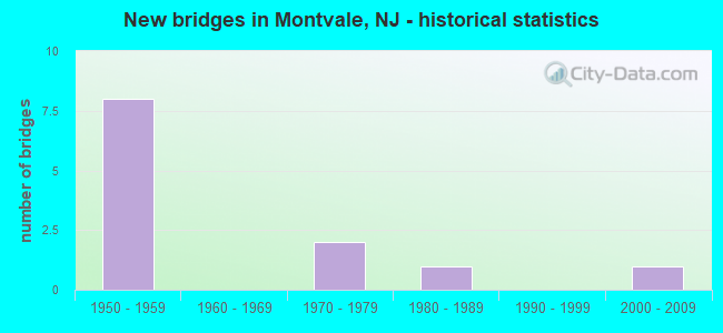
- New bridges - historical statistics
- 81950-1959
- 21970-1979
- 11980-1989
- 12000-2009
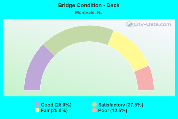
- Bridge Condition - Deck
- 25.0%Good
- 37.5%Satisfactory
- 25.0%Fair
- 12.5%Poor
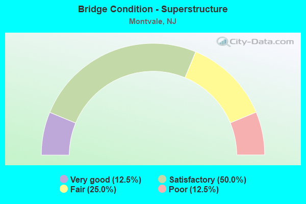
- Bridge Condition - Superstructure
- 12.5%Very good
- 50.0%Satisfactory
- 25.0%Fair
- 12.5%Poor
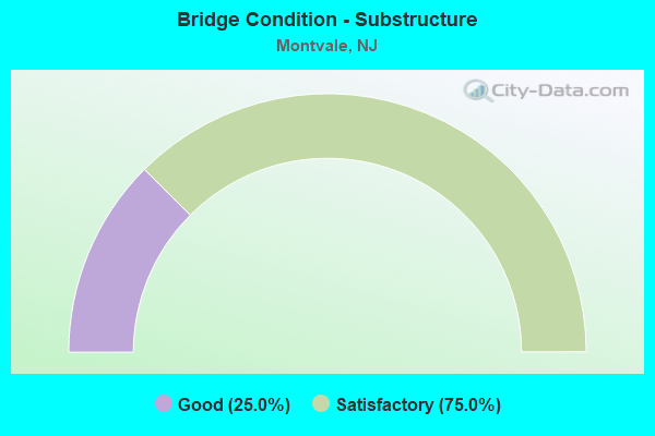
- Bridge Condition - Substructure
- 25.0%Good
- 75.0%Satisfactory
Find on map >> Show street view
Structure Number: 20036A, Location: 0.174 mi W of CR 503 SB (Lat: 41.040069, Lng: -74.032569), Route carried "on" structure: County highway 94, Year Built: 1981, Status: Open, Structure Length: 1.34m (4.40ft), Average Daily Traffic: 3,840 (year 2020), Truck Traffic: 4%, Average Future Daily Traffic: 4,610 (year 2040), Features Intersected: PASCACK BROOK
Minimum Vertical Clearance: 30+ m (98+ ft), Kilometerpoint: 3.566, Lanes on structure: 2, Base Highway Network: Yes, Owner: County Highway Agency, Approaching Roadway Width: 9.1m (29.9ft), Skew: 1 degrees, Material/Design: Prestressed concrete, Design/Construction: Slab, Number Of Spans In Main Unit: 1, Length of Maximum Span: 13.1m (43.0ft), Curb or Sidewalk Widths: Left: 2.1m (6.9ft), Right: 1.2m (3.9ft), Curb-To-Curb Width: 14.0m (45.9ft), Out-to-Out Width: 18.0m (59.1ft)
Condition: Deck: Fair, Superstructure: Fair, Substructure: Good, Channel: Satisfactory, Operating Rating: 54.4 metric tons, Method Used To Determine Operating Rating: Field evaluation and documented engineering judgment, Inventory Rating: 32.7 metric tons, Method Used To Determine Inventory Rating: Field evaluation and documented engineering judgment, Structural Evaluation: Somewhat better than minimum adequacy, Deck Geometry: Superior to present desirable criteria, Waterway Adequacy: Equal to present minimum criteria, Approach Roadway Alignment: Better than present minimum criteria, Length Of Structure Improvement: 1.34m (4.40ft), Designated Inspection Frequency: Every 24 months, Inspection Date: March 2020, Bridge Improvement Cost: $204,000, Total Project Cost: $350,000 ( Estimate for 2020), Deck Structure Type: Concrete Precast Panels, Wearing Surface/Protective System: Wearing Surface: Bituminous, Membrane: Epoxy
Find on map >> Show street view
Structure Number: 20036B, Location: 0.554 mi West of CR 503 (Lat: 41.052881, Lng: -74.034981), Route carried "on" structure: City street , Year Built: 1976, Status: Open, Structure Length: 1.37m (4.49ft), Average Daily Traffic: 2,090 (year 2020), Truck Traffic: 3%, Average Future Daily Traffic: 2,510 (year 2040), Design Load: H 20, Features Intersected: PASCACK BROOK, Facility Carried by Structure: MAGNOLIA AVE
Minimum Vertical Clearance: 30+ m (98+ ft), Kilometerpoint: 0.106, Lanes on structure: 2, Owner: County Highway Agency, Approaching Roadway Width: 6.7m (22.0ft), Skew: 1 degrees, Material/Design: Prestressed concrete, Design/Construction: Slab, Number Of Spans In Main Unit: 1, Length of Maximum Span: 12.8m (42.0ft), Curb or Sidewalk Widths: Left: 1.1m (3.6ft), Right: 1.1m (3.6ft), Curb-To-Curb Width: 6.7m (22.0ft), Out-to-Out Width: 9.4m (30.8ft)
Condition: Deck: Poor, Superstructure: Poor, Substructure: Good, Channel: Satisfactory, Operating Rating: 27.2 metric tons, Method Used To Determine Operating Rating: Load Factor (LF), Inventory Rating: 16.3 metric tons, Method Used To Determine Inventory Rating: Load Factor (LF), Structural Evaluation: Meets minimum limits, Deck Geometry: High priority of replacement, Waterway Adequacy: Equal to present desirable criteria, Approach Roadway Alignment: Meets minimum limits, Length Of Structure Improvement: 1.37m (4.49ft), Designated Inspection Frequency: Every 24 months, Inspection Date: March 2020, Bridge Improvement Cost: $801,000, Roadway Improvement Cost: $100,000, Total Project Cost: $1,815,000 ( Estimate for 2020), Deck Structure Type: Concrete Precast Panels, Wearing Surface/Protective System: Wearing Surface: Bituminous, Membrane: Epoxy
Find on map >> Show street view
Structure Number: 20036C, Location: 0.11 mi N of Grand Av (Lat: 41.043569, Lng: -74.014231), Route carried "on" structure: County highway 53, Year Built: 2004, Status: Open, Structure Length: 0.82m (2.69ft), Average Daily Traffic: 7,190 (year 2020), Truck Traffic: 4%, Average Future Daily Traffic: 8,630 (year 2040), Design Load: HS 25 or greater, Features Intersected: CHERRY BROOK
Minimum Vertical Clearance: 30+ m (98+ ft), Kilometerpoint: 9.045, Lanes on structure: 2, Owner: County Highway Agency, Approaching Roadway Width: 12.2m (40.0ft), Material/Design: Prestressed concrete, Design/Construction: Slab, Number Of Spans In Main Unit: 1, Length of Maximum Span: 6.7m (22.0ft), Curb or Sidewalk Widths: Left: 2.4m (7.9ft), Right: 2.9m (9.5ft), Curb-To-Curb Width: 12.2m (40.0ft), Out-to-Out Width: 19.5m (64.0ft)
Condition: Deck: Good, Superstructure: Very good, Substructure: Satisfactory, Channel: Satisfactory, Structural Evaluation: Equal to present minimum criteria, Deck Geometry: Somewhat better than minimum adequacy, Waterway Adequacy: Superior to present desirable criteria, Approach Roadway Alignment: Equal to present minimum criteria, Designated Inspection Frequency: Every 24 months, Inspection Date: March 2020, Deck Structure Type: Concrete Cast-file-Place, Wearing Surface/Protective System: Wearing Surface: Monolithic Concrete, Deck Protection: Epoxy Coated Reinforcing
Find on map >> Show street view
Structure Number: 20036D, Location: 0.016 mi East CR 53 (Lat: 41.041511, Lng: -74.012669), Route carried "on" structure: County highway 94, Year Built: 1973, Status: Open, Structure Length: 1.13m (3.71ft), Average Daily Traffic: 3,840 (year 2020), Truck Traffic: 3%, Average Future Daily Traffic: 4,610 (year 2040), Design Load: H 20, Features Intersected: CHERRY BROOK
Minimum Vertical Clearance: 30+ m (98+ ft), Kilometerpoint: 5.288, Lanes on structure: 2, Owner: County Highway Agency, Approaching Roadway Width: 12.2m (40.0ft), Skew: 3 degrees, Material/Design: Prestressed concrete, Design/Construction: Slab, Number Of Spans In Main Unit: 1, Length of Maximum Span: 10.1m (33.1ft), Curb or Sidewalk Widths: Left: 1.2m (3.9ft), Right: 1.2m (3.9ft), Curb-To-Curb Width: 12.2m (40.0ft), Out-to-Out Width: 15.2m (49.9ft)
Condition: Deck: Fair, Superstructure: Fair, Substructure: Satisfactory, Channel: Satisfactory, Operating Rating: 33.6 metric tons, Method Used To Determine Operating Rating: Load Factor (LF), Inventory Rating: 20.0 metric tons, Method Used To Determine Inventory Rating: Load Factor (LF), Structural Evaluation: Somewhat better than minimum adequacy, Deck Geometry: Equal to present minimum criteria, Waterway Adequacy: Superior to present desirable criteria, Approach Roadway Alignment: Somewhat better than minimum adequacy, Designated Inspection Frequency: Every 24 months, Inspection Date: March 2020, Deck Structure Type: Concrete Precast Panels, Wearing Surface/Protective System: Wearing Surface: Bituminous, Membrane: Epoxy
Find on map >> Show street view
Structure Number: 361714S, Location: 8 MI N OF GSP & RT 17 JCT (Lat: 41.055450, Lng: -74.066172), Route carried "on" structure: Other road GSP, Year Built: 1956, Status: Open, Structure Length: 1.95m (6.40ft), Average Daily Traffic: 41,100 (year 2020), Truck Traffic: 1%, Average Future Daily Traffic: 50,149 (year 2040), Design Load: H 20, Features Intersected: GRAND AVENUE (CR 94), Facility Carried by Structure: GARDEN ST PKWY SB
Minimum Vertical Clearance: 30+ m (98+ ft), Kilometerpoint: 276.035, Lanes on structure: 3, Lanes under structure: 4, Base Highway Network: Yes, Toll: On toll road, Owner: State Toll Authority, Approaching Roadway Width: 13.1m (43.0ft), Skew: 1 degrees, Material/Design: Prestressed concrete, Design/Construction: Stringer/Multi-beam, Number Of Spans In Main Unit: 1, Length of Maximum Span: 17.7m (58.1ft), Curb-To-Curb Width: 13.3m (43.6ft), Out-to-Out Width: 14.2m (46.6ft)
Condition: Deck: Satisfactory, Superstructure: Satisfactory, Substructure: Satisfactory, Operating Rating: 51.2 metric tons, Method Used To Determine Operating Rating: Load and Resistance Factor Rating (LRFR) rating reported by rating factor(RF) method using HL-93 loadings, Inventory Rating: 29.5 metric tons, Method Used To Determine Inventory Rating: Load and Resistance Factor Rating (LRFR) rating reported by rating factor(RF) method using HL-93 loadings, Structural Evaluation: Equal to present minimum criteria, Deck Geometry: High priority of replacement, Underclear: High priority of corrective action, Approach Roadway Alignment: Equal to present desirable criteria, Designated Inspection Frequency: Every 24 months, Inspection Date: May 2020, Deck Structure Type: Concrete Cast-file-Place, Wearing Surface/Protective System: Wearing Surface: Bituminous, Membrane: Preformed Fabric
Find on map >> Show street view
Structure Number: 361715N, Location: 8 MI N OF GSP & RT 17 JCT (Lat: 41.055178, Lng: -74.065372), Route carried "on" structure: Other road GSP, Year Built: 1956, Status: Open, Structure Length: 2.16m (7.09ft), Average Daily Traffic: 35,898 (year 2020), Truck Traffic: 1%, Average Future Daily Traffic: 43,803 (year 2040), Design Load: H 20, Features Intersected: GRAND AVENUE (CR 94), Facility Carried by Structure: GARDEN ST PKWY NB
Minimum Vertical Clearance: 30+ m (98+ ft), Kilometerpoint: 276.035, Lanes on structure: 2, Lanes under structure: 4, Base Highway Network: Yes, Toll: On toll road, Owner: State Toll Authority, Approaching Roadway Width: 12.8m (42.0ft), Skew: 3 degrees, Material/Design: Prestressed concrete, Design/Construction: Stringer/Multi-beam, Number Of Spans In Main Unit: 1, Length of Maximum Span: 19.5m (64.0ft), Curb-To-Curb Width: 13.0m (42.7ft), Out-to-Out Width: 13.9m (45.6ft)
Condition: Deck: Satisfactory, Superstructure: Satisfactory, Substructure: Satisfactory, Operating Rating: 57.7 metric tons, Method Used To Determine Operating Rating: Load and Resistance Factor Rating (LRFR) rating reported by rating factor(RF) method using HL-93 loadings, Inventory Rating: 28.8 metric tons, Method Used To Determine Inventory Rating: Load and Resistance Factor Rating (LRFR) rating reported by rating factor(RF) method using HL-93 loadings, Structural Evaluation: Equal to present minimum criteria, Deck Geometry: Superior to present desirable criteria, Underclear: High priority of corrective action, Approach Roadway Alignment: Equal to present desirable criteria, Designated Inspection Frequency: Every 24 months, Inspection Date: May 2020, Deck Structure Type: Concrete Cast-file-Place, Wearing Surface/Protective System: Wearing Surface: Bituminous, Membrane: Preformed Fabric
Find on map >> Show street view
Structure Number: 361716S, Location: 8.3 MI N OF GSP&RT 17 JCT (Lat: 41.058256, Lng: -74.065831), Route carried "on" structure: Other road GSP, Year Built: 1956, Status: Open, Structure Length: 1.98m (6.50ft), Average Daily Traffic: 43,028 (year 2020), Truck Traffic: 1%, Average Future Daily Traffic: 52,503 (year 2040), Design Load: H 20, Features Intersected: SUMMIT AVENUE (CR 96), Facility Carried by Structure: GARDEN ST PRKWY SB
Minimum Vertical Clearance: 30+ m (98+ ft), Kilometerpoint: 276.389, Lanes on structure: 2, Lanes under structure: 2, Base Highway Network: Yes, Toll: On toll road, Owner: State Toll Authority, Approaching Roadway Width: 12.8m (42.0ft), Skew: 2 degrees, Material/Design: Prestressed concrete, Design/Construction: Stringer/Multi-beam, Number Of Spans In Main Unit: 1, Length of Maximum Span: 18.0m (59.1ft), Curb-To-Curb Width: 12.9m (42.3ft), Out-to-Out Width: 13.8m (45.3ft)
Condition: Deck: Good, Superstructure: Satisfactory, Substructure: Satisfactory, Operating Rating: 64.5 metric tons, Method Used To Determine Operating Rating: Load and Resistance Factor Rating (LRFR) rating reported by rating factor(RF) method using HL-93 loadings, Inventory Rating: 33.4 metric tons, Method Used To Determine Inventory Rating: Load and Resistance Factor Rating (LRFR) rating reported by rating factor(RF) method using HL-93 loadings, Structural Evaluation: Equal to present minimum criteria, Deck Geometry: Superior to present desirable criteria, Underclear: Meets minimum limits, Approach Roadway Alignment: Equal to present desirable criteria, Designated Inspection Frequency: Every 24 months, Inspection Date: May 2020, Deck Structure Type: Concrete Cast-file-Place, Wearing Surface/Protective System: Wearing Surface: Bituminous, Membrane: Preformed Fabric
Find on map >> Show street view
Structure Number: 361717N, Location: 8.3 MI W OF GSP&RT 17 JCT (Lat: 41.058331, Lng: -74.065108), Route carried "on" structure: Other road GSP, Year Built: 1956, Status: Open, Structure Length: 2.01m (6.59ft), Average Daily Traffic: 29,239 (year 2020), Truck Traffic: 1%, Average Future Daily Traffic: 35,678 (year 2040), Design Load: H 20, Features Intersected: SUMMIT AVENUE (CR 96), Facility Carried by Structure: GARDEN ST PRKWY NB
Minimum Vertical Clearance: 30+ m (98+ ft), Kilometerpoint: 276.389, Lanes on structure: 2, Lanes under structure: 2, Base Highway Network: Yes, Toll: On toll road, Owner: State Toll Authority, Approaching Roadway Width: 12.8m (42.0ft), Skew: 2 degrees, Material/Design: Prestressed concrete, Design/Construction: Stringer/Multi-beam, Number Of Spans In Main Unit: 1, Length of Maximum Span: 18.3m (60.0ft), Curb-To-Curb Width: 12.7m (41.7ft), Out-to-Out Width: 13.8m (45.3ft)
Condition: Deck: Satisfactory, Superstructure: Satisfactory, Substructure: Satisfactory, Operating Rating: 62.9 metric tons, Method Used To Determine Operating Rating: Load and Resistance Factor Rating (LRFR) rating reported by rating factor(RF) method using HL-93 loadings, Inventory Rating: 31.4 metric tons, Method Used To Determine Inventory Rating: Load and Resistance Factor Rating (LRFR) rating reported by rating factor(RF) method using HL-93 loadings, Structural Evaluation: Equal to present minimum criteria, Deck Geometry: Better than present minimum criteria, Underclear: Meets minimum limits, Approach Roadway Alignment: Better than present minimum criteria, Designated Inspection Frequency: Every 24 months, Inspection Date: May 2020, Deck Structure Type: Concrete Cast-file-Place, Wearing Surface/Protective System: Wearing Surface: Bituminous, Membrane: Preformed Fabric
Find on map >> Show street view
Structure Number: 361714S, Location: 8 MI N OF GSP & RT 17 JCT (Lat: 41.055450, Lng: -74.066172), Route carried "under" structure: County highway 94, Year Built: 1956, Structure Length: 0. m, Average Daily Traffic: 10,559 (year 2020), Truck Traffic: 4%, Features Intersected: GRAND AVENUE (CR 94), Facility Carried by Structure: GARDEN ST PKWY SB
Minimum Vertical Clearance: 4.60m (15.09ft), Kilometerpoint: 0.161, Lanes on structure: 3, Lanes under structure: 4, Material/Design: Prestressed concrete, Design/Construction: Stringer/Multi-beam, Length of Maximum Span: 17.7m (58.1ft)
Find on map >> Show street view
Structure Number: 361715N, Location: 8 MI N OF GSP & RT 17 JCT (Lat: 41.055178, Lng: -74.065372), Route carried "under" structure: County highway 94, Year Built: 1956, Structure Length: 0. m, Average Daily Traffic: 10,559 (year 2020), Truck Traffic: 4%, Features Intersected: GRAND AVENUE (CR 94), Facility Carried by Structure: GARDEN ST PKWY NB
Minimum Vertical Clearance: 4.62m (15.16ft), Kilometerpoint: 0.241, Lanes on structure: 2, Lanes under structure: 4, Material/Design: Prestressed concrete, Design/Construction: Stringer/Multi-beam, Length of Maximum Span: 19.5m (64.0ft)
Find on map >> Show street view
Structure Number: 361716S, Location: 8.3 MI N OF GSP&RT 17 JCT (Lat: 41.058256, Lng: -74.065831), Route carried "under" structure: County highway 96, Year Built: 1956, Structure Length: 0. m, Average Daily Traffic: 11,364 (year 2020), Truck Traffic: 4%, Features Intersected: SUMMIT AVENUE (CR 96), Facility Carried by Structure: GARDEN ST PRKWY SB
Minimum Vertical Clearance: 4.40m (14.44ft), Kilometerpoint: 5.423, Lanes on structure: 2, Lanes under structure: 2, Material/Design: Prestressed concrete, Design/Construction: Stringer/Multi-beam, Length of Maximum Span: 18.0m (59.1ft)
Find on map >> Show street view
Structure Number: 361717N, Location: 8.3 MI W OF GSP&RT 17 JCT (Lat: 41.058331, Lng: -74.065108), Route carried "under" structure: County highway 96, Year Built: 1956, Structure Length: 0. m, Average Daily Traffic: 11,368 (year 2020), Truck Traffic: 4%, Features Intersected: SUMMIT AVENUE (CR 96), Facility Carried by Structure: GARDEN ST PRKWY NB
Minimum Vertical Clearance: 4.44m (14.57ft), Kilometerpoint: 5.488, Lanes on structure: 2, Lanes under structure: 2, Material/Design: Prestressed concrete, Design/Construction: Stringer/Multi-beam, Length of Maximum Span: 18.3m (60.0ft)