Bridge Statistics for Monument, Colorado (CO)
Condition, Traffic, Stress, Structural Evaluation, Project Costs
- National Bridge Inventory (NBI) Statistics
- 13Number of bridges
- 148ft / 44.8mTotal length
- $2,847,000Total costs
- 381,466Total average daily traffic
- 30,518Total average daily truck traffic
- National Bridge Inventory (NBI) Registered Bridges for Monument
- No street view available for this location
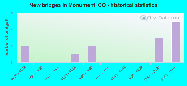
- New bridges - historical statistics
- 21920-1929
- 11950-1959
- 21960-1969
- 32000-2009
- 52010-2019
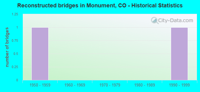
- Reconstructed bridges - Historical Statistics
- 11950-1959
- 01960-1969
- 01970-1979
- 01980-1989
- 11990-1999
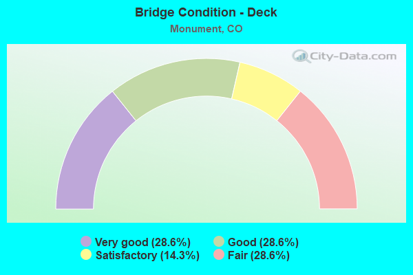
- Bridge Condition - Deck
- 28.6%Very good
- 28.6%Good
- 14.3%Satisfactory
- 28.6%Fair
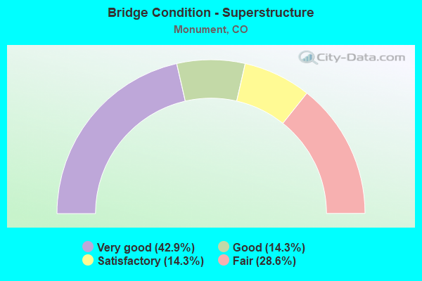
- Bridge Condition - Superstructure
- 42.9%Very good
- 14.3%Good
- 14.3%Satisfactory
- 28.6%Fair
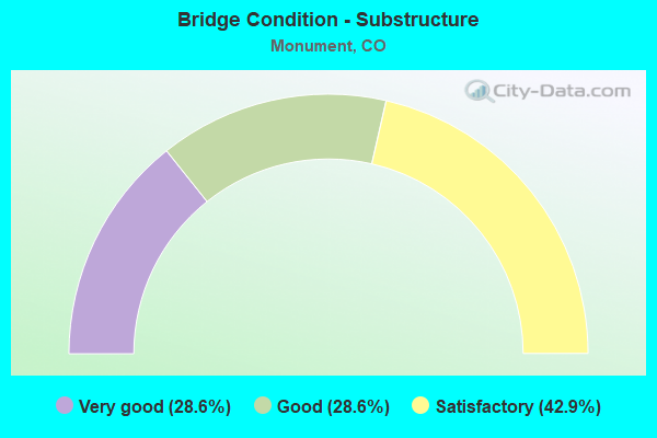
- Bridge Condition - Substructure
- 28.6%Very good
- 28.6%Good
- 42.9%Satisfactory
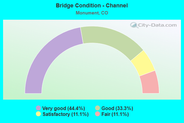
- Bridge Condition - Channel
- 44.4%Very good
- 33.3%Good
- 11.1%Satisfactory
- 11.1%Fair
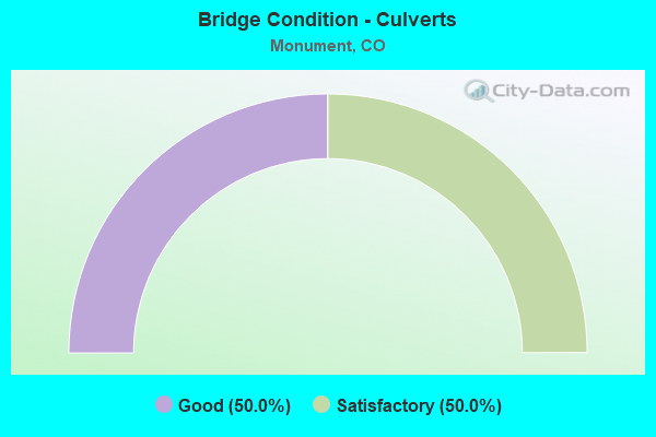
- Bridge Condition - Culverts
- 50.0%Good
- 50.0%Satisfactory
Find on map >> Show street view
Structure Number: EPC0032-02.30AA, Location: 0.5 MI W OF I-25 (Lat: 39.056722, Lng: -104.862306), Route carried "on" structure: County highway , Year Built: 2015, Status: Open, Structure Length: 13.36m (43.83ft), Average Daily Traffic: 4,184 (year 2021), Truck Traffic: 4%, Average Future Daily Traffic: 5,481 (year 2041), Design Load: HS 20, Features Intersected: MONUMENT CREEK, Facility Carried by Structure: BAPTIST ROAD
Minimum Vertical Clearance: 30+ m (98+ ft), Kilometerpoint: 0.151, Lanes on structure: 2, Owner: County Highway Agency, Approaching Roadway Width: 15.5m (50.9ft), Material/Design: Prestressed concrete continuous, Design/Construction: Stringer/Multi-beam, Number Of Spans In Main Unit: 3, Length of Maximum Span: 43.3m (142.1ft), Curb or Sidewalk Widths: Left: 3.2m (10.5ft), Right: 0.0m, Curb-To-Curb Width: 12.2m (40.0ft), Out-to-Out Width: 17.6m (57.7ft)
Condition: Deck: Very good, Superstructure: Very good, Substructure: Very good, Channel: Very good, Operating Rating: 36.3 metric tons, Method Used To Determine Operating Rating: Field evaluation and documented engineering judgment, Inventory Rating: 32.7 metric tons, Method Used To Determine Inventory Rating: Field evaluation and documented engineering judgment, Structural Evaluation: Equal to present desirable criteria, Deck Geometry: Equal to present minimum criteria, Waterway Adequacy: Equal to present desirable criteria, Approach Roadway Alignment: Better than present minimum criteria, Designated Inspection Frequency: Every 24 months, Inspection Date: January 2022, Deck Structure Type: Concrete Cast-file-Place, Wearing Surface/Protective System: Wearing Surface: Bituminous, Membrane: Preformed Fabric, Deck Protection: Epoxy Coated Reinforcing
Find on map >> Show street view
Structure Number: EPC0032-03.18, Location: 0.2 MI E OF I-25 (Lat: 39.056400, Lng: -104.846503), Route carried "on" structure: County highway , Year Built: 2012, Status: Open, Structure Length: 0.98m (3.22ft), Average Daily Traffic: 17,866 (year 2021), Truck Traffic: 4%, Average Future Daily Traffic: 23,404 (year 2041), Design Load: HS 20, Features Intersected: JACKSON CREEK, Facility Carried by Structure: BAPTIST ROAD
Minimum Vertical Clearance: 30.17m (98.98ft), Kilometerpoint: 1.746, Lanes on structure: 8, Owner: County Highway Agency, Approaching Roadway Width: 32.3m (106.0ft), Skew: 33 degrees, Material/Design: Concrete, Design/Construction: Culvert, Number Of Spans In Main Unit: 3, Length of Maximum Span: 3.3m (10.8ft), Curb or Sidewalk Widths: Left: 3.4m (11.2ft), Right: 0.0m, Curb-To-Curb Width: 11.8m (38.7ft), Out-to-Out Width: 50.3m (165.0ft)
Condition: Channel: Fair, Culverts: Satisfactory, Structural Evaluation: Equal to present minimum criteria, Deck Geometry: High priority of replacement, Waterway Adequacy: Equal to present desirable criteria, Approach Roadway Alignment: Equal to present desirable criteria, Designated Inspection Frequency: Every 24 months, Inspection Date: January 2022
Find on map >> Show street view
Structure Number: EPC0840-00.5, Location: .1 MI W OF MITCHELL AVE (Lat: 39.073492, Lng: -104.875000), Route carried "on" structure: County highway , Year Built: 1965, Status: Posted for load, Structure Length: 1.81m (5.94ft), Average Daily Traffic: 742 (year 2021), Truck Traffic: 4%, Average Future Daily Traffic: 972 (year 2041), Features Intersected: MONUMENT CREEK, Facility Carried by Structure: ARNOLD AVE
Minimum Vertical Clearance: 30+ m (98+ ft), Kilometerpoint: 0.798, Lanes on structure: 2, Owner: County Highway Agency, Approaching Roadway Width: 7.6m (24.9ft), Material/Design: Prestressed concrete, Design/Construction: Tee Beam, Number Of Spans In Main Unit: 2, Length of Maximum Span: 8.7m (28.5ft), Curb-To-Curb Width: 9.0m (29.5ft), Out-to-Out Width: 9.1m (29.9ft)
Condition: Deck: Fair, Superstructure: Fair, Substructure: Satisfactory, Channel: Satisfactory, Operating Rating: 17.1 metric tons, Method Used To Determine Operating Rating: Load Factor (LF), Inventory Rating: 14.6 metric tons, Method Used To Determine Inventory Rating: Load Factor (LF), Structural Evaluation: Meets minimum limits, Deck Geometry: Somewhat better than minimum adequacy, Waterway Adequacy: Equal to present desirable criteria, Approach Roadway Alignment: Equal to present desirable criteria, Bridge Posting: Required (Relationship of Operating Rating to Maximum Legal Load: > 39.9% below), Designated Inspection Frequency: Every 24 months, Inspection Date: January 2022, Deck Structure Type: Other, Wearing Surface/Protective System: Wearing Surface: Bituminous
Find on map >> Show street view
Structure Number: H-17-BB, Location: JUST SOUTH OF SH 105 (Lat: 39.089592, Lng: -104.864297), Route carried "on" structure: Ramp Interstate 25A, Year Built: 2004, Status: Open, Structure Length: 9.88m (32.41ft), Average Daily Traffic: 84,000 (year 2020), Truck Traffic: 9%, Average Future Daily Traffic: 121,800 (year 2040), Design Load: HS 25 or greater, Features Intersected: DIRTY WOMAN CREEK R, Facility Carried by Structure: I25 ML
Minimum Vertical Clearance: 30+ m (98+ ft), Kilometerpoint: 0.557, Lanes on structure: 4, Owner: State Highway Agency, Approaching Roadway Width: 21.9m (71.9ft), Skew: 32 degrees, Material/Design: Steel continuous, Design/Construction: Stringer/Multi-beam, Number Of Spans In Main Unit: 3, Length of Maximum Span: 40.0m (131.2ft), Curb-To-Curb Width: 21.6m (70.9ft), Out-to-Out Width: 23.1m (75.8ft)
Condition: Deck: Good, Superstructure: Good, Substructure: Good, Channel: Very good, Operating Rating: 66.6 metric tons, Method Used To Determine Operating Rating: Load Factor (LF), Inventory Rating: 39.8 metric tons, Method Used To Determine Inventory Rating: Load Factor (LF), Structural Evaluation: Better than present minimum criteria, Deck Geometry: Superior to present desirable criteria, Waterway Adequacy: Equal to present desirable criteria, Approach Roadway Alignment: Equal to present desirable criteria, Designated Inspection Frequency: Every 24 months, Inspection Date: Febuary 2021, Deck Structure Type: Concrete Precast Panels, Wearing Surface/Protective System: Wearing Surface: Other, Membrane: Other, Deck Protection: Epoxy Coated Reinforcing
Find on map >> Show street view
Structure Number: H-17-BK, Location: 9.0 MI N OF JCT SH 83 ML (Lat: 39.072011, Lng: -104.857642), Route carried "on" structure: Interstate 25A, Year Built: 1926, Year Reconstructed: 1963, Status: Open, Structure Length: 0.64m (2.10ft), Average Daily Traffic: 84,000 (year 2020), Truck Traffic: 9%, Average Future Daily Traffic: 121,800 (year 2040), Features Intersected: TEACHOUT CREEK, Facility Carried by Structure: I 25 ML
Minimum Vertical Clearance: 30+ m (98+ ft), Kilometerpoint: 256.232, Lanes on structure: 6, Base Highway Network: Yes, Owner: State Highway Agency, Approaching Roadway Width: 34.1m (111.9ft), Skew: 20 degrees, Material/Design: Concrete, Design/Construction: Culvert, Number Of Spans In Main Unit: 2, Length of Maximum Span: 3.0m (9.8ft), Out-to-Out Width: 52.0m (170.6ft)
Condition: Channel: Very good, Culverts: Good, Operating Rating: 42.0 metric tons, Method Used To Determine Operating Rating: Load Factor (LF), Inventory Rating: 30.2 metric tons, Method Used To Determine Inventory Rating: Load Factor (LF), Structural Evaluation: Better than present minimum criteria, Waterway Adequacy: Equal to present desirable criteria, Approach Roadway Alignment: Equal to present desirable criteria, Designated Inspection Frequency: Every 24 months, Inspection Date: Febuary 2021
Find on map >> Show street view
Structure Number: H-17-CA, Location: JUST SOUTH OF SH 105 (Lat: 39.089622, Lng: -104.861808), Route carried "on" structure: Interstate 25A, Year Built: 1958, Year Reconstructed: 2003, Status: Open, Structure Length: 0.62m (2.03ft), Average Daily Traffic: 67,000 (year 2020), Truck Traffic: 6%, Average Future Daily Traffic: 98,490 (year 2040), Design Load: HL 93, Features Intersected: UNNAMED DRAINAGE, Facility Carried by Structure: I-25 ML
Minimum Vertical Clearance: 30+ m (98+ ft), Kilometerpoint: 258.221, Lanes on structure: 8, Base Highway Network: Yes, Owner: State Highway Agency, Approaching Roadway Width: 45.7m (149.9ft), Skew: 31 degrees, Material/Design: Concrete, Design/Construction: Culvert, Number Of Spans In Main Unit: 2, Length of Maximum Span: 3.2m (10.5ft), Out-to-Out Width: 102.2m (335.3ft)
Condition: Channel: Good, Culverts: Satisfactory, Operating Rating: 89.8 metric tons, Method Used To Determine Operating Rating: Field evaluation and documented engineering judgment, Inventory Rating: 89.8 metric tons, Method Used To Determine Inventory Rating: Field evaluation and documented engineering judgment, Structural Evaluation: Equal to present minimum criteria, Waterway Adequacy: Equal to present desirable criteria, Approach Roadway Alignment: Equal to present desirable criteria, Designated Inspection Frequency: Every 24 months, Inspection Date: Febuary 2021
Find on map >> Show street view
Structure Number: H-17-CZ, Location: MONUMENT INTERCHANGE (Lat: 39.092517, Lng: -104.862364), Route carried "on" structure: State highway 105A, Year Built: 2004, Status: Open, Structure Length: 5.75m (18.86ft), Average Daily Traffic: 19,000 (year 2020), Truck Traffic: 3%, Average Future Daily Traffic: 26,410 (year 2040), Design Load: HS 25 or greater, Features Intersected: I 25 ML, Facility Carried by Structure: SH 105 ML
Minimum Vertical Clearance: 30+ m (98+ ft), Kilometerpoint: 0.645, Lanes on structure: 6, Lanes under structure: 7, Owner: State Highway Agency, Approaching Roadway Width: 25.3m (83.0ft), Material/Design: Prestressed concrete, Design/Construction: Stringer/Multi-beam, Number Of Spans In Main Unit: 2, Length of Maximum Span: 28.0m (91.9ft), Curb or Sidewalk Widths: Left: 0.0m, Right: 3.0m (9.8ft), Curb-To-Curb Width: 25.3m (83.0ft), Out-to-Out Width: 29.1m (95.5ft)
Condition: Deck: Good, Superstructure: Very good, Substructure: Good, Operating Rating: 56.9 metric tons, Method Used To Determine Operating Rating: Load Factor (LF), Inventory Rating: 47.1 metric tons, Method Used To Determine Inventory Rating: Load Factor (LF), Structural Evaluation: Better than present minimum criteria, Deck Geometry: Somewhat better than minimum adequacy, Underclear: Equal to present minimum criteria, Approach Roadway Alignment: Equal to present desirable criteria, Length Of Structure Improvement: 6.65m (21.82ft), Designated Inspection Frequency: Every 24 months, Inspection Date: January 2022, Bridge Improvement Cost: $1,856,000, Roadway Improvement Cost: $185,000, Total Project Cost: $2,784,000, Deck Structure Type: Concrete Precast Panels, Wearing Surface/Protective System: Wearing Surface: Monolithic Concrete, Deck Protection: Epoxy Coated Reinforcing
Find on map >> Show street view
Structure Number: H-17-DC, Location: 7.9 MI N OF JCT SH 83 ML (Lat: 39.056528, Lng: -104.851792), Route carried "on" structure: County highway , Year Built: 2010, Status: Open, Structure Length: 7.78m (25.52ft), Average Daily Traffic: 17,699 (year 2021), Truck Traffic: 12%, Average Future Daily Traffic: 23,186 (year 2041), Design Load: HL 93, Features Intersected: I 25 ML, Facility Carried by Structure: BAPTIST RD-CR32
Minimum Vertical Clearance: 30+ m (98+ ft), Kilometerpoint: 1.095, Lanes on structure: 8, Lanes under structure: 6, Owner: State Highway Agency, Approaching Roadway Width: 32.3m (106.0ft), Skew: 22 degrees, Material/Design: Prestressed concrete continuous, Design/Construction: Box Beam or Girders - Single/Spread, Number Of Spans In Main Unit: 2, Length of Maximum Span: 38.7m (127.0ft), Curb or Sidewalk Widths: Left: 3.2m (10.5ft), Right: 0.0m, Curb-To-Curb Width: 37.3m (122.4ft), Out-to-Out Width: 38.6m (126.6ft)
Condition: Deck: Very good, Superstructure: Very good, Substructure: Very good, Operating Rating: 55.1 metric tons, Method Used To Determine Operating Rating: Load and Resistance Factor Rating (LRFR) rating reported by rating factor(RF) method using HL-93 loadings, Inventory Rating: 42.1 metric tons, Method Used To Determine Inventory Rating: Load and Resistance Factor Rating (LRFR) rating reported by rating factor(RF) method using HL-93 loadings, Structural Evaluation: Equal to present desirable criteria, Deck Geometry: Superior to present desirable criteria, Underclear: Superior to present desirable criteria, Approach Roadway Alignment: Equal to present desirable criteria, Designated Inspection Frequency: Every 24 months, Inspection Date: Febuary 2021, Deck Structure Type: Concrete Cast-file-Place, Wearing Surface/Protective System: Wearing Surface: Other, Membrane: Other, Deck Protection: Epoxy Coated Reinforcing
Find on map >> Show street view
Structure Number: H-17-U, Location: .7 W OFI25/MONUMENT INTER (Lat: 39.097819, Lng: -104.871372), Route carried "on" structure: State highway 105A, Year Built: 1927, Status: Open, Structure Length: 1.10m (3.61ft), Average Daily Traffic: 8,500 (year 2020), Truck Traffic: 2%, Average Future Daily Traffic: 10,455 (year 2040), Design Load: H 15, Features Intersected: CRYSTAL CREEK, Facility Carried by Structure: SH 105 ML
Minimum Vertical Clearance: 30+ m (98+ ft), Kilometerpoint: 1.841, Lanes on structure: 2, Owner: State Highway Agency, Approaching Roadway Width: 7.9m (25.9ft), Material/Design: Concrete, Design/Construction: Stringer/Multi-beam, Number Of Spans In Main Unit: 1, Length of Maximum Span: 10.0m (32.8ft), Curb-To-Curb Width: 9.1m (29.9ft), Out-to-Out Width: 9.9m (32.5ft)
Condition: Deck: Satisfactory, Superstructure: Satisfactory, Substructure: Satisfactory, Channel: Good, Operating Rating: 69.0 metric tons, Method Used To Determine Operating Rating: Load Factor (LF), Inventory Rating: 40.8 metric tons, Method Used To Determine Inventory Rating: Load Factor (LF), Structural Evaluation: Equal to present minimum criteria, Deck Geometry: High priority of corrective action, Waterway Adequacy: Equal to present desirable criteria, Approach Roadway Alignment: Equal to present desirable criteria, Length Of Structure Improvement: 1.10m (3.61ft), Designated Inspection Frequency: Every 24 months, Inspection Date: Febuary 2020, Bridge Improvement Cost: $42,000, Roadway Improvement Cost: $4,000, Total Project Cost: $63,000, Deck Structure Type: Concrete Cast-file-Place, Wearing Surface/Protective System: Wearing Surface: Bituminous
Find on map >> Show street view
Structure Number: MONUMENT-LTHRCH, Location: .7MI E of JACKSON CR PKWY (Lat: 39.069083, Lng: -104.841389), Route carried "on" structure: Interstate , Year Built: 2019, Status: Open, Structure Length: 1.02m (3.35ft), Average Daily Traffic: 3,367 (year 2021), Average Future Daily Traffic: 4,411 (year 2041), Design Load: HL 93, Features Intersected: LEATHER CHAPS DR, Facility Carried by Structure: JACKSON CREEK
Minimum Vertical Clearance: 30+ m (98+ ft), Kilometerpoint: 1.823, Lanes on structure: 3, Owner: Town or Township Highway Agency, Approaching Roadway Width: 14.6m (47.9ft), Skew: 3 degrees, Material/Design: Concrete, Design/Construction: Culvert, Number Of Spans In Main Unit: 3, Length of Maximum Span: 3.0m (9.8ft), Curb or Sidewalk Widths: Left: 0.0m, Right: 1.5m (4.9ft), Out-to-Out Width: 34.2m (112.2ft)
Condition: Channel: Very good, Culverts: Good, Operating Rating: 62.2 metric tons, Method Used To Determine Operating Rating: Load and Resistance Factor Rating (LRFR) rating reported by rating factor(RF) method using HL-93 loadings, Inventory Rating: 48.0 metric tons, Method Used To Determine Inventory Rating: Load and Resistance Factor Rating (LRFR) rating reported by rating factor(RF) method using HL-93 loadings, Structural Evaluation: Better than present minimum criteria, Waterway Adequacy: Equal to present desirable criteria, Approach Roadway Alignment: Equal to present desirable criteria, Designated Inspection Frequency: Every 24 months, Inspection Date: January 2022
Find on map >> Show street view
Structure Number: MONUMENT-MTHRM, Location: W OF MITCHELL ROAD (Lat: 39.082583, Lng: -104.876444), Route carried "on" structure: City street , Year Built: 1965, Status: Posted for load, Structure Length: 1.84m (6.04ft), Average Daily Traffic: 1,108 (year 2021), Truck Traffic: 5%, Average Future Daily Traffic: 1,451 (year 2041), Features Intersected: MONUMENT CREEK, Facility Carried by Structure: MT HERMAN ROAD
Minimum Vertical Clearance: 30+ m (98+ ft), Kilometerpoint: 0.101, Lanes on structure: 2, Owner: City or Municipal Highway Agency, Approaching Roadway Width: 7.6m (24.9ft), Material/Design: Prestressed concrete, Design/Construction: Tee Beam, Number Of Spans In Main Unit: 2, Length of Maximum Span: 8.7m (28.5ft), Curb-To-Curb Width: 9.0m (29.5ft), Out-to-Out Width: 9.2m (30.2ft)
Condition: Deck: Fair, Superstructure: Fair, Substructure: Satisfactory, Channel: Good, Operating Rating: 17.1 metric tons, Method Used To Determine Operating Rating: Load Factor (LF), Inventory Rating: 14.6 metric tons, Method Used To Determine Inventory Rating: Load Factor (LF), Structural Evaluation: Meets minimum limits, Deck Geometry: Somewhat better than minimum adequacy, Waterway Adequacy: Better than present minimum criteria, Approach Roadway Alignment: Equal to present desirable criteria, Bridge Posting: Required (Relationship of Operating Rating to Maximum Legal Load: > 39.9% below), Designated Inspection Frequency: Every 24 months, Inspection Date: January 2022, Deck Structure Type: Other, Wearing Surface/Protective System: Wearing Surface: Bituminous
Find on map >> Show street view
Structure Number: H-17-CZ, Location: MONUMENT INTERCHANGE (Lat: 39.092517, Lng: -104.862364), Route carried "under" structure: Interstate 25A, Year Built: 2004, Structure Length: 0. m, Average Daily Traffic: 59,000 (year 2011), Truck Traffic: 10%, Features Intersected: I 25 ML, Facility Carried by Structure: SH 105 ML
Minimum Vertical Clearance: 5.84m (19.16ft), Kilometerpoint: 258.723, Lanes on structure: 6, Lanes under structure: 7, Material/Design: Prestressed concrete, Design/Construction: Stringer/Multi-beam, Length of Maximum Span: 28.0m (91.9ft)
Find on map >> Show street view
Structure Number: H-17-DC, Location: 7.9 MI N OF JCT SH 83 ML (Lat: 39.056528, Lng: -104.851792), Route carried "under" structure: Interstate 25A, Year Built: 2010, Structure Length: 0. m, Average Daily Traffic: 15,000 (year 2014), Truck Traffic: 11%, Features Intersected: I 25 ML, Facility Carried by Structure: BAPTIST RD-CR32
Minimum Vertical Clearance: 5.21m (17.09ft), Kilometerpoint: 1.096, Lanes on structure: 8, Lanes under structure: 6, Material/Design: Prestressed concrete continuous, Design/Construction: Box Beam or Girders - Single/Spread, Length of Maximum Span: 38.7m (127.0ft)