Bridge Statistics for Mooers, New York (NY)
Condition, Traffic, Stress, Structural Evaluation, Project Costs
- National Bridge Inventory (NBI) Statistics
- 13Number of bridges
- 131ft / 39.5mTotal length
- $13,969,000Total costs
- 17,492Total average daily traffic
- 2,258Total average daily truck traffic
- 18,709Total future (year 2035) average daily traffic
- National Bridge Inventory (NBI) Registered Bridges for Mooers
- No street view available for this location
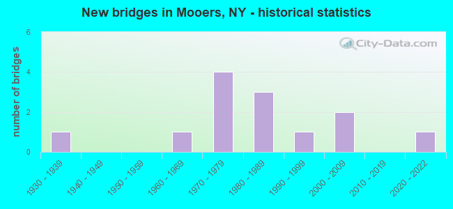
- New bridges - historical statistics
- 11930-1939
- 11960-1969
- 41970-1979
- 31980-1989
- 11990-1999
- 22000-2009
- 12020-2022


- Bridge Condition - Deck
- 8.3%Excellent
- 16.7%Very good
- 33.3%Good
- 16.7%Satisfactory
- 16.7%Fair
- 8.3%Poor

- Bridge Condition - Superstructure
- 8.3%Excellent
- 41.7%Very good
- 25.0%Good
- 16.7%Satisfactory
- 8.3%Fair

- Bridge Condition - Substructure
- 16.7%Excellent
- 33.3%Very good
- 33.3%Good
- 8.3%Satisfactory
- 8.3%Fair

- Bridge Condition - Channel
- 38.5%Very good
- 38.5%Good
- 23.1%Satisfactory
Find on map >> Show street view
Structure Number: 100904, Location: 2.9MI W JCT RTS 11 & 22 (Lat: 44.956544, Lng: -73.641739), Route carried "on" structure: US 11, Year Built: 1989, Status: Open, Structure Length: 6.28m (20.60ft), Average Daily Traffic: 2,143 (year 2018), Truck Traffic: 22%, Average Future Daily Traffic: 2,163 (year 2040), Design Load: HS 20, Features Intersected: N BR GRT CHAZY RV
Minimum Vertical Clearance: 30+ m (98+ ft), Kilometerpoint: 33.709, Lanes on structure: 2, Base Highway Network: Yes, Owner: State Highway Agency, Approaching Roadway Width: 10.4m (34.1ft), Material/Design: Prestressed concrete continuous, Design/Construction: Box Beam or Girders - Multiple, Number Of Spans In Main Unit: 2, Length of Maximum Span: 30.1m (98.8ft), Curb-To-Curb Width: 11.6m (38.1ft), Out-to-Out Width: 12.4m (40.7ft)
Condition: Deck: Fair, Superstructure: Good, Substructure: Good, Channel: Satisfactory, Operating Rating: 81.6 metric tons, Method Used To Determine Operating Rating: Load Factor (LF), Inventory Rating: 29.9 metric tons, Method Used To Determine Inventory Rating: Load Factor (LF), Structural Evaluation: Better than present minimum criteria, Deck Geometry: Somewhat better than minimum adequacy, Waterway Adequacy: Somewhat better than minimum adequacy, Approach Roadway Alignment: Equal to present minimum criteria, Length Of Structure Improvement: 6.27m (20.57ft), Designated Inspection Frequency: Every 24 months, Inspection Date: April 2021, Bridge Improvement Cost: $1,178,000, Roadway Improvement Cost: $690,000, Total Project Cost: $1,868,000 ( Estimate for 2021), Deck Structure Type: Concrete Cast-file-Place, Wearing Surface/Protective System: Wearing Surface: Integral Concrete, Deck Protection: Epoxy Coated Reinforcing
Find on map >> Show street view
Structure Number: 100905, Location: 2.8 MI W JCT RTS 11 +I-87 (Lat: 44.976456, Lng: -73.517158), Route carried "on" structure: US 11, Year Built: 1970, Status: Open, Structure Length: 3.11m (10.20ft), Average Daily Traffic: 3,177 (year 2020), Truck Traffic: 14%, Average Future Daily Traffic: 3,207 (year 2040), Design Load: HS 20, Features Intersected: GREAT CHAZY RIVER
Minimum Vertical Clearance: 30+ m (98+ ft), Kilometerpoint: 44.537, Lanes on structure: 2, Base Highway Network: Yes, Owner: State Highway Agency, Approaching Roadway Width: 14.6m (47.9ft), Skew: 1 degrees, Material/Design: Steel, Design/Construction: Stringer/Multi-beam, Number Of Spans In Main Unit: 1, Length of Maximum Span: 29.5m (96.8ft), Curb-To-Curb Width: 14.3m (46.9ft), Out-to-Out Width: 15.2m (49.9ft)
Condition: Deck: Satisfactory, Superstructure: Very good, Substructure: Good, Channel: Very good, Operating Rating: 98.0 metric tons, Method Used To Determine Operating Rating: Load Factor (LF), Inventory Rating: 59.0 metric tons, Method Used To Determine Inventory Rating: Load Factor (LF), Structural Evaluation: Better than present minimum criteria, Deck Geometry: Superior to present desirable criteria, Waterway Adequacy: Equal to present minimum criteria, Approach Roadway Alignment: Meets minimum limits, Length Of Structure Improvement: 3.10m (10.17ft), Designated Inspection Frequency: Every 24 months, Inspection Date: June 2021, Bridge Improvement Cost: $1,057,000, Roadway Improvement Cost: $619,000, Total Project Cost: $1,676,000 ( Estimate for 2021), Deck Structure Type: Concrete Cast-file-Place, Wearing Surface/Protective System: Wearing Surface: Integral Concrete
Find on map >> Show street view
Structure Number: 100906, Location: 2.4 MI W JCT RTS 11 +I-87 (Lat: 44.976608, Lng: -73.516172), Route carried "on" structure: US 11, Year Built: 1970, Status: Open, Structure Length: 3.11m (10.20ft), Average Daily Traffic: 3,177 (year 2020), Truck Traffic: 14%, Average Future Daily Traffic: 3,207 (year 2040), Design Load: HS 20, Features Intersected: GREAT CHAZY RIVER
Minimum Vertical Clearance: 30+ m (98+ ft), Kilometerpoint: 44.601, Lanes on structure: 2, Base Highway Network: Yes, Owner: State Highway Agency, Approaching Roadway Width: 14.6m (47.9ft), Skew: 1 degrees, Material/Design: Steel, Design/Construction: Stringer/Multi-beam, Number Of Spans In Main Unit: 1, Length of Maximum Span: 29.5m (96.8ft), Curb-To-Curb Width: 14.3m (46.9ft), Out-to-Out Width: 15.2m (49.9ft)
Condition: Deck: Good, Superstructure: Very good, Substructure: Very good, Channel: Very good, Operating Rating: 96.2 metric tons, Method Used To Determine Operating Rating: Load Factor (LF), Inventory Rating: 57.2 metric tons, Method Used To Determine Inventory Rating: Load Factor (LF), Structural Evaluation: Equal to present desirable criteria, Deck Geometry: Superior to present desirable criteria, Waterway Adequacy: Equal to present minimum criteria, Approach Roadway Alignment: Meets minimum limits, Length Of Structure Improvement: 3.10m (10.17ft), Designated Inspection Frequency: Every 24 months, Inspection Date: June 2021, Bridge Improvement Cost: $1,057,000, Roadway Improvement Cost: $619,000, Total Project Cost: $1,676,000 ( Estimate for 2021), Deck Structure Type: Concrete Cast-file-Place, Wearing Surface/Protective System: Wearing Surface: Integral Concrete
Find on map >> Show street view
Structure Number: 10173, Location: 3 MI SE OF MOOERS (Lat: 44.927308, Lng: -73.568544), Route carried "on" structure: State highway 22, Year Built: 1938, Status: Open, Structure Length: 0.79m (2.59ft), Average Daily Traffic: 1,708 (year 2020), Truck Traffic: 9%, Average Future Daily Traffic: 1,781 (year 2040), Design Load: HS 20, Features Intersected: BULLIS BROOK
Minimum Vertical Clearance: 30+ m (98+ ft), Kilometerpoint: 55.398, Lanes on structure: 2, Base Highway Network: Yes, Owner: State Highway Agency, Approaching Roadway Width: 11.0m (36.1ft), Material/Design: Concrete, Design/Construction: Slab, Number Of Spans In Main Unit: 1, Length of Maximum Span: 7.6m (24.9ft), Curb-To-Curb Width: 8.4m (27.6ft), Out-to-Out Width: 9.1m (29.9ft)
Condition: Deck: Good, Superstructure: Satisfactory, Substructure: Satisfactory, Channel: Good, Operating Rating: 39.2 metric tons, Method Used To Determine Operating Rating: Load and Resistance Factor Rating (LRFR) rating reported by rating factor(RF) method using HL-93 loadings, Inventory Rating: 30.5 metric tons, Method Used To Determine Inventory Rating: Load and Resistance Factor Rating (LRFR) rating reported by rating factor(RF) method using HL-93 loadings, Structural Evaluation: Equal to present minimum criteria, Deck Geometry: Meets minimum limits, Waterway Adequacy: Somewhat better than minimum adequacy, Approach Roadway Alignment: Meets minimum limits, Length Of Structure Improvement: 0.79m (2.59ft), Designated Inspection Frequency: Every 24 months, Inspection Date: June 2021, Bridge Improvement Cost: $204,000, Roadway Improvement Cost: $119,000, Total Project Cost: $323,000 ( Estimate for 2021), Deck Structure Type: Concrete Cast-file-Place, Wearing Surface/Protective System: Wearing Surface: Bituminous, Membrane: Other
Find on map >> Show street view
Structure Number: 101731, Location: 0.1 MI S JCT RTS 22 + 11 (Lat: 44.958200, Lng: -73.581089), Route carried "on" structure: State highway 22, Year Built: 1983, Year Reconstructed: 1985, Status: Open, Structure Length: 4.48m (14.70ft), Average Daily Traffic: 1,708 (year 2020), Truck Traffic: 9%, Average Future Daily Traffic: 1,781 (year 2040), Design Load: HS 20, Features Intersected: GREAT CHAZY RIVER
Minimum Vertical Clearance: 30+ m (98+ ft), Kilometerpoint: 59.034, Lanes on structure: 2, Base Highway Network: Yes, Owner: State Highway Agency, Approaching Roadway Width: 10.4m (34.1ft), Material/Design: Steel, Design/Construction: Stringer/Multi-beam, Number Of Spans In Main Unit: 1, Length of Maximum Span: 44.1m (144.7ft), Curb-To-Curb Width: 10.4m (34.1ft), Out-to-Out Width: 11.0m (36.1ft)
Condition: Deck: Very good, Superstructure: Very good, Substructure: Good, Channel: Good, Inventory Rating: 67.1 metric tons, Method Used To Determine Inventory Rating: Load Factor (LF), Structural Evaluation: Better than present minimum criteria, Deck Geometry: Equal to present minimum criteria, Waterway Adequacy: Somewhat better than minimum adequacy, Approach Roadway Alignment: Equal to present desirable criteria, Length Of Structure Improvement: 4.48m (14.70ft), Designated Inspection Frequency: Every 24 months, Inspection Date: August 2021, Bridge Improvement Cost: $1,274,000, Roadway Improvement Cost: $746,000, Total Project Cost: $2,020,000 ( Estimate for 2021), Deck Structure Type: Concrete Cast-file-Place, Wearing Surface/Protective System: Wearing Surface: Integral Concrete, Deck Protection: Epoxy Coated Reinforcing
Find on map >> Show street view
Structure Number: 109408, Location: 1.3 MI NE JCT US 11 & SH (Lat: 44.967792, Lng: -73.561950), Route carried "on" structure: US 11, Year Built: 1972, Status: Open, Structure Length: 0.61m (2.00ft), Average Daily Traffic: 3,177 (year 2020), Truck Traffic: 14%, Average Future Daily Traffic: 3,207 (year 2040), Design Load: HS 20, Features Intersected: SPERRY BROOK
Minimum Vertical Clearance: 30+ m (98+ ft), Kilometerpoint: 40.853, Lanes on structure: 2, Base Highway Network: Yes, Owner: State Highway Agency, Approaching Roadway Width: 14.6m (47.9ft), Skew: 3 degrees, Material/Design: Steel, Design/Construction: Culvert, Number Of Spans In Main Unit: 2, Length of Maximum Span: 2.7m (8.9ft)
Condition: Channel: Good, Culverts: Good, Operating Rating: 74.5 metric tons, Method Used To Determine Operating Rating: Field evaluation and documented engineering judgment, Inventory Rating: 32.7 metric tons, Method Used To Determine Inventory Rating: Field evaluation and documented engineering judgment, Structural Evaluation: Better than present minimum criteria, Waterway Adequacy: Somewhat better than minimum adequacy, Approach Roadway Alignment: Equal to present desirable criteria, Length Of Structure Improvement: 0.60m (1.97ft), Designated Inspection Frequency: Every 24 months, Critical Feature Inspection Frequency: Every 24 months, Inspection Date: November 2020, Critical Feature Inspection Date: November 2020, Bridge Improvement Cost: $179,000, Roadway Improvement Cost: $105,000, Total Project Cost: $283,000 ( Estimate for 2021)
Find on map >> Show street view
Structure Number: 333622, Location: 3 MILES SE OF MOOERS (Lat: 44.936442, Lng: -73.524772), Route carried "on" structure: County highway , Year Built: 1973, Status: Open, Structure Length: 3.26m (10.70ft), Average Daily Traffic: 543 (year 2017), Truck Traffic: 8%, Average Future Daily Traffic: 760 (year 2037), Features Intersected: GREAT CHAZY RIVER, Facility Carried by Structure: LAVALLEY ROAD
Minimum Vertical Clearance: 30+ m (98+ ft), Kilometerpoint: 5.133, Lanes on structure: 2, Owner: County Highway Agency, Approaching Roadway Width: 7.3m (24.0ft), Material/Design: Steel, Design/Construction: Stringer/Multi-beam, Number Of Spans In Main Unit: 1, Length of Maximum Span: 31.3m (102.7ft), Curb or Sidewalk Widths: Left: 0.5m (1.6ft), Right: 0.5m (1.6ft), Curb-To-Curb Width: 7.3m (24.0ft), Out-to-Out Width: 8.3m (27.2ft)
Condition: Deck: Good, Superstructure: Good, Substructure: Very good, Channel: Good, Operating Rating: 92.5 metric tons, Method Used To Determine Operating Rating: Load Factor (LF), Inventory Rating: 55.3 metric tons, Method Used To Determine Inventory Rating: Load Factor (LF), Structural Evaluation: Better than present minimum criteria, Deck Geometry: Meets minimum limits, Waterway Adequacy: Somewhat better than minimum adequacy, Approach Roadway Alignment: Better than present minimum criteria, Length Of Structure Improvement: 3.26m (10.70ft), Designated Inspection Frequency: Every 24 months, Inspection Date: August 2020, Bridge Improvement Cost: $606,000, Roadway Improvement Cost: $355,000, Total Project Cost: $961,000 ( Estimate for 2021), Deck Structure Type: Concrete Cast-file-Place, Wearing Surface/Protective System: Wearing Surface: Bituminous
Find on map >> Show street view
Structure Number: 333623, Location: 2.4 MI SE OF MOOERS (Lat: 44.936569, Lng: -73.537750), Route carried "on" structure: County highway , Year Built: 2007, Status: Open, Structure Length: 3.35m (10.99ft), Average Daily Traffic: 345 (year 2017), Truck Traffic: 4%, Average Future Daily Traffic: 483 (year 2037), Design Load: HS 25 or greater, Features Intersected: GREAT CHAZY RIVER, Facility Carried by Structure: ANGELVILLE ROAD
Minimum Vertical Clearance: 30+ m (98+ ft), Kilometerpoint: 4.457, Lanes on structure: 2, Owner: County Highway Agency, Approaching Roadway Width: 6.1m (20.0ft), Material/Design: Prestressed concrete, Design/Construction: Box Beam or Girders - Multiple, Number Of Spans In Main Unit: 1, Length of Maximum Span: 32.9m (107.9ft), Curb-To-Curb Width: 7.8m (25.6ft), Out-to-Out Width: 9.0m (29.5ft)
Condition: Deck: Very good, Superstructure: Very good, Substructure: Very good, Channel: Very good, Operating Rating: 93.4 metric tons, Method Used To Determine Operating Rating: Load Factor (LF), Inventory Rating: 52.6 metric tons, Method Used To Determine Inventory Rating: Load Factor (LF), Structural Evaluation: Equal to present desirable criteria, Deck Geometry: Somewhat better than minimum adequacy, Waterway Adequacy: Equal to present minimum criteria, Approach Roadway Alignment: Equal to present desirable criteria, Length Of Structure Improvement: 3.35m (10.99ft), Designated Inspection Frequency: Every 24 months, Inspection Date: June 2021, Bridge Improvement Cost: $676,000, Roadway Improvement Cost: $396,000, Total Project Cost: $1,071,000 ( Estimate for 2021), Deck Structure Type: Concrete Cast-file-Place, Wearing Surface/Protective System: Wearing Surface: Integral Concrete, Deck Protection: Epoxy Coated Reinforcing
Find on map >> Show street view
Structure Number: 333626, Location: 1.2 MI W OF MOOERS (Lat: 44.958161, Lng: -73.603983), Route carried "on" structure: Other road , Year Built: 2020, Status: Open, Structure Length: 4.15m (13.62ft), Average Daily Traffic: 393 (year 2015), Truck Traffic: 4%, Average Future Daily Traffic: 550 (year 2035), Design Load: HS 20, Features Intersected: GREAT CHAZY RIVER, Facility Carried by Structure: TAPPIN ROAD
Minimum Vertical Clearance: 30+ m (98+ ft), Kilometerpoint: 1.448, Lanes on structure: 2, Owner: County Highway Agency, Approaching Roadway Width: 7.9m (25.9ft), Skew: 3 degrees, Material/Design: Steel, Design/Construction: Stringer/Multi-beam, Number Of Spans In Main Unit: 1, Length of Maximum Span: 39.6m (129.9ft), Curb-To-Curb Width: 7.9m (25.9ft), Out-to-Out Width: 9.0m (29.5ft)
Condition: Deck: Excellent, Superstructure: Excellent, Substructure: Excellent, Channel: Good, Inventory Rating: 66.2 metric tons, Method Used To Determine Inventory Rating: Load Factor (LF), Structural Evaluation: Superior to present desirable criteria, Deck Geometry: Somewhat better than minimum adequacy, Waterway Adequacy: Meets minimum limits, Approach Roadway Alignment: Equal to present desirable criteria, Length Of Structure Improvement: 4.14m (13.58ft), Designated Inspection Frequency: Every 24 months, Inspection Date: November 2020, Bridge Improvement Cost: $877,000, Roadway Improvement Cost: $514,000, Total Project Cost: $1,391,000 ( Estimate for 2021), Deck Structure Type: Concrete Cast-file-Place, Wearing Surface/Protective System: Wearing Surface: Integral Concrete, Deck Protection: Epoxy Coated Reinforcing
Find on map >> Show street view
Structure Number: 333627, Location: .4 MI E OF MOOERS FORKS (Lat: 44.956614, Lng: -73.632692), Route carried "on" structure: Other road , Year Built: 2002, Status: Open, Structure Length: 3.05m (10.01ft), Average Daily Traffic: 154 (year 2020), Truck Traffic: 4%, Average Future Daily Traffic: 216 (year 2040), Design Load: HS 25 or greater, Features Intersected: GREAT CHAZY RIVER, Facility Carried by Structure: EMERY RD
Minimum Vertical Clearance: 30+ m (98+ ft), Kilometerpoint: 3.315, Lanes on structure: 2, Owner: County Highway Agency, Approaching Roadway Width: 7.3m (24.0ft), Skew: 1 degrees, Material/Design: Prestressed concrete, Design/Construction: Box Beam or Girders - Multiple, Number Of Spans In Main Unit: 1, Length of Maximum Span: 29.6m (97.1ft), Curb-To-Curb Width: 7.3m (24.0ft), Out-to-Out Width: 8.4m (27.6ft)
Condition: Deck: Good, Superstructure: Good, Substructure: Excellent, Channel: Very good, Inventory Rating: 71.7 metric tons, Method Used To Determine Inventory Rating: Load Factor (LF), Structural Evaluation: Better than present minimum criteria, Deck Geometry: Somewhat better than minimum adequacy, Waterway Adequacy: Equal to present minimum criteria, Approach Roadway Alignment: Equal to present desirable criteria, Length Of Structure Improvement: 3.04m (9.97ft), Designated Inspection Frequency: Every 24 months, Inspection Date: October 2020, Bridge Improvement Cost: $470,000, Roadway Improvement Cost: $275,000, Total Project Cost: $745,000 ( Estimate for 2021), Deck Structure Type: Concrete Cast-file-Place, Wearing Surface/Protective System: Wearing Surface: Integral Concrete
Find on map >> Show street view
Structure Number: 33364, Location: 3MILES WEST OF MOOERS (Lat: 44.956386, Lng: -73.639247), Route carried "on" structure: County highway , Year Built: 1989, Status: Open, Structure Length: 3.26m (10.70ft), Average Daily Traffic: 648 (year 2016), Truck Traffic: 8%, Average Future Daily Traffic: 907 (year 2036), Design Load: HS 20, Features Intersected: NBR GREAT CHAZY R, Facility Carried by Structure: CR 16
Minimum Vertical Clearance: 30+ m (98+ ft), Kilometerpoint: 12.727, Lanes on structure: 2, Owner: County Highway Agency, Approaching Roadway Width: 9.1m (29.9ft), Skew: 1 degrees, Material/Design: Prestressed concrete, Design/Construction: Box Beam or Girders - Multiple, Number Of Spans In Main Unit: 1, Length of Maximum Span: 31.3m (102.7ft), Curb-To-Curb Width: 8.5m (27.9ft), Out-to-Out Width: 9.5m (31.2ft)
Condition: Deck: Satisfactory, Superstructure: Satisfactory, Substructure: Good, Channel: Very good, Inventory Rating: 42.6 metric tons, Method Used To Determine Inventory Rating: Load Factor (LF), Structural Evaluation: Equal to present minimum criteria, Deck Geometry: Somewhat better than minimum adequacy, Waterway Adequacy: Better than present minimum criteria, Approach Roadway Alignment: Equal to present desirable criteria, Length Of Structure Improvement: 3.26m (10.70ft), Designated Inspection Frequency: Every 24 months, Inspection Date: July 2020, Bridge Improvement Cost: $517,000, Roadway Improvement Cost: $303,000, Total Project Cost: $820,000 ( Estimate for 2021), Wearing Surface/Protective System: Wearing Surface: Integral Concrete
Find on map >> Show street view
Structure Number: 333643, Location: 3.1 MI NW MOOERS (Lat: 44.975189, Lng: -73.663025), Route carried "on" structure: ServiceCounty highway , Year Built: 1997, Status: Open, Structure Length: 2.74m (8.99ft), Average Daily Traffic: 282 (year 2020), Truck Traffic: 7%, Average Future Daily Traffic: 395 (year 2040), Design Load: HS 25 or greater, Features Intersected: ENGLISH RIVER, Facility Carried by Structure: BUSH ROAD
Minimum Vertical Clearance: 30+ m (98+ ft), Kilometerpoint: 8.029, Lanes on structure: 2, Owner: County Highway Agency, Approaching Roadway Width: 7.3m (24.0ft), Material/Design: Prestressed concrete, Design/Construction: Box Beam or Girders - Multiple, Number Of Spans In Main Unit: 1, Length of Maximum Span: 25.9m (85.0ft), Curb-To-Curb Width: 7.3m (24.0ft), Out-to-Out Width: 7.9m (25.9ft)
Condition: Deck: Fair, Superstructure: Very good, Substructure: Very good, Channel: Satisfactory, Operating Rating: 89.8 metric tons, Method Used To Determine Operating Rating: Load Factor (LF), Inventory Rating: 68.0 metric tons, Method Used To Determine Inventory Rating: Load Factor (LF), Structural Evaluation: Equal to present desirable criteria, Deck Geometry: Somewhat better than minimum adequacy, Waterway Adequacy: Equal to present minimum criteria, Approach Roadway Alignment: Equal to present desirable criteria, Length Of Structure Improvement: 2.74m (8.99ft), Designated Inspection Frequency: Every 24 months, Inspection Date: April 2021, Bridge Improvement Cost: $340,000, Roadway Improvement Cost: $199,000, Total Project Cost: $539,000 ( Estimate for 2021), Deck Structure Type: Concrete Cast-file-Place, Wearing Surface/Protective System: Wearing Surface: Integral Concrete, Deck Protection: Epoxy Coated Reinforcing
Find on map >> Show street view
Structure Number: 333644, Location: 3.4 MI NW OF MOOERS (Lat: 44.996147, Lng: -73.655400), Route carried "on" structure: Other road , Year Built: 1962, Status: Posted for load, Structure Length: 1.34m (4.40ft), Average Daily Traffic: 37 (year 2020), Truck Traffic: 7%, Average Future Daily Traffic: 52 (year 2040), Features Intersected: ENGLISH RIVER, Facility Carried by Structure: SCRIVER ROAD
Minimum Vertical Clearance: 30+ m (98+ ft), Kilometerpoint: 3.990, Lanes on structure: 2, Owner: County Highway Agency, Approaching Roadway Width: 5.8m (19.0ft), Material/Design: Steel, Design/Construction: Stringer/Multi-beam, Number Of Spans In Main Unit: 1, Length of Maximum Span: 11.8m (38.7ft), Curb or Sidewalk Widths: Left: 0.4m (1.3ft), Right: 0.4m (1.3ft), Curb-To-Curb Width: 6.7m (22.0ft), Out-to-Out Width: 8.0m (26.2ft)
Condition: Deck: Poor, Superstructure: Fair, Substructure: Fair, Channel: Satisfactory, Operating Rating: 28.1 metric tons, Method Used To Determine Operating Rating: Load Factor (LF), Inventory Rating: 16.3 metric tons, Method Used To Determine Inventory Rating: Load Factor (LF), Structural Evaluation: Somewhat better than minimum adequacy, Deck Geometry: Somewhat better than minimum adequacy, Waterway Adequacy: Somewhat better than minimum adequacy, Approach Roadway Alignment: Equal to present minimum criteria, Bridge Posting: Required (Relationship of Operating Rating to Maximum Legal Load: > 39.9% below), Length Of Structure Improvement: 1.34m (4.40ft), Designated Inspection Frequency: Every 12 months, Inspection Date: July 2021, Bridge Improvement Cost: $376,000, Roadway Improvement Cost: $220,000, Total Project Cost: $596,000 ( Estimate for 2021), Deck Structure Type: Concrete Cast-file-Place, Wearing Surface/Protective System: Wearing Surface: Bituminous