Bridge Statistics for Mooringsport, Louisiana (LA)
Condition, Traffic, Stress, Structural Evaluation, Project Costs
- National Bridge Inventory (NBI) Statistics
- 12Number of bridges
- 299ft / 90.7mTotal length
- $6,553,000Total costs
- 15,844Total average daily traffic
- 3,734Total average daily truck traffic
- 19,791Total future (year 2036) average daily traffic
- National Bridge Inventory (NBI) Registered Bridges for Mooringsport
- No street view available for this location
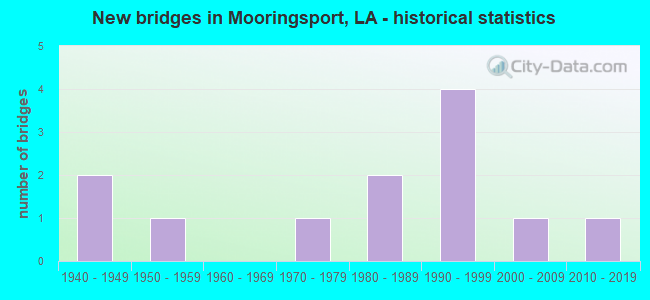
- New bridges - historical statistics
- 21940-1949
- 11950-1959
- 11970-1979
- 21980-1989
- 41990-1999
- 12000-2009
- 12010-2019


- Bridge Condition - Deck
- 10.0%Very good
- 20.0%Good
- 40.0%Satisfactory
- 10.0%Poor
- 10.0%Serious
- 10.0%Failed

- Bridge Condition - Superstructure
- 10.0%Very good
- 20.0%Good
- 40.0%Satisfactory
- 10.0%Poor
- 10.0%Serious
- 10.0%Failed

- Bridge Condition - Substructure
- 10.0%Very good
- 10.0%Good
- 30.0%Satisfactory
- 10.0%Fair
- 10.0%Poor
- 20.0%Serious
- 10.0%Failed

- Bridge Condition - Channel
- 33.3%Very good
- 25.0%Good
- 25.0%Satisfactory
- 16.7%Fair

- Bridge Condition - Culverts
- 50.0%Satisfactory
- 50.0%Fair
Find on map >> Show street view
Structure Number: 40900000040332, Location: 3.3 MI. E. OF LA 1 (Lat: 32.702011, Lng: -93.906600), Route carried "on" structure: State highway 169, Year Built: 2013, Status: Open, Structure Length: 4.88m (16.01ft), Average Daily Traffic: 280 (year 2016), Truck Traffic: 19%, Average Future Daily Traffic: 330 (year 2036), Design Load: HS 20, Features Intersected: SODA LAKE CANAL
Minimum Vertical Clearance: 30+ m (98+ ft), Kilometerpoint: 5.575, Lanes on structure: 2, Owner: State Highway Agency, Approaching Roadway Width: 8.5m (27.9ft), Skew: 30 degrees, Material/Design: Prestressed concrete continuous, Design/Construction: Stringer/Multi-beam, Number Of Spans In Main Unit: 4, Length of Maximum Span: 12.2m (40.0ft), Curb-To-Curb Width: 9.6m (31.5ft), Out-to-Out Width: 10.5m (34.4ft)
Condition: Deck: Very good, Superstructure: Very good, Substructure: Very good, Channel: Very good, Operating Rating: 62.9 metric tons, Method Used To Determine Operating Rating: Load and Resistance Factor Rating (LRFR) rating reported by rating factor(RF) method using HL-93 loadings, Inventory Rating: 41.1 metric tons, Method Used To Determine Inventory Rating: Load and Resistance Factor Rating (LRFR) rating reported by rating factor(RF) method using HL-93 loadings, Structural Evaluation: Equal to present desirable criteria, Deck Geometry: Equal to present minimum criteria, Waterway Adequacy: Equal to present desirable criteria, Approach Roadway Alignment: Equal to present desirable criteria, Designated Inspection Frequency: Every 24 months, Underwater Inspection Frequency: Every 60 months, Inspection Date: January 2021, Underwater Inspection Date: July 2020, Deck Structure Type: Concrete Cast-file-Place, Wearing Surface/Protective System: Wearing Surface: Monolithic Concrete
Find on map >> Show street view
Structure Number: 40900450112421, Location: .9 MI NORTH OF LA 169 (Lat: 32.702761, Lng: -93.945300), Route carried "on" structure: State highway 1, Year Built: 1940, Status: Closed, Structure Length: 29.47m (96.69ft), Average Daily Traffic: 5,400 (year 2016), Truck Traffic: 26%, Average Future Daily Traffic: 6,490 (year 2036), Design Load: H 15, Features Intersected: CADDO LAKE
Minimum Vertical Clearance: 30+ m (98+ ft), Kilometerpoint: 20.073, Lanes on structure: 2, Base Highway Network: Yes (Inventory Route: 45-01-1, Subroute: 10), Owner: State Highway Agency, Approaching Roadway Width: 12.2m (40.0ft), Material/Design: Steel, Design/Construction: Truss - Thru, Number Of Spans In Main Unit: 9, Number Of Approach Spans: 4, Length of Maximum Span: 30.5m (100.1ft), Curb-To-Curb Width: 7.3m (24.0ft), Out-to-Out Width: 8.7m (28.5ft)
Condition: Deck: Failed, Superstructure: Failed, Substructure: Failed, Channel: Very good, Operating Rating: 18.8 metric tons, Method Used To Determine Operating Rating: Load and Resistance Factor Rating (LRFR) rating reported by rating factor(RF) method using HL-93 loadings, Inventory Rating: 14.6 metric tons, Method Used To Determine Inventory Rating: Load and Resistance Factor Rating (LRFR) rating reported by rating factor(RF) method using HL-93 loadings, Waterway Adequacy: Equal to present desirable criteria, Approach Roadway Alignment: Equal to present minimum criteria, Bridge Posting: Required (Relationship of Operating Rating to Maximum Legal Load: > 39.9% below), Length Of Structure Improvement: 29.66m (97.31ft), Designated Inspection Frequency: Every 24 months, Critical Feature Inspection Frequency: Every 24 months, Underwater Inspection Frequency: Every 60 months, Other Special Inspection Frequency: Every 6 months, Inspection Date: December 2021, Critical Feature Inspection Date: January 2020, Underwater Inspection Date: May 2018, Other Special Inspection Date: June 2021, Bridge Improvement Cost: $2,529,000, Total Project Cost: $3,793,000 ( Estimate for 2016), Deck Structure Type: Concrete Cast-file-Place
Find on map >> Show street view
Structure Number: 40900450113531, Location: 0.2 MI SOUTH OF LA 538 (Lat: 32.716889, Lng: -93.953100), Route carried "on" structure: State highway 1, Year Built: 1940, Status: Open, Structure Length: 0.70m (2.30ft), Average Daily Traffic: 5,400 (year 2016), Truck Traffic: 26%, Average Future Daily Traffic: 6,490 (year 2036), Design Load: H 15, Features Intersected: CREEK
Minimum Vertical Clearance: 30+ m (98+ ft), Kilometerpoint: 0.377, Lanes on structure: 2, Base Highway Network: Yes (Inventory Route: 45-01-2, Subroute: 10), Owner: State Highway Agency, Approaching Roadway Width: 12.2m (40.0ft), Material/Design: Concrete, Design/Construction: Culvert, Number Of Spans In Main Unit: 2, Length of Maximum Span: 3.0m (9.8ft), Curb-To-Curb Width: 11.6m (38.1ft), Out-to-Out Width: 12.2m (40.0ft)
Condition: Channel: Fair, Culverts: Satisfactory, Operating Rating: 42.1 metric tons, Method Used To Determine Operating Rating: Load and Resistance Factor Rating (LRFR) rating reported by rating factor(RF) method using HL-93 loadings, Inventory Rating: 32.4 metric tons, Method Used To Determine Inventory Rating: Load and Resistance Factor Rating (LRFR) rating reported by rating factor(RF) method using HL-93 loadings, Structural Evaluation: Equal to present minimum criteria, Deck Geometry: Somewhat better than minimum adequacy, Waterway Adequacy: Equal to present desirable criteria, Approach Roadway Alignment: Equal to present desirable criteria, Designated Inspection Frequency: Every 24 months, Inspection Date: January 2022, Deck Structure Type: Concrete Cast-file-Place
Find on map >> Show street view
Structure Number: 40900453101051, Location: 0.8 MI EAST OF LA 538 (Lat: 32.690119, Lng: -93.944500), Route carried "on" structure: State highway 169, Year Built: 1970, Status: Open, Structure Length: 3.47m (11.38ft), Average Daily Traffic: 280 (year 2016), Truck Traffic: 19%, Average Future Daily Traffic: 330 (year 2036), Design Load: HS 20, Features Intersected: WALNUT BAYOU
Minimum Vertical Clearance: 30+ m (98+ ft), Kilometerpoint: 1.370, Lanes on structure: 2, Owner: State Highway Agency, Approaching Roadway Width: 11.3m (37.1ft), Material/Design: Concrete, Design/Construction: Slab, Number Of Spans In Main Unit: 6, Length of Maximum Span: 5.8m (19.0ft), Curb-To-Curb Width: 8.6m (28.2ft), Out-to-Out Width: 9.4m (30.8ft)
Condition: Deck: Poor, Superstructure: Poor, Substructure: Poor, Channel: Good, Operating Rating: 63.5 metric tons, Method Used To Determine Operating Rating: Load Factor (LF), Inventory Rating: 38.1 metric tons, Method Used To Determine Inventory Rating: Load Factor (LF), Structural Evaluation: Meets minimum limits, Deck Geometry: Equal to present minimum criteria, Waterway Adequacy: Equal to present minimum criteria, Approach Roadway Alignment: Equal to present desirable criteria, Length Of Structure Improvement: 4.36m (14.30ft), Designated Inspection Frequency: Every 24 months, Underwater Inspection Frequency: Every 60 months, Other Special Inspection Frequency: Every 12 months, Inspection Date: January 2022, Underwater Inspection Date: July 2020, Other Special Inspection Date: January 2021, Bridge Improvement Cost: $371,000, Total Project Cost: $556,000 ( Estimate for 2016), Deck Structure Type: Concrete Precast Panels, Wearing Surface/Protective System: Wearing Surface: Bituminous
Find on map >> Show street view
Structure Number: 40900453103201, Location: 1.6 MI EAST OF LA 1 (Lat: 32.699681, Lng: -93.911400), Route carried "on" structure: State highway 169, Year Built: 1955, Status: Posted for load, Structure Length: 15.00m (49.21ft), Average Daily Traffic: 280 (year 2016), Truck Traffic: 19%, Average Future Daily Traffic: 330 (year 2036), Design Load: H 15, Features Intersected: TWELVE MILE BAYOU
Minimum Vertical Clearance: 30+ m (98+ ft), Kilometerpoint: 5.047, Lanes on structure: 2, Owner: State Highway Agency, Approaching Roadway Width: 12.2m (40.0ft), Material/Design: Steel, Design/Construction: Stringer/Multi-beam, Number Of Spans In Main Unit: 10, Length of Maximum Span: 21.3m (69.9ft), Curb-To-Curb Width: 7.3m (24.0ft), Out-to-Out Width: 9.0m (29.5ft)
Condition: Deck: Serious, Superstructure: Serious, Substructure: Serious, Channel: Fair, Operating Rating: 22.7 metric tons, Method Used To Determine Operating Rating: Load and Resistance Factor Rating (LRFR) rating reported by rating factor(RF) method using HL-93 loadings, Inventory Rating: 17.5 metric tons, Method Used To Determine Inventory Rating: Load and Resistance Factor Rating (LRFR) rating reported by rating factor(RF) method using HL-93 loadings, Structural Evaluation: High priority of corrective action, Deck Geometry: Somewhat better than minimum adequacy, Waterway Adequacy: Equal to present desirable criteria, Approach Roadway Alignment: Equal to present desirable criteria, Bridge Posting: Required (Relationship of Operating Rating to Maximum Legal Load: 20.0 - 29.9% below), Length Of Structure Improvement: 15.91m (52.20ft), Designated Inspection Frequency: Every 24 months, Underwater Inspection Frequency: Every 60 months, Other Special Inspection Frequency: Every 12 months, Inspection Date: January 2021, Underwater Inspection Date: November 2021, Other Special Inspection Date: January 2022, Bridge Improvement Cost: $1,357,000, Total Project Cost: $2,035,000 ( Estimate for 2016), Deck Structure Type: Concrete Cast-file-Place
Find on map >> Show street view
Structure Number: 40900780300341, Location: .34 MI NORTH OF LA 767 (Lat: 32.695569, Lng: -93.957300), Route carried "on" structure: State highway 538, Year Built: 1994, Status: Open, Structure Length: 25.91m (85.01ft), Average Daily Traffic: 1,360 (year 2016), Truck Traffic: 19%, Average Future Daily Traffic: 1,604 (year 2036), Design Load: HS 20, Features Intersected: CADDO LAKE
Minimum Vertical Clearance: 30+ m (98+ ft), Kilometerpoint: 0.525, Lanes on structure: 2, Owner: State Highway Agency, Approaching Roadway Width: 12.2m (40.0ft), Material/Design: Steel, Design/Construction: Girder and Floorbeam System, Number Of Spans In Main Unit: 1, Number Of Approach Spans: 15, Length of Maximum Span: 30.5m (100.1ft), Curb-To-Curb Width: 12.3m (40.4ft), Out-to-Out Width: 13.1m (43.0ft)
Condition: Deck: Satisfactory, Superstructure: Satisfactory, Substructure: Good, Channel: Very good, Operating Rating: 55.3 metric tons, Method Used To Determine Operating Rating: Load Factor (LF), Inventory Rating: 33.6 metric tons, Method Used To Determine Inventory Rating: Load Factor (LF), Structural Evaluation: Equal to present minimum criteria, Deck Geometry: Better than present minimum criteria, Waterway Adequacy: Superior to present desirable criteria, Approach Roadway Alignment: Equal to present minimum criteria, Designated Inspection Frequency: Every 24 months, Underwater Inspection Frequency: Every 60 months, Inspection Date: June 2021, Underwater Inspection Date: June 2021, Deck Structure Type: Concrete Cast-file-Place
Find on map >> Show street view
Structure Number: 40900780302021, Location: 2.02 MI NORTH OF LA 767 (Lat: 32.715969, Lng: -93.954900), Route carried "on" structure: State highway 538, Year Built: 1980, Status: Open, Structure Length: 1.16m (3.81ft), Average Daily Traffic: 1,410 (year 2016), Truck Traffic: 19%, Average Future Daily Traffic: 1,675 (year 2036), Design Load: HS 20, Features Intersected: CREEK
Minimum Vertical Clearance: 30+ m (98+ ft), Kilometerpoint: 2.908, Lanes on structure: 2, Owner: State Highway Agency, Approaching Roadway Width: 11.6m (38.1ft), Material/Design: Concrete, Design/Construction: Slab, Number Of Spans In Main Unit: 2, Length of Maximum Span: 5.8m (19.0ft), Curb-To-Curb Width: 9.8m (32.2ft), Out-to-Out Width: 10.7m (35.1ft)
Condition: Deck: Satisfactory, Superstructure: Satisfactory, Substructure: Satisfactory, Channel: Good, Operating Rating: 65.3 metric tons, Method Used To Determine Operating Rating: Load Factor (LF), Inventory Rating: 39.0 metric tons, Method Used To Determine Inventory Rating: Load Factor (LF), Structural Evaluation: Equal to present minimum criteria, Deck Geometry: Somewhat better than minimum adequacy, Waterway Adequacy: Equal to present desirable criteria, Approach Roadway Alignment: Equal to present desirable criteria, Designated Inspection Frequency: Every 24 months, Inspection Date: January 2022, Deck Structure Type: Concrete Precast Panels
Find on map >> Show street view
Structure Number: 40900780411311, Location: 5.40 MI N OF LA 173 (Lat: 32.672269, Lng: -93.953500), Route carried "on" structure: State highway 538, Year Built: 1998, Status: Open, Structure Length: 4.63m (15.19ft), Average Daily Traffic: 640 (year 2016), Truck Traffic: 19%, Average Future Daily Traffic: 778 (year 2036), Design Load: HS 20, Features Intersected: WALNUT BAYOU
Minimum Vertical Clearance: 30+ m (98+ ft), Kilometerpoint: 18.157, Lanes on structure: 2, Owner: State Highway Agency, Approaching Roadway Width: 9.4m (30.8ft), Material/Design: Concrete, Design/Construction: Slab, Number Of Spans In Main Unit: 8, Length of Maximum Span: 5.8m (19.0ft), Curb-To-Curb Width: 9.8m (32.2ft), Out-to-Out Width: 10.7m (35.1ft)
Condition: Deck: Good, Superstructure: Good, Substructure: Satisfactory, Channel: Satisfactory, Operating Rating: 63.5 metric tons, Method Used To Determine Operating Rating: Load Factor (LF), Inventory Rating: 38.1 metric tons, Method Used To Determine Inventory Rating: Load Factor (LF), Structural Evaluation: Equal to present minimum criteria, Deck Geometry: Equal to present minimum criteria, Waterway Adequacy: Equal to present desirable criteria, Approach Roadway Alignment: Equal to present desirable criteria, Designated Inspection Frequency: Every 24 months, Inspection Date: January 2021, Deck Structure Type: Concrete Precast Panels, Wearing Surface/Protective System: Wearing Surface: Bituminous
Find on map >> Show street view
Structure Number: 40900780411551, Location: 5.64 MI N OF LA 173 (Lat: 32.676050, Lng: -93.954500), Route carried "on" structure: State highway 538, Year Built: 1998, Status: Open, Structure Length: 0.73m (2.40ft), Average Daily Traffic: 640 (year 2016), Truck Traffic: 19%, Average Future Daily Traffic: 778 (year 2036), Design Load: HS 20, Features Intersected: CREEK
Minimum Vertical Clearance: 30+ m (98+ ft), Kilometerpoint: 18.585, Lanes on structure: 2, Owner: State Highway Agency, Approaching Roadway Width: 9.1m (29.9ft), Material/Design: Steel, Design/Construction: Culvert, Number Of Spans In Main Unit: 3, Length of Maximum Span: 1.8m (5.9ft), Curb-To-Curb Width: 9.0m (29.5ft), Out-to-Out Width: 18.6m (61.0ft)
Condition: Channel: Good, Culverts: Fair, Operating Rating: 97.2 metric tons, Method Used To Determine Operating Rating: Load and Resistance Factor Rating (LRFR) rating reported by rating factor(RF) method using HL-93 loadings, Inventory Rating: 74.5 metric tons, Method Used To Determine Inventory Rating: Load and Resistance Factor Rating (LRFR) rating reported by rating factor(RF) method using HL-93 loadings, Structural Evaluation: Somewhat better than minimum adequacy, Deck Geometry: Somewhat better than minimum adequacy, Waterway Adequacy: Equal to present minimum criteria, Approach Roadway Alignment: Equal to present desirable criteria, Designated Inspection Frequency: Every 24 months, Inspection Date: January 2021
Find on map >> Show street view
Structure Number: 40932314935851, Location: 0.1 MI EAST OF LA 538 (Lat: 32.667650, Lng: -93.951019), Route carried "on" structure: County highway , Year Built: 1983, Status: Posted for load, Structure Length: 1.22m (4.00ft), Average Daily Traffic: 40 (year 2019), Average Future Daily Traffic: 94 (year 2036), Design Load: HS 20, Features Intersected: TRIBUTARY TO WALNUT B., Facility Carried by Structure: Barnette Road
Minimum Vertical Clearance: 30+ m (98+ ft), Kilometerpoint: 0.000, Lanes on structure: 2, Owner: County Highway Agency, Approaching Roadway Width: 8.5m (27.9ft), Material/Design: Concrete, Design/Construction: Slab, Number Of Spans In Main Unit: 2, Length of Maximum Span: 5.8m (19.0ft), Curb-To-Curb Width: 8.6m (28.2ft), Out-to-Out Width: 9.6m (31.5ft)
Condition: Deck: Satisfactory, Superstructure: Satisfactory, Substructure: Serious, Channel: Satisfactory, Operating Rating: 23.0 metric tons, Method Used To Determine Operating Rating: Load and Resistance Factor Rating (LRFR) rating reported by rating factor(RF) method using HL-93 loadings, Inventory Rating: 17.8 metric tons, Method Used To Determine Inventory Rating: Load and Resistance Factor Rating (LRFR) rating reported by rating factor(RF) method using HL-93 loadings, Structural Evaluation: High priority of corrective action, Deck Geometry: Better than present minimum criteria, Waterway Adequacy: Somewhat better than minimum adequacy, Approach Roadway Alignment: Equal to present desirable criteria, Length Of Structure Improvement: 1.89m (6.20ft), Designated Inspection Frequency: Every 24 months, Other Special Inspection Frequency: Every 12 months, Inspection Date: March 2021, Other Special Inspection Date: March 2020, Bridge Improvement Cost: $113,000, Total Project Cost: $169,000 ( Estimate for 2016), Deck Structure Type: Concrete Precast Panels
Find on map >> Show street view
Structure Number: 40932387935981, Location: 0.4 MI NORTH OF CADDO 130 (Lat: 32.645569, Lng: -93.996339), Route carried "on" structure: County highway , Year Built: 2000, Status: Posted for load, Structure Length: 1.74m (5.71ft), Average Daily Traffic: 57 (year 2019), Average Future Daily Traffic: 446 (year 2036), Design Load: HS 20, Features Intersected: MILLER BRANCH, Facility Carried by Structure: Old Moorings-Latex
Minimum Vertical Clearance: 30+ m (98+ ft), Kilometerpoint: 0.000, Lanes on structure: 2, Base Highway Network: Yes, Owner: County Highway Agency, Approaching Roadway Width: 6.7m (22.0ft), Material/Design: Concrete, Design/Construction: Slab, Number Of Spans In Main Unit: 3, Length of Maximum Span: 5.8m (19.0ft), Curb-To-Curb Width: 8.6m (28.2ft), Out-to-Out Width: 9.4m (30.8ft)
Condition: Deck: Satisfactory, Superstructure: Satisfactory, Substructure: Fair, Channel: Very good, Operating Rating: 17.8 metric tons, Method Used To Determine Operating Rating: Load and Resistance Factor Rating (LRFR) rating reported by rating factor(RF) method using HL-93 loadings, Inventory Rating: 13.6 metric tons, Method Used To Determine Inventory Rating: Load and Resistance Factor Rating (LRFR) rating reported by rating factor(RF) method using HL-93 loadings, Structural Evaluation: Meets minimum limits, Deck Geometry: Better than present minimum criteria, Waterway Adequacy: Equal to present minimum criteria, Approach Roadway Alignment: Equal to present minimum criteria, Bridge Posting: Required (Relationship of Operating Rating to Maximum Legal Load: 30.0 - 39.9% below), Designated Inspection Frequency: Every 24 months, Other Special Inspection Frequency: Every 12 months, Inspection Date: March 2021, Deck Structure Type: Concrete Precast Panels
Find on map >> Show street view
Structure Number: 40932398935881, Location: 0.4 MI SW OF LA 169 (Lat: 32.663511, Lng: -93.981561), Route carried "on" structure: County highway , Year Built: 1996, Status: Open, Structure Length: 1.74m (5.71ft), Average Daily Traffic: 57 (year 2019), Average Future Daily Traffic: 446 (year 2036), Design Load: HS 20, Features Intersected: TETE BAYOU, Facility Carried by Structure: Old Moorings-Latex
Minimum Vertical Clearance: 30+ m (98+ ft), Kilometerpoint: 0.000, Lanes on structure: 2, Base Highway Network: Yes, Owner: County Highway Agency, Approaching Roadway Width: 10.1m (33.1ft), Material/Design: Concrete, Design/Construction: Slab, Number Of Spans In Main Unit: 3, Length of Maximum Span: 5.8m (19.0ft), Curb-To-Curb Width: 8.6m (28.2ft), Out-to-Out Width: 9.5m (31.2ft)
Condition: Deck: Good, Superstructure: Good, Substructure: Satisfactory, Channel: Satisfactory, Operating Rating: 27.2 metric tons, Method Used To Determine Operating Rating: Load and Resistance Factor Rating (LRFR) rating reported by rating factor(RF) method using HL-93 loadings, Inventory Rating: 21.1 metric tons, Method Used To Determine Inventory Rating: Load and Resistance Factor Rating (LRFR) rating reported by rating factor(RF) method using HL-93 loadings, Structural Evaluation: Equal to present minimum criteria, Deck Geometry: Better than present minimum criteria, Waterway Adequacy: Equal to present desirable criteria, Approach Roadway Alignment: Equal to present desirable criteria, Designated Inspection Frequency: Every 24 months, Inspection Date: March 2021, Deck Structure Type: Concrete Precast Panels