Bridge Statistics for Moreau, New York (NY)
Condition, Traffic, Stress, Structural Evaluation, Project Costs
- National Bridge Inventory (NBI) Statistics
- 16Number of bridges
- 440ft / 134mTotal length
- $69,189,000Total costs
- 144,622Total average daily traffic
- 6,563Total average daily truck traffic
- National Bridge Inventory (NBI) Registered Bridges for Moreau
- No street view available for this location
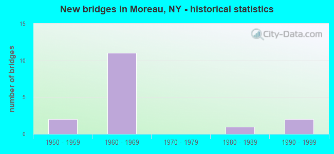
- New bridges - historical statistics
- 21950-1959
- 111960-1969
- 11980-1989
- 21990-1999
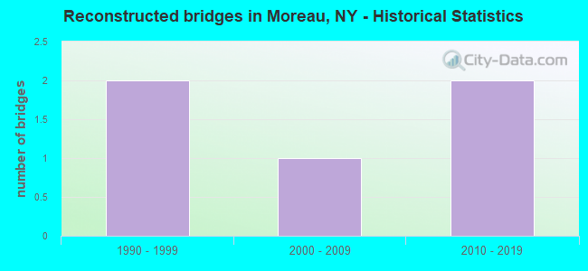
- Reconstructed bridges - Historical Statistics
- 21990-1999
- 12000-2009
- 22010-2019
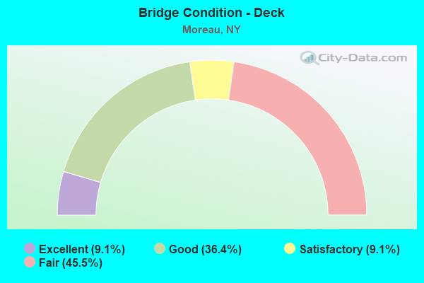
- Bridge Condition - Deck
- 9.1%Excellent
- 36.4%Good
- 9.1%Satisfactory
- 45.5%Fair
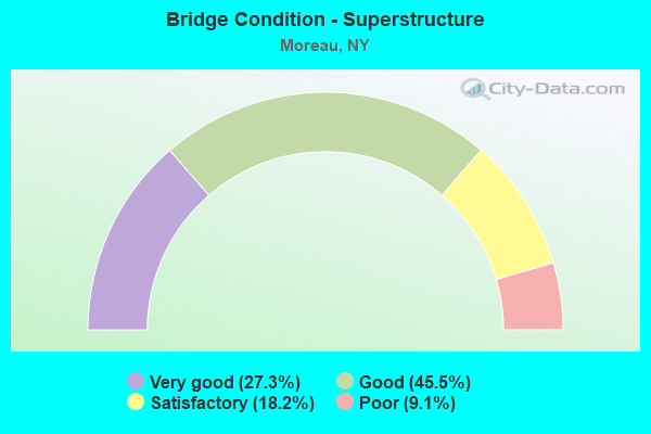
- Bridge Condition - Superstructure
- 27.3%Very good
- 45.5%Good
- 18.2%Satisfactory
- 9.1%Poor
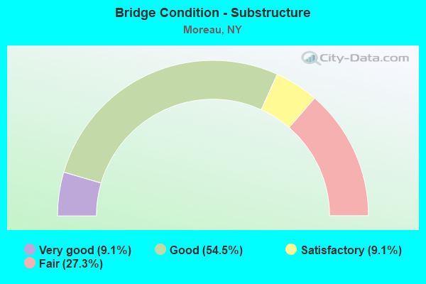
- Bridge Condition - Substructure
- 9.1%Very good
- 54.5%Good
- 9.1%Satisfactory
- 27.3%Fair
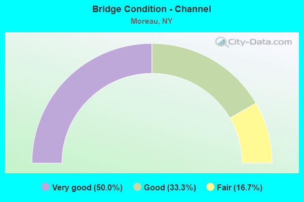
- Bridge Condition - Channel
- 50.0%Very good
- 33.3%Good
- 16.7%Fair
Find on map >> Show street view
Structure Number: 1005679, Location: JCT RTE 9 & I87 (Lat: 43.235658, Lng: -73.692078), Route carried "on" structure: US 9, Year Built: 1958, Status: Open, Structure Length: 11.40m (37.40ft), Average Daily Traffic: 15,927 (year 2018), Truck Traffic: 8%, Average Future Daily Traffic: 16,001 (year 2040), Design Load: H 20, Features Intersected: I-87-SB, RTE I87
Minimum Vertical Clearance: 30+ m (98+ ft), Kilometerpoint: 50.330, Lanes on structure: 4, Lanes under structure: 8, Base Highway Network: Yes, Owner: State Highway Agency, Approaching Roadway Width: 12.2m (40.0ft), Skew: 24 degrees, Material/Design: Steel, Design/Construction: Stringer/Multi-beam, Number Of Spans In Main Unit: 5, Length of Maximum Span: 27.4m (89.9ft), Curb-To-Curb Width: 29.9m (98.1ft), Out-to-Out Width: 31.5m (103.3ft)
Condition: Deck: Fair, Superstructure: Poor, Substructure: Fair, Operating Rating: 50.8 metric tons, Method Used To Determine Operating Rating: Load Factor (LF), Inventory Rating: 29.9 metric tons, Method Used To Determine Inventory Rating: Load Factor (LF), Structural Evaluation: Meets minimum limits, Deck Geometry: Superior to present desirable criteria, Underclear: High priority of corrective action, Approach Roadway Alignment: Equal to present desirable criteria, Length Of Structure Improvement: 11.39m (37.37ft), Designated Inspection Frequency: Every 24 months, Inspection Date: July 2021, Bridge Improvement Cost: $7,534,000, Roadway Improvement Cost: $4,412,000, Total Project Cost: $11,945,000 ( Estimate for 2021), Deck Structure Type: Concrete Cast-file-Place, Wearing Surface/Protective System: Wearing Surface: Integral Concrete
Find on map >> Show street view
Structure Number: 103341, Location: 1.2 M S JCT I87 & RTE 9 (Lat: 43.217797, Lng: -73.692569), Route carried "on" structure: Other road , Year Built: 1962, Year Reconstructed: 2010, Status: Open, Structure Length: 10.21m (33.50ft), Average Daily Traffic: 315 (year 2017), Truck Traffic: 9%, Average Future Daily Traffic: 441 (year 2037), Design Load: H 20, Features Intersected: 87I 87I15091313 NB, RTE, Facility Carried by Structure: OLD WEST ROAD
Minimum Vertical Clearance: 30+ m (98+ ft), Kilometerpoint: 1.625, Lanes on structure: 2, Lanes under structure: 6, Owner: State Highway Agency, Approaching Roadway Width: 9.8m (32.2ft), Material/Design: Steel, Design/Construction: Stringer/Multi-beam, Number Of Spans In Main Unit: 6, Length of Maximum Span: 20.7m (67.9ft), Curb or Sidewalk Widths: Left: 0.5m (1.6ft), Right: 0.5m (1.6ft), Curb-To-Curb Width: 9.2m (30.2ft), Out-to-Out Width: 10.8m (35.4ft)
Condition: Deck: Good, Superstructure: Good, Substructure: Good, Operating Rating: 60.8 metric tons, Method Used To Determine Operating Rating: Load Factor (LF), Inventory Rating: 36.3 metric tons, Method Used To Determine Inventory Rating: Load Factor (LF), Structural Evaluation: Better than present minimum criteria, Deck Geometry: Equal to present minimum criteria, Underclear: Meets minimum limits, Approach Roadway Alignment: Equal to present desirable criteria, Length Of Structure Improvement: 10.21m (33.50ft), Designated Inspection Frequency: Every 24 months, Inspection Date: May 2021, Bridge Improvement Cost: $2,222,000, Roadway Improvement Cost: $1,301,000, Total Project Cost: $3,523,000 ( Estimate for 2021), Deck Structure Type: Concrete Cast-file-Place, Wearing Surface/Protective System: Wearing Surface: Monolithic Concrete
Find on map >> Show street view
Structure Number: 103342, Location: 0.45 M N JCT I87 & RTE 9 (Lat: 43.242111, Lng: -73.692106), Route carried "on" structure: County highway , Year Built: 1960, Status: Open, Structure Length: 4.33m (14.21ft), Average Daily Traffic: 2,259 (year 2019), Truck Traffic: 8%, Average Future Daily Traffic: 2,795 (year 2040), Design Load: H 20, Features Intersected: RTE I87, Facility Carried by Structure: SPIER FALLS ROAD
Minimum Vertical Clearance: 30+ m (98+ ft), Kilometerpoint: 14.996, Lanes on structure: 2, Lanes under structure: 3, Owner: State Highway Agency, Approaching Roadway Width: 9.1m (29.9ft), Skew: 1 degrees, Material/Design: Steel, Design/Construction: Stringer/Multi-beam, Number Of Spans In Main Unit: 3, Length of Maximum Span: 17.3m (56.8ft), Curb or Sidewalk Widths: Left: 0.5m (1.6ft), Right: 0.5m (1.6ft), Curb-To-Curb Width: 9.2m (30.2ft), Out-to-Out Width: 10.7m (35.1ft)
Condition: Deck: Fair, Superstructure: Good, Substructure: Fair, Operating Rating: 68.9 metric tons, Method Used To Determine Operating Rating: Load Factor (LF), Inventory Rating: 40.8 metric tons, Method Used To Determine Inventory Rating: Load Factor (LF), Structural Evaluation: Somewhat better than minimum adequacy, Deck Geometry: Meets minimum limits, Underclear: High priority of corrective action, Approach Roadway Alignment: Equal to present desirable criteria, Length Of Structure Improvement: 4.32m (14.17ft), Designated Inspection Frequency: Every 24 months, Inspection Date: April 2021, Bridge Improvement Cost: $1,045,000, Roadway Improvement Cost: $612,000, Total Project Cost: $1,656,000 ( Estimate for 2021), Deck Structure Type: Concrete Cast-file-Place, Wearing Surface/Protective System: Wearing Surface: Integral Concrete
Find on map >> Show street view
Structure Number: 103343, Location: .4 MI S JCT I87 & HUD RVR (Lat: 43.259083, Lng: -73.678822), Route carried "on" structure: Other road , Year Built: 1960, Year Reconstructed: 2019, Status: Open, Structure Length: 7.77m (25.49ft), Average Daily Traffic: 934 (year 2020), Truck Traffic: 4%, Average Future Daily Traffic: 1,155 (year 2040), Design Load: H 20, Features Intersected: 87I 87I15091342 NB, RTE, Facility Carried by Structure: BUTLER ROAD
Minimum Vertical Clearance: 30+ m (98+ ft), Kilometerpoint: 1.689, Lanes on structure: 2, Lanes under structure: 6, Owner: State Highway Agency, Approaching Roadway Width: 9.2m (30.2ft), Material/Design: Steel, Design/Construction: Stringer/Multi-beam, Number Of Spans In Main Unit: 4, Length of Maximum Span: 19.5m (64.0ft), Curb or Sidewalk Widths: Left: 0.5m (1.6ft), Right: 0.5m (1.6ft), Curb-To-Curb Width: 9.2m (30.2ft), Out-to-Out Width: 10.7m (35.1ft)
Condition: Deck: Good, Superstructure: Good, Substructure: Good, Operating Rating: 59.9 metric tons, Method Used To Determine Operating Rating: Load Factor (LF), Inventory Rating: 35.4 metric tons, Method Used To Determine Inventory Rating: Load Factor (LF), Structural Evaluation: Better than present minimum criteria, Deck Geometry: Equal to present minimum criteria, Underclear: Meets minimum limits, Approach Roadway Alignment: Equal to present desirable criteria, Length Of Structure Improvement: 7.77m (25.49ft), Designated Inspection Frequency: Every 24 months, Inspection Date: April 2021, Bridge Improvement Cost: $1,729,000, Roadway Improvement Cost: $1,013,000, Total Project Cost: $2,742,000 ( Estimate for 2021), Deck Structure Type: Concrete Cast-file-Place, Wearing Surface/Protective System: Wearing Surface: Integral Concrete
Find on map >> Show street view
Structure Number: 1033441, Location: 2 Mi. N I-87 EXIT 17 (Lat: 43.262981, Lng: -73.676964), Route carried "on" structure: Interstate 87, Year Built: 1960, Year Reconstructed: 1997, Status: Open, Structure Length: 22.25m (73.00ft), Average Daily Traffic: 19,734 (year 2002), Truck Traffic: 9%, Design Load: HS 25 or greater, Features Intersected: HUDSON RIVER
Minimum Vertical Clearance: 30+ m (98+ ft), Kilometerpoint: 55.511, Lanes on structure: 3, Base Highway Network: Yes, Owner: State Highway Agency, Approaching Roadway Width: 19.2m (63.0ft), Material/Design: Steel continuous, Design/Construction: Stringer/Multi-beam, Number Of Spans In Main Unit: 5, Length of Maximum Span: 67.0m (219.8ft), Curb-To-Curb Width: 19.1m (62.7ft), Out-to-Out Width: 19.7m (64.6ft)
Condition: Deck: Fair, Superstructure: Very good, Substructure: Good, Channel: Very good, Operating Rating: 89.8 metric tons, Method Used To Determine Operating Rating: Load Factor (LF), Inventory Rating: 55.3 metric tons, Method Used To Determine Inventory Rating: Load Factor (LF), Structural Evaluation: Better than present minimum criteria, Deck Geometry: Superior to present desirable criteria, Waterway Adequacy: Superior to present desirable criteria, Approach Roadway Alignment: Equal to present desirable criteria, Length Of Structure Improvement: 22.25m (73.00ft), Designated Inspection Frequency: Every 24 months, Underwater Inspection Frequency: Every 60 months, Inspection Date: July 2021, Underwater Inspection Date: August 2019, Bridge Improvement Cost: $8,944,000, Roadway Improvement Cost: $5,237,000, Total Project Cost: $14,181,000 ( Estimate for 2021), Deck Structure Type: Concrete Cast-file-Place, Wearing Surface/Protective System: Wearing Surface: Integral Concrete, Deck Protection: Epoxy Coated Reinforcing
Find on map >> Show street view
Structure Number: 1033442, Location: 2 Mi. N I-87 EXIT 17 (Lat: 43.264075, Lng: -73.676072), Route carried "on" structure: Interstate 87, Year Built: 1960, Year Reconstructed: 1998, Status: Open, Structure Length: 22.37m (73.39ft), Average Daily Traffic: 16,527 (year 2018), Truck Traffic: 11%, Average Future Daily Traffic: 26,189 (year 2040), Design Load: HS 25 or greater, Features Intersected: HUDSON RIVER
Minimum Vertical Clearance: 30+ m (98+ ft), Kilometerpoint: 0.000, Lanes on structure: 3, Base Highway Network: Yes, Owner: State Highway Agency, Approaching Roadway Width: 19.2m (63.0ft), Material/Design: Steel continuous, Design/Construction: Stringer/Multi-beam, Number Of Spans In Main Unit: 5, Length of Maximum Span: 67.0m (219.8ft), Curb-To-Curb Width: 19.1m (62.7ft), Out-to-Out Width: 19.7m (64.6ft)
Condition: Deck: Fair, Superstructure: Very good, Substructure: Good, Channel: Very good, Operating Rating: 89.8 metric tons, Method Used To Determine Operating Rating: Load Factor (LF), Inventory Rating: 55.3 metric tons, Method Used To Determine Inventory Rating: Load Factor (LF), Structural Evaluation: Better than present minimum criteria, Deck Geometry: Superior to present desirable criteria, Waterway Adequacy: Superior to present desirable criteria, Approach Roadway Alignment: Equal to present desirable criteria, Length Of Structure Improvement: 22.37m (73.39ft), Designated Inspection Frequency: Every 24 months, Underwater Inspection Frequency: Every 60 months, Inspection Date: July 2021, Underwater Inspection Date: August 2019, Bridge Improvement Cost: $8,990,000, Roadway Improvement Cost: $5,264,000, Total Project Cost: $14,254,000 ( Estimate for 2021), Deck Structure Type: Concrete Cast-file-Place, Wearing Surface/Protective System: Wearing Surface: Integral Concrete, Deck Protection: Epoxy Coated Reinforcing
Find on map >> Show street view
Structure Number: 103984, Location: JCT SH 197 & HUDSON RIVER (Lat: 43.264206, Lng: -73.590925), Route carried "on" structure: State highway 197, Year Built: 1963, Year Reconstructed: 2014, Status: Open, Structure Length: 15.64m (51.31ft), Average Daily Traffic: 10,851 (year 2020), Truck Traffic: 10%, Average Future Daily Traffic: 10,901 (year 2040), Design Load: HS 20, Features Intersected: HUDSON RIVER
Minimum Vertical Clearance: 30+ m (98+ ft), Kilometerpoint: 0.000, Lanes on structure: 2, Base Highway Network: Yes, Owner: State Highway Agency, Approaching Roadway Width: 8.5m (27.9ft), Material/Design: Steel, Design/Construction: Stringer/Multi-beam, Number Of Spans In Main Unit: 5, Length of Maximum Span: 30.4m (99.7ft), Curb or Sidewalk Widths: Left: 0.5m (1.6ft), Right: 0.5m (1.6ft), Curb-To-Curb Width: 8.6m (28.2ft), Out-to-Out Width: 10.1m (33.1ft)
Condition: Deck: Good, Superstructure: Satisfactory, Substructure: Good, Channel: Good, Operating Rating: 89.8 metric tons, Method Used To Determine Operating Rating: Load Factor (LF), Inventory Rating: 53.5 metric tons, Method Used To Determine Inventory Rating: Load Factor (LF), Structural Evaluation: Equal to present minimum criteria, Deck Geometry: Meets minimum limits, Waterway Adequacy: Superior to present desirable criteria, Approach Roadway Alignment: Equal to present desirable criteria, Length Of Structure Improvement: 15.63m (51.28ft), Designated Inspection Frequency: Every 24 months, Underwater Inspection Frequency: Every 60 months, Inspection Date: June 2020, Underwater Inspection Date: July 2017, Bridge Improvement Cost: $3,209,000, Roadway Improvement Cost: $1,879,000, Total Project Cost: $5,087,000 ( Estimate for 2021), Deck Structure Type: Concrete Cast-file-Place, Wearing Surface/Protective System: Wearing Surface: Integral Concrete
Find on map >> Show street view
Structure Number: 109585, Location: .2 MI N OF I87 EXIT 17 (Lat: 43.242147, Lng: -73.691292), Route carried "on" structure: County highway , Year Built: 1960, Status: Open, Structure Length: 4.48m (14.70ft), Average Daily Traffic: 2,259 (year 2019), Truck Traffic: 8%, Average Future Daily Traffic: 2,795 (year 2040), Design Load: H 20, Features Intersected: RTE I87, Facility Carried by Structure: SPIER FALLS ROAD
Minimum Vertical Clearance: 30+ m (98+ ft), Kilometerpoint: 15.060, Lanes on structure: 2, Lanes under structure: 3, Owner: State Highway Agency, Approaching Roadway Width: 10.4m (34.1ft), Skew: 1 degrees, Material/Design: Steel, Design/Construction: Stringer/Multi-beam, Number Of Spans In Main Unit: 3, Length of Maximum Span: 20.1m (65.9ft), Curb or Sidewalk Widths: Left: 0.5m (1.6ft), Right: 0.5m (1.6ft), Curb-To-Curb Width: 9.2m (30.2ft), Out-to-Out Width: 10.7m (35.1ft)
Condition: Deck: Satisfactory, Superstructure: Good, Substructure: Fair, Operating Rating: 35.6 metric tons, Method Used To Determine Operating Rating: Load and Resistance Factor Rating (LRFR) rating reported by rating factor(RF) method using HL-93 loadings, Inventory Rating: 25.9 metric tons, Method Used To Determine Inventory Rating: Load and Resistance Factor Rating (LRFR) rating reported by rating factor(RF) method using HL-93 loadings, Structural Evaluation: Somewhat better than minimum adequacy, Deck Geometry: Meets minimum limits, Underclear: High priority of corrective action, Approach Roadway Alignment: Equal to present minimum criteria, Length Of Structure Improvement: 4.48m (14.70ft), Designated Inspection Frequency: Every 24 months, Inspection Date: April 2021, Bridge Improvement Cost: $1,089,000, Roadway Improvement Cost: $638,000, Total Project Cost: $1,727,000 ( Estimate for 2021), Deck Structure Type: Concrete Cast-file-Place, Wearing Surface/Protective System: Wearing Surface: Integral Concrete
Find on map >> Show street view
Structure Number: 330413, Location: 2.8 MI SE JCT SH 197 & 32 (Lat: 43.224792, Lng: -73.608419), Route carried "on" structure: County highway , Year Built: 1993, Status: Open, Structure Length: 1.65m (5.41ft), Average Daily Traffic: 191 (year 2018), Truck Traffic: 5%, Average Future Daily Traffic: 267 (year 2038), Design Load: HS 25 or greater, Features Intersected: SNOOK KILL, Facility Carried by Structure: CLARK ROAD
Minimum Vertical Clearance: 30+ m (98+ ft), Kilometerpoint: 5.776, Lanes on structure: 2, Owner: County Highway Agency, Approaching Roadway Width: 7.0m (23.0ft), Skew: 1 degrees, Material/Design: Prestressed concrete, Design/Construction: Box Beam or Girders - Multiple, Number Of Spans In Main Unit: 1, Length of Maximum Span: 15.2m (49.9ft), Curb-To-Curb Width: 6.9m (22.6ft), Out-to-Out Width: 7.7m (25.3ft)
Condition: Deck: Fair, Superstructure: Satisfactory, Substructure: Satisfactory, Channel: Fair, Operating Rating: 48.0 metric tons, Method Used To Determine Operating Rating: Load and Resistance Factor Rating (LRFR) rating reported by rating factor(RF) method using HL-93 loadings, Inventory Rating: 32.4 metric tons, Method Used To Determine Inventory Rating: Load and Resistance Factor Rating (LRFR) rating reported by rating factor(RF) method using HL-93 loadings, Structural Evaluation: Equal to present minimum criteria, Deck Geometry: Meets minimum limits, Waterway Adequacy: Equal to present desirable criteria, Approach Roadway Alignment: Better than present minimum criteria, Length Of Structure Improvement: 1.64m (5.38ft), Designated Inspection Frequency: Every 24 months, Inspection Date: March 2020, Bridge Improvement Cost: $1,041,000, Roadway Improvement Cost: $610,000, Total Project Cost: $1,651,000 ( Estimate for 2021), Deck Structure Type: Concrete Cast-file-Place, Wearing Surface/Protective System: Wearing Surface: Bituminous, Membrane: Other, Deck Protection: Epoxy Coated Reinforcing
Find on map >> Show street view
Structure Number: 330414, Location: 4 MI.NE GANSEVOORT (Lat: 43.230644, Lng: -73.593269), Route carried "on" structure: County highway , Year Built: 1988, Status: Open, Structure Length: 2.29m (7.51ft), Average Daily Traffic: 792 (year 2017), Truck Traffic: 7%, Average Future Daily Traffic: 1,109 (year 2037), Design Load: HS 20, Features Intersected: SNOOK KILL, Facility Carried by Structure: CR29 RIVER ROAD
Minimum Vertical Clearance: 30+ m (98+ ft), Kilometerpoint: 12.325, Lanes on structure: 2, Owner: County Highway Agency, Approaching Roadway Width: 6.1m (20.0ft), Material/Design: Prestressed concrete, Design/Construction: Box Beam or Girders - Multiple, Number Of Spans In Main Unit: 1, Length of Maximum Span: 21.3m (69.9ft), Curb-To-Curb Width: 8.2m (26.9ft), Out-to-Out Width: 8.9m (29.2ft)
Condition: Deck: Excellent, Superstructure: Very good, Substructure: Good, Channel: Very good, Operating Rating: 61.6 metric tons, Method Used To Determine Operating Rating: Load and Resistance Factor Rating (LRFR) rating reported by rating factor(RF) method using HL-93 loadings, Inventory Rating: 43.7 metric tons, Method Used To Determine Inventory Rating: Load and Resistance Factor Rating (LRFR) rating reported by rating factor(RF) method using HL-93 loadings, Structural Evaluation: Better than present minimum criteria, Deck Geometry: Somewhat better than minimum adequacy, Waterway Adequacy: Equal to present desirable criteria, Approach Roadway Alignment: Better than present minimum criteria, Length Of Structure Improvement: 2.28m (7.48ft), Designated Inspection Frequency: Every 24 months, Inspection Date: March 2020, Bridge Improvement Cost: $1,122,000, Roadway Improvement Cost: $657,000, Total Project Cost: $1,780,000 ( Estimate for 2021), Deck Structure Type: Concrete Cast-file-Place, Wearing Surface/Protective System: Wearing Surface: Bituminous, Membrane: Preformed Fabric, Deck Protection: Epoxy Coated Reinforcing
Find on map >> Show street view
Structure Number: 336829, Location: .25 MI W OF HUDSON FALLS (Lat: 43.297994, Lng: -73.591314), Route carried "on" structure: County highway , Year Built: 1993, Status: Open, Structure Length: 31.73m (104.10ft), Average Daily Traffic: 4,073 (year 2017), Truck Traffic: 3%, Average Future Daily Traffic: 4,947 (year 2040), Design Load: HS 20, Features Intersected: HUDSON RIVER, Facility Carried by Structure: COUNTY ROAD 27
Minimum Vertical Clearance: 30+ m (98+ ft), Kilometerpoint: 5.744, Lanes on structure: 2, Owner: County Highway Agency, Approaching Roadway Width: 8.5m (27.9ft), Material/Design: Steel continuous, Design/Construction: Stringer/Multi-beam, Number Of Spans In Main Unit: 7, Length of Maximum Span: 54.8m (179.8ft), Curb or Sidewalk Widths: Left: 0.0m, Right: 1.5m (4.9ft), Curb-To-Curb Width: 8.5m (27.9ft), Out-to-Out Width: 10.7m (35.1ft)
Condition: Deck: Good, Superstructure: Good, Substructure: Very good, Channel: Good, Operating Rating: 68.9 metric tons, Method Used To Determine Operating Rating: Load Factor (LF), Inventory Rating: 38.1 metric tons, Method Used To Determine Inventory Rating: Load Factor (LF), Structural Evaluation: Better than present minimum criteria, Deck Geometry: Meets minimum limits, Waterway Adequacy: Equal to present minimum criteria, Approach Roadway Alignment: Equal to present desirable criteria, Length Of Structure Improvement: 31.72m (104.07ft), Designated Inspection Frequency: Every 24 months, Underwater Inspection Frequency: Every 60 months, Inspection Date: April 2021, Underwater Inspection Date: August 2018, Bridge Improvement Cost: $6,712,000, Roadway Improvement Cost: $3,931,000, Total Project Cost: $10,643,000 ( Estimate for 2021), Deck Structure Type: Concrete Cast-file-Place, Wearing Surface/Protective System: Wearing Surface: Integral Concrete, Deck Protection: Epoxy Coated Reinforcing
Find on map >> Show street view
Structure Number: 1005679, Location: JCT RTE 9 & I87 (Lat: 43.235658, Lng: -73.692078), Route carried "under" structure: Interstate 87, Year Built: 1958, Structure Length: 0. m, Average Daily Traffic: 14,152 (year 2000), Features Intersected: I-87-SB, RTE I87, Facility Carried by Structure: RTE 9
Minimum Vertical Clearance: 4.50m (14.76ft), Kilometerpoint: 52.293, Lanes on structure: 4, Lanes under structure: 4, Material/Design: Steel, Design/Construction: Stringer/Multi-beam, Length of Maximum Span: 27.4m (89.9ft)
Find on map >> Show street view
Structure Number: 103341, Location: 1.2 M S JCT I87 & RTE 9 (Lat: 43.217797, Lng: -73.692569), Route carried "under" structure: Interstate 87, Year Built: 1962, Structure Length: 0. m, Average Daily Traffic: 14,152 (year 2000), Features Intersected: 87I 87I15091313 NB, RTE, Facility Carried by Structure: OLD WEST ROAD
Minimum Vertical Clearance: 5.03m (16.50ft), Kilometerpoint: 50.330, Lanes on structure: 2, Lanes under structure: 3, Material/Design: Steel, Design/Construction: Stringer/Multi-beam, Length of Maximum Span: 20.7m (67.9ft)
Find on map >> Show street view
Structure Number: 103342, Location: 0.45 M N JCT I87 & RTE 9 (Lat: 43.242111, Lng: -73.692106), Route carried "under" structure: Interstate 87, Year Built: 1960, Structure Length: 0. m, Average Daily Traffic: 14,152 (year 2000), Features Intersected: RTE I87, Facility Carried by Structure: SPIER FALLS ROAD
Minimum Vertical Clearance: 4.85m (15.91ft), Kilometerpoint: 53.017, Lanes on structure: 2, Lanes under structure: 3, Material/Design: Steel, Design/Construction: Stringer/Multi-beam, Length of Maximum Span: 17.3m (56.8ft)
Find on map >> Show street view
Structure Number: 103343, Location: .4 MI S JCT I87 & HUD RVR (Lat: 43.259083, Lng: -73.678822), Route carried "under" structure: Interstate 87, Year Built: 1960, Structure Length: 0. m, Average Daily Traffic: 14,152 (year 2000), Features Intersected: 87I 87I15091342 NB, RTE, Facility Carried by Structure: BUTLER ROAD
Minimum Vertical Clearance: 5.63m (18.47ft), Kilometerpoint: 55.221, Lanes on structure: 2, Lanes under structure: 3, Material/Design: Steel, Design/Construction: Stringer/Multi-beam, Length of Maximum Span: 19.5m (64.0ft)
Find on map >> Show street view
Structure Number: 109585, Location: .2 MI N OF I87 EXIT 17 (Lat: 43.242147, Lng: -73.691292), Route carried "under" structure: Interstate 87, Year Built: 1960, Structure Length: 0. m, Average Daily Traffic: 14,152 (year 2000), Features Intersected: RTE I87, Facility Carried by Structure: SPIER FALLS ROAD
Minimum Vertical Clearance: 4.64m (15.22ft), Kilometerpoint: 55.221, Lanes on structure: 2, Lanes under structure: 3, Material/Design: Steel, Design/Construction: Stringer/Multi-beam, Length of Maximum Span: 20.1m (65.9ft)