Bridge Statistics for Morgan City, Louisiana (LA)
Condition, Traffic, Stress, Structural Evaluation, Project Costs
- National Bridge Inventory (NBI) Statistics
- 24Number of bridges
- 2,356ft / 718mTotal length
- $1,461,000Total costs
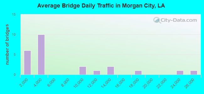
- 151,914Total average daily traffic
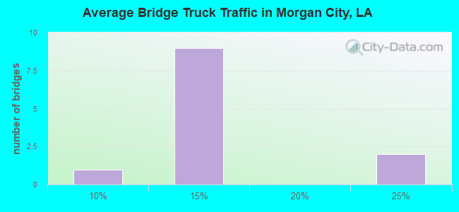
- 15,221Total average daily truck traffic
- National Bridge Inventory (NBI) Registered Bridges for Morgan City
- No street view available for this location
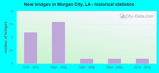
- New bridges - historical statistics
- 61970-1979
- 81980-1989
- 11990-1999
- 12000-2009
- 12010-2019
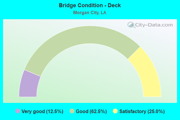
- Bridge Condition - Deck
- 12.5%Very good
- 62.5%Good
- 25.0%Satisfactory
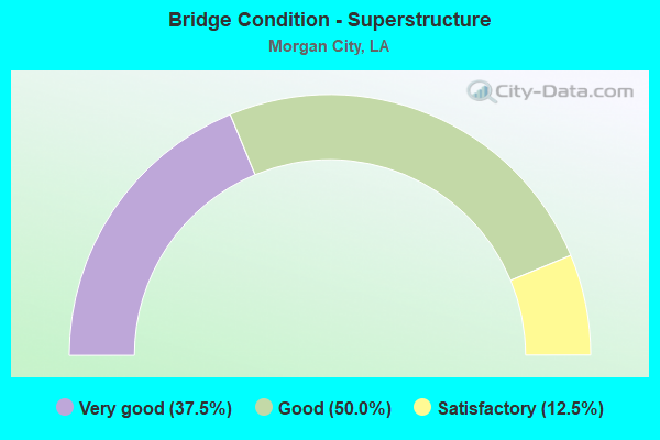
- Bridge Condition - Superstructure
- 37.5%Very good
- 50.0%Good
- 12.5%Satisfactory
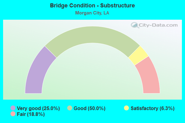
- Bridge Condition - Substructure
- 25.0%Very good
- 50.0%Good
- 6.3%Satisfactory
- 18.8%Fair
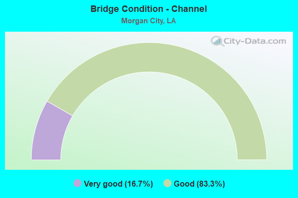
- Bridge Condition - Channel
- 16.7%Very good
- 83.3%Good
Find on map >> Show street view
Structure Number: 35029468910991, Location: 1.4 Mi NE of La 70 (Lat: 29.780150, Lng: -91.167389), Route carried "on" structure: County highway , Year Built: 2001, Status: Open, Structure Length: 11.16m (36.61ft), Average Daily Traffic: 1,800 (year 2001), Average Future Daily Traffic: 1,080 (year 2036), Design Load: HS 20, Features Intersected: MILHOMME BAYOU, Facility Carried by Structure: E Stephenville Rd
Minimum Vertical Clearance: 5.66m (18.57ft), Kilometerpoint: 0.000, Lanes on structure: 2, Owner: County Highway Agency, Approaching Roadway Width: 9.1m (29.9ft), Navigation Control: Yes ( Vertical Clearance: 304.5m (999.0ft), Horizontal Clearance: 38.1m (125.0ft)), Material/Design: Steel, Design/Construction: Movable - Swing, Number Of Spans In Main Unit: 7, Length of Maximum Span: 73.2m (240.2ft), Curb-To-Curb Width: 9.1m (29.9ft), Out-to-Out Width: 10.0m (32.8ft)
Condition: Deck: Satisfactory, Superstructure: Good, Substructure: Good, Channel: Good, Operating Rating: 28.8 metric tons, Method Used To Determine Operating Rating: Load and Resistance Factor Rating (LRFR) rating reported by rating factor(RF) method using HL-93 loadings, Inventory Rating: 22.4 metric tons, Method Used To Determine Inventory Rating: Load and Resistance Factor Rating (LRFR) rating reported by rating factor(RF) method using HL-93 loadings, Structural Evaluation: Somewhat better than minimum adequacy, Deck Geometry: Somewhat better than minimum adequacy, Waterway Adequacy: Equal to present desirable criteria, Approach Roadway Alignment: High priority of corrective action, Length Of Structure Improvement: 12.07m (39.60ft), Designated Inspection Frequency: Every 24 months, Critical Feature Inspection Frequency: Every 24 months, Underwater Inspection Frequency: Every 60 months, Inspection Date: October 2020, Critical Feature Inspection Date: October 2020, Underwater Inspection Date: January 2019, Bridge Improvement Cost: $772,000, Total Project Cost: $1,158,000 ( Estimate for 2016), Deck Structure Type: Open Grating
Find on map >> Show street view
Structure Number: 35100000030507, Location: 4.6 MI W OF LA 83 (Lat: 29.865319, Lng: -91.630919), Route carried "on" structure: US 90, Year Built: 2017, Status: Open, Structure Length: 57.52m (188.71ft), Average Daily Traffic: 11,470 (year 2015), Truck Traffic: 24%, Average Future Daily Traffic: 17,045 (year 2035), Design Load: Greater than HL93, Features Intersected: LA 318
Minimum Vertical Clearance: 30+ m (98+ ft), Kilometerpoint: 59.990, Lanes on structure: 2, Lanes under structure: 2, Base Highway Network: Yes (Inventory Route: 455-05-2, Subroute: 10), Owner: State Highway Agency, Approaching Roadway Width: 12.8m (42.0ft), Material/Design: Concrete continuous, Design/Construction: Stringer/Multi-beam, Number Of Spans In Main Unit: 17, Length of Maximum Span: 33.8m (110.9ft), Curb-To-Curb Width: 12.8m (42.0ft), Out-to-Out Width: 13.4m (44.0ft)
Condition: Deck: Very good, Superstructure: Very good, Substructure: Good, Operating Rating: 72.3 metric tons, Method Used To Determine Operating Rating: Load and Resistance Factor Rating (LRFR) rating reported by rating factor(RF) method using HL-93 loadings, Inventory Rating: 46.0 metric tons, Method Used To Determine Inventory Rating: Load and Resistance Factor Rating (LRFR) rating reported by rating factor(RF) method using HL-93 loadings, Structural Evaluation: Better than present minimum criteria, Deck Geometry: Equal to present desirable criteria, Underclear: Superior to present desirable criteria, Approach Roadway Alignment: Equal to present desirable criteria, Designated Inspection Frequency: Every 24 months, Inspection Date: August 2021, Deck Structure Type: Concrete Cast-file-Place
Find on map >> Show street view
Structure Number: 35100050103901, Location: 2.5 MI EAST OF US90 (Lat: 29.689661, Lng: -91.161600), Route carried "on" structure: US 90, Year Built: 1997, Status: Open, Structure Length: 52.88m (173.49ft), Average Daily Traffic: 8,000 (year 2016), Truck Traffic: 9%, Average Future Daily Traffic: 13,260 (year 2036), Design Load: HS 20, Features Intersected: SOUTHERN PACIFIC RAILROA
Minimum Vertical Clearance: 30+ m (98+ ft), Kilometerpoint: 6.175, Lanes on structure: 4, Lanes under structure: 2, Owner: State Highway Agency, Approaching Roadway Width: 9.8m (32.2ft), Material/Design: Prestressed concrete, Design/Construction: Stringer/Multi-beam, Number Of Spans In Main Unit: 31, Length of Maximum Span: 53.3m (174.9ft), Curb-To-Curb Width: 21.3m (69.9ft), Out-to-Out Width: 22.2m (72.8ft)
Condition: Deck: Good, Superstructure: Good, Substructure: Good, Operating Rating: 58.0 metric tons, Method Used To Determine Operating Rating: Load Factor (LF), Inventory Rating: 34.5 metric tons, Method Used To Determine Inventory Rating: Load Factor (LF), Structural Evaluation: Better than present minimum criteria, Deck Geometry: Superior to present desirable criteria, Approach Roadway Alignment: Equal to present desirable criteria, Designated Inspection Frequency: Every 24 months, Inspection Date: March 2020, Deck Structure Type: Concrete Cast-file-Place
Find on map >> Show street view
Structure Number: 35104240500801, Location: 1.3 MI EAST OF LA 671 (Lat: 29.881531, Lng: -91.664181), Route carried "on" structure: US 90, Year Built: 1973, Status: Open, Structure Length: 0.61m (2.00ft), Average Daily Traffic: 22,400 (year 2016), Truck Traffic: 24%, Average Future Daily Traffic: 36,550 (year 2035), Design Load: HS 20, Features Intersected: DRAIN
Minimum Vertical Clearance: 30+ m (98+ ft), Kilometerpoint: 1.228, Lanes on structure: 8, Base Highway Network: Yes (Inventory Route: 424-05-1, Subroute: 10), Owner: State Highway Agency, Approaching Roadway Width: 40.2m (131.9ft), Skew: 10 degrees, Material/Design: Concrete, Design/Construction: Culvert, Number Of Spans In Main Unit: 3, Length of Maximum Span: 1.8m (5.9ft), Curb-To-Curb Width: 23.2m (76.1ft), Out-to-Out Width: 97.8m (320.9ft)
Condition: Channel: Good, Culverts: Satisfactory, Operating Rating: 42.1 metric tons, Method Used To Determine Operating Rating: Load and Resistance Factor Rating (LRFR) rating reported by rating factor(RF) method using HL-93 loadings, Inventory Rating: 32.4 metric tons, Method Used To Determine Inventory Rating: Load and Resistance Factor Rating (LRFR) rating reported by rating factor(RF) method using HL-93 loadings, Structural Evaluation: Equal to present minimum criteria, Deck Geometry: High priority of replacement, Waterway Adequacy: Better than present minimum criteria, Approach Roadway Alignment: Equal to present desirable criteria, Length Of Structure Improvement: 1.25m (4.10ft), Designated Inspection Frequency: Every 24 months, Inspection Date: November 2021, Bridge Improvement Cost: $202,000, Roadway Improvement Cost: $20,000, Total Project Cost: $303,000 ( Estimate for 2015), Deck Structure Type: Concrete Cast-file-Place
Find on map >> Show street view
Structure Number: 35104240533051, Location: INT OF US 90 AND LA 70 (Lat: 29.696861, Lng: -91.210881), Route carried "on" structure: US 90, Year Built: 1977, Year Reconstructed: 1994, Status: Open, Structure Length: 431.63m (1416.11ft), Average Daily Traffic: 25,700 (year 2016), Truck Traffic: 14%, Average Future Daily Traffic: 57,460 (year 2035), Design Load: HS 20, Features Intersected: ATCHAFALAYA R/US90/LA70
Minimum Vertical Clearance: 30+ m (98+ ft), Kilometerpoint: 53.713, Lanes on structure: 4, Lanes under structure: 6, Base Highway Network: Yes (Inventory Route: 424-05-1, Subroute: 10), Owner: State Highway Agency, Approaching Roadway Width: 10.4m (34.1ft), Skew: 39 degrees, Material/Design: Steel, Design/Construction: Stringer/Multi-beam, Number Of Spans In Main Unit: 6, Number Of Approach Spans: 183, Length of Maximum Span: 51.8m (169.9ft), Curb-To-Curb Width: 20.7m (67.9ft), Out-to-Out Width: 22.3m (73.2ft)
Condition: Deck: Satisfactory, Superstructure: Good, Substructure: Good, Operating Rating: 64.4 metric tons, Method Used To Determine Operating Rating: Load Factor (LF), Inventory Rating: 31.7 metric tons, Method Used To Determine Inventory Rating: Load Factor (LF), Structural Evaluation: Better than present minimum criteria, Deck Geometry: Equal to present minimum criteria, Underclear: Equal to present minimum criteria, Approach Roadway Alignment: Equal to present desirable criteria, Designated Inspection Frequency: Every 24 months, Critical Feature Inspection Frequency: Every 24 months, Inspection Date: March 2020, Critical Feature Inspection Date: March 2020, Deck Structure Type: Concrete Cast-file-Place
Find on map >> Show street view
Structure Number: 35104240533606, Location: INT OF US 90 AND LA 70 (Lat: 29.700100, Lng: -91.202981), Route carried "on" structure: Ramp US 90, Year Built: 1977, Status: Open, Structure Length: 18.62m (61.09ft), Average Daily Traffic: 2,300 (year 2016), Truck Traffic: 14%, Average Future Daily Traffic: 5,746 (year 2035), Design Load: HS 20, Features Intersected: RAMP G
Minimum Vertical Clearance: 30+ m (98+ ft), Kilometerpoint: 0.069, Lanes on structure: 1, Lanes under structure: 1, Owner: State Highway Agency, Approaching Roadway Width: 7.6m (24.9ft), Material/Design: Prestressed concrete, Design/Construction: Stringer/Multi-beam, Number Of Spans In Main Unit: 8, Length of Maximum Span: 30.5m (100.1ft), Curb-To-Curb Width: 7.6m (24.9ft), Out-to-Out Width: 8.5m (27.9ft)
Condition: Deck: Good, Superstructure: Good, Substructure: Good, Operating Rating: 56.2 metric tons, Method Used To Determine Operating Rating: Load Factor (LF), Inventory Rating: 33.6 metric tons, Method Used To Determine Inventory Rating: Load Factor (LF), Structural Evaluation: Better than present minimum criteria, Deck Geometry: Better than present minimum criteria, Underclear: High priority of corrective action, Approach Roadway Alignment: Equal to present desirable criteria, Designated Inspection Frequency: Every 24 months, Inspection Date: August 2021, Deck Structure Type: Concrete Cast-file-Place
Find on map >> Show street view
Structure Number: 35104240533607, Location: INT OF US 90 AND LA 70 (Lat: 29.699789, Lng: -91.202750), Route carried "on" structure: Ramp US 90, Year Built: 1977, Status: Open, Structure Length: 22.19m (72.80ft), Average Daily Traffic: 3,460 (year 2016), Truck Traffic: 14%, Average Future Daily Traffic: 5,746 (year 2035), Design Load: HS 20, Features Intersected: RAMP H
Minimum Vertical Clearance: 30+ m (98+ ft), Kilometerpoint: 0.179, Lanes on structure: 1, Lanes under structure: 1, Owner: State Highway Agency, Approaching Roadway Width: 7.9m (25.9ft), Material/Design: Prestressed concrete, Design/Construction: Stringer/Multi-beam, Number Of Spans In Main Unit: 10, Length of Maximum Span: 30.2m (99.1ft), Curb-To-Curb Width: 7.7m (25.3ft), Out-to-Out Width: 8.5m (27.9ft)
Condition: Deck: Good, Superstructure: Good, Substructure: Good, Operating Rating: 78.9 metric tons, Method Used To Determine Operating Rating: Load Factor (LF), Inventory Rating: 37.2 metric tons, Method Used To Determine Inventory Rating: Load Factor (LF), Structural Evaluation: Better than present minimum criteria, Deck Geometry: Better than present minimum criteria, Approach Roadway Alignment: Equal to present desirable criteria, Designated Inspection Frequency: Every 24 months, Inspection Date: August 2021, Deck Structure Type: Concrete Cast-file-Place
Find on map >> Show street view
Structure Number: 35104240533885, Location: 0.09 MI E of LA 182 (Lat: 29.700550, Lng: -91.198189), Route carried "on" structure: Ramp US 90, Year Built: 1984, Status: Open, Structure Length: 21.40m (70.21ft), Average Daily Traffic: 2,300 (year 2016), Truck Traffic: 14%, Average Future Daily Traffic: 5,746 (year 2035), Design Load: HS 20, Features Intersected: RAMP J
Minimum Vertical Clearance: 30+ m (98+ ft), Kilometerpoint: 0.137, Lanes on structure: 1, Owner: State Highway Agency, Approaching Roadway Width: 10.4m (34.1ft), Material/Design: Prestressed concrete, Design/Construction: Stringer/Multi-beam, Number Of Spans In Main Unit: 10, Length of Maximum Span: 21.9m (71.9ft), Curb-To-Curb Width: 7.6m (24.9ft), Out-to-Out Width: 8.5m (27.9ft)
Condition: Deck: Good, Superstructure: Good, Substructure: Good, Operating Rating: 73.5 metric tons, Method Used To Determine Operating Rating: Load Factor (LF), Inventory Rating: 32.7 metric tons, Method Used To Determine Inventory Rating: Load Factor (LF), Structural Evaluation: Better than present minimum criteria, Deck Geometry: Better than present minimum criteria, Approach Roadway Alignment: Equal to present desirable criteria, Designated Inspection Frequency: Every 24 months, Inspection Date: March 2020, Deck Structure Type: Concrete Cast-file-Place
Find on map >> Show street view
Structure Number: 35104240533928, Location: 0.17 MI E of LA 182 (Lat: 29.701219, Lng: -91.197589), Route carried "on" structure: Ramp US 90, Year Built: 1984, Status: Open, Structure Length: 14.11m (46.29ft), Average Daily Traffic: 2,570 (year 2016), Truck Traffic: 14%, Average Future Daily Traffic: 5,746 (year 2035), Design Load: HS 20, Features Intersected: RAMP 'I'
Minimum Vertical Clearance: 30+ m (98+ ft), Kilometerpoint: 0.204, Lanes on structure: 1, Owner: State Highway Agency, Approaching Roadway Width: 10.4m (34.1ft), Material/Design: Steel, Design/Construction: Stringer/Multi-beam, Number Of Spans In Main Unit: 1, Number Of Approach Spans: 5, Length of Maximum Span: 39.6m (129.9ft), Curb-To-Curb Width: 7.6m (24.9ft), Out-to-Out Width: 8.5m (27.9ft)
Condition: Deck: Good, Superstructure: Very good, Substructure: Very good, Operating Rating: 78.9 metric tons, Method Used To Determine Operating Rating: Load Factor (LF), Inventory Rating: 32.7 metric tons, Method Used To Determine Inventory Rating: Load Factor (LF), Structural Evaluation: Equal to present desirable criteria, Deck Geometry: Better than present minimum criteria, Approach Roadway Alignment: Equal to present desirable criteria, Designated Inspection Frequency: Every 24 months, Inspection Date: March 2020, Deck Structure Type: Concrete Cast-file-Place
Find on map >> Show street view
Structure Number: 35104240535356, Location: 0.9 MI E of LA 182 (Lat: 29.700789, Lng: -91.184939), Route carried "on" structure: Ramp US 90, Year Built: 1984, Status: Open, Structure Length: 20.82m (68.31ft), Average Daily Traffic: 2,300 (year 2016), Truck Traffic: 14%, Average Future Daily Traffic: 4,233 (year 2035), Design Load: HS 20, Features Intersected: RAMP 'K'
Minimum Vertical Clearance: 30+ m (98+ ft), Kilometerpoint: 0.093, Lanes on structure: 1, Owner: State Highway Agency, Approaching Roadway Width: 7.6m (24.9ft), Skew: 4 degrees, Material/Design: Prestressed concrete, Design/Construction: Stringer/Multi-beam, Number Of Spans In Main Unit: 9, Length of Maximum Span: 30.5m (100.1ft), Curb-To-Curb Width: 7.6m (24.9ft), Out-to-Out Width: 8.5m (27.9ft)
Condition: Deck: Good, Superstructure: Very good, Substructure: Very good, Operating Rating: 89.8 metric tons, Method Used To Determine Operating Rating: Load Factor (LF), Inventory Rating: 35.4 metric tons, Method Used To Determine Inventory Rating: Load Factor (LF), Structural Evaluation: Equal to present desirable criteria, Deck Geometry: Better than present minimum criteria, Waterway Adequacy: Equal to present desirable criteria, Approach Roadway Alignment: Equal to present desirable criteria, Designated Inspection Frequency: Every 24 months, Inspection Date: August 2020, Deck Structure Type: Concrete Cast-file-Place
Find on map >> Show street view
Structure Number: 35104240535377, Location: 0.9 MI E of LA 182 (Lat: 29.700319, Lng: -91.184911), Route carried "on" structure: Ramp US 90, Year Built: 1984, Status: Open, Structure Length: 16.34m (53.61ft), Average Daily Traffic: 2,300 (year 2016), Truck Traffic: 14%, Average Future Daily Traffic: 4,233 (year 2035), Design Load: HS 20, Features Intersected: RAMP 'L'
Minimum Vertical Clearance: 30+ m (98+ ft), Kilometerpoint: 0.138, Lanes on structure: 1, Owner: State Highway Agency, Approaching Roadway Width: 10.4m (34.1ft), Skew: 5 degrees, Material/Design: Prestressed concrete, Design/Construction: Stringer/Multi-beam, Number Of Spans In Main Unit: 7, Length of Maximum Span: 28.3m (92.8ft), Curb-To-Curb Width: 7.6m (24.9ft), Out-to-Out Width: 8.5m (27.9ft)
Condition: Deck: Good, Superstructure: Very good, Substructure: Good, Operating Rating: 87.1 metric tons, Method Used To Determine Operating Rating: Load Factor (LF), Inventory Rating: 35.4 metric tons, Method Used To Determine Inventory Rating: Load Factor (LF), Structural Evaluation: Better than present minimum criteria, Deck Geometry: Better than present minimum criteria, Approach Roadway Alignment: Equal to present desirable criteria, Designated Inspection Frequency: Every 24 months, Inspection Date: August 2020, Deck Structure Type: Concrete Cast-file-Place
Find on map >> Show street view
Structure Number: 35104240535638, Location: INT OF US 90 AND LA 70 (Lat: 29.698089, Lng: -91.181181), Route carried "on" structure: Ramp US 90, Year Built: 1984, Status: Open, Structure Length: 17.86m (58.60ft), Average Daily Traffic: 2,300 (year 2016), Truck Traffic: 14%, Average Future Daily Traffic: 4,233 (year 2035), Design Load: HS 20, Features Intersected: RAMP 'M'
Minimum Vertical Clearance: 30+ m (98+ ft), Kilometerpoint: 0.150, Lanes on structure: 1, Owner: State Highway Agency, Approaching Roadway Width: 10.4m (34.1ft), Material/Design: Prestressed concrete, Design/Construction: Stringer/Multi-beam, Number Of Spans In Main Unit: 8, Length of Maximum Span: 22.9m (75.1ft), Curb-To-Curb Width: 7.6m (24.9ft), Out-to-Out Width: 8.5m (27.9ft)
Condition: Deck: Very good, Superstructure: Very good, Substructure: Very good, Operating Rating: 66.2 metric tons, Method Used To Determine Operating Rating: Load Factor (LF), Inventory Rating: 29.9 metric tons, Method Used To Determine Inventory Rating: Load Factor (LF), Structural Evaluation: Better than present minimum criteria, Deck Geometry: Better than present minimum criteria, Approach Roadway Alignment: Equal to present desirable criteria, Designated Inspection Frequency: Every 24 months, Inspection Date: March 2020, Deck Structure Type: Concrete Cast-file-Place
Find on map >> Show street view
Structure Number: 35104240535655, Location: INT OF US 90 AND LA 70 (Lat: 29.697300, Lng: -91.181650), Route carried "on" structure: Ramp US 90, Year Built: 1984, Status: Open, Structure Length: 22.49m (73.79ft), Average Daily Traffic: 2,300 (year 2016), Truck Traffic: 14%, Average Future Daily Traffic: 4,233 (year 2035), Design Load: HS 20, Features Intersected: RAMP 'N'
Minimum Vertical Clearance: 30+ m (98+ ft), Kilometerpoint: 0.095, Lanes on structure: 1, Owner: State Highway Agency, Approaching Roadway Width: 7.6m (24.9ft), Material/Design: Prestressed concrete, Design/Construction: Stringer/Multi-beam, Number Of Spans In Main Unit: 10, Length of Maximum Span: 22.6m (74.1ft), Curb-To-Curb Width: 7.6m (24.9ft), Out-to-Out Width: 8.5m (27.9ft)
Condition: Deck: Good, Superstructure: Very good, Substructure: Very good, Operating Rating: 83.4 metric tons, Method Used To Determine Operating Rating: Load Factor (LF), Inventory Rating: 39.0 metric tons, Method Used To Determine Inventory Rating: Load Factor (LF), Structural Evaluation: Equal to present desirable criteria, Deck Geometry: Better than present minimum criteria, Approach Roadway Alignment: Equal to present desirable criteria, Designated Inspection Frequency: Every 24 months, Inspection Date: March 2020, Deck Structure Type: Concrete Cast-file-Place
Find on map >> Show street view
Structure Number: 35129426911191, Location: 0.02 SE of LA 70 (Lat: 29.711539, Lng: -91.198161), Route carried "on" structure: County highway , Year Built: 1981, Status: Open, Structure Length: 2.32m (7.61ft), Average Daily Traffic: 700 (year 2022), Average Future Daily Traffic: 770 (year 2042), Design Load: HS 20, Features Intersected: CREEK, Facility Carried by Structure: Veterans Blvd
Minimum Vertical Clearance: 30+ m (98+ ft), Kilometerpoint: 0.000, Lanes on structure: 2, Owner: City or Municipal Highway Agency, Approaching Roadway Width: 7.0m (23.0ft), Material/Design: Concrete, Design/Construction: Slab, Number Of Spans In Main Unit: 4, Length of Maximum Span: 5.8m (19.0ft), Curb or Sidewalk Widths: Left: 0.0m, Right: 1.2m (3.9ft), Curb-To-Curb Width: 8.6m (28.2ft), Out-to-Out Width: 10.7m (35.1ft)
Condition: Deck: Satisfactory, Superstructure: Satisfactory, Substructure: Satisfactory, Channel: Good, Operating Rating: 46.3 metric tons, Method Used To Determine Operating Rating: Allowable Stress (AS), Inventory Rating: 27.2 metric tons, Method Used To Determine Inventory Rating: Allowable Stress (AS), Structural Evaluation: Equal to present minimum criteria, Deck Geometry: Somewhat better than minimum adequacy, Waterway Adequacy: Equal to present desirable criteria, Approach Roadway Alignment: High priority of corrective action, Designated Inspection Frequency: Every 24 months, Underwater Inspection Frequency: Every 60 months, Inspection Date: April 2021, Underwater Inspection Date: January 2019, Deck Structure Type: Concrete Cast-file-Place
Find on map >> Show street view
Structure Number: 35129426911192, Location: 0.02 SE of LA 70 (Lat: 29.711361, Lng: -91.198239), Route carried "on" structure: County highway , Year Built: 1981, Status: Posted for load, Structure Length: 2.32m (7.61ft), Average Daily Traffic: 700 (year 2022), Average Future Daily Traffic: 770 (year 2042), Design Load: HS 20, Features Intersected: CREEK, Facility Carried by Structure: Veterans Blvd.
Minimum Vertical Clearance: 30+ m (98+ ft), Kilometerpoint: 0.000, Lanes on structure: 2, Owner: City or Municipal Highway Agency, Approaching Roadway Width: 7.0m (23.0ft), Material/Design: Concrete, Design/Construction: Slab, Number Of Spans In Main Unit: 4, Length of Maximum Span: 5.8m (19.0ft), Curb or Sidewalk Widths: Left: 1.1m (3.6ft), Right: 0.0m, Curb-To-Curb Width: 8.6m (28.2ft), Out-to-Out Width: 10.7m (35.1ft)
Condition: Deck: Satisfactory, Superstructure: Satisfactory, Substructure: Fair, Channel: Good, Operating Rating: 36.9 metric tons, Method Used To Determine Operating Rating: Load and Resistance Factor Rating (LRFR) rating reported by rating factor(RF) method using HL-93 loadings, Inventory Rating: 28.5 metric tons, Method Used To Determine Inventory Rating: Load and Resistance Factor Rating (LRFR) rating reported by rating factor(RF) method using HL-93 loadings, Structural Evaluation: Somewhat better than minimum adequacy, Deck Geometry: Somewhat better than minimum adequacy, Waterway Adequacy: Equal to present desirable criteria, Approach Roadway Alignment: High priority of corrective action, Designated Inspection Frequency: Every 24 months, Underwater Inspection Frequency: Every 60 months, Inspection Date: April 2021, Underwater Inspection Date: January 2019, Deck Structure Type: Concrete Cast-file-Place
Find on map >> Show street view
Structure Number: 35129429911201, Location: 0.2 Mi NW of LA 70 (Lat: 29.714519, Lng: -91.199781), Route carried "on" structure: County highway , Year Built: 1978, Status: Posted for load, Structure Length: 2.90m (9.51ft), Average Daily Traffic: 300 (year 1978), Average Future Daily Traffic: 510 (year 2035), Design Load: HS 20, Features Intersected: CANAL, Facility Carried by Structure: Veterans Blvd.
Minimum Vertical Clearance: 30+ m (98+ ft), Kilometerpoint: 0.000, Lanes on structure: 2, Owner: City or Municipal Highway Agency, Approaching Roadway Width: 10.4m (34.1ft), Material/Design: Concrete, Design/Construction: Slab, Number Of Spans In Main Unit: 5, Length of Maximum Span: 5.8m (19.0ft), Curb or Sidewalk Widths: Left: 0.0m, Right: 1.2m (3.9ft), Curb-To-Curb Width: 8.5m (27.9ft), Out-to-Out Width: 10.7m (35.1ft)
Condition: Deck: Good, Superstructure: Good, Substructure: Fair, Channel: Very good, Operating Rating: 39.5 metric tons, Method Used To Determine Operating Rating: Load and Resistance Factor Rating (LRFR) rating reported by rating factor(RF) method using HL-93 loadings, Inventory Rating: 30.8 metric tons, Method Used To Determine Inventory Rating: Load and Resistance Factor Rating (LRFR) rating reported by rating factor(RF) method using HL-93 loadings, Structural Evaluation: Somewhat better than minimum adequacy, Deck Geometry: Equal to present minimum criteria, Waterway Adequacy: Equal to present desirable criteria, Approach Roadway Alignment: Equal to present desirable criteria, Designated Inspection Frequency: Every 24 months, Underwater Inspection Frequency: Every 60 months, Inspection Date: April 2021, Underwater Inspection Date: January 2019, Deck Structure Type: Concrete Cast-file-Place
Find on map >> Show street view
Structure Number: 35129429911202, Location: 0.2 Mi NW of LA 70 (Lat: 29.714711, Lng: -91.200019), Route carried "on" structure: County highway , Year Built: 1978, Status: Posted for load, Structure Length: 2.93m (9.61ft), Average Daily Traffic: 300 (year 1978), Average Future Daily Traffic: 510 (year 2035), Design Load: HS 20, Features Intersected: CANAL, Facility Carried by Structure: Veterans Blvd.
Minimum Vertical Clearance: 30+ m (98+ ft), Kilometerpoint: 0.000, Lanes on structure: 2, Owner: City or Municipal Highway Agency, Approaching Roadway Width: 10.4m (34.1ft), Material/Design: Concrete, Design/Construction: Slab, Number Of Spans In Main Unit: 5, Length of Maximum Span: 5.8m (19.0ft), Curb or Sidewalk Widths: Left: 1.2m (3.9ft), Right: 0.0m, Curb-To-Curb Width: 8.6m (28.2ft), Out-to-Out Width: 10.7m (35.1ft)
Condition: Deck: Good, Superstructure: Good, Substructure: Fair, Channel: Good, Operating Rating: 39.5 metric tons, Method Used To Determine Operating Rating: Load and Resistance Factor Rating (LRFR) rating reported by rating factor(RF) method using HL-93 loadings, Inventory Rating: 30.8 metric tons, Method Used To Determine Inventory Rating: Load and Resistance Factor Rating (LRFR) rating reported by rating factor(RF) method using HL-93 loadings, Structural Evaluation: Somewhat better than minimum adequacy, Deck Geometry: Equal to present minimum criteria, Waterway Adequacy: Equal to present desirable criteria, Approach Roadway Alignment: Equal to present desirable criteria, Designated Inspection Frequency: Every 24 months, Underwater Inspection Frequency: Every 60 months, Inspection Date: April 2021, Underwater Inspection Date: January 2019, Deck Structure Type: Concrete Cast-file-Place
Find on map >> Show street view
Structure Number: 35104240531957, Location: .6 MI W OF BERWICK BAY (Lat: 29.691631, Lng: -91.225439), Route carried "under" structure: US 90, Structure Length: 0. m, Average Daily Traffic: 17,300 (year 2016), Features Intersected: US 90 WB UNDER US 90 EB
Minimum Vertical Clearance: 5.03m (16.50ft), Kilometerpoint: 12.711, Lanes on structure: 1, Lanes under structure: 2, Length of Maximum Span: 0.0m
Find on map >> Show street view
Structure Number: 35104240531957, Location: 14.5 MI E OF LA 317 (Lat: 29.691281, Lng: -91.225881), Route carried "under" structure: US 90, Structure Length: 0. m, Average Daily Traffic: 1,730 (year 2016), Features Intersected: US 90 EB UNDER US 90 EB
Minimum Vertical Clearance: 5.58m (18.31ft), Kilometerpoint: 52.170, Lanes on structure: 1, Lanes under structure: 2, Length of Maximum Span: 0.0m
Find on map >> Show street view
Structure Number: 35104240532151, Location: 0.06 MI S of La 182 E (Lat: 29.692181, Lng: -91.222700), Route carried "under" structure: Ramp US 90, Structure Length: 0. m, Average Daily Traffic: 2,292 (year 2016), Features Intersected: US 90 EB On- Ramp from L
Minimum Vertical Clearance: 5.36m (17.59ft), Kilometerpoint: 0.100, Lanes on structure: 2, Lanes under structure: 1, Length of Maximum Span: 0.0m
Find on map >> Show street view
Structure Number: 35104240532152, Location: 0.04 MI S of LA 182 E (Lat: 29.692289, Lng: -91.222931), Route carried "under" structure: Ramp US 90, Structure Length: 0. m, Average Daily Traffic: 2,292 (year 2016), Features Intersected: US 90 EB On- Ramp from L
Minimum Vertical Clearance: 5.03m (16.50ft), Kilometerpoint: 0.074, Lanes on structure: 2, Lanes under structure: 1, Length of Maximum Span: 0.0m
Find on map >> Show street view
Structure Number: 35104240533051, Location: .075 E of Berwick Bay (Lat: 29.700511, Lng: -91.200350), Route carried "under" structure: State highway 182, Structure Length: 0. m, Average Daily Traffic: 13,700 (year 2016), Features Intersected: LA 182 EB Under US 90
Minimum Vertical Clearance: 5.40m (17.72ft), Kilometerpoint: 2.076, Lanes on structure: 4, Lanes under structure: 2, Length of Maximum Span: 0.0m
Find on map >> Show street view
Structure Number: 35104240533051, Location: 0.07 MI W of LA 70 (Lat: 29.700381, Lng: -91.199989), Route carried "under" structure: State highway 182, Structure Length: 0. m, Average Daily Traffic: 13,700 (year 2016), Features Intersected: LA 182 WB Under US 90
Minimum Vertical Clearance: 5.30m (17.39ft), Kilometerpoint: 10.886, Lanes on structure: 4, Lanes under structure: 2, Length of Maximum Span: 0.0m
Find on map >> Show street view
Structure Number: 35104240533051, Location: 0.07 MI NE of LA 182 (Lat: 29.700781, Lng: -91.199039), Route carried "under" structure: State highway 70, Structure Length: 0. m, Average Daily Traffic: 9,700 (year 2016), Features Intersected: LA 70 Under US 90
Minimum Vertical Clearance: 6.46m (21.19ft), Kilometerpoint: 4.205, Lanes on structure: 4, Lanes under structure: 2, Length of Maximum Span: 0.0m