Bridge Statistics for Morganville, New Jersey (NJ)
Condition, Traffic, Stress, Structural Evaluation, Project Costs
- National Bridge Inventory (NBI) Statistics
- 16Number of bridges
- 118ft / 35.5mTotal length
- $13,906,000Total costs
- 371,896Total average daily traffic
- 16,511Total average daily truck traffic
- National Bridge Inventory (NBI) Registered Bridges for Morganville
- No street view available for this location
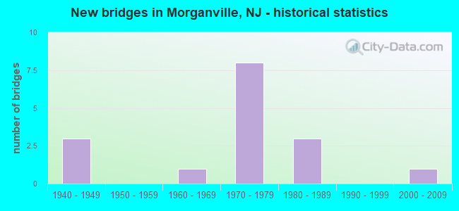
- New bridges - historical statistics
- 31940-1949
- 11960-1969
- 81970-1979
- 31980-1989
- 12000-2009

- Reconstructed bridges - Historical Statistics
- 11960-1969
- 01970-1979
- 01980-1989
- 11990-1999


- Bridge Condition - Deck
- 50.0%Good
- 40.0%Satisfactory
- 10.0%Poor

- Bridge Condition - Superstructure
- 10.0%Very good
- 20.0%Good
- 60.0%Satisfactory
- 10.0%Fair

- Bridge Condition - Substructure
- 50.0%Good
- 30.0%Satisfactory
- 20.0%Fair

- Bridge Condition - Channel
- 16.7%Good
- 66.7%Satisfactory
- 16.7%Fair
Find on map >> Show street view
Structure Number: 13000H2, Location: APPROX 1000 FT W OF NJ 34 (Lat: 40.345289, Lng: -74.197539), Route carried "on" structure: County highway 520, Year Built: 1984, Status: Open, Structure Length: 1.86m (6.10ft), Average Daily Traffic: 13,188 (year 2021), Truck Traffic: 4%, Average Future Daily Traffic: 16,092 (year 2041), Design Load: HS 20+Mod, Features Intersected: WILLOW BROOK
Minimum Vertical Clearance: 30+ m (98+ ft), Kilometerpoint: 15.112, Lanes on structure: 2, Owner: County Highway Agency, Approaching Roadway Width: 14.0m (45.9ft), Skew: 3 degrees, Material/Design: Prestressed concrete, Design/Construction: Box Beam or Girders - Multiple, Number Of Spans In Main Unit: 1, Length of Maximum Span: 17.1m (56.1ft), Curb or Sidewalk Widths: Left: 2.4m (7.9ft), Right: 2.4m (7.9ft), Curb-To-Curb Width: 14.0m (45.9ft), Out-to-Out Width: 19.7m (64.6ft)
Condition: Deck: Satisfactory, Superstructure: Satisfactory, Substructure: Satisfactory, Channel: Satisfactory, Operating Rating: 49.0 metric tons, Method Used To Determine Operating Rating: Load Factor (LF), Inventory Rating: 29.0 metric tons, Method Used To Determine Inventory Rating: Load Factor (LF), Structural Evaluation: Equal to present minimum criteria, Deck Geometry: Superior to present desirable criteria, Waterway Adequacy: Equal to present minimum criteria, Approach Roadway Alignment: Equal to present desirable criteria, Designated Inspection Frequency: Every 24 months, Inspection Date: May 2021, Deck Structure Type: Concrete Cast-file-Place, Wearing Surface/Protective System: Wearing Surface: Monolithic Concrete, Deck Protection: Epoxy Coated Reinforcing
Find on map >> Show street view
Structure Number: 1300ML6, Location: 0.08 mi. N of Wyncrest Rd (Lat: 40.316461, Lng: -74.287500), Route carried "on" structure: City street , Year Built: 1946, Year Reconstructed: 1974, Status: Open, Structure Length: 1.01m (3.31ft), Average Daily Traffic: 2,163 (year 2021), Truck Traffic: 1%, Average Future Daily Traffic: 2,640 (year 2041), Features Intersected: MILFORD BROOK, Facility Carried by Structure: ROBERTSVILLE ROAD
Minimum Vertical Clearance: 30+ m (98+ ft), Kilometerpoint: 0.000, Lanes on structure: 2, Owner: County Highway Agency, Approaching Roadway Width: 12.2m (40.0ft), Material/Design: Concrete continuous, Design/Construction: Slab, Number Of Spans In Main Unit: 2, Length of Maximum Span: 4.6m (15.1ft), Curb or Sidewalk Widths: Left: 1.5m (4.9ft), Right: 1.5m (4.9ft), Curb-To-Curb Width: 12.2m (40.0ft), Out-to-Out Width: 15.2m (49.9ft)
Condition: Deck: Satisfactory, Superstructure: Satisfactory, Substructure: Satisfactory, Channel: Satisfactory, Operating Rating: 49.0 metric tons, Method Used To Determine Operating Rating: Load Factor (LF), Inventory Rating: 29.0 metric tons, Method Used To Determine Inventory Rating: Load Factor (LF), Structural Evaluation: Equal to present minimum criteria, Deck Geometry: Equal to present minimum criteria, Waterway Adequacy: Better than present minimum criteria, Approach Roadway Alignment: Equal to present desirable criteria, Designated Inspection Frequency: Every 24 months, Inspection Date: May 2021, Deck Structure Type: Concrete Cast-file-Place, Wearing Surface/Protective System: Wearing Surface: Monolithic Concrete
Find on map >> Show street view
Structure Number: 1300ML8, Location: 0.11 MILES SOUTH OF US 9 (Lat: 40.334069, Lng: -74.305589), Route carried "on" structure: Bypass Other road , Year Built: 1981, Status: Open, Structure Length: 0.82m (2.69ft), Average Daily Traffic: 117 (year 2021), Truck Traffic: 1%, Average Future Daily Traffic: 143 (year 2041), Features Intersected: PINE BROOK, Facility Carried by Structure: CLAYTON ROAD
Minimum Vertical Clearance: 30+ m (98+ ft), Kilometerpoint: 0.000, Lanes on structure: 1, Owner: County Highway Agency, Approaching Roadway Width: 7.3m (24.0ft), Material/Design: Concrete, Design/Construction: Culvert, Number Of Spans In Main Unit: 2, Length of Maximum Span: 3.7m (12.1ft), Curb or Sidewalk Widths: Left: 2.3m (7.5ft), Right: 2.0m (6.6ft), Curb-To-Curb Width: 7.3m (24.0ft), Out-to-Out Width: 12.3m (40.4ft)
Condition: Channel: Satisfactory, Culverts: Satisfactory, Operating Rating: 84.4 metric tons, Method Used To Determine Operating Rating: Load Factor (LF), Inventory Rating: 50.8 metric tons, Method Used To Determine Inventory Rating: Load Factor (LF), Structural Evaluation: Equal to present minimum criteria, Deck Geometry: Somewhat better than minimum adequacy, Waterway Adequacy: Better than present minimum criteria, Approach Roadway Alignment: Equal to present minimum criteria, Designated Inspection Frequency: Every 24 months, Inspection Date: May 2021, Deck Structure Type: Concrete Cast-file-Place, Wearing Surface/Protective System: Wearing Surface: Bituminous
Find on map >> Show street view
Structure Number: 1303161, Location: 0.97 MI. S. OF C.R. 520 (Lat: 40.339089, Lng: -74.307561), Route carried "on" structure: City street , Year Built: 1940, Year Reconstructed: 1997, Status: Open, Structure Length: 2.87m (9.42ft), Average Daily Traffic: 18,635 (year 2021), Truck Traffic: 4%, Average Future Daily Traffic: 22,360 (year 2041), Features Intersected: US 9, Facility Carried by Structure: UNION HILL ROAD
Minimum Vertical Clearance: 30+ m (98+ ft), Kilometerpoint: 2.478, Lanes on structure: 3, Lanes under structure: 6, Owner: State Highway Agency, Approaching Roadway Width: 11.0m (36.1ft), Material/Design: Steel, Design/Construction: Stringer/Multi-beam, Number Of Spans In Main Unit: 1, Number Of Approach Spans: 1, Length of Maximum Span: 14.0m (45.9ft), Curb or Sidewalk Widths: Left: 0.0m, Right: 1.9m (6.2ft), Curb-To-Curb Width: 11.0m (36.1ft), Out-to-Out Width: 13.7m (44.9ft)
Condition: Deck: Poor, Superstructure: Fair, Substructure: Fair, Operating Rating: 54.4 metric tons, Method Used To Determine Operating Rating: Load Factor (LF), Inventory Rating: 31.8 metric tons, Method Used To Determine Inventory Rating: Load Factor (LF), Structural Evaluation: Somewhat better than minimum adequacy, Deck Geometry: High priority of replacement, Underclear: High priority of replacement, Approach Roadway Alignment: Equal to present desirable criteria, Length Of Structure Improvement: 2.87m (9.42ft), Designated Inspection Frequency: Every 24 months, Inspection Date: September 2021, Bridge Improvement Cost: $2,726,000, Roadway Improvement Cost: $272,000, Total Project Cost: $4,235,000 ( Estimate for 2021), Deck Structure Type: Concrete Cast-file-Place, Wearing Surface/Protective System: Wearing Surface: Bituminous
Find on map >> Show street view
Structure Number: 130ML13, Location: 1.5 ML N OF NJ 18 (Lat: 40.365769, Lng: -74.267111), Route carried "on" structure: County highway 3, Year Built: 1962, Status: Open, Structure Length: 1.28m (4.20ft), Average Daily Traffic: 11,299 (year 2021), Truck Traffic: 3%, Average Future Daily Traffic: 13,787 (year 2041), Features Intersected: DEEP RUN BROOK
Minimum Vertical Clearance: 30+ m (98+ ft), Kilometerpoint: 12.183, Lanes on structure: 2, Owner: County Highway Agency, Approaching Roadway Width: 9.1m (29.9ft), Skew: 3 degrees, Material/Design: Concrete continuous, Design/Construction: Slab, Number Of Spans In Main Unit: 2, Length of Maximum Span: 6.1m (20.0ft), Curb or Sidewalk Widths: Left: 0.2m (0.7ft), Right: 0.2m (0.7ft), Curb-To-Curb Width: 8.8m (28.9ft), Out-to-Out Width: 9.1m (29.9ft)
Condition: Deck: Satisfactory, Superstructure: Satisfactory, Substructure: Fair, Channel: Fair, Operating Rating: 27.2 metric tons, Method Used To Determine Operating Rating: Load Factor (LF), Inventory Rating: 16.3 metric tons, Method Used To Determine Inventory Rating: Load Factor (LF), Structural Evaluation: Meets minimum limits, Deck Geometry: High priority of replacement, Waterway Adequacy: Equal to present minimum criteria, Approach Roadway Alignment: Equal to present desirable criteria, Length Of Structure Improvement: 2.04m (6.69ft), Designated Inspection Frequency: Every 24 months, Inspection Date: May 2021, Bridge Improvement Cost: $1,293,000, Roadway Improvement Cost: $248,000, Total Project Cost: $2,040,000 ( Estimate for 2021), Deck Structure Type: Concrete Precast Panels, Wearing Surface/Protective System: Wearing Surface: Bituminous
Find on map >> Show street view
Structure Number: 130ML14, Location: 1.5 MILES NORTH OF NJ 18 (Lat: 40.359419, Lng: -74.274081), Route carried "on" structure: County highway 3, Year Built: 1980, Status: Open, Structure Length: 0.98m (3.22ft), Average Daily Traffic: 11,299 (year 2021), Truck Traffic: 4%, Average Future Daily Traffic: 13,787 (year 2041), Design Load: HS 20, Features Intersected: DEEP RUN BROOK
Minimum Vertical Clearance: 30+ m (98+ ft), Kilometerpoint: 11.265, Lanes on structure: 2, Owner: County Highway Agency, Approaching Roadway Width: 11.0m (36.1ft), Material/Design: Prestressed concrete, Design/Construction: Slab, Number Of Spans In Main Unit: 1, Length of Maximum Span: 9.1m (29.9ft), Curb or Sidewalk Widths: Left: 1.5m (4.9ft), Right: 1.5m (4.9ft), Curb-To-Curb Width: 11.0m (36.1ft), Out-to-Out Width: 14.0m (45.9ft)
Condition: Deck: Good, Superstructure: Satisfactory, Substructure: Satisfactory, Channel: Satisfactory, Operating Rating: 77.1 metric tons, Method Used To Determine Operating Rating: Load Factor (LF), Inventory Rating: 44.5 metric tons, Method Used To Determine Inventory Rating: Load Factor (LF), Structural Evaluation: Equal to present minimum criteria, Deck Geometry: Meets minimum limits, Waterway Adequacy: Equal to present minimum criteria, Approach Roadway Alignment: Equal to present desirable criteria, Designated Inspection Frequency: Every 24 months, Inspection Date: May 2021, Deck Structure Type: Concrete Precast Panels, Wearing Surface/Protective System: Wearing Surface: Bituminous
Find on map >> Show street view
Structure Number: 130ML3, Location: 0.17 MI E. of GRNWD RD. (Lat: 40.394400, Lng: -74.255331), Route carried "on" structure: County highway , Year Built: 2008, Status: Open, Structure Length: 1.07m (3.51ft), Average Daily Traffic: 708 (year 2021), Truck Traffic: 3%, Average Future Daily Traffic: 864 (year 2041), Design Load: HS 25 or greater, Features Intersected: MATAWAN BROOK, Facility Carried by Structure: TICETOWN ROAD
Minimum Vertical Clearance: 30+ m (98+ ft), Kilometerpoint: 1.239, Lanes on structure: 2, Owner: County Highway Agency, Approaching Roadway Width: 9.1m (29.9ft), Skew: 3 degrees, Material/Design: Prestressed concrete, Design/Construction: Slab, Number Of Spans In Main Unit: 1, Length of Maximum Span: 8.5m (27.9ft), Curb or Sidewalk Widths: Left: 1.8m (5.9ft), Right: 0.5m (1.6ft), Curb-To-Curb Width: 9.1m (29.9ft), Out-to-Out Width: 12.2m (40.0ft)
Condition: Deck: Good, Superstructure: Very good, Substructure: Good, Channel: Good, Inventory Rating: 63.5 metric tons, Method Used To Determine Inventory Rating: Load Factor (LF), Structural Evaluation: Better than present minimum criteria, Deck Geometry: Equal to present minimum criteria, Waterway Adequacy: Better than present minimum criteria, Approach Roadway Alignment: Equal to present desirable criteria, Designated Inspection Frequency: Every 24 months, Inspection Date: May 2021, Deck Structure Type: Concrete Cast-file-Place, Wearing Surface/Protective System: Wearing Surface: Monolithic Concrete, Deck Protection: Galvanized Reinforcing
Find on map >> Show street view
Structure Number: 132515, Location: 1.4 MI W OF 18-79 XING (Lat: 40.323439, Lng: -74.269000), Route carried "on" structure: Other road , Year Built: 1972, Status: Open, Structure Length: 5.91m (19.39ft), Average Daily Traffic: 2,114 (year 2021), Truck Traffic: 1%, Average Future Daily Traffic: 2,537 (year 2041), Design Load: HS 20, Features Intersected: NJ 18 FREEWAY, Facility Carried by Structure: WYNCREST RD
Minimum Vertical Clearance: 30+ m (98+ ft), Kilometerpoint: 5.520, Lanes on structure: 2, Lanes under structure: 4, Owner: State Highway Agency, Approaching Roadway Width: 12.2m (40.0ft), Material/Design: Steel, Design/Construction: Stringer/Multi-beam, Number Of Spans In Main Unit: 2, Length of Maximum Span: 29.0m (95.1ft), Curb or Sidewalk Widths: Left: 0.5m (1.6ft), Right: 1.8m (5.9ft), Curb-To-Curb Width: 9.1m (29.9ft), Out-to-Out Width: 12.7m (41.7ft)
Condition: Deck: Good, Superstructure: Satisfactory, Substructure: Good, Operating Rating: 74.4 metric tons, Method Used To Determine Operating Rating: Load Factor (LF), Inventory Rating: 44.5 metric tons, Method Used To Determine Inventory Rating: Load Factor (LF), Structural Evaluation: Equal to present minimum criteria, Deck Geometry: Meets minimum limits, Underclear: High priority of corrective action, Approach Roadway Alignment: Better than present minimum criteria, Length Of Structure Improvement: 5.91m (19.39ft), Designated Inspection Frequency: Every 24 months, Inspection Date: Febuary 2021, Bridge Improvement Cost: $938,000, Roadway Improvement Cost: $165,000, Total Project Cost: $1,436,000 ( Estimate for 2021), Deck Structure Type: Concrete Cast-file-Place, Wearing Surface/Protective System: Wearing Surface: Monolithic Concrete
Find on map >> Show street view
Structure Number: 1325151, Location: 2.3 MI. N OF N.J. RT. 79. (Lat: 40.333719, Lng: -74.276461), Route carried "on" structure: Other road , Year Built: 1972, Status: Open, Structure Length: 5.61m (18.41ft), Average Daily Traffic: 7,177 (year 2021), Truck Traffic: 4%, Average Future Daily Traffic: 8,758 (year 2041), Design Load: HS 20, Features Intersected: NJ 18 FREEWAY, Facility Carried by Structure: GORDONS CORNER RD.
Minimum Vertical Clearance: 30+ m (98+ ft), Kilometerpoint: 0.000, Lanes on structure: 2, Lanes under structure: 4, Base Highway Network: Yes, Owner: State Highway Agency, Approaching Roadway Width: 9.1m (29.9ft), Material/Design: Steel, Design/Construction: Box Beam or Girders - Multiple, Number Of Spans In Main Unit: 2, Length of Maximum Span: 27.4m (89.9ft), Curb or Sidewalk Widths: Left: 1.8m (5.9ft), Right: 0.5m (1.6ft), Curb-To-Curb Width: 9.1m (29.9ft), Out-to-Out Width: 12.7m (41.7ft)
Condition: Deck: Good, Superstructure: Good, Substructure: Good, Inventory Rating: 50.8 metric tons, Method Used To Determine Inventory Rating: Load Factor (LF), Structural Evaluation: Better than present minimum criteria, Deck Geometry: High priority of corrective action, Underclear: High priority of corrective action, Approach Roadway Alignment: Better than present minimum criteria, Length Of Structure Improvement: 5.61m (18.41ft), Designated Inspection Frequency: Every 24 months, Critical Feature Inspection Frequency: Every 24 months, Inspection Date: Febuary 2021, Critical Feature Inspection Date: January 2020, Bridge Improvement Cost: $188,000, Roadway Improvement Cost: $164,000, Total Project Cost: $2,595,000 ( Estimate for 2021), Deck Structure Type: Concrete Cast-file-Place, Wearing Surface/Protective System: Wearing Surface: Monolithic Concrete
Find on map >> Show street view
Structure Number: 1325153, Location: 2MI SOUTH OF US-9 INTRCHG (Lat: 40.347231, Lng: -74.283550), Route carried "on" structure: County highway 520, Year Built: 1972, Status: Open, Structure Length: 7.28m (23.88ft), Average Daily Traffic: 19,900 (year 2021), Truck Traffic: 4%, Average Future Daily Traffic: 23,800 (year 2041), Design Load: HS 20, Features Intersected: NJ 18 FWH
Minimum Vertical Clearance: 30+ m (98+ ft), Kilometerpoint: 6.727, Lanes on structure: 3, Lanes under structure: 5, Owner: State Highway Agency, Approaching Roadway Width: 14.3m (46.9ft), Skew: 3 degrees, Material/Design: Steel, Design/Construction: Stringer/Multi-beam, Number Of Spans In Main Unit: 2, Number Of Approach Spans: 2, Length of Maximum Span: 38.4m (126.0ft), Curb or Sidewalk Widths: Left: 1.8m (5.9ft), Right: 0.5m (1.6ft), Curb-To-Curb Width: 14.3m (46.9ft), Out-to-Out Width: 17.8m (58.4ft)
Condition: Deck: Good, Superstructure: Good, Substructure: Good, Operating Rating: 78.9 metric tons, Method Used To Determine Operating Rating: Load Factor (LF), Inventory Rating: 47.2 metric tons, Method Used To Determine Inventory Rating: Load Factor (LF), Structural Evaluation: Better than present minimum criteria, Deck Geometry: Somewhat better than minimum adequacy, Underclear: High priority of corrective action, Approach Roadway Alignment: Better than present minimum criteria, Length Of Structure Improvement: 7.30m (23.95ft), Designated Inspection Frequency: Every 24 months, Inspection Date: January 2021, Bridge Improvement Cost: $1,171,000, Roadway Improvement Cost: $117,000, Total Project Cost: $1,700,000 ( Estimate for 2021), Deck Structure Type: Concrete Cast-file-Place, Wearing Surface/Protective System: Wearing Surface: Monolithic Concrete
Find on map >> Show street view
Structure Number: 1325154, Location: 1.5 MI S OF US 9 JCT (Lat: 40.349339, Lng: -74.285050), Route carried "on" structure: County highway 3, Year Built: 1972, Status: Open, Structure Length: 6.83m (22.41ft), Average Daily Traffic: 11,298 (year 2021), Truck Traffic: 3%, Average Future Daily Traffic: 13,785 (year 2041), Design Load: HS 20, Features Intersected: ROUTE NJ 18
Minimum Vertical Clearance: 30+ m (98+ ft), Kilometerpoint: 9.833, Lanes on structure: 4, Lanes under structure: 6, Owner: State Highway Agency, Approaching Roadway Width: 15.2m (49.9ft), Skew: 2 degrees, Material/Design: Steel, Design/Construction: Stringer/Multi-beam, Number Of Spans In Main Unit: 2, Length of Maximum Span: 35.1m (115.2ft), Curb or Sidewalk Widths: Left: 0.5m (1.6ft), Right: 1.8m (5.9ft), Curb-To-Curb Width: 15.2m (49.9ft), Out-to-Out Width: 18.8m (61.7ft)
Condition: Deck: Satisfactory, Superstructure: Satisfactory, Substructure: Good, Inventory Rating: 53.5 metric tons, Method Used To Determine Inventory Rating: Load Factor (LF), Structural Evaluation: Equal to present minimum criteria, Deck Geometry: High priority of corrective action, Underclear: High priority of corrective action, Approach Roadway Alignment: Equal to present desirable criteria, Length Of Structure Improvement: 6.83m (22.41ft), Designated Inspection Frequency: Every 24 months, Inspection Date: March 2021, Bridge Improvement Cost: $702,000, Roadway Improvement Cost: $1,200,000, Total Project Cost: $1,900,000 ( Estimate for 2021), Deck Structure Type: Concrete Cast-file-Place, Wearing Surface/Protective System: Wearing Surface: Monolithic Concrete
Find on map >> Show street view
Structure Number: 1303161, Location: 0.97 MI. S. OF C.R. 520 (Lat: 40.339089, Lng: -74.307561), Route carried "under" structure: US 9, Year Built: 1940, Structure Length: 0. m, Average Daily Traffic: 73,325 (year 2021), Truck Traffic: 4%, Features Intersected: US 9, Facility Carried by Structure: UNION HILL ROAD
Minimum Vertical Clearance: 4.55m (14.93ft), Kilometerpoint: 193.121, Lanes on structure: 3, Lanes under structure: 6, Material/Design: Steel, Design/Construction: Stringer/Multi-beam, Length of Maximum Span: 14.0m (45.9ft)
Find on map >> Show street view
Structure Number: 132515, Location: 1.4 MI W OF 18-79 XING (Lat: 40.323439, Lng: -74.269000), Route carried "under" structure: State highway 18, Year Built: 1972, Structure Length: 0. m, Average Daily Traffic: 53,096 (year 2021), Truck Traffic: 5%, Features Intersected: NJ 18 FREEWAY, Facility Carried by Structure: WYNCREST RD
Minimum Vertical Clearance: 4.80m (15.75ft), Kilometerpoint: 42.825, Lanes on structure: 2, Lanes under structure: 4, Material/Design: Steel, Design/Construction: Stringer/Multi-beam, Length of Maximum Span: 29.0m (95.1ft)
Find on map >> Show street view
Structure Number: 1325151, Location: 2.3 MI. N OF N.J. RT. 79. (Lat: 40.333719, Lng: -74.276461), Route carried "under" structure: State highway 18, Year Built: 1972, Structure Length: 0. m, Average Daily Traffic: 50,690 (year 2019), Truck Traffic: 5%, Features Intersected: NJ 18 FREEWAY, Facility Carried by Structure: GORDONS CORNER RD.
Minimum Vertical Clearance: 4.93m (16.17ft), Kilometerpoint: 44.144, Lanes on structure: 2, Lanes under structure: 4, Material/Design: Steel, Design/Construction: Box Beam or Girders - Multiple, Length of Maximum Span: 27.4m (89.9ft)
Find on map >> Show street view
Structure Number: 1325153, Location: 2MI SOUTH OF US-9 INTRCHG (Lat: 40.347231, Lng: -74.283550), Route carried "under" structure: State highway 18, Year Built: 1972, Structure Length: 0. m, Average Daily Traffic: 45,000 (year 2021), Truck Traffic: 5%, Features Intersected: NJ 18 FWH, Facility Carried by Structure: CR 520
Minimum Vertical Clearance: 4.42m (14.50ft), Kilometerpoint: 45.705, Lanes on structure: 3, Lanes under structure: 5, Material/Design: Steel, Design/Construction: Stringer/Multi-beam, Length of Maximum Span: 38.4m (126.0ft)
Find on map >> Show street view
Structure Number: 1325154, Location: 1.5 MI S OF US 9 JCT (Lat: 40.349339, Lng: -74.285050), Route carried "under" structure: State highway 18, Year Built: 1972, Structure Length: 0. m, Average Daily Traffic: 51,887 (year 2021), Truck Traffic: 5%, Features Intersected: ROUTE NJ 18, Facility Carried by Structure: TENNENT ROAD (CR3)
Minimum Vertical Clearance: 4.65m (15.26ft), Kilometerpoint: 46.059, Lanes on structure: 4, Lanes under structure: 5, Material/Design: Steel, Design/Construction: Stringer/Multi-beam, Length of Maximum Span: 35.1m (115.2ft)