Bridge Statistics for Morley, Michigan (MI)
Condition, Traffic, Stress, Structural Evaluation, Project Costs
- National Bridge Inventory (NBI) Statistics
- 28Number of bridges
- 282ft / 85.7mTotal length
- $433,000Total costs
- 221,077Total average daily traffic
- 19,560Total average daily truck traffic
- National Bridge Inventory (NBI) Registered Bridges for Morley
- No street view available for this location
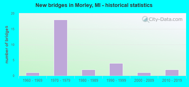
- New bridges - historical statistics
- 11960-1969
- 181970-1979
- 21980-1989
- 41990-1999
- 12000-2009
- 22010-2019


- Bridge Condition - Deck
- 11.8%Very good
- 64.7%Good
- 11.8%Satisfactory
- 11.8%Fair

- Bridge Condition - Superstructure
- 23.5%Very good
- 52.9%Good
- 11.8%Satisfactory
- 5.9%Fair
- 5.9%Poor

- Bridge Condition - Substructure
- 17.6%Very good
- 58.8%Good
- 23.5%Satisfactory

- Bridge Condition - Channel
- 25.0%Very good
- 50.0%Good
- 8.3%Satisfactory
- 16.7%Fair

- Bridge Condition - Culverts
- 50.0%Very good
- 50.0%Satisfactory
Find on map >> Show street view
Structure Number: 18, Location: VILLAGE OF BLACK RIVER (Lat: 44.815017, Lng: -83.302578), Route carried "on" structure: County highway 184, Year Built: 1984, Status: Posted for load, Structure Length: 2.43m (7.97ft), Average Daily Traffic: 280 (year 2003), Truck Traffic: 2%, Average Future Daily Traffic: 375 (year 2023), Design Load: HS 20, Features Intersected: BLACK RIVER, Facility Carried by Structure: LAKESHORE DRIVE
Minimum Vertical Clearance: 30.48m (100.00ft), Kilometerpoint: 6.993, Lanes on structure: 2, Owner: County Highway Agency, Approaching Roadway Width: 11.0m (36.1ft), Skew: 2 degrees, Material/Design: Prestressed concrete, Design/Construction: Box Beam or Girders - Multiple, Number Of Spans In Main Unit: 1, Length of Maximum Span: 22.8m (74.8ft), Curb-To-Curb Width: 11.0m (36.1ft), Out-to-Out Width: 11.4m (37.4ft)
Condition: Deck: Fair, Superstructure: Poor, Substructure: Satisfactory, Channel: Satisfactory, Operating Rating: 50.9 metric tons, Method Used To Determine Operating Rating: Load Factor (LF) rating reported by rating factor (RF) method using MS18 loading, Inventory Rating: 30.5 metric tons, Method Used To Determine Inventory Rating: Load Factor (LF) rating reported by rating factor (RF) method using MS18 loading, Structural Evaluation: Meets minimum limits, Deck Geometry: Equal to present desirable criteria, Waterway Adequacy: Better than present minimum criteria, Approach Roadway Alignment: Equal to present minimum criteria, Bridge Posting: Required (Relationship of Operating Rating to Maximum Legal Load: 10.0 - 19.9% below), Designated Inspection Frequency: Every 12 months, Inspection Date: May 2021, Deck Structure Type: Concrete Precast Panels, Wearing Surface/Protective System: Wearing Surface: Bituminous, Membrane: Preformed Fabric, Deck Protection: Epoxy Coated Reinforcing
Find on map >> Show street view
Structure Number: 2278, Location: 4.0 MI NE OF POTTERVILLE (Lat: 42.682928, Lng: -84.678322), Route carried "on" structure: County highway 2003, Year Built: 1989, Status: Open, Structure Length: 10.12m (33.20ft), Average Daily Traffic: 1,500 (year 1982), Truck Traffic: 3%, Average Future Daily Traffic: 1,500 (year 1977), Design Load: HS 20, Features Intersected: I-69, Facility Carried by Structure: DAVIS HWY
Minimum Vertical Clearance: 30.48m (100.00ft), Kilometerpoint: 5.015, Lanes on structure: 2, Lanes under structure: 4, Owner: State Highway Agency, Approaching Roadway Width: 11.8m (38.7ft), Skew: 3 degrees, Material/Design: Steel continuous, Design/Construction: Stringer/Multi-beam, Number Of Spans In Main Unit: 2, Length of Maximum Span: 53.0m (173.9ft), Curb-To-Curb Width: 11.5m (37.7ft), Out-to-Out Width: 12.5m (41.0ft)
Condition: Deck: Satisfactory, Superstructure: Satisfactory, Substructure: Good, Operating Rating: 83.3 metric tons, Method Used To Determine Operating Rating: Load Factor (LF) rating reported by rating factor (RF) method using MS18 loading, Inventory Rating: 49.9 metric tons, Method Used To Determine Inventory Rating: Load Factor (LF) rating reported by rating factor (RF) method using MS18 loading, Structural Evaluation: Equal to present minimum criteria, Deck Geometry: Equal to present minimum criteria, Underclear: Equal to present minimum criteria, Approach Roadway Alignment: Equal to present desirable criteria, Designated Inspection Frequency: Every 24 months, Inspection Date: June 2021, Deck Structure Type: Concrete Cast-file-Place, Wearing Surface/Protective System: Wearing Surface: Epoxy Overlay, Deck Protection: Epoxy Coated Reinforcing
Find on map >> Show street view
Structure Number: 5905, Location: 0.9 MI NW OF M-123 (Lat: 46.311186, Lng: -85.525658), Route carried "on" structure: State highway 28, Year Built: 1993, Status: Open, Structure Length: 0.92m (3.02ft), Average Daily Traffic: 3,756 (year 2007), Truck Traffic: 10%, Average Future Daily Traffic: 4,543 (year 2018), Design Load: HS 25 or greater, Features Intersected: E BR TEASPOON CREEK
Minimum Vertical Clearance: 30.48m (100.00ft), Kilometerpoint: 17.359, Lanes on structure: 2, Base Highway Network: Yes (Inventory Route: 126, Subroute: 6), Owner: State Highway Agency, Approaching Roadway Width: 12.2m (40.0ft), Skew: 3 degrees, Material/Design: Concrete, Design/Construction: Slab, Number Of Spans In Main Unit: 1, Length of Maximum Span: 8.5m (27.9ft), Curb-To-Curb Width: 12.2m (40.0ft), Out-to-Out Width: 30.3m (99.4ft)
Condition: Deck: Good, Superstructure: Good, Substructure: Satisfactory, Channel: Good, Operating Rating: 87.2 metric tons, Method Used To Determine Operating Rating: Load Factor (LF) rating reported by rating factor (RF) method using MS18 loading, Inventory Rating: 52.2 metric tons, Method Used To Determine Inventory Rating: Load Factor (LF) rating reported by rating factor (RF) method using MS18 loading, Structural Evaluation: Equal to present minimum criteria, Deck Geometry: Equal to present minimum criteria, Waterway Adequacy: Better than present minimum criteria, Approach Roadway Alignment: Better than present minimum criteria, Designated Inspection Frequency: Every 24 months, Inspection Date: June 2020, Deck Structure Type: Concrete Cast-file-Place, Wearing Surface/Protective System: Wearing Surface: Monolithic Concrete, Deck Protection: Epoxy Coated Reinforcing
Find on map >> Show street view
Structure Number: 5906, Location: 5.5 MI E OF M-123 (Lat: 46.303561, Lng: -85.393458), Route carried "on" structure: State highway 28, Year Built: 2001, Status: Open, Structure Length: 2.07m (6.79ft), Average Daily Traffic: 2,127 (year 2007), Truck Traffic: 18%, Average Future Daily Traffic: 3,129 (year 2018), Design Load: HS 25 or greater, Features Intersected: W BR SAGE RIVER
Minimum Vertical Clearance: 30.48m (100.00ft), Kilometerpoint: 27.880, Lanes on structure: 2, Base Highway Network: Yes (Inventory Route: 126, Subroute: 6), Owner: State Highway Agency, Approaching Roadway Width: 11.9m (39.0ft), Material/Design: Prestressed concrete, Design/Construction: Box Beam or Girders - Single/Spread, Number Of Spans In Main Unit: 1, Length of Maximum Span: 20.7m (67.9ft), Curb-To-Curb Width: 13.1m (43.0ft), Out-to-Out Width: 14.2m (46.6ft)
Condition: Deck: Very good, Superstructure: Good, Substructure: Very good, Channel: Good, Operating Rating: 74.8 metric tons, Method Used To Determine Operating Rating: Load Factor (LF) rating reported by rating factor (RF) method using MS18 loading, Inventory Rating: 23.7 metric tons, Method Used To Determine Inventory Rating: Load Factor (LF) rating reported by rating factor (RF) method using MS18 loading, Structural Evaluation: Equal to present minimum criteria, Deck Geometry: Equal to present minimum criteria, Waterway Adequacy: Better than present minimum criteria, Approach Roadway Alignment: Equal to present desirable criteria, Designated Inspection Frequency: Every 24 months, Inspection Date: June 2020, Deck Structure Type: Concrete Cast-file-Place, Wearing Surface/Protective System: Wearing Surface: Monolithic Concrete, Deck Protection: Epoxy Coated Reinforcing
Find on map >> Show street view
Structure Number: 6058, Location: 0.5 WEST OF UTICA (Lat: 42.624458, Lng: -83.061928), Route carried "on" structure: City street , Year Built: 1994, Status: Open, Structure Length: 5.42m (17.78ft), Average Daily Traffic: 35,600 (year 1991), Truck Traffic: 6%, Design Load: HS 20, Features Intersected: M-59, Facility Carried by Structure: X OVER W/MOUND RD
Minimum Vertical Clearance: 30.48m (100.00ft), Kilometerpoint: 0.032, Lanes on structure: 2, Lanes under structure: 4, Base Highway Network: Yes (Inventory Route: 420, Subroute: 39), Owner: State Highway Agency, Approaching Roadway Width: 12.8m (42.0ft), Material/Design: Prestressed concrete, Design/Construction: Stringer/Multi-beam, Number Of Spans In Main Unit: 2, Length of Maximum Span: 28.0m (91.9ft), Curb-To-Curb Width: 10.9m (35.8ft), Out-to-Out Width: 11.9m (39.0ft)
Condition: Deck: Good, Superstructure: Good, Substructure: Good, Operating Rating: 61.9 metric tons, Method Used To Determine Operating Rating: Load Factor (LF) rating reported by rating factor (RF) method using MS18 loading, Inventory Rating: 29.8 metric tons, Method Used To Determine Inventory Rating: Load Factor (LF) rating reported by rating factor (RF) method using MS18 loading, Structural Evaluation: Better than present minimum criteria, Deck Geometry: Meets minimum limits, Underclear: Somewhat better than minimum adequacy, Approach Roadway Alignment: Equal to present desirable criteria, Designated Inspection Frequency: Every 24 months, Inspection Date: November 2021, Deck Structure Type: Concrete Cast-file-Place, Wearing Surface/Protective System: Wearing Surface: Monolithic Concrete, Deck Protection: Epoxy Coated Reinforcing
Find on map >> Show street view
Structure Number: 6691, Location: IN MORLEY (Lat: 43.486036, Lng: -85.445083), Route carried "on" structure: US 131, Year Built: 1993, Status: Open, Structure Length: 6.09m (19.98ft), Average Daily Traffic: 5,177 (year 2007), Truck Traffic: 4%, Average Future Daily Traffic: 8,766 (year 2018), Design Load: HS 25 or greater, Features Intersected: LITTLE MUSKEGON RIVER
Minimum Vertical Clearance: 30.48m (100.00ft), Kilometerpoint: 2.026, Lanes on structure: 2, Owner: State Highway Agency, Approaching Roadway Width: 12.2m (40.0ft), Material/Design: Prestressed concrete, Design/Construction: Stringer/Multi-beam, Number Of Spans In Main Unit: 2, Length of Maximum Span: 30.4m (99.7ft), Curb-To-Curb Width: 14.6m (47.9ft), Out-to-Out Width: 15.3m (50.2ft)
Condition: Deck: Good, Superstructure: Good, Substructure: Good, Channel: Very good, Operating Rating: 68.7 metric tons, Method Used To Determine Operating Rating: Load Factor (LF) rating reported by rating factor (RF) method using MS18 loading, Inventory Rating: 42.1 metric tons, Method Used To Determine Inventory Rating: Load Factor (LF) rating reported by rating factor (RF) method using MS18 loading, Structural Evaluation: Better than present minimum criteria, Deck Geometry: Superior to present desirable criteria, Waterway Adequacy: Equal to present desirable criteria, Approach Roadway Alignment: Equal to present desirable criteria, Designated Inspection Frequency: Every 24 months, Underwater Inspection Frequency: Every 60 months, Inspection Date: June 2021, Underwater Inspection Date: May 2020, Bridge Improvement Cost: $263,000, Deck Structure Type: Concrete Cast-file-Place, Wearing Surface/Protective System: Wearing Surface: Monolithic Concrete, Deck Protection: Epoxy Coated Reinforcing
Find on map >> Show street view
Structure Number: 6706, Location: WEST OF MORLEY (Lat: 43.472128, Lng: -85.478156), Route carried "on" structure: US 131, Year Built: 1979, Status: Open, Structure Length: 6.22m (20.41ft), Average Daily Traffic: 20,200 (year 2013), Truck Traffic: 9%, Average Future Daily Traffic: 23,500 (year 2033), Design Load: HS 25 or greater, Features Intersected: LITTLE MUSKEGON RIVER
Minimum Vertical Clearance: 30.48m (100.00ft), Kilometerpoint: 0.480, Lanes on structure: 2, Base Highway Network: Yes (Inventory Route: 180, Subroute: 10), Owner: State Highway Agency, Approaching Roadway Width: 13.1m (43.0ft), Material/Design: Steel, Design/Construction: Stringer/Multi-beam, Number Of Spans In Main Unit: 3, Length of Maximum Span: 31.1m (102.0ft), Curb-To-Curb Width: 12.8m (42.0ft), Out-to-Out Width: 14.0m (45.9ft)
Condition: Deck: Good, Superstructure: Good, Substructure: Very good, Channel: Good, Operating Rating: 84.2 metric tons, Method Used To Determine Operating Rating: Load Factor (LF) rating reported by rating factor (RF) method using MS18 loading, Inventory Rating: 50.5 metric tons, Method Used To Determine Inventory Rating: Load Factor (LF) rating reported by rating factor (RF) method using MS18 loading, Structural Evaluation: Better than present minimum criteria, Deck Geometry: Equal to present desirable criteria, Waterway Adequacy: Equal to present desirable criteria, Approach Roadway Alignment: Equal to present desirable criteria, Designated Inspection Frequency: Every 24 months, Inspection Date: June 2021, Deck Structure Type: Concrete Cast-file-Place, Wearing Surface/Protective System: Wearing Surface: Monolithic Concrete, Deck Protection: Epoxy Coated Reinforcing
Find on map >> Show street view
Structure Number: 6707, Location: WEST OF MORLEY (Lat: 43.472522, Lng: -85.477428), Route carried "on" structure: US 131, Year Built: 1979, Status: Open, Structure Length: 7.99m (26.21ft), Average Daily Traffic: 20,200 (year 2013), Truck Traffic: 9%, Average Future Daily Traffic: 23,500 (year 2033), Design Load: HS 25 or greater, Features Intersected: LITTLE MUSKEGON RIVER
Minimum Vertical Clearance: 30.48m (100.00ft), Kilometerpoint: 0.539, Lanes on structure: 2, Base Highway Network: Yes (Inventory Route: 180, Subroute: 5), Owner: State Highway Agency, Approaching Roadway Width: 13.1m (43.0ft), Skew: 4 degrees, Material/Design: Steel, Design/Construction: Stringer/Multi-beam, Number Of Spans In Main Unit: 3, Length of Maximum Span: 40.5m (132.9ft), Curb-To-Curb Width: 12.8m (42.0ft), Out-to-Out Width: 14.0m (45.9ft)
Condition: Deck: Good, Superstructure: Satisfactory, Substructure: Good, Channel: Good, Operating Rating: 83.9 metric tons, Method Used To Determine Operating Rating: Load Factor (LF) rating reported by rating factor (RF) method using MS18 loading, Inventory Rating: 44.7 metric tons, Method Used To Determine Inventory Rating: Load Factor (LF) rating reported by rating factor (RF) method using MS18 loading, Structural Evaluation: Equal to present minimum criteria, Deck Geometry: Equal to present desirable criteria, Waterway Adequacy: Equal to present desirable criteria, Approach Roadway Alignment: Equal to present desirable criteria, Designated Inspection Frequency: Every 24 months, Inspection Date: June 2021, Deck Structure Type: Concrete Cast-file-Place, Wearing Surface/Protective System: Wearing Surface: Monolithic Concrete
Find on map >> Show street view
Structure Number: 6708, Location: 2 MILES WEST OF MORLEY (Lat: 43.489722, Lng: -85.485136), Route carried "on" structure: County highway 5406, Year Built: 1979, Status: Open, Structure Length: 4.28m (14.04ft), Average Daily Traffic: 1,050 (year 1993), Average Future Daily Traffic: 1,207 (year 2013), Design Load: HS 20, Features Intersected: US-131 SB, Facility Carried by Structure: JEFFERSON ROAD
Minimum Vertical Clearance: 30.48m (100.00ft), Kilometerpoint: 6.301, Lanes on structure: 2, Lanes under structure: 2, Owner: State Highway Agency, Approaching Roadway Width: 12.2m (40.0ft), Skew: 1 degrees, Material/Design: Steel, Design/Construction: Stringer/Multi-beam, Number Of Spans In Main Unit: 1, Length of Maximum Span: 42.6m (139.8ft), Curb-To-Curb Width: 12.8m (42.0ft), Out-to-Out Width: 14.0m (45.9ft)
Condition: Deck: Good, Superstructure: Good, Substructure: Good, Operating Rating: 87.8 metric tons, Method Used To Determine Operating Rating: Load Factor (LF) rating reported by rating factor (RF) method using MS18 loading, Inventory Rating: 52.5 metric tons, Method Used To Determine Inventory Rating: Load Factor (LF) rating reported by rating factor (RF) method using MS18 loading, Structural Evaluation: Better than present minimum criteria, Deck Geometry: Better than present minimum criteria, Underclear: Better than present minimum criteria, Approach Roadway Alignment: Equal to present desirable criteria, Length Of Structure Improvement: 4.27m (14.01ft), Designated Inspection Frequency: Every 24 months, Inspection Date: May 2021, Bridge Improvement Cost: $145,000, Roadway Improvement Cost: $8,000, Total Project Cost: $90,000, Deck Structure Type: Concrete Cast-file-Place, Wearing Surface/Protective System: Wearing Surface: Monolithic Concrete, Deck Protection: Epoxy Coated Reinforcing
Find on map >> Show street view
Structure Number: 6709, Location: 2 MILES WEST OF MORLEY (Lat: 43.489731, Lng: -85.483806), Route carried "on" structure: County highway 5406, Year Built: 1979, Status: Open, Structure Length: 4.28m (14.04ft), Average Daily Traffic: 1,050 (year 1988), Average Future Daily Traffic: 1,207 (year 2008), Design Load: HS 20, Features Intersected: NB US-131, Facility Carried by Structure: JEFFERSON ROAD
Minimum Vertical Clearance: 30.48m (100.00ft), Kilometerpoint: 6.409, Lanes on structure: 2, Lanes under structure: 2, Owner: State Highway Agency, Approaching Roadway Width: 13.1m (43.0ft), Skew: 1 degrees, Material/Design: Steel, Design/Construction: Stringer/Multi-beam, Number Of Spans In Main Unit: 1, Length of Maximum Span: 41.7m (136.8ft), Curb-To-Curb Width: 12.8m (42.0ft), Out-to-Out Width: 14.0m (45.9ft)
Condition: Deck: Good, Superstructure: Good, Substructure: Good, Operating Rating: 82.0 metric tons, Method Used To Determine Operating Rating: Load Factor (LF) rating reported by rating factor (RF) method using MS18 loading, Inventory Rating: 49.2 metric tons, Method Used To Determine Inventory Rating: Load Factor (LF) rating reported by rating factor (RF) method using MS18 loading, Structural Evaluation: Better than present minimum criteria, Deck Geometry: Better than present minimum criteria, Underclear: Better than present minimum criteria, Approach Roadway Alignment: Equal to present desirable criteria, Length Of Structure Improvement: 4.18m (13.71ft), Designated Inspection Frequency: Every 24 months, Inspection Date: May 2021, Bridge Improvement Cost: $145,000, Roadway Improvement Cost: $8,000, Total Project Cost: $90,000, Deck Structure Type: Concrete Cast-file-Place, Wearing Surface/Protective System: Wearing Surface: Monolithic Concrete, Deck Protection: Epoxy Coated Reinforcing
Find on map >> Show street view
Structure Number: 671, Location: WEST OF MORLEY (Lat: 43.511411, Lng: -85.486744), Route carried "on" structure: US 131, Year Built: 1979, Year Reconstructed: 2014, Status: Open, Structure Length: 2.62m (8.60ft), Average Daily Traffic: 20,300 (year 2014), Truck Traffic: 9%, Average Future Daily Traffic: 23,600 (year 2034), Design Load: Greater than HL93, Features Intersected: 3 MILE ROAD
Minimum Vertical Clearance: 30.48m (100.00ft), Kilometerpoint: 4.915, Lanes on structure: 2, Lanes under structure: 2, Base Highway Network: Yes (Inventory Route: 180, Subroute: 10), Owner: State Highway Agency, Approaching Roadway Width: 16.3m (53.5ft), Material/Design: Prestressed concrete, Design/Construction: Box Beam or Girders - Single/Spread, Number Of Spans In Main Unit: 1, Length of Maximum Span: 25.5m (83.7ft), Curb-To-Curb Width: 16.3m (53.5ft), Out-to-Out Width: 17.4m (57.1ft)
Condition: Deck: Good, Superstructure: Very good, Substructure: Good, Operating Rating: 51.8 metric tons, Method Used To Determine Operating Rating: Load and Resistance Factor Rating (LRFR) rating reported by rating factor(RF) method using HL-93 loadings, Inventory Rating: 33.7 metric tons, Method Used To Determine Inventory Rating: Load and Resistance Factor Rating (LRFR) rating reported by rating factor(RF) method using HL-93 loadings, Structural Evaluation: Better than present minimum criteria, Deck Geometry: Superior to present desirable criteria, Underclear: Equal to present minimum criteria, Approach Roadway Alignment: Equal to present desirable criteria, Designated Inspection Frequency: Every 24 months, Inspection Date: June 2021, Deck Structure Type: Concrete Cast-file-Place, Wearing Surface/Protective System: Wearing Surface: Monolithic Concrete, Deck Protection: Epoxy Coated Reinforcing
Find on map >> Show street view
Structure Number: 6711, Location: WEST OF MORLEY (Lat: 43.511419, Lng: -85.485967), Route carried "on" structure: US 131, Year Built: 1979, Year Reconstructed: 2014, Status: Open, Structure Length: 2.62m (8.60ft), Average Daily Traffic: 20,300 (year 2014), Truck Traffic: 9%, Average Future Daily Traffic: 23,600 (year 2034), Design Load: Greater than HL93, Features Intersected: 3 MILE ROAD
Minimum Vertical Clearance: 30.48m (100.00ft), Kilometerpoint: 4.912, Lanes on structure: 2, Lanes under structure: 2, Base Highway Network: Yes (Inventory Route: 180, Subroute: 5), Owner: State Highway Agency, Approaching Roadway Width: 16.3m (53.5ft), Material/Design: Prestressed concrete, Design/Construction: Box Beam or Girders - Single/Spread, Number Of Spans In Main Unit: 1, Length of Maximum Span: 25.5m (83.7ft), Curb-To-Curb Width: 16.3m (53.5ft), Out-to-Out Width: 17.4m (57.1ft)
Condition: Deck: Good, Superstructure: Very good, Substructure: Satisfactory, Operating Rating: 51.8 metric tons, Method Used To Determine Operating Rating: Load and Resistance Factor Rating (LRFR) rating reported by rating factor(RF) method using HL-93 loadings, Inventory Rating: 33.7 metric tons, Method Used To Determine Inventory Rating: Load and Resistance Factor Rating (LRFR) rating reported by rating factor(RF) method using HL-93 loadings, Structural Evaluation: Equal to present minimum criteria, Deck Geometry: Superior to present desirable criteria, Underclear: Equal to present minimum criteria, Approach Roadway Alignment: Equal to present desirable criteria, Designated Inspection Frequency: Every 24 months, Inspection Date: June 2021, Deck Structure Type: Concrete Cast-file-Place, Wearing Surface/Protective System: Wearing Surface: Monolithic Concrete, Deck Protection: Epoxy Coated Reinforcing
Find on map >> Show street view
Structure Number: 6712, Location: 3 MILES NW OF MORLEY (Lat: 43.525842, Lng: -85.486039), Route carried "on" structure: County highway , Year Built: 1979, Status: Open, Structure Length: 11.37m (37.30ft), Average Daily Traffic: 110 (year 1981), Average Future Daily Traffic: 110 (year 1977), Design Load: H 20, Features Intersected: US 131, Facility Carried by Structure: 4 MILE ROAD
Minimum Vertical Clearance: 30.48m (100.00ft), Kilometerpoint: 6.203, Lanes on structure: 2, Lanes under structure: 4, Owner: State Highway Agency, Approaching Roadway Width: 10.3m (33.8ft), Material/Design: Steel, Design/Construction: Stringer/Multi-beam, Number Of Spans In Main Unit: 5, Length of Maximum Span: 29.8m (97.8ft), Curb-To-Curb Width: 11.3m (37.1ft), Out-to-Out Width: 12.1m (39.7ft)
Condition: Deck: Good, Superstructure: Good, Substructure: Good, Operating Rating: 75.2 metric tons, Method Used To Determine Operating Rating: Load Factor (LF) rating reported by rating factor (RF) method using MS18 loading, Inventory Rating: 45.0 metric tons, Method Used To Determine Inventory Rating: Load Factor (LF) rating reported by rating factor (RF) method using MS18 loading, Structural Evaluation: Better than present minimum criteria, Deck Geometry: Equal to present minimum criteria, Underclear: Superior to present desirable criteria, Approach Roadway Alignment: Equal to present desirable criteria, Length Of Structure Improvement: 11.37m (37.30ft), Designated Inspection Frequency: Every 24 months, Inspection Date: June 2021, Bridge Improvement Cost: $176,000, Roadway Improvement Cost: $9,000, Total Project Cost: $107,000, Deck Structure Type: Concrete Cast-file-Place, Wearing Surface/Protective System: Wearing Surface: Monolithic Concrete
Find on map >> Show street view
Structure Number: 6757, Location: EAST OF MORLEY (Lat: 43.490356, Lng: -85.431542), Route carried "on" structure: County highway 5406, Year Built: 1969, Status: Open, Structure Length: 1.95m (6.40ft), Average Daily Traffic: 1,300 (year 2019), Truck Traffic: 10%, Average Future Daily Traffic: 1,510 (year 2039), Design Load: HS 20, Features Intersected: LITTLE MUSKEGON RIVER, Facility Carried by Structure: JEFFERSON ROAD
Minimum Vertical Clearance: 30.48m (100.00ft), Kilometerpoint: 1.041, Lanes on structure: 2, Owner: County Highway Agency, Approaching Roadway Width: 6.7m (22.0ft), Skew: 2 degrees, Material/Design: Prestressed concrete, Design/Construction: Box Beam or Girders - Multiple, Number Of Spans In Main Unit: 1, Length of Maximum Span: 17.6m (57.7ft), Curb-To-Curb Width: 11.0m (36.1ft), Out-to-Out Width: 11.2m (36.7ft)
Condition: Deck: Fair, Superstructure: Fair, Substructure: Satisfactory, Channel: Good, Operating Rating: 61.6 metric tons, Method Used To Determine Operating Rating: Load Factor (LF) rating reported by rating factor (RF) method using MS18 loading, Inventory Rating: 36.9 metric tons, Method Used To Determine Inventory Rating: Load Factor (LF) rating reported by rating factor (RF) method using MS18 loading, Structural Evaluation: Somewhat better than minimum adequacy, Deck Geometry: Equal to present minimum criteria, Waterway Adequacy: Equal to present desirable criteria, Approach Roadway Alignment: Equal to present desirable criteria, Designated Inspection Frequency: Every 24 months, Inspection Date: August 2021, Deck Structure Type: Concrete Cast-file-Place, Wearing Surface/Protective System: Wearing Surface: Bituminous
Find on map >> Show street view
Structure Number: 6768, Location: 0.2 MI N OF WASHINGTON RD (Lat: 43.477775, Lng: -85.462603), Route carried "on" structure: County highway , Year Built: 2013, Status: Open, Structure Length: 2.56m (8.40ft), Average Daily Traffic: 204 (year 2020), Truck Traffic: 3%, Average Future Daily Traffic: 237 (year 2040), Design Load: Greater than HL93, Features Intersected: LITTLE MUSKEGON RIVER, Facility Carried by Structure: 190TH AVE
Minimum Vertical Clearance: 30.48m (100.00ft), Kilometerpoint: 0.309, Lanes on structure: 2, Owner: County Highway Agency, Approaching Roadway Width: 9.1m (29.9ft), Skew: 1 degrees, Material/Design: Prestressed concrete, Design/Construction: Box Beam or Girders - Multiple, Number Of Spans In Main Unit: 1, Length of Maximum Span: 25.2m (82.7ft), Curb-To-Curb Width: 8.6m (28.2ft), Out-to-Out Width: 9.5m (31.2ft)
Condition: Deck: Very good, Superstructure: Very good, Substructure: Very good, Channel: Very good, Operating Rating: 78.4 metric tons, Method Used To Determine Operating Rating: Load and Resistance Factor Rating (LRFR) rating reported by rating factor(RF) method using HL-93 loadings, Inventory Rating: 58.3 metric tons, Method Used To Determine Inventory Rating: Load and Resistance Factor Rating (LRFR) rating reported by rating factor(RF) method using HL-93 loadings, Structural Evaluation: Equal to present desirable criteria, Deck Geometry: Equal to present minimum criteria, Waterway Adequacy: Equal to present desirable criteria, Approach Roadway Alignment: Equal to present desirable criteria, Designated Inspection Frequency: Every 24 months, Inspection Date: August 2021, Deck Structure Type: Concrete Cast-file-Place, Wearing Surface/Protective System: Wearing Surface: Monolithic Concrete, Deck Protection: Epoxy Coated Reinforcing
Find on map >> Show street view
Structure Number: 6786, Location: VILLAGE OF MORLEY (Lat: 43.489633, Lng: -85.448864), Route carried "on" structure: City street , Year Built: 1992, Status: Open, Structure Length: 1.09m (3.58ft), Average Daily Traffic: 3,081 (year 1995), Average Future Daily Traffic: 5,550 (year 2015), Design Load: HS 20+Mod, Features Intersected: BIG CREEK, Facility Carried by Structure: JEFFERSON STREET
Minimum Vertical Clearance: 30.48m (100.00ft), Kilometerpoint: 9.236, Lanes on structure: 2, Owner: City or Municipal Highway Agency, Approaching Roadway Width: 10.1m (33.1ft), Material/Design: Concrete, Design/Construction: Culvert, Number Of Spans In Main Unit: 1, Length of Maximum Span: 10.9m (35.8ft), Curb-To-Curb Width: 11.9m (39.0ft), Out-to-Out Width: 11.9m (39.0ft)
Condition: Channel: Very good, Culverts: Very good, Operating Rating: 54.5 metric tons, Method Used To Determine Operating Rating: Field evaluation and documented engineering judgment, Inventory Rating: 32.7 metric tons, Method Used To Determine Inventory Rating: Field evaluation and documented engineering judgment, Structural Evaluation: Equal to present desirable criteria, Deck Geometry: Somewhat better than minimum adequacy, Waterway Adequacy: Equal to present desirable criteria, Approach Roadway Alignment: Equal to present desirable criteria, Designated Inspection Frequency: Every 24 months, Inspection Date: June 2020, Wearing Surface/Protective System: Wearing Surface: Bituminous
Find on map >> Show street view
Structure Number: 7416, Location: 0.2 MI S OF CUTLER RD (Lat: 43.455228, Lng: -85.481478), Route carried "on" structure: US 131, Year Built: 1979, Status: Open, Structure Length: 0.61m (2.00ft), Average Daily Traffic: 10,150 (year 2014), Truck Traffic: 9%, Average Future Daily Traffic: 11,800 (year 2034), Design Load: HS 20, Features Intersected: BRUCE CREEK
Minimum Vertical Clearance: 30.48m (100.00ft), Kilometerpoint: 19.545, Lanes on structure: 2, Base Highway Network: Yes (Inventory Route: 120, Subroute: 5), Owner: State Highway Agency, Approaching Roadway Width: 11.0m (36.1ft), Material/Design: Concrete, Design/Construction: Culvert, Number Of Spans In Main Unit: 2, Length of Maximum Span: 3.0m (9.8ft)
Condition: Channel: Fair, Culverts: Satisfactory, Operating Rating: 97.2 metric tons, Method Used To Determine Operating Rating: Load Factor (LF) rating reported by rating factor (RF) method using MS18 loading, Inventory Rating: 97.2 metric tons, Method Used To Determine Inventory Rating: Load Factor (LF) rating reported by rating factor (RF) method using MS18 loading, Structural Evaluation: Equal to present minimum criteria, Waterway Adequacy: Equal to present minimum criteria, Approach Roadway Alignment: Equal to present minimum criteria, Designated Inspection Frequency: Every 24 months, Inspection Date: January 2021, Wearing Surface/Protective System: Wearing Surface: Bituminous
Find on map >> Show street view
Structure Number: 7417, Location: 0.2 MI S OF CUTLER RD (Lat: 43.455494, Lng: -85.482800), Route carried "on" structure: US 131, Year Built: 1979, Status: Open, Structure Length: 0.61m (2.00ft), Average Daily Traffic: 10,150 (year 2014), Truck Traffic: 9%, Average Future Daily Traffic: 11,800 (year 2034), Design Load: HS 20, Features Intersected: BRUCE CREEK
Minimum Vertical Clearance: 30.48m (100.00ft), Kilometerpoint: 19.582, Lanes on structure: 2, Base Highway Network: Yes (Inventory Route: 120, Subroute: 1), Owner: State Highway Agency, Approaching Roadway Width: 11.0m (36.1ft), Material/Design: Concrete, Design/Construction: Culvert, Number Of Spans In Main Unit: 2, Length of Maximum Span: 3.0m (9.8ft)
Condition: Channel: Fair, Culverts: Satisfactory, Operating Rating: 97.2 metric tons, Method Used To Determine Operating Rating: Load Factor (LF) rating reported by rating factor (RF) method using MS18 loading, Inventory Rating: 97.2 metric tons, Method Used To Determine Inventory Rating: Load Factor (LF) rating reported by rating factor (RF) method using MS18 loading, Structural Evaluation: Equal to present minimum criteria, Waterway Adequacy: Meets minimum limits, Approach Roadway Alignment: Equal to present minimum criteria, Designated Inspection Frequency: Every 24 months, Inspection Date: January 2021, Wearing Surface/Protective System: Wearing Surface: Bituminous
Find on map >> Show street view
Structure Number: 7429, Location: 4 MI NW OF HOWARD CITY (Lat: 43.457311, Lng: -85.481422), Route carried "on" structure: County highway , Year Built: 1979, Status: Open, Structure Length: 5.54m (18.18ft), Average Daily Traffic: 330 (year 1988), Truck Traffic: 3%, Average Future Daily Traffic: 380 (year 2008), Design Load: HS 20, Features Intersected: US-131 SB, Facility Carried by Structure: CUTLER ROAD
Minimum Vertical Clearance: 30.48m (100.00ft), Kilometerpoint: 0.472, Lanes on structure: 2, Lanes under structure: 2, Owner: State Highway Agency, Approaching Roadway Width: 10.3m (33.8ft), Skew: 2 degrees, Material/Design: Steel, Design/Construction: Stringer/Multi-beam, Number Of Spans In Main Unit: 3, Length of Maximum Span: 30.4m (99.7ft), Curb-To-Curb Width: 11.4m (37.4ft), Out-to-Out Width: 12.1m (39.7ft)
Condition: Deck: Satisfactory, Superstructure: Very good, Substructure: Good, Operating Rating: 73.9 metric tons, Method Used To Determine Operating Rating: Load Factor (LF) rating reported by rating factor (RF) method using MS18 loading, Inventory Rating: 44.1 metric tons, Method Used To Determine Inventory Rating: Load Factor (LF) rating reported by rating factor (RF) method using MS18 loading, Structural Evaluation: Better than present minimum criteria, Deck Geometry: Superior to present desirable criteria, Underclear: Superior to present desirable criteria, Approach Roadway Alignment: Equal to present desirable criteria, Length Of Structure Improvement: 5.55m (18.21ft), Designated Inspection Frequency: Every 24 months, Inspection Date: July 2021, Bridge Improvement Cost: $91,000, Roadway Improvement Cost: $5,000, Total Project Cost: $56,000, Deck Structure Type: Concrete Cast-file-Place, Wearing Surface/Protective System: Wearing Surface: Monolithic Concrete, Deck Protection: Epoxy Coated Reinforcing
Find on map >> Show street view
Structure Number: 743, Location: 4.0 MI NW OF HOWARD CITY (Lat: 43.457289, Lng: -85.479808), Route carried "on" structure: County highway , Year Built: 1978, Status: Open, Structure Length: 6.18m (20.28ft), Average Daily Traffic: 330 (year 1988), Average Future Daily Traffic: 380 (year 2008), Design Load: HS 20, Features Intersected: US-131 NB & RAMP, Facility Carried by Structure: CUTLER ROAD
Minimum Vertical Clearance: 30.48m (100.00ft), Kilometerpoint: 0.602, Lanes on structure: 2, Lanes under structure: 3, Owner: State Highway Agency, Approaching Roadway Width: 11.5m (37.7ft), Skew: 2 degrees, Material/Design: Steel, Design/Construction: Stringer/Multi-beam, Number Of Spans In Main Unit: 3, Length of Maximum Span: 40.5m (132.9ft), Curb-To-Curb Width: 11.3m (37.1ft), Out-to-Out Width: 12.1m (39.7ft)
Condition: Deck: Good, Superstructure: Good, Substructure: Good, Operating Rating: 86.8 metric tons, Method Used To Determine Operating Rating: Load Factor (LF) rating reported by rating factor (RF) method using MS18 loading, Inventory Rating: 51.8 metric tons, Method Used To Determine Inventory Rating: Load Factor (LF) rating reported by rating factor (RF) method using MS18 loading, Structural Evaluation: Better than present minimum criteria, Deck Geometry: Superior to present desirable criteria, Underclear: Better than present minimum criteria, Approach Roadway Alignment: Equal to present desirable criteria, Length Of Structure Improvement: 6.19m (20.31ft), Designated Inspection Frequency: Every 24 months, Inspection Date: July 2021, Bridge Improvement Cost: $145,000, Roadway Improvement Cost: $8,000, Total Project Cost: $90,000, Deck Structure Type: Concrete Cast-file-Place, Wearing Surface/Protective System: Wearing Surface: Monolithic Concrete
Find on map >> Show street view
Structure Number: 13827, Location: VILLAGE OF MORLEY (Lat: 43.497194, Lng: -85.449750), Route carried "on" structure: City street , Year Built: 2010, Status: Open, Structure Length: 0.69m (2.26ft), Average Daily Traffic: 30 (year 2012), Average Future Daily Traffic: 35 (year 2032), Design Load: H 20, Features Intersected: BIG CREEK, Facility Carried by Structure: TWO MILE RD, 9TH
Minimum Vertical Clearance: 30.48m (100.00ft), Kilometerpoint: 1.040, Lanes on structure: 2, Owner: City or Municipal Highway Agency, Approaching Roadway Width: 6.1m (20.0ft), Skew: 1 degrees, Material/Design: Concrete, Design/Construction: Culvert, Number Of Spans In Main Unit: 1, Length of Maximum Span: 6.3m (20.7ft)
Condition: Channel: Good, Culverts: Very good, Operating Rating: 51.8 metric tons, Method Used To Determine Operating Rating: Load Factor (LF) rating reported by rating factor (RF) method using MS18 loading, Inventory Rating: 24.6 metric tons, Method Used To Determine Inventory Rating: Load Factor (LF) rating reported by rating factor (RF) method using MS18 loading, Structural Evaluation: Equal to present minimum criteria, Waterway Adequacy: Better than present minimum criteria, Approach Roadway Alignment: Equal to present desirable criteria, Designated Inspection Frequency: Every 24 months, Inspection Date: June 2020, Wearing Surface/Protective System: Wearing Surface: Gravel
Find on map >> Show street view
Structure Number: 6708, Location: 2 MILES WEST OF MORLEY (Lat: 43.489722, Lng: -85.485136), Route carried "under" structure: US 131, Year Built: 1979, Structure Length: 0. m, Average Daily Traffic: 10,938 (year 2007), Truck Traffic: 12%, Features Intersected: US-131 SB, Facility Carried by Structure: JEFFERSON ROAD
Minimum Vertical Clearance: 5.03m (16.50ft), Kilometerpoint: 2.495, Lanes on structure: 2, Lanes under structure: 2, Material/Design: Steel, Design/Construction: Stringer/Multi-beam, Length of Maximum Span: 42.6m (139.8ft)
Find on map >> Show street view
Structure Number: 6709, Location: 2 MILES WEST OF MORLEY (Lat: 43.489731, Lng: -85.483806), Route carried "under" structure: US 131, Year Built: 1979, Structure Length: 0. m, Average Daily Traffic: 10,938 (year 2007), Truck Traffic: 12%, Features Intersected: NB US-131, Facility Carried by Structure: JEFFERSON ROAD
Minimum Vertical Clearance: 5.11m (16.77ft), Kilometerpoint: 2.485, Lanes on structure: 2, Lanes under structure: 2, Material/Design: Steel, Design/Construction: Stringer/Multi-beam, Length of Maximum Span: 41.7m (136.8ft)
Find on map >> Show street view
Structure Number: 671, Location: WEST OF MORLEY (Lat: 43.511411, Lng: -85.486744), Route carried "under" structure: County highway 54, Year Built: 1979, Structure Length: 0. m, Average Daily Traffic: 550 (year 1988), Features Intersected: 3 MILE ROAD, Facility Carried by Structure: US-131 SB
Minimum Vertical Clearance: 4.67m (15.32ft), Kilometerpoint: 6.138, Lanes on structure: 2, Lanes under structure: 2, Material/Design: Prestressed concrete, Design/Construction: Box Beam or Girders - Single/Spread, Length of Maximum Span: 25.5m (83.7ft)
Find on map >> Show street view
Structure Number: 6711, Location: WEST OF MORLEY (Lat: 43.511419, Lng: -85.485967), Route carried "under" structure: City street 1, Year Built: 1979, Structure Length: 0. m, Average Daily Traffic: 550 (year 1988), Features Intersected: 3 MILE ROAD
Minimum Vertical Clearance: 4.47m (14.67ft), Kilometerpoint: 6.201, Lanes on structure: 2, Lanes under structure: 2, Material/Design: Prestressed concrete, Design/Construction: Box Beam or Girders - Single/Spread, Length of Maximum Span: 25.5m (83.7ft)
Find on map >> Show street view
Structure Number: 6712, Location: 3 MILES NW OF MORLEY (Lat: 43.525842, Lng: -85.486039), Route carried "under" structure: US 131, Year Built: 1979, Structure Length: 0. m, Average Daily Traffic: 21,876 (year 2007), Truck Traffic: 12%, Features Intersected: US 131, Facility Carried by Structure: 4 MILE ROAD
Minimum Vertical Clearance: 6.10m (20.01ft), Kilometerpoint: 6.513, Lanes on structure: 2, Lanes under structure: 4, Material/Design: Steel, Design/Construction: Stringer/Multi-beam, Length of Maximum Span: 29.8m (97.8ft)
Find on map >> Show street view
Structure Number: 7429, Location: 4 MI NW OF HOWARD CITY (Lat: 43.457311, Lng: -85.481422), Route carried "under" structure: US 131, Year Built: 1979, Structure Length: 0. m, Average Daily Traffic: 9,500 (year 2007), Truck Traffic: 10%, Features Intersected: US-131 SB, Facility Carried by Structure: CUTLER ROAD
Minimum Vertical Clearance: 5.23m (17.16ft), Kilometerpoint: 19.812, Lanes on structure: 2, Lanes under structure: 2, Material/Design: Steel, Design/Construction: Stringer/Multi-beam, Length of Maximum Span: 30.4m (99.7ft)
Find on map >> Show street view
Structure Number: 743, Location: 4.0 MI NW OF HOWARD CITY (Lat: 43.457289, Lng: -85.479808), Route carried "under" structure: US 131, Year Built: 1978, Structure Length: 0. m, Average Daily Traffic: 9,500 (year 2007), Truck Traffic: 10%, Features Intersected: US-131 NB & RAMP, Facility Carried by Structure: CUTLER ROAD
Minimum Vertical Clearance: 5.08m (16.67ft), Kilometerpoint: 19.810, Lanes on structure: 2, Lanes under structure: 3, Material/Design: Steel, Design/Construction: Stringer/Multi-beam, Length of Maximum Span: 40.5m (132.9ft)