Bridge Statistics for Morrisville, Pennsylvania (PA)
Condition, Traffic, Stress, Structural Evaluation, Project Costs
- National Bridge Inventory (NBI) Statistics
- 39Number of bridges
- 558ft / 170mTotal length
- $20,954,000Total costs
- 623,042Total average daily traffic
- 52,027Total average daily truck traffic
- National Bridge Inventory (NBI) Registered Bridges for Morrisville
- No street view available for this location
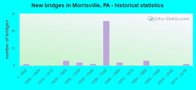
- New bridges - historical statistics
- 1Before 1900
- 31920-1929
- 21930-1939
- 11940-1949
- 261950-1959
- 21960-1969
- 31980-1989
- 12010-2019
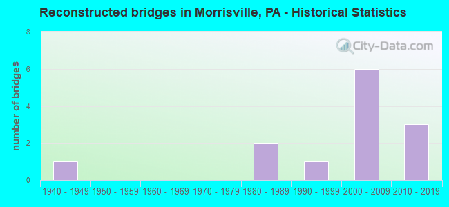
- Reconstructed bridges - Historical Statistics
- 11940-1949
- 01950-1959
- 01960-1969
- 01970-1979
- 21980-1989
- 11990-1999
- 62000-2009
- 32010-2019
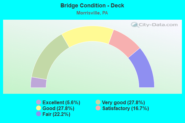
- Bridge Condition - Deck
- 5.6%Excellent
- 27.8%Very good
- 27.8%Good
- 16.7%Satisfactory
- 22.2%Fair
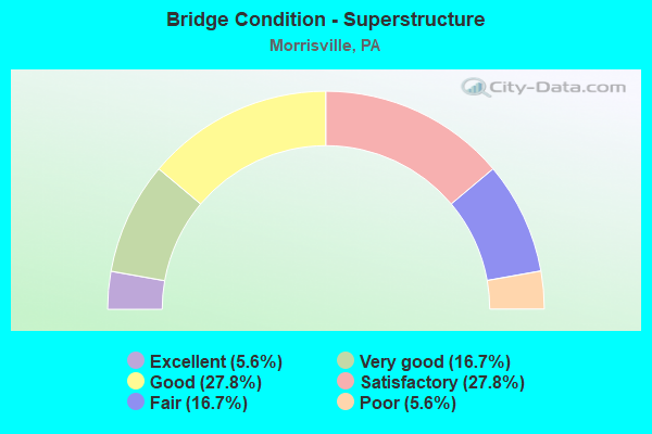
- Bridge Condition - Superstructure
- 5.6%Excellent
- 16.7%Very good
- 27.8%Good
- 27.8%Satisfactory
- 16.7%Fair
- 5.6%Poor
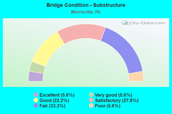
- Bridge Condition - Substructure
- 5.6%Excellent
- 5.6%Very good
- 22.2%Good
- 27.8%Satisfactory
- 33.3%Fair
- 5.6%Poor
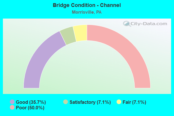
- Bridge Condition - Channel
- 35.7%Good
- 7.1%Satisfactory
- 7.1%Fair
- 50.0%Poor
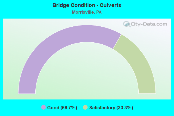
- Bridge Condition - Culverts
- 66.7%Good
- 33.3%Satisfactory
Find on map >> Show street view
Structure Number: 6746, Location: EAST OF ROUTE 13 38K06 (Lat: 40.197028, Lng: -74.798028), Route carried "on" structure: US 1, Year Built: 1954, Year Reconstructed: 1985, Status: Open, Structure Length: 1.04m (3.41ft), Average Daily Traffic: 62,055 (year 2022), Truck Traffic: 8%, Average Future Daily Traffic: 87,717 (year 2032), Design Load: HS 20, Features Intersected: ROCK RUN, Facility Carried by Structure: LINCOLN HWY/RAMPS
Minimum Vertical Clearance: 30+ m (98+ ft), Kilometerpoint: 19.119, Lanes on structure: 3, Base Highway Network: Yes, Owner: State Highway Agency, Approaching Roadway Width: 47.9m (157.2ft), Skew: 30 degrees, Material/Design: Prestressed concrete, Design/Construction: Box Beam or Girders - Single/Spread, Number Of Spans In Main Unit: 1, Length of Maximum Span: 10.1m (33.1ft), Curb or Sidewalk Widths: Left: 0.2m (0.7ft), Right: 0.2m (0.7ft), Curb-To-Curb Width: 47.8m (156.8ft), Out-to-Out Width: 50.7m (166.3ft)
Condition: Deck: Good, Superstructure: Satisfactory, Substructure: Fair, Channel: Poor, Operating Rating: 60.8 metric tons, Method Used To Determine Operating Rating: Load Factor (LF), Inventory Rating: 33.6 metric tons, Method Used To Determine Inventory Rating: Load Factor (LF), Structural Evaluation: Somewhat better than minimum adequacy, Deck Geometry: Superior to present desirable criteria, Waterway Adequacy: Equal to present minimum criteria, Approach Roadway Alignment: Equal to present desirable criteria, Length Of Structure Improvement: 1.70m (5.58ft), Designated Inspection Frequency: Every 24 months, Inspection Date: May 2020, Deck Structure Type: Concrete Cast-file-Place, Wearing Surface/Protective System: Wearing Surface: Monolithic Concrete, Deck Protection: Epoxy Coated Reinforcing
Find on map >> Show street view
Structure Number: 6753, Location: MORRISVILLE 39C05 (Lat: 40.205553, Lng: -74.775197), Route carried "on" structure: US 1, Year Built: 1954, Year Reconstructed: 2006, Status: Open, Structure Length: 18.90m (62.01ft), Average Daily Traffic: 48,936 (year 2022), Truck Traffic: 8%, Average Future Daily Traffic: 66,812 (year 2032), Design Load: HS 20, Features Intersected: DELAWARE CANAL & CONRAIL, Facility Carried by Structure: LINCOLN HIGHWAY
Minimum Vertical Clearance: 30+ m (98+ ft), Kilometerpoint: 20.334, Lanes on structure: 2, Base Highway Network: Yes, Owner: State Highway Agency, Approaching Roadway Width: 21.3m (69.9ft), Skew: 39 degrees, Material/Design: Steel, Design/Construction: Stringer/Multi-beam, Number Of Spans In Main Unit: 5, Length of Maximum Span: 42.7m (140.1ft), Curb or Sidewalk Widths: Left: 0.2m (0.7ft), Right: 0.2m (0.7ft), Curb-To-Curb Width: 16.9m (55.4ft), Out-to-Out Width: 18.8m (61.7ft)
Condition: Deck: Satisfactory, Superstructure: Satisfactory, Substructure: Satisfactory, Channel: Good, Operating Rating: 77.1 metric tons, Method Used To Determine Operating Rating: Load Factor (LF), Inventory Rating: 46.3 metric tons, Method Used To Determine Inventory Rating: Load Factor (LF), Structural Evaluation: Equal to present minimum criteria, Deck Geometry: Superior to present desirable criteria, Underclear: High priority of corrective action, Waterway Adequacy: Superior to present desirable criteria, Approach Roadway Alignment: Better than present minimum criteria, Length Of Structure Improvement: 19.60m (64.30ft), Designated Inspection Frequency: Every 24 months, Critical Feature Inspection Frequency: Every 24 months, Underwater Inspection Frequency: Every 60 months, Inspection Date: July 2020, Critical Feature Inspection Date: July 2020, Underwater Inspection Date: September 2019, Bridge Improvement Cost: $178,000, Roadway Improvement Cost: $524,000, Total Project Cost: $2,402,000, Deck Structure Type: Concrete Cast-file-Place, Wearing Surface/Protective System: Wearing Surface: Latex Concrete, Deck Protection: Epoxy Coated Reinforcing
Find on map >> Show street view
Structure Number: 6779, Location: SNIPES CORNER 39A06 (Lat: 40.198669, Lng: -74.790169), Route carried "on" structure: State highway 32, Year Built: 1954, Year Reconstructed: 1987, Status: Open, Structure Length: 4.57m (14.99ft), Average Daily Traffic: 4,204 (year 2022), Truck Traffic: 5%, Average Future Daily Traffic: 7,911 (year 2032), Design Load: HS 20, Features Intersected: NEW US1 SOUTHBOUND, Facility Carried by Structure: OLD LINCOLN HIGHWY
Minimum Vertical Clearance: 30+ m (98+ ft), Kilometerpoint: 0.000, Lanes on structure: 2, Lanes under structure: 2, Owner: State Highway Agency, Approaching Roadway Width: 15.2m (49.9ft), Skew: 4 degrees, Material/Design: Steel, Design/Construction: Stringer/Multi-beam, Number Of Spans In Main Unit: 1, Number Of Approach Spans: 2, Length of Maximum Span: 20.1m (65.9ft), Curb or Sidewalk Widths: Left: 0.2m (0.7ft), Right: 0.2m (0.7ft), Curb-To-Curb Width: 12.3m (40.4ft), Out-to-Out Width: 13.3m (43.6ft)
Condition: Deck: Satisfactory, Superstructure: Satisfactory, Substructure: Good, Operating Rating: 61.7 metric tons, Method Used To Determine Operating Rating: Load Factor (LF), Inventory Rating: 37.2 metric tons, Method Used To Determine Inventory Rating: Load Factor (LF), Structural Evaluation: Equal to present minimum criteria, Deck Geometry: Better than present minimum criteria, Underclear: High priority of corrective action, Approach Roadway Alignment: Better than present minimum criteria, Length Of Structure Improvement: 5.30m (17.39ft), Designated Inspection Frequency: Every 24 months, Inspection Date: July 2020, Deck Structure Type: Concrete Cast-file-Place, Wearing Surface/Protective System: Wearing Surface: Latex Concrete
Find on map >> Show street view
Structure Number: 7185, Location: 1MI.SE.MORRISVILLE 39A09 (Lat: 40.181608, Lng: -74.788331), Route carried "on" structure: State highway , Year Built: 1954, Year Reconstructed: 2011, Status: Open, Structure Length: 3.51m (11.52ft), Average Daily Traffic: 10,582 (year 2021), Truck Traffic: 30%, Average Future Daily Traffic: 14,835 (year 2032), Design Load: HL 93, Features Intersected: NEWBOLD ROAD, Facility Carried by Structure: TYBURN ROAD
Minimum Vertical Clearance: 30+ m (98+ ft), Kilometerpoint: 3.748, Lanes on structure: 2, Lanes under structure: 2, Owner: State Highway Agency, Approaching Roadway Width: 21.9m (71.9ft), Skew: 20 degrees, Material/Design: Steel continuous, Design/Construction: Stringer/Multi-beam, Number Of Spans In Main Unit: 3, Length of Maximum Span: 15.5m (50.9ft), Curb-To-Curb Width: 20.7m (67.9ft), Out-to-Out Width: 21.8m (71.5ft)
Condition: Deck: Very good, Superstructure: Very good, Substructure: Good, Operating Rating: 95.6 metric tons, Method Used To Determine Operating Rating: Assigned ratings based on Load and Resistance Factor Design (LRFD) reported by rating factor (RF) using HL93 loadings, Inventory Rating: 60.3 metric tons, Method Used To Determine Inventory Rating: Assigned ratings based on Load and Resistance Factor Design (LRFD) reported by rating factor (RF) using HL93 loadings, Structural Evaluation: Better than present minimum criteria, Deck Geometry: Superior to present desirable criteria, Underclear: Meets minimum limits, Approach Roadway Alignment: Equal to present desirable criteria, Length Of Structure Improvement: 4.50m (14.76ft), Designated Inspection Frequency: Every 24 months, Inspection Date: May 2020, Bridge Improvement Cost: $129,000, Roadway Improvement Cost: $381,000, Total Project Cost: $1,745,000, Deck Structure Type: Concrete Cast-file-Place, Wearing Surface/Protective System: Wearing Surface: Monolithic Concrete, Membrane: Other, Deck Protection: Epoxy Coated Reinforcing
Find on map >> Show street view
Structure Number: 7186, Location: 1.5MI.S.MORRISVIL. 39B09 (Lat: 40.182036, Lng: -74.785614), Route carried "on" structure: State highway , Year Built: 1955, Year Reconstructed: 2015, Status: Open, Structure Length: 8.87m (29.10ft), Average Daily Traffic: 11,993 (year 2021), Truck Traffic: 33%, Average Future Daily Traffic: 21,706 (year 2032), Design Load: HL 93, Features Intersected: AMTRAK-NY TO WASH, Facility Carried by Structure: TYBURN RD/BRIST P
Minimum Vertical Clearance: 30+ m (98+ ft), Kilometerpoint: 3.957, Lanes on structure: 2, Owner: State Highway Agency, Approaching Roadway Width: 21.9m (71.9ft), Skew: 22 degrees, Material/Design: Steel continuous, Design/Construction: Stringer/Multi-beam, Number Of Spans In Main Unit: 4, Length of Maximum Span: 31.7m (104.0ft), Curb or Sidewalk Widths: Left: 0.1m (0.3ft), Right: 0.1m (0.3ft), Curb-To-Curb Width: 9.4m (30.8ft), Out-to-Out Width: 21.2m (69.6ft)
Condition: Deck: Very good, Superstructure: Good, Substructure: Good, Operating Rating: 58.0 metric tons, Method Used To Determine Operating Rating: Assigned ratings based on Load and Resistance Factor Design (LRFD) reported by rating factor (RF) using HL93 loadings, Inventory Rating: 36.3 metric tons, Method Used To Determine Inventory Rating: Assigned ratings based on Load and Resistance Factor Design (LRFD) reported by rating factor (RF) using HL93 loadings, Structural Evaluation: Better than present minimum criteria, Deck Geometry: Meets minimum limits, Underclear: High priority of corrective action, Approach Roadway Alignment: Equal to present desirable criteria, Designated Inspection Frequency: Every 24 months, Inspection Date: October 2019, Deck Structure Type: Concrete Cast-file-Place, Wearing Surface/Protective System: Wearing Surface: Monolithic Concrete, Deck Protection: Epoxy Coated Reinforcing
Find on map >> Show street view
Structure Number: 7188, Location: .5MI.S.MORRISVILLE 39B09 (Lat: 40.182681, Lng: -74.781500), Route carried "on" structure: State highway , Year Built: 1955, Year Reconstructed: 2011, Status: Open, Structure Length: 3.93m (12.89ft), Average Daily Traffic: 8,202 (year 2021), Truck Traffic: 42%, Average Future Daily Traffic: 12,638 (year 2032), Design Load: HL 93, Features Intersected: WARNER COMPANY ROAD, Facility Carried by Structure: TYBURN ROAD
Minimum Vertical Clearance: 30+ m (98+ ft), Kilometerpoint: 3.957, Lanes on structure: 2, Lanes under structure: 2, Owner: State Highway Agency, Approaching Roadway Width: 23.2m (76.1ft), Skew: 20 degrees, Material/Design: Steel continuous, Design/Construction: Stringer/Multi-beam, Number Of Spans In Main Unit: 3, Length of Maximum Span: 15.5m (50.9ft), Curb-To-Curb Width: 23.9m (78.4ft), Out-to-Out Width: 24.9m (81.7ft)
Condition: Deck: Very good, Superstructure: Very good, Substructure: Very good, Operating Rating: 70.6 metric tons, Method Used To Determine Operating Rating: Assigned ratings based on Load and Resistance Factor Design (LRFD) reported by rating factor (RF) using HL93 loadings, Inventory Rating: 44.4 metric tons, Method Used To Determine Inventory Rating: Assigned ratings based on Load and Resistance Factor Design (LRFD) reported by rating factor (RF) using HL93 loadings, Structural Evaluation: Equal to present desirable criteria, Deck Geometry: Superior to present desirable criteria, Underclear: High priority of corrective action, Approach Roadway Alignment: Equal to present desirable criteria, Length Of Structure Improvement: 3.90m (12.80ft), Designated Inspection Frequency: Every 24 months, Inspection Date: December 2019, Bridge Improvement Cost: $56,000, Roadway Improvement Cost: $164,000, Total Project Cost: $751,000, Deck Structure Type: Concrete Cast-file-Place, Wearing Surface/Protective System: Wearing Surface: Monolithic Concrete, Membrane: Other, Deck Protection: Epoxy Coated Reinforcing
Find on map >> Show street view
Structure Number: 7198, Location: WEST MORRISVILLE 38G04 (Lat: 40.208886, Lng: -74.818842), Route carried "on" structure: State highway , Year Built: 1955, Status: Open, Structure Length: 1.04m (3.41ft), Average Daily Traffic: 6,380 (year 2021), Truck Traffic: 5%, Average Future Daily Traffic: 8,740 (year 2032), Design Load: HS 20, Features Intersected: ROCK RUN, Facility Carried by Structure: BIG OAK ROAD
Minimum Vertical Clearance: 30+ m (98+ ft), Kilometerpoint: 4.147, Lanes on structure: 2, Owner: State Highway Agency, Approaching Roadway Width: 8.8m (28.9ft), Skew: 3 degrees, Material/Design: Concrete, Design/Construction: Slab, Number Of Spans In Main Unit: 2, Length of Maximum Span: 4.3m (14.1ft), Curb-To-Curb Width: 12.5m (41.0ft), Out-to-Out Width: 12.9m (42.3ft)
Condition: Deck: Fair, Superstructure: Fair, Substructure: Fair, Channel: Poor, Operating Rating: 54.4 metric tons, Method Used To Determine Operating Rating: Load Factor (LF), Inventory Rating: 32.7 metric tons, Method Used To Determine Inventory Rating: Load Factor (LF), Structural Evaluation: Somewhat better than minimum adequacy, Deck Geometry: Somewhat better than minimum adequacy, Waterway Adequacy: Better than present minimum criteria, Approach Roadway Alignment: Equal to present desirable criteria, Length Of Structure Improvement: 1.70m (5.58ft), Designated Inspection Frequency: Every 24 months, Inspection Date: April 2020, Deck Structure Type: Concrete Cast-file-Place, Wearing Surface/Protective System: Wearing Surface: Bituminous
Find on map >> Show street view
Structure Number: 7219, Location: .5MI.NORTH US-1 38H06 (Lat: 40.201850, Lng: -74.809172), Route carried "on" structure: State highway , Year Built: 1920, Year Reconstructed: 1940, Status: Open, Structure Length: 0.85m (2.79ft), Average Daily Traffic: 13,726 (year 2022), Truck Traffic: 5%, Average Future Daily Traffic: 16,346 (year 2032), Design Load: H 15, Features Intersected: ROCK RUN, Facility Carried by Structure: TRENTON AVENUE
Minimum Vertical Clearance: 30+ m (98+ ft), Kilometerpoint: 0.203, Lanes on structure: 2, Owner: State Highway Agency, Approaching Roadway Width: 12.2m (40.0ft), Material/Design: Concrete continuous, Design/Construction: Stringer/Multi-beam, Number Of Spans In Main Unit: 1, Length of Maximum Span: 7.6m (24.9ft), Curb-To-Curb Width: 9.2m (30.2ft), Out-to-Out Width: 10.0m (32.8ft)
Condition: Deck: Fair, Superstructure: Fair, Substructure: Fair, Channel: Poor, Operating Rating: 63.5 metric tons, Method Used To Determine Operating Rating: Field evaluation and documented engineering judgment, Inventory Rating: 31.8 metric tons, Method Used To Determine Inventory Rating: Field evaluation and documented engineering judgment, Structural Evaluation: Somewhat better than minimum adequacy, Deck Geometry: High priority of corrective action, Waterway Adequacy: Somewhat better than minimum adequacy, Approach Roadway Alignment: Equal to present desirable criteria, Length Of Structure Improvement: 1.50m (4.92ft), Designated Inspection Frequency: Every 24 months, Inspection Date: May 2020, Bridge Improvement Cost: $41,000, Roadway Improvement Cost: $120,000, Total Project Cost: $550,000, Deck Structure Type: Concrete Cast-file-Place, Wearing Surface/Protective System: Wearing Surface: Bituminous
Find on map >> Show street view
Structure Number: 722, Location: 1BLK.DELAWARE RIV. 39C03 (Lat: 40.218103, Lng: -74.780128), Route carried "on" structure: State highway , Year Built: 1938, Status: Open, Structure Length: 2.13m (6.99ft), Average Daily Traffic: 12,719 (year 2022), Truck Traffic: 1%, Average Future Daily Traffic: 17,528 (year 2032), Design Load: H 20, Features Intersected: PENNSYLVANIA CANAL, Facility Carried by Structure: EAST TRENTON AVE.
Minimum Vertical Clearance: 30+ m (98+ ft), Kilometerpoint: 3.539, Lanes on structure: 2, Owner: State Highway Agency, Maintenance Responsibility: County Highway Agency, Approaching Roadway Width: 12.2m (40.0ft), Material/Design: Concrete, Design/Construction: Frame, Number Of Spans In Main Unit: 1, Length of Maximum Span: 18.3m (60.0ft), Curb or Sidewalk Widths: Left: 1.5m (4.9ft), Right: 1.6m (5.2ft), Curb-To-Curb Width: 12.2m (40.0ft), Out-to-Out Width: 15.8m (51.8ft)
Condition: Deck: Fair, Superstructure: Fair, Substructure: Fair, Channel: Fair, Operating Rating: 62.6 metric tons, Method Used To Determine Operating Rating: Field evaluation and documented engineering judgment, Inventory Rating: 37.2 metric tons, Method Used To Determine Inventory Rating: Field evaluation and documented engineering judgment, Structural Evaluation: Somewhat better than minimum adequacy, Deck Geometry: Somewhat better than minimum adequacy, Waterway Adequacy: Superior to present desirable criteria, Approach Roadway Alignment: Better than present minimum criteria, Length Of Structure Improvement: 2.80m (9.19ft), Designated Inspection Frequency: Every 24 months, Inspection Date: July 2020, Bridge Improvement Cost: $21,000, Roadway Improvement Cost: $63,000, Total Project Cost: $287,000, Deck Structure Type: Concrete Cast-file-Place, Wearing Surface/Protective System: Wearing Surface: Bituminous
Find on map >> Show street view
Structure Number: 7297, Location: MORRISVILLE BORO. 39D04 (Lat: 40.209828, Lng: -74.772056), Route carried "on" structure: State highway , Year Built: 1942, Status: Open, Structure Length: 0.79m (2.59ft), Average Daily Traffic: 14,331 (year 2020), Truck Traffic: 2%, Average Future Daily Traffic: 40,152 (year 2032), Design Load: H 20, Features Intersected: BRANCH DELAWARE RIVER, Facility Carried by Structure: BRIDGE ST / 3152G7
Minimum Vertical Clearance: 30+ m (98+ ft), Kilometerpoint: 0.000, Lanes on structure: 2, Owner: State Highway Agency, Approaching Roadway Width: 14.3m (46.9ft), Skew: 1 degrees, Material/Design: Masonry, Design/Construction: Culvert, Number Of Spans In Main Unit: 2, Length of Maximum Span: 3.7m (12.1ft)
Condition: Culverts: Satisfactory, Operating Rating: 54.4 metric tons, Method Used To Determine Operating Rating: Field evaluation and documented engineering judgment, Inventory Rating: 32.7 metric tons, Method Used To Determine Inventory Rating: Field evaluation and documented engineering judgment, Structural Evaluation: Equal to present minimum criteria, Waterway Adequacy: Superior to present desirable criteria, Approach Roadway Alignment: Equal to present desirable criteria, Length Of Structure Improvement: 1.40m (4.59ft), Designated Inspection Frequency: Every 24 months, Inspection Date: March 2021
Find on map >> Show street view
Structure Number: 731, Location: .6MI.TO APPL 212 38J06 (Lat: 40.198525, Lng: -74.802542), Route carried "on" structure: State highway , Year Built: 1957, Status: Open, Structure Length: 0.98m (3.22ft), Average Daily Traffic: 13,844 (year 2022), Truck Traffic: 5%, Average Future Daily Traffic: 14,810 (year 2032), Design Load: HS 20, Features Intersected: ROCK RUN, Facility Carried by Structure: PINE GROVE ROAD
Minimum Vertical Clearance: 30+ m (98+ ft), Kilometerpoint: 0.000, Lanes on structure: 2, Owner: State Highway Agency, Approaching Roadway Width: 20.7m (67.9ft), Skew: 20 degrees, Material/Design: Concrete, Design/Construction: Tee Beam, Number Of Spans In Main Unit: 1, Length of Maximum Span: 9.8m (32.2ft)
Condition: Deck: Satisfactory, Superstructure: Satisfactory, Substructure: Fair, Channel: Poor, Operating Rating: 77.1 metric tons, Method Used To Determine Operating Rating: Load Factor (LF), Inventory Rating: 46.3 metric tons, Method Used To Determine Inventory Rating: Load Factor (LF), Structural Evaluation: Somewhat better than minimum adequacy, Waterway Adequacy: Superior to present desirable criteria, Approach Roadway Alignment: Equal to present desirable criteria, Length Of Structure Improvement: 1.60m (5.25ft), Designated Inspection Frequency: Every 24 months, Inspection Date: May 2020
Find on map >> Show street view
Structure Number: 7322, Location: MORRISVILLE BORO. 39C04 (Lat: 40.210108, Lng: -74.776844), Route carried "on" structure: State highway , Year Built: 1930, Status: Open, Structure Length: 2.07m (6.79ft), Average Daily Traffic: 7,027 (year 2022), Truck Traffic: 3%, Average Future Daily Traffic: 10,512 (year 2032), Design Load: H 15, Features Intersected: PENNSYLVANIA CANAL, Facility Carried by Structure: PENNSYLVANIA AVE.
Minimum Vertical Clearance: 30+ m (98+ ft), Kilometerpoint: 3.183, Lanes on structure: 2, Owner: State Highway Agency, Maintenance Responsibility: Railroad, Approaching Roadway Width: 10.7m (35.1ft), Skew: 5 degrees, Material/Design: Steel, Design/Construction: Stringer/Multi-beam, Number Of Spans In Main Unit: 1, Length of Maximum Span: 20.1m (65.9ft), Curb or Sidewalk Widths: Left: 1.7m (5.6ft), Right: 1.7m (5.6ft), Curb-To-Curb Width: 9.4m (30.8ft), Out-to-Out Width: 12.9m (42.3ft)
Condition: Deck: Fair, Superstructure: Poor, Substructure: Poor, Channel: Poor, Operating Rating: 63.5 metric tons, Method Used To Determine Operating Rating: Load Factor (LF), Inventory Rating: 38.1 metric tons, Method Used To Determine Inventory Rating: Load Factor (LF), Structural Evaluation: Meets minimum limits, Deck Geometry: High priority of corrective action, Waterway Adequacy: Superior to present desirable criteria, Approach Roadway Alignment: Equal to present minimum criteria, Length Of Structure Improvement: 2.70m (8.86ft), Designated Inspection Frequency: Every 24 months, Inspection Date: July 2020, Bridge Improvement Cost: $32,000, Roadway Improvement Cost: $95,000, Total Project Cost: $435,000, Deck Structure Type: Concrete Cast-file-Place, Wearing Surface/Protective System: Wearing Surface: Bituminous
Find on map >> Show street view
Structure Number: 7364, Location: WEST OF CHALFONT 27E02 (Lat: 40.290506, Lng: -75.239253), Route carried "on" structure: State highway , Year Built: 1985, Status: Open, Structure Length: 0.98m (3.22ft), Average Daily Traffic: 2,623 (year 2022), Truck Traffic: 4%, Average Future Daily Traffic: 4,577 (year 2032), Design Load: HS 25 or greater, Features Intersected: WALTERS RUN;READING CK., Facility Carried by Structure: NEW GALENA ROAD
Minimum Vertical Clearance: 30+ m (98+ ft), Kilometerpoint: 0.000, Lanes on structure: 2, Owner: State Highway Agency, Approaching Roadway Width: 9.1m (29.9ft), Skew: 1 degrees, Material/Design: Steel, Design/Construction: Culvert, Number Of Spans In Main Unit: 2, Length of Maximum Span: 4.3m (14.1ft)
Condition: Channel: Poor, Culverts: Good, Operating Rating: 42.6 metric tons, Method Used To Determine Operating Rating: Field evaluation and documented engineering judgment, Inventory Rating: 25.4 metric tons, Method Used To Determine Inventory Rating: Field evaluation and documented engineering judgment, Structural Evaluation: Equal to present minimum criteria, Waterway Adequacy: Better than present minimum criteria, Approach Roadway Alignment: Equal to present desirable criteria, Length Of Structure Improvement: 1.50m (4.92ft), Designated Inspection Frequency: Every 24 months, Inspection Date: March 2020
Find on map >> Show street view
Structure Number: 7606, Location: 3152-A8 (Lat: 40.204781, Lng: -74.811342), Route carried "on" structure: City street , Year Built: 1962, Year Reconstructed: 2016, Status: Open, Structure Length: 0.76m (2.49ft), Average Daily Traffic: 1,360 (year 2012), Average Future Daily Traffic: 1,760 (year 2032), Design Load: HL 93, Features Intersected: ROCK RUN, Facility Carried by Structure: ALDEN AVENUE
Minimum Vertical Clearance: 30+ m (98+ ft), Kilometerpoint: 0.000, Lanes on structure: 2, Owner: Town or Township Highway Agency, Approaching Roadway Width: 10.7m (35.1ft), Material/Design: Prestressed concrete, Design/Construction: Box Beam or Girders - Multiple, Number Of Spans In Main Unit: 1, Length of Maximum Span: 7.0m (23.0ft), Curb or Sidewalk Widths: Left: 1.7m (5.6ft), Right: 1.7m (5.6ft), Curb-To-Curb Width: 10.4m (34.1ft), Out-to-Out Width: 13.8m (45.3ft)
Condition: Deck: Very good, Superstructure: Very good, Substructure: Fair, Channel: Poor, Operating Rating: 50.5 metric tons, Method Used To Determine Operating Rating: Assigned ratings based on Load and Resistance Factor Design (LRFD) reported by rating factor (RF) using HL93 loadings, Inventory Rating: 33.7 metric tons, Method Used To Determine Inventory Rating: Assigned ratings based on Load and Resistance Factor Design (LRFD) reported by rating factor (RF) using HL93 loadings, Structural Evaluation: Somewhat better than minimum adequacy, Deck Geometry: Equal to present minimum criteria, Waterway Adequacy: Better than present minimum criteria, Approach Roadway Alignment: Equal to present desirable criteria, Length Of Structure Improvement: 1.50m (4.92ft), Designated Inspection Frequency: Every 24 months, Inspection Date: September 2020, Deck Structure Type: Concrete Cast-file-Place, Wearing Surface/Protective System: Wearing Surface: Bituminous, Deck Protection: Epoxy Coated Reinforcing
Find on map >> Show street view
Structure Number: 7685, Location: MORRISVILLE BORO. 39D04 (Lat: 40.208300, Lng: -74.768300), Route carried "on" structure: US 1, Year Built: 1952, Year Reconstructed: 2009, Status: Open, Structure Length: 40.39m (132.51ft), Average Daily Traffic: 47,400 (year 2020), Truck Traffic: 7%, Average Future Daily Traffic: 54,300 (year 2040), Design Load: HS 20, Features Intersected: PA32,NJ29SB,NSRC,DELR
Minimum Vertical Clearance: 5.73m (18.80ft), Kilometerpoint: 0.000, Lanes on structure: 6, Lanes under structure: 5, Base Highway Network: Yes, Toll: Toll bridge, Owner: Local Toll Authority, Maintenance Responsibility: Private, Approaching Roadway Width: 23.2m (76.1ft), Skew: 31 degrees, Material/Design: Steel, Design/Construction: Stringer/Multi-beam, Number Of Spans In Main Unit: 12, Length of Maximum Span: 34.1m (111.9ft), Curb-To-Curb Width: 23.2m (76.1ft), Out-to-Out Width: 25.1m (82.3ft)
Condition: Deck: Good, Superstructure: Good, Substructure: Satisfactory, Channel: Good, Operating Rating: 68.0 metric tons, Method Used To Determine Operating Rating: Load Factor (LF), Inventory Rating: 40.8 metric tons, Method Used To Determine Inventory Rating: Load Factor (LF), Structural Evaluation: Equal to present minimum criteria, Deck Geometry: Meets minimum limits, Underclear: High priority of corrective action, Waterway Adequacy: Equal to present desirable criteria, Approach Roadway Alignment: Equal to present desirable criteria, Length Of Structure Improvement: 41.00m (134.51ft), Designated Inspection Frequency: Every 24 months, Underwater Inspection Frequency: Every 24 months, Inspection Date: June 2021, Underwater Inspection Date: November 2016, Deck Structure Type: Concrete Cast-file-Place, Wearing Surface/Protective System: Wearing Surface: Monolithic Concrete, Deck Protection: Epoxy Coated Reinforcing
Find on map >> Show street view
Structure Number: 7686, Location: MORRISVILLE BOROUGH (Lat: 40.205800, Lng: -74.774600), Route carried "on" structure: US 1, Year Built: 1952, Year Reconstructed: 2009, Status: Open, Structure Length: 1.74m (5.71ft), Average Daily Traffic: 47,400 (year 2020), Truck Traffic: 7%, Average Future Daily Traffic: 53,900 (year 2040), Design Load: HS 20, Features Intersected: WASHINGTON ST.
Minimum Vertical Clearance: 30+ m (98+ ft), Kilometerpoint: 20.390, Lanes on structure: 6, Lanes under structure: 2, Base Highway Network: Yes, Toll: Toll bridge, Owner: Local Toll Authority, Maintenance Responsibility: Private, Approaching Roadway Width: 24.4m (80.1ft), Skew: 30 degrees, Material/Design: Steel, Design/Construction: Stringer/Multi-beam, Number Of Spans In Main Unit: 1, Length of Maximum Span: 16.2m (53.1ft), Curb-To-Curb Width: 36.3m (119.1ft), Out-to-Out Width: 38.1m (125.0ft)
Condition: Deck: Very good, Superstructure: Good, Substructure: Satisfactory, Operating Rating: 87.1 metric tons, Method Used To Determine Operating Rating: Load Factor (LF), Inventory Rating: 52.6 metric tons, Method Used To Determine Inventory Rating: Load Factor (LF), Structural Evaluation: Equal to present minimum criteria, Deck Geometry: High priority of corrective action, Underclear: Somewhat better than minimum adequacy, Approach Roadway Alignment: Equal to present desirable criteria, Length Of Structure Improvement: 2.40m (7.87ft), Designated Inspection Frequency: Every 24 months, Inspection Date: June 2021, Deck Structure Type: Concrete Cast-file-Place, Wearing Surface/Protective System: Wearing Surface: Monolithic Concrete, Deck Protection: Epoxy Coated Reinforcing
Find on map >> Show street view
Structure Number: 7687, Location: MORRISVILLE BORO. 39C04 (Lat: 40.204997, Lng: -74.775000), Route carried "on" structure: US 1, Year Built: 1952, Year Reconstructed: 2009, Status: Open, Structure Length: 2.07m (6.79ft), Average Daily Traffic: 47,400 (year 2020), Truck Traffic: 7%, Average Future Daily Traffic: 53,900 (year 2040), Design Load: HS 20, Features Intersected: S. PENNA. AVE.
Minimum Vertical Clearance: 30+ m (98+ ft), Kilometerpoint: 0.000, Lanes on structure: 6, Lanes under structure: 4, Base Highway Network: Yes, Owner: Local Toll Authority, Maintenance Responsibility: Private, Approaching Roadway Width: 24.4m (80.1ft), Skew: 31 degrees, Material/Design: Steel, Design/Construction: Stringer/Multi-beam, Number Of Spans In Main Unit: 1, Length of Maximum Span: 19.5m (64.0ft), Curb-To-Curb Width: 24.4m (80.1ft), Out-to-Out Width: 26.8m (87.9ft)
Condition: Deck: Good, Superstructure: Good, Substructure: Good, Operating Rating: 88.0 metric tons, Method Used To Determine Operating Rating: Load Factor (LF), Inventory Rating: 52.6 metric tons, Method Used To Determine Inventory Rating: Load Factor (LF), Structural Evaluation: Better than present minimum criteria, Deck Geometry: Meets minimum limits, Underclear: High priority of corrective action, Approach Roadway Alignment: Equal to present desirable criteria, Length Of Structure Improvement: 2.70m (8.86ft), Designated Inspection Frequency: Every 24 months, Inspection Date: June 2021, Deck Structure Type: Concrete Cast-file-Place, Wearing Surface/Protective System: Wearing Surface: Monolithic Concrete, Deck Protection: Epoxy Coated Reinforcing
Find on map >> Show street view
Structure Number: 7688, Location: MORRISVILLE BORO. 39D04 (Lat: 40.210428, Lng: -74.768550), Route carried "on" structure: State highway 2060, Year Built: 1928, Year Reconstructed: 1997, Status: Posted for load, Structure Length: 31.12m (102.10ft), Average Daily Traffic: 14,200 (year 2020), Average Future Daily Traffic: 16,900 (year 2040), Design Load: HS 20, Features Intersected: DELAWARE RIV & NJ 29 SB, Facility Carried by Structure: Bridge Street
Minimum Vertical Clearance: 6.04m (19.82ft), Kilometerpoint: 0.000, Lanes on structure: 2, Lanes under structure: 3, Owner: Local Toll Authority, Approaching Roadway Width: 14.6m (47.9ft), Skew: 30 degrees, Material/Design: Steel, Design/Construction: Truss - Thru, Number Of Spans In Main Unit: 5, Length of Maximum Span: 64.0m (210.0ft), Curb or Sidewalk Widths: Left: 2.4m (7.9ft), Right: 0.0m, Curb-To-Curb Width: 12.2m (40.0ft), Out-to-Out Width: 13.4m (44.0ft)
Condition: Deck: Good, Superstructure: Satisfactory, Substructure: Satisfactory, Channel: Good, Operating Rating: 50.8 metric tons, Method Used To Determine Operating Rating: Allowable Stress (AS), Inventory Rating: 34.5 metric tons, Method Used To Determine Inventory Rating: Allowable Stress (AS), Structural Evaluation: Equal to present minimum criteria, Deck Geometry: Somewhat better than minimum adequacy, Underclear: Equal to present minimum criteria, Waterway Adequacy: Equal to present desirable criteria, Approach Roadway Alignment: Equal to present minimum criteria, Length Of Structure Improvement: 31.70m (104.00ft), Designated Inspection Frequency: Every 24 months, Critical Feature Inspection Frequency: Every 24 months, Underwater Inspection Frequency: Every 60 months, Other Special Inspection Frequency: Every 12 months, Inspection Date: April 2020, Critical Feature Inspection Date: April 2020, Underwater Inspection Date: November 2016, Other Special Inspection Date: April 2021, Bridge Improvement Cost: $259,000, Roadway Improvement Cost: $763,000, Total Project Cost: $3,498,000, Deck Structure Type: Open Grating
Find on map >> Show street view
Structure Number: 7689, Location: MORRISVILLE BORO. 39D04 (Lat: 40.219711, Lng: -74.778342), Route carried "on" structure: City street , Year Built: 1884, Year Reconstructed: 2010, Status: Posted for load, Structure Length: 38.92m (127.69ft), Average Daily Traffic: 13,200 (year 2020), Average Future Daily Traffic: 16,700 (year 2040), Features Intersected: DELAWARE RIVER, Facility Carried by Structure: CONNECT PA32&NJ29
Minimum Vertical Clearance: 3.73m (12.24ft), Kilometerpoint: 0.000, Lanes on structure: 2, Owner: Local Toll Authority, Approaching Roadway Width: 5.5m (18.0ft), Material/Design: Aluminum, Iron, Design/Construction: Truss - Thru, Number Of Spans In Main Unit: 7, Length of Maximum Span: 54.9m (180.1ft), Curb or Sidewalk Widths: Left: 1.8m (5.9ft), Right: 0.0m, Curb-To-Curb Width: 5.6m (18.4ft), Out-to-Out Width: 6.3m (20.7ft)
Condition: Deck: Good, Superstructure: Good, Substructure: Satisfactory, Channel: Good, Operating Rating: 32.7 metric tons, Method Used To Determine Operating Rating: Allowable Stress (AS), Inventory Rating: 20.9 metric tons, Method Used To Determine Inventory Rating: Allowable Stress (AS), Structural Evaluation: Somewhat better than minimum adequacy, Deck Geometry: High priority of replacement, Waterway Adequacy: Equal to present desirable criteria, Approach Roadway Alignment: Meets minimum limits, Bridge Posting: Required (Relationship of Operating Rating to Maximum Legal Load: 20.0 - 29.9% below), Length Of Structure Improvement: 48.60m (159.45ft), Designated Inspection Frequency: Every 24 months, Critical Feature Inspection Frequency: Every 24 months, Underwater Inspection Frequency: Every 60 months, Other Special Inspection Frequency: Every 12 months, Inspection Date: April 2020, Critical Feature Inspection Date: April 2020, Underwater Inspection Date: November 2016, Other Special Inspection Date: April 2021, Bridge Improvement Cost: $836,000, Roadway Improvement Cost: $2,462,000, Total Project Cost: $11,286,000, Deck Structure Type: Open Grating
Find on map >> Show street view
Structure Number: 18086, Location: FRANKLIN TOWNSHIP (Lat: 39.897494, Lng: -80.158642), Route carried "on" structure: State highway 21, Year Built: 1966, Status: Open, Structure Length: 0.79m (2.59ft), Average Daily Traffic: 14,537 (year 2021), Truck Traffic: 19%, Average Future Daily Traffic: 19,287 (year 2032), Design Load: H 20, Features Intersected: LAUREL RUN
Minimum Vertical Clearance: 30+ m (98+ ft), Kilometerpoint: 28.341, Lanes on structure: 4, Base Highway Network: Yes, Owner: State Highway Agency, Approaching Roadway Width: 11.0m (36.1ft), Material/Design: Concrete, Design/Construction: Culvert, Number Of Spans In Main Unit: 1, Length of Maximum Span: 7.9m (25.9ft)
Condition: Channel: Satisfactory, Culverts: Good, Inventory Rating: 99.8 metric tons, Method Used To Determine Inventory Rating: Field evaluation and documented engineering judgment, Structural Evaluation: Better than present minimum criteria, Waterway Adequacy: Superior to present desirable criteria, Approach Roadway Alignment: Equal to present desirable criteria, Length Of Structure Improvement: 1.40m (4.59ft), Designated Inspection Frequency: Every 48 months, Inspection Date: August 2018
Find on map >> Show street view
Structure Number: 54456, Location: 0.3 mi N from SR 0188 (Lat: 39.896483, Lng: -80.170156), Route carried "on" structure: US 19, Year Built: 2017, Status: Open, Structure Length: 4.79m (15.72ft), Average Daily Traffic: 16,452 (year 2020), Truck Traffic: 7%, Average Future Daily Traffic: 28,000 (year 2036), Design Load: HL 93, Features Intersected: Ten Mile Creek
Minimum Vertical Clearance: 30+ m (98+ ft), Kilometerpoint: 25.138, Lanes on structure: 4, Base Highway Network: Yes, Owner: State Highway Agency, Approaching Roadway Width: 7.3m (24.0ft), Skew: 23 degrees, Material/Design: Prestressed concrete continuous, Design/Construction: Stringer/Multi-beam, Number Of Spans In Main Unit: 2, Length of Maximum Span: 23.5m (77.1ft), Curb or Sidewalk Widths: Left: 1.5m (4.9ft), Right: 3.5m (11.5ft), Curb-To-Curb Width: 21.1m (69.2ft), Out-to-Out Width: 26.9m (88.3ft)
Condition: Deck: Excellent, Superstructure: Excellent, Substructure: Excellent, Channel: Good, Operating Rating: 59.9 metric tons, Method Used To Determine Operating Rating: Assigned ratings based on Load and Resistance Factor Design (LRFD) reported by rating factor (RF) using HL93 loadings, Inventory Rating: 37.6 metric tons, Method Used To Determine Inventory Rating: Assigned ratings based on Load and Resistance Factor Design (LRFD) reported by rating factor (RF) using HL93 loadings, Structural Evaluation: Superior to present desirable criteria, Deck Geometry: Superior to present desirable criteria, Waterway Adequacy: Equal to present minimum criteria, Approach Roadway Alignment: Better than present minimum criteria, Designated Inspection Frequency: Every 24 months, Inspection Date: August 2020, Deck Structure Type: Concrete Cast-file-Place, Wearing Surface/Protective System: Wearing Surface: Monolithic Concrete, Deck Protection: Epoxy Coated Reinforcing
Find on map >> Show street view
Structure Number: 6751, Location: S.BRIDGE STREET 39B06 (Lat: 40.200000, Lng: -74.784583), Route carried "under" structure: US 1, Year Built: 1985, Structure Length: 0. m, Average Daily Traffic: 27,288 (year 2022), Truck Traffic: 7%, Features Intersected: U S ROUTE 1, Facility Carried by Structure: SERVICE ROAD
Minimum Vertical Clearance: 4.44m (14.57ft), Kilometerpoint: 20.334, Lanes on structure: 2, Lanes under structure: 2, Material/Design: Prestressed concrete, Design/Construction: Box Beam or Girders - Multiple, Length of Maximum Span: 33.8m (110.9ft)
Find on map >> Show street view
Structure Number: 6751, Location: S.BRIDGE STREET 39B06 (Lat: 40.200000, Lng: -74.784583), Route carried "under" structure: US 1, Year Built: 1985, Structure Length: 0. m, Average Daily Traffic: 21,648 (year 2022), Truck Traffic: 9%, Features Intersected: U S ROUTE 1, Facility Carried by Structure: SERVICE ROAD
Minimum Vertical Clearance: 4.44m (14.57ft), Kilometerpoint: 20.352, Lanes on structure: 2, Lanes under structure: 2, Material/Design: Prestressed concrete, Design/Construction: Box Beam or Girders - Multiple, Length of Maximum Span: 33.8m (110.9ft)
Find on map >> Show street view
Structure Number: 6774, Location: 1MI.S.MORRISVILL 38J07 (Lat: 40.194372, Lng: -74.801458), Route carried "under" structure: State highway , Year Built: 1954, Structure Length: 0. m, Average Daily Traffic: 1,220 (year 2021), Truck Traffic: 12%, Features Intersected: NEWBOLD ROAD & Conrail, Facility Carried by Structure: TRAFFIC ROUTE 13
Minimum Vertical Clearance: 6.99m (22.93ft), Kilometerpoint: 1.621, Lanes on structure: 2, Lanes under structure: 2, Material/Design: Steel continuous, Design/Construction: Stringer/Multi-beam, Length of Maximum Span: 38.1m (125.0ft)
Find on map >> Show street view
Structure Number: 6776, Location: 1MI.W.MORRISVILLE 38J06 (Lat: 40.196625, Lng: -74.801983), Route carried "under" structure: Ramp State highway , Year Built: 1954, Structure Length: 0. m, Average Daily Traffic: 1,580 (year 2022), Truck Traffic: 8%, Features Intersected: US 1, Facility Carried by Structure: TRAFFIC ROUTE 13
Minimum Vertical Clearance: 4.55m (14.93ft), Kilometerpoint: 0.000, Lanes on structure: 2, Lanes under structure: 1, Material/Design: Steel, Design/Construction: Stringer/Multi-beam, Length of Maximum Span: 25.6m (84.0ft)
Find on map >> Show street view
Structure Number: 6776, Location: 1MI.W.MORRISVILLE 38J06 (Lat: 40.196625, Lng: -74.801983), Route carried "under" structure: Ramp State highway , Year Built: 1954, Structure Length: 0. m, Average Daily Traffic: 13,119 (year 2022), Truck Traffic: 8%, Features Intersected: US 1, Facility Carried by Structure: TRAFFIC ROUTE 13
Minimum Vertical Clearance: 4.62m (15.16ft), Kilometerpoint: 1.786, Lanes on structure: 2, Lanes under structure: 1, Material/Design: Steel, Design/Construction: Stringer/Multi-beam, Length of Maximum Span: 25.6m (84.0ft)
Find on map >> Show street view
Structure Number: 6776, Location: 1MI.W.MORRISVILLE 38J06 (Lat: 40.196625, Lng: -74.801983), Route carried "under" structure: US 1, Year Built: 1954, Structure Length: 0. m, Average Daily Traffic: 27,288 (year 2022), Truck Traffic: 7%, Features Intersected: US 1
Minimum Vertical Clearance: 4.62m (15.16ft), Kilometerpoint: 18.269, Lanes on structure: 2, Lanes under structure: 2, Material/Design: Steel, Design/Construction: Stringer/Multi-beam, Length of Maximum Span: 25.6m (84.0ft)
Find on map >> Show street view
Structure Number: 6776, Location: 1MI.W.MORRISVILLE 38J06 (Lat: 40.196625, Lng: -74.801983), Route carried "under" structure: US 1, Year Built: 1954, Structure Length: 0. m, Average Daily Traffic: 21,648 (year 2022), Truck Traffic: 9%, Features Intersected: US 1
Minimum Vertical Clearance: 4.47m (14.67ft), Kilometerpoint: 18.289, Lanes on structure: 2, Lanes under structure: 2, Material/Design: Steel, Design/Construction: Stringer/Multi-beam, Length of Maximum Span: 25.6m (84.0ft)
Find on map >> Show street view
Structure Number: 6779, Location: SNIPES CORNER 39A06 (Lat: 40.198669, Lng: -74.790169), Route carried "under" structure: US 1, Year Built: 1954, Structure Length: 0. m, Average Daily Traffic: 21,648 (year 2022), Truck Traffic: 9%, Features Intersected: NEW US1 SOUTHBOUND, Facility Carried by Structure: OLD LINCOLN HIGHWY
Minimum Vertical Clearance: 4.47m (14.67ft), Kilometerpoint: 19.850, Lanes on structure: 2, Lanes under structure: 2, Material/Design: Steel, Design/Construction: Stringer/Multi-beam, Length of Maximum Span: 20.1m (65.9ft)
Find on map >> Show street view
Structure Number: 7185, Location: 1MI.SE.MORRISVILLE 39A09 (Lat: 40.181608, Lng: -74.788331), Route carried "under" structure: State highway , Year Built: 1954, Structure Length: 0. m, Average Daily Traffic: 1,855 (year 2021), Truck Traffic: 24%, Features Intersected: NEWBOLD ROAD, Facility Carried by Structure: TYBURN ROAD
Minimum Vertical Clearance: 4.47m (14.67ft), Kilometerpoint: 0.000, Lanes on structure: 2, Lanes under structure: 1, Material/Design: Steel continuous, Design/Construction: Stringer/Multi-beam, Length of Maximum Span: 15.5m (50.9ft)
Find on map >> Show street view
Structure Number: 7185, Location: 1MI.SE.MORRISVILLE 39A09 (Lat: 40.181608, Lng: -74.788331), Route carried "under" structure: State highway , Year Built: 1954, Structure Length: 0. m, Average Daily Traffic: 1,855 (year 2021), Truck Traffic: 24%, Features Intersected: NEWBOLD ROAD, Facility Carried by Structure: TYBURN ROAD
Minimum Vertical Clearance: 4.67m (15.32ft), Kilometerpoint: 0.000, Lanes on structure: 2, Lanes under structure: 1, Material/Design: Steel continuous, Design/Construction: Stringer/Multi-beam, Length of Maximum Span: 15.5m (50.9ft)
Find on map >> Show street view
Structure Number: 7187, Location: .5MI.S.MORRISVILLE 39B09 (Lat: 40.182556, Lng: -74.782492), Route carried "under" structure: Ramp State highway , Year Built: 1954, Structure Length: 0. m, Average Daily Traffic: 2,433 (year 2022), Truck Traffic: 21%, Features Intersected: RAMP G, Facility Carried by Structure: TYBURN ROAD
Minimum Vertical Clearance: 4.60m (15.09ft), Kilometerpoint: 4.976, Lanes on structure: 2, Lanes under structure: 1, Material/Design: Steel continuous, Design/Construction: Stringer/Multi-beam, Length of Maximum Span: 16.8m (55.1ft)
Find on map >> Show street view
Structure Number: 7187, Location: .5MI.S.MORRISVILLE 39B09 (Lat: 40.182556, Lng: -74.782492), Route carried "under" structure: Ramp State highway , Year Built: 1954, Structure Length: 0. m, Average Daily Traffic: 2,433 (year 2022), Truck Traffic: 21%, Features Intersected: RAMP G, Facility Carried by Structure: TYBURN ROAD
Minimum Vertical Clearance: 4.82m (15.81ft), Kilometerpoint: 4.976, Lanes on structure: 2, Lanes under structure: 1, Material/Design: Steel continuous, Design/Construction: Stringer/Multi-beam, Length of Maximum Span: 16.8m (55.1ft)
Find on map >> Show street view
Structure Number: 7188, Location: .5MI.S.MORRISVILLE 39B09 (Lat: 40.182681, Lng: -74.781500), Route carried "under" structure: State highway , Year Built: 1955, Structure Length: 0. m, Average Daily Traffic: 50 (year 1980), Features Intersected: WARNER COMPANY ROAD, Facility Carried by Structure: TYBURN ROAD
Minimum Vertical Clearance: 5.77m (18.93ft), Kilometerpoint: 0.000, Lanes on structure: 2, Lanes under structure: 2, Material/Design: Steel continuous, Design/Construction: Stringer/Multi-beam, Length of Maximum Span: 15.5m (50.9ft)
Find on map >> Show street view
Structure Number: 7685, Location: MORRISVILLE BORO. 39D04 (Lat: 40.208300, Lng: -74.768300), Route carried "under" structure: City street , Year Built: 1952, Structure Length: 0. m, Average Daily Traffic: 500 (year 2019), Features Intersected: PA32,NJ29SB,NSRC,DELR, Facility Carried by Structure: US 1
Minimum Vertical Clearance: 7.92m (25.98ft), Kilometerpoint: 0.000, Lanes on structure: 6, Lanes under structure: 2, Material/Design: Steel, Design/Construction: Stringer/Multi-beam, Length of Maximum Span: 34.1m (111.9ft)
Find on map >> Show street view
Structure Number: 7685, Location: MORRISVILLE BORO. 39D04 (Lat: 40.208300, Lng: -74.768300), Route carried "under" structure: State highway 29, Year Built: 1952, Structure Length: 0. m, Average Daily Traffic: 25,211 (year 2018), Truck Traffic: 5%, Features Intersected: PA32,NJ29SB,NSRC,DELR, Facility Carried by Structure: US 1
Minimum Vertical Clearance: 5.27m (17.29ft), Kilometerpoint: 5.423, Lanes on structure: 6, Lanes under structure: 3, Material/Design: Steel, Design/Construction: Stringer/Multi-beam, Length of Maximum Span: 34.1m (111.9ft)
Find on map >> Show street view
Structure Number: 7686, Location: MORRISVILLE BOROUGH (Lat: 40.205800, Lng: -74.774600), Route carried "under" structure: City street , Year Built: 1952, Structure Length: 0. m, Average Daily Traffic: 5,000 (year 2017), Truck Traffic: 1%, Features Intersected: WASHINGTON ST., Facility Carried by Structure: US 1
Minimum Vertical Clearance: 4.48m (14.70ft), Kilometerpoint: 0.000, Lanes on structure: 6, Lanes under structure: 2, Toll: Toll bridge, Material/Design: Steel, Design/Construction: Stringer/Multi-beam, Length of Maximum Span: 16.2m (53.1ft)
Find on map >> Show street view
Structure Number: 7687, Location: MORRISVILLE BORO. 39C04 (Lat: 40.204997, Lng: -74.775000), Route carried "under" structure: State highway , Year Built: 1952, Structure Length: 0. m, Average Daily Traffic: 7,575 (year 2020), Truck Traffic: 13%, Features Intersected: S. PENNA. AVE., Facility Carried by Structure: US 1
Minimum Vertical Clearance: 4.65m (15.26ft), Kilometerpoint: 2.602, Lanes on structure: 6, Lanes under structure: 4, Material/Design: Steel, Design/Construction: Stringer/Multi-beam, Length of Maximum Span: 19.5m (64.0ft)
Find on map >> Show street view
Structure Number: 7688, Location: MORRISVILLE BORO. 39D04 (Lat: 40.210428, Lng: -74.768550), Route carried "under" structure: State highway 29, Year Built: 1928, Structure Length: 0. m, Average Daily Traffic: 22,120 (year 2016), Truck Traffic: 4%, Features Intersected: DELAWARE RIV & NJ 29 SB, Facility Carried by Structure: Bridge Street
Minimum Vertical Clearance: 4.50m (14.76ft), Kilometerpoint: 0.000, Lanes on structure: 2, Lanes under structure: 3, Material/Design: Steel, Design/Construction: Truss - Thru, Length of Maximum Span: 64.0m (210.0ft)