Bridge Statistics for Moundville, Alabama (AL)
Condition, Traffic, Stress, Structural Evaluation, Project Costs
- National Bridge Inventory (NBI) Statistics
- 22Number of bridges
- 292ft / 89.3mTotal length
- $32,668,000Total costs
- 71,395Total average daily traffic
- 6,811Total average daily truck traffic
- 99,627Total future (year 2032) average daily traffic
- National Bridge Inventory (NBI) Registered Bridges for Moundville
- No street view available for this location
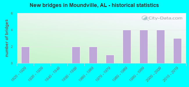
- New bridges - historical statistics
- 21920-1929
- 21950-1959
- 21960-1969
- 11970-1979
- 41980-1989
- 41990-1999
- 42000-2009
- 32010-2019

- Reconstructed bridges - Historical Statistics
- 11970-1979
- 11980-1989


- Bridge Condition - Deck
- 8.3%Excellent
- 33.3%Very good
- 33.3%Good
- 25.0%Satisfactory

- Bridge Condition - Superstructure
- 8.3%Excellent
- 41.7%Very good
- 33.3%Good
- 8.3%Satisfactory
- 8.3%Fair

- Bridge Condition - Substructure
- 8.3%Excellent
- 25.0%Very good
- 50.0%Good
- 8.3%Satisfactory
- 8.3%Fair

- Bridge Condition - Channel
- 27.3%Very good
- 13.6%Good
- 40.9%Satisfactory
- 13.6%Fair
- 4.5%Poor

- Bridge Condition - Culverts
- 10.0%Very good
- 50.0%Good
- 40.0%Satisfactory
Find on map >> Show street view
Structure Number: 676, Location: 2.4 MI N OF HAVANA (Lat: 32.924250, Lng: -87.637333), Route carried "on" structure: State highway 69, Year Built: 1929, Status: Open, Structure Length: 0.64m (2.10ft), Average Daily Traffic: 7,960 (year 2016), Truck Traffic: 12%, Average Future Daily Traffic: 10,347 (year 2041), Design Load: H 15, Features Intersected: GILE CREEK
Minimum Vertical Clearance: 30+ m (98+ ft), Kilometerpoint: 200.787, Lanes on structure: 2, Base Highway Network: Yes, Owner: State Highway Agency, Approaching Roadway Width: 9.8m (32.2ft), Material/Design: Concrete, Design/Construction: Culvert, Number Of Spans In Main Unit: 2, Length of Maximum Span: 3.0m (9.8ft)
Condition: Channel: Satisfactory, Culverts: Satisfactory, Operating Rating: 88.9 metric tons, Method Used To Determine Operating Rating: Load Factor (LF), Inventory Rating: 59.8 metric tons, Method Used To Determine Inventory Rating: Load Factor (LF), Structural Evaluation: Equal to present minimum criteria, Waterway Adequacy: Equal to present minimum criteria, Approach Roadway Alignment: Equal to present desirable criteria, Length Of Structure Improvement: 1.26m (4.13ft), Designated Inspection Frequency: Every 24 months, Inspection Date: December 2021, Bridge Improvement Cost: $262,000, Roadway Improvement Cost: $26,000, Total Project Cost: $288,000 ( Estimate for 2022)
Find on map >> Show street view
Structure Number: 5873, Location: 0.3 MILE W. OF POWERS (Lat: 32.970000, Lng: -87.658333), Route carried "on" structure: County highway 21, Year Built: 1957, Year Reconstructed: 1991, Status: Open, Structure Length: 2.19m (7.19ft), Average Daily Traffic: 150 (year 1989), Truck Traffic: 1%, Average Future Daily Traffic: 400 (year 2034), Design Load: H 15, Features Intersected: TRIB. TO WILLIAMS CREEK
Minimum Vertical Clearance: 30+ m (98+ ft), Kilometerpoint: 0.010, Lanes on structure: 2, Owner: County Highway Agency, Approaching Roadway Width: 8.5m (27.9ft), Skew: 4 degrees, Material/Design: Concrete, Design/Construction: Culvert, Number Of Spans In Main Unit: 4, Length of Maximum Span: 4.9m (16.1ft), Curb-To-Curb Width: 14.2m (46.6ft), Out-to-Out Width: 14.7m (48.2ft)
Condition: Channel: Satisfactory, Culverts: Satisfactory, Operating Rating: 84.5 metric tons, Method Used To Determine Operating Rating: Load Factor (LF), Inventory Rating: 50.7 metric tons, Method Used To Determine Inventory Rating: Load Factor (LF), Structural Evaluation: Equal to present minimum criteria, Deck Geometry: Superior to present desirable criteria, Waterway Adequacy: Better than present minimum criteria, Approach Roadway Alignment: Equal to present minimum criteria, Length Of Structure Improvement: 2.99m (9.81ft), Designated Inspection Frequency: Every 24 months, Inspection Date: January 2022, Bridge Improvement Cost: $1,123,000, Roadway Improvement Cost: $112,000, Total Project Cost: $1,235,000 ( Estimate for 2022)
Find on map >> Show street view
Structure Number: 6065, Location: 0.9 MI NE OF JCT NEW N 69 (Lat: 33.024719, Lng: -87.587081), Route carried "on" structure: County highway 300, Year Built: 1957, Status: Open, Structure Length: 0.64m (2.10ft), Average Daily Traffic: 200 (year 1996), Truck Traffic: 5%, Average Future Daily Traffic: 250 (year 2035), Design Load: HS 20, Features Intersected: RICE BRANCH, Facility Carried by Structure: OLD GREENSBORO RD
Minimum Vertical Clearance: 7.56m (24.80ft), Kilometerpoint: 0.010, Lanes on structure: 2, Owner: County Highway Agency, Approaching Roadway Width: 6.1m (20.0ft), Material/Design: Concrete, Design/Construction: Culvert, Number Of Spans In Main Unit: 3, Length of Maximum Span: 2.0m (6.6ft)
Condition: Channel: Fair, Culverts: Good, Operating Rating: 34.1 metric tons, Method Used To Determine Operating Rating: Load Factor (LF), Inventory Rating: 20.5 metric tons, Method Used To Determine Inventory Rating: Load Factor (LF), Structural Evaluation: Somewhat better than minimum adequacy, Waterway Adequacy: Better than present minimum criteria, Approach Roadway Alignment: Better than present minimum criteria, Length Of Structure Improvement: 1.26m (4.13ft), Designated Inspection Frequency: Every 24 months, Inspection Date: December 2021, Bridge Improvement Cost: $233,000, Roadway Improvement Cost: $23,000, Total Project Cost: $256,000 ( Estimate for 2022), Deck Structure Type: Concrete Cast-file-Place, Wearing Surface/Protective System: Wearing Surface: Bituminous
Find on map >> Show street view
Structure Number: 8358, Location: 0.9 MI. E. OF MOUNDVILLE (Lat: 32.996667, Lng: -87.606667), Route carried "on" structure: County highway 50, Year Built: 1964, Status: Open, Structure Length: 0.85m (2.79ft), Average Daily Traffic: 200 (year 1991), Truck Traffic: 1%, Average Future Daily Traffic: 500 (year 2032), Design Load: H 10, Features Intersected: TRIB. TO ELLIOTS CREEK
Minimum Vertical Clearance: 30+ m (98+ ft), Kilometerpoint: 0.010, Lanes on structure: 2, Owner: County Highway Agency, Approaching Roadway Width: 8.5m (27.9ft), Skew: 4 degrees, Material/Design: Concrete, Design/Construction: Culvert, Number Of Spans In Main Unit: 2, Length of Maximum Span: 3.0m (9.8ft)
Condition: Channel: Satisfactory, Culverts: Satisfactory, Operating Rating: 32.7 metric tons, Method Used To Determine Operating Rating: Field evaluation and documented engineering judgment, Inventory Rating: 23.6 metric tons, Method Used To Determine Inventory Rating: Field evaluation and documented engineering judgment, Structural Evaluation: Equal to present minimum criteria, Waterway Adequacy: Better than present minimum criteria, Approach Roadway Alignment: Somewhat better than minimum adequacy, Length Of Structure Improvement: 1.51m (4.95ft), Designated Inspection Frequency: Every 24 months, Inspection Date: January 2022, Bridge Improvement Cost: $411,000, Roadway Improvement Cost: $41,000, Total Project Cost: $452,000 ( Estimate for 2022)
Find on map >> Show street view
Structure Number: 874, Location: 3.0 MI. S. OF MOUNDVILLE (Lat: 32.970000, Lng: -87.663333), Route carried "on" structure: County highway 21, Year Built: 1965, Status: Open, Structure Length: 4.63m (15.19ft), Average Daily Traffic: 150 (year 1989), Truck Traffic: 1%, Average Future Daily Traffic: 400 (year 2032), Design Load: H 15, Features Intersected: ELLIOTS CREEK
Minimum Vertical Clearance: 30+ m (98+ ft), Kilometerpoint: 0.010, Lanes on structure: 2, Owner: County Highway Agency, Approaching Roadway Width: 8.5m (27.9ft), Material/Design: Concrete, Design/Construction: Channel Beam, Number Of Spans In Main Unit: 8, Length of Maximum Span: 5.8m (19.0ft), Curb-To-Curb Width: 6.6m (21.7ft), Out-to-Out Width: 7.1m (23.3ft)
Condition: Deck: Satisfactory, Superstructure: Fair, Substructure: Fair, Channel: Satisfactory, Operating Rating: 45.4 metric tons, Method Used To Determine Operating Rating: Allowable Stress (AS), Inventory Rating: 27.9 metric tons, Method Used To Determine Inventory Rating: Allowable Stress (AS), Structural Evaluation: Somewhat better than minimum adequacy, Deck Geometry: Meets minimum limits, Waterway Adequacy: Better than present minimum criteria, Approach Roadway Alignment: Equal to present minimum criteria, Length Of Structure Improvement: 5.63m (18.47ft), Designated Inspection Frequency: Every 24 months, Inspection Date: Febuary 2022, Bridge Improvement Cost: $888,000, Roadway Improvement Cost: $89,000, Total Project Cost: $977,000 ( Estimate for 2022), Deck Structure Type: Concrete Precast Panels
Find on map >> Show street view
Structure Number: 10378, Location: 2.8 MI N HALE CO LINE (Lat: 33.034200, Lng: -87.587800), Route carried "on" structure: State highway 69, Year Built: 1970, Status: Open, Structure Length: 18.57m (60.93ft), Average Daily Traffic: 15,840 (year 2019), Truck Traffic: 6%, Average Future Daily Traffic: 25,956 (year 2039), Design Load: HS 20, Features Intersected: BIG SANDY CREEK
Minimum Vertical Clearance: 30+ m (98+ ft), Kilometerpoint: 214.648, Lanes on structure: 2, Base Highway Network: Yes, Owner: State Highway Agency, Approaching Roadway Width: 13.4m (44.0ft), Material/Design: Steel continuous, Design/Construction: Stringer/Multi-beam, Number Of Spans In Main Unit: 3, Number Of Approach Spans: 12, Length of Maximum Span: 24.4m (80.1ft), Curb-To-Curb Width: 13.4m (44.0ft), Out-to-Out Width: 14.6m (47.9ft)
Condition: Deck: Good, Superstructure: Good, Substructure: Good, Channel: Fair, Operating Rating: 43.6 metric tons, Method Used To Determine Operating Rating: Load Factor (LF), Inventory Rating: 26.2 metric tons, Method Used To Determine Inventory Rating: Load Factor (LF), Structural Evaluation: Equal to present minimum criteria, Deck Geometry: Equal to present minimum criteria, Waterway Adequacy: Equal to present minimum criteria, Approach Roadway Alignment: Equal to present desirable criteria, Length Of Structure Improvement: 19.22m (63.06ft), Designated Inspection Frequency: Every 24 months, Inspection Date: Febuary 2021, Bridge Improvement Cost: $6,194,000, Roadway Improvement Cost: $619,000, Total Project Cost: $6,813,000 ( Estimate for 2022), Deck Structure Type: Concrete Cast-file-Place
Find on map >> Show street view
Structure Number: 13086, Location: TUSC/HALE CO. LINE (Lat: 33.005617, Lng: -87.614933), Route carried "on" structure: State highway 69, Year Built: 1928, Year Reconstructed: 1984, Status: Open, Structure Length: 0.67m (2.20ft), Average Daily Traffic: 12,820 (year 2016), Truck Traffic: 10%, Average Future Daily Traffic: 16,664 (year 2040), Design Load: H 15, Features Intersected: CARTHAGE BRANCH
Minimum Vertical Clearance: 30+ m (98+ ft), Kilometerpoint: 210.433, Lanes on structure: 3, Base Highway Network: Yes, Owner: State Highway Agency, Approaching Roadway Width: 12.2m (40.0ft), Material/Design: Concrete, Design/Construction: Culvert, Number Of Spans In Main Unit: 2, Length of Maximum Span: 3.0m (9.8ft)
Condition: Channel: Satisfactory, Culverts: Satisfactory, Operating Rating: 88.9 metric tons, Method Used To Determine Operating Rating: Load Factor (LF), Inventory Rating: 85.3 metric tons, Method Used To Determine Inventory Rating: Load Factor (LF), Structural Evaluation: Equal to present minimum criteria, Waterway Adequacy: Equal to present minimum criteria, Approach Roadway Alignment: Equal to present desirable criteria, Length Of Structure Improvement: 1.30m (4.27ft), Designated Inspection Frequency: Every 24 months, Inspection Date: November 2020, Bridge Improvement Cost: $698,000, Roadway Improvement Cost: $70,000, Total Project Cost: $768,000 ( Estimate for 2022)
Find on map >> Show street view
Structure Number: 133, Location: 1.2 MI. S. OF POWERS (Lat: 32.955000, Lng: -87.670000), Route carried "on" structure: County highway 21, Year Built: 1984, Status: Open, Structure Length: 1.28m (4.20ft), Average Daily Traffic: 150 (year 1989), Truck Traffic: 1%, Average Future Daily Traffic: 400 (year 2032), Design Load: H 15, Features Intersected: MILLIANS CREEK
Minimum Vertical Clearance: 30+ m (98+ ft), Kilometerpoint: 0.010, Lanes on structure: 2, Owner: County Highway Agency, Approaching Roadway Width: 8.5m (27.9ft), Material/Design: Concrete, Design/Construction: Culvert, Number Of Spans In Main Unit: 4, Length of Maximum Span: 3.0m (9.8ft), Curb-To-Curb Width: 6.1m (20.0ft), Out-to-Out Width: 6.5m (21.3ft)
Condition: Channel: Satisfactory, Culverts: Good, Operating Rating: 54.1 metric tons, Method Used To Determine Operating Rating: Load Factor (LF), Inventory Rating: 32.4 metric tons, Method Used To Determine Inventory Rating: Load Factor (LF), Structural Evaluation: Better than present minimum criteria, Deck Geometry: Meets minimum limits, Waterway Adequacy: Better than present minimum criteria, Approach Roadway Alignment: Better than present minimum criteria, Length Of Structure Improvement: 1.95m (6.40ft), Designated Inspection Frequency: Every 24 months, Inspection Date: Febuary 2022, Bridge Improvement Cost: $361,000, Roadway Improvement Cost: $36,000, Total Project Cost: $397,000 ( Estimate for 2022)
Find on map >> Show street view
Structure Number: 13347, Location: 2.5 MI N HAVANA (Lat: 32.931017, Lng: -87.634650), Route carried "on" structure: State highway 69, Year Built: 1984, Status: Open, Structure Length: 5.18m (16.99ft), Average Daily Traffic: 7,960 (year 2013), Truck Traffic: 12%, Average Future Daily Traffic: 10,347 (year 2033), Design Load: HS 20, Features Intersected: GABRIEL CREEK
Minimum Vertical Clearance: 30+ m (98+ ft), Kilometerpoint: 201.580, Lanes on structure: 2, Base Highway Network: Yes, Owner: State Highway Agency, Approaching Roadway Width: 13.4m (44.0ft), Material/Design: Prestressed concrete continuous, Design/Construction: Stringer/Multi-beam, Number Of Spans In Main Unit: 5, Length of Maximum Span: 10.4m (34.1ft), Curb-To-Curb Width: 13.4m (44.0ft), Out-to-Out Width: 14.3m (46.9ft)
Condition: Deck: Good, Superstructure: Very good, Substructure: Good, Channel: Good, Operating Rating: 55.1 metric tons, Method Used To Determine Operating Rating: Load Factor (LF), Inventory Rating: 32.9 metric tons, Method Used To Determine Inventory Rating: Load Factor (LF), Structural Evaluation: Better than present minimum criteria, Deck Geometry: Equal to present minimum criteria, Waterway Adequacy: Equal to present minimum criteria, Approach Roadway Alignment: Equal to present minimum criteria, Length Of Structure Improvement: 6.21m (20.37ft), Designated Inspection Frequency: Every 24 months, Inspection Date: January 2021, Bridge Improvement Cost: $1,957,000, Roadway Improvement Cost: $196,000, Total Project Cost: $2,153,000 ( Estimate for 2022), Deck Structure Type: Concrete Cast-file-Place
Find on map >> Show street view
Structure Number: 14612, Location: MOUNDVILLE (Lat: 32.994300, Lng: -87.624183), Route carried "on" structure: State highway 69, Year Built: 1988, Status: Open, Structure Length: 8.29m (27.20ft), Average Daily Traffic: 9,400 (year 2016), Truck Traffic: 10%, Average Future Daily Traffic: 12,219 (year 2041), Design Load: HS 20, Features Intersected: ELLIOTT'S CREEK
Minimum Vertical Clearance: 30+ m (98+ ft), Kilometerpoint: 208.878, Lanes on structure: 3, Base Highway Network: Yes, Owner: State Highway Agency, Approaching Roadway Width: 16.5m (54.1ft), Material/Design: Prestressed concrete, Design/Construction: Box Beam or Girders - Multiple, Number Of Spans In Main Unit: 8, Length of Maximum Span: 10.4m (34.1ft), Curb-To-Curb Width: 16.2m (53.1ft), Out-to-Out Width: 17.1m (56.1ft)
Condition: Deck: Satisfactory, Superstructure: Good, Substructure: Good, Channel: Fair, Operating Rating: 88.9 metric tons, Method Used To Determine Operating Rating: Load Factor (LF), Inventory Rating: 88.9 metric tons, Method Used To Determine Inventory Rating: Load Factor (LF), Structural Evaluation: Better than present minimum criteria, Deck Geometry: Better than present minimum criteria, Waterway Adequacy: Equal to present minimum criteria, Approach Roadway Alignment: Better than present minimum criteria, Length Of Structure Improvement: 9.29m (30.48ft), Designated Inspection Frequency: Every 24 months, Inspection Date: December 2021, Bridge Improvement Cost: $3,566,000, Roadway Improvement Cost: $357,000, Total Project Cost: $3,923,000 ( Estimate for 2022), Deck Structure Type: Concrete Cast-file-Place
Find on map >> Show street view
Structure Number: 14921, Location: 3.5 MI S TUSCALOOSA CO LI (Lat: 32.954150, Lng: -87.623283), Route carried "on" structure: State highway 69, Year Built: 1989, Status: Open, Structure Length: 6.22m (20.41ft), Average Daily Traffic: 7,960 (year 2016), Truck Traffic: 12%, Average Future Daily Traffic: 10,347 (year 2041), Design Load: HS 20, Features Intersected: MILLIANS CREEK
Minimum Vertical Clearance: 30+ m (98+ ft), Kilometerpoint: 204.408, Lanes on structure: 2, Base Highway Network: Yes, Owner: State Highway Agency, Approaching Roadway Width: 13.4m (44.0ft), Skew: 4 degrees, Material/Design: Prestressed concrete continuous, Design/Construction: Stringer/Multi-beam, Number Of Spans In Main Unit: 6, Length of Maximum Span: 10.4m (34.1ft), Curb-To-Curb Width: 13.4m (44.0ft), Out-to-Out Width: 14.3m (46.9ft)
Condition: Deck: Satisfactory, Superstructure: Good, Substructure: Good, Channel: Satisfactory, Operating Rating: 52.8 metric tons, Method Used To Determine Operating Rating: Load Factor (LF), Inventory Rating: 31.7 metric tons, Method Used To Determine Inventory Rating: Load Factor (LF), Structural Evaluation: Better than present minimum criteria, Deck Geometry: Equal to present minimum criteria, Waterway Adequacy: Equal to present minimum criteria, Approach Roadway Alignment: Equal to present desirable criteria, Length Of Structure Improvement: 7.26m (23.82ft), Designated Inspection Frequency: Every 24 months, Inspection Date: December 2021, Bridge Improvement Cost: $2,289,000, Roadway Improvement Cost: $229,000, Total Project Cost: $2,518,000 ( Estimate for 2022), Deck Structure Type: Concrete Cast-file-Place
Find on map >> Show street view
Structure Number: 16117, Location: 3.5 MI. E. OF MOUNDVILLE (Lat: 32.981667, Lng: -87.573333), Route carried "on" structure: County highway 50, Year Built: 1994, Status: Open, Structure Length: 3.72m (12.20ft), Average Daily Traffic: 150 (year 1989), Truck Traffic: 1%, Average Future Daily Traffic: 400 (year 2032), Features Intersected: ELLIOTS CREEK
Minimum Vertical Clearance: 30+ m (98+ ft), Kilometerpoint: 0.010, Lanes on structure: 2, Owner: County Highway Agency, Approaching Roadway Width: 8.5m (27.9ft), Material/Design: Wood or Timber, Design/Construction: Slab, Number Of Spans In Main Unit: 6, Length of Maximum Span: 6.1m (20.0ft), Curb-To-Curb Width: 9.0m (29.5ft), Out-to-Out Width: 9.4m (30.8ft)
Condition: Deck: Good, Superstructure: Satisfactory, Substructure: Satisfactory, Channel: Poor, Operating Rating: 62.6 metric tons, Method Used To Determine Operating Rating: Allowable Stress (AS), Inventory Rating: 45.7 metric tons, Method Used To Determine Inventory Rating: Allowable Stress (AS), Structural Evaluation: Equal to present minimum criteria, Deck Geometry: Equal to present minimum criteria, Waterway Adequacy: Better than present minimum criteria, Approach Roadway Alignment: Meets minimum limits, Length Of Structure Improvement: 4.65m (15.26ft), Designated Inspection Frequency: Every 24 months, Inspection Date: January 2022, Bridge Improvement Cost: $956,000, Roadway Improvement Cost: $96,000, Total Project Cost: $1,052,000 ( Estimate for 2022), Deck Structure Type: Wood or Timber, Wearing Surface/Protective System: Wearing Surface: Bituminous
Find on map >> Show street view
Structure Number: 17465, Location: 2.0 MI. W. OF GUINEA (Lat: 32.950000, Lng: -87.650000), Route carried "on" structure: County highway , Year Built: 1999, Status: Open, Structure Length: 1.32m (4.33ft), Average Daily Traffic: 450 (year 1900), Truck Traffic: 8%, Average Future Daily Traffic: 650 (year 2032), Design Load: HS 20, Features Intersected: MILLIANS CREEK, Facility Carried by Structure: GULF STATES PKWY
Minimum Vertical Clearance: 30.18m (99.02ft), Kilometerpoint: 0.000, Lanes on structure: 2, Owner: County Highway Agency, Approaching Roadway Width: 9.1m (29.9ft), Skew: 3 degrees, Material/Design: Concrete, Design/Construction: Culvert, Number Of Spans In Main Unit: 3, Length of Maximum Span: 3.7m (12.1ft)
Condition: Channel: Satisfactory, Culverts: Good, Operating Rating: 88.9 metric tons, Method Used To Determine Operating Rating: Load Factor (LF), Inventory Rating: 65.4 metric tons, Method Used To Determine Inventory Rating: Load Factor (LF), Structural Evaluation: Better than present minimum criteria, Waterway Adequacy: Better than present minimum criteria, Approach Roadway Alignment: Equal to present minimum criteria, Length Of Structure Improvement: 1.99m (6.53ft), Designated Inspection Frequency: Every 24 months, Inspection Date: Febuary 2022, Bridge Improvement Cost: $518,000, Roadway Improvement Cost: $52,000, Total Project Cost: $570,000 ( Estimate for 2022)
Find on map >> Show street view
Structure Number: 17466, Location: 1.5 MI. W. OF GUINEA (Lat: 32.950000, Lng: -87.633333), Route carried "on" structure: County highway , Year Built: 1999, Status: Open, Structure Length: 0.87m (2.85ft), Average Daily Traffic: 450 (year 1900), Truck Traffic: 8%, Average Future Daily Traffic: 650 (year 2032), Design Load: HS 20, Features Intersected: TRIB TO MILLIANS CREEK, Facility Carried by Structure: GULF STATES PKWY
Minimum Vertical Clearance: 30+ m (98+ ft), Kilometerpoint: 0.000, Lanes on structure: 2, Owner: County Highway Agency, Approaching Roadway Width: 9.1m (29.9ft), Material/Design: Concrete, Design/Construction: Culvert, Number Of Spans In Main Unit: 2, Length of Maximum Span: 3.8m (12.5ft)
Condition: Channel: Good, Culverts: Good, Operating Rating: 59.4 metric tons, Method Used To Determine Operating Rating: Load Factor (LF), Inventory Rating: 35.7 metric tons, Method Used To Determine Inventory Rating: Load Factor (LF), Structural Evaluation: Better than present minimum criteria, Waterway Adequacy: Better than present minimum criteria, Approach Roadway Alignment: Better than present minimum criteria, Length Of Structure Improvement: 1.53m (5.02ft), Designated Inspection Frequency: Every 24 months, Inspection Date: Febuary 2022, Bridge Improvement Cost: $345,000, Roadway Improvement Cost: $35,000, Total Project Cost: $380,000 ( Estimate for 2022)
Find on map >> Show street view
Structure Number: 17467, Location: 2.1 MI. W. OF GUINEA (Lat: 32.941667, Lng: -87.658333), Route carried "on" structure: County highway 21, Year Built: 1999, Status: Open, Structure Length: 1.81m (5.94ft), Average Daily Traffic: 370 (year 1995), Truck Traffic: 8%, Average Future Daily Traffic: 600 (year 2034), Design Load: HS 20, Features Intersected: GABRIEL CREEK
Minimum Vertical Clearance: 30.18m (99.02ft), Kilometerpoint: 0.000, Lanes on structure: 2, Owner: County Highway Agency, Approaching Roadway Width: 8.5m (27.9ft), Material/Design: Concrete, Design/Construction: Culvert, Number Of Spans In Main Unit: 4, Length of Maximum Span: 4.3m (14.1ft)
Condition: Channel: Satisfactory, Culverts: Good, Operating Rating: 59.7 metric tons, Method Used To Determine Operating Rating: Load Factor (LF), Inventory Rating: 35.8 metric tons, Method Used To Determine Inventory Rating: Load Factor (LF), Structural Evaluation: Better than present minimum criteria, Waterway Adequacy: Better than present minimum criteria, Approach Roadway Alignment: Better than present minimum criteria, Length Of Structure Improvement: 2.52m (8.27ft), Designated Inspection Frequency: Every 24 months, Inspection Date: June 2020, Bridge Improvement Cost: $582,000, Roadway Improvement Cost: $58,000, Total Project Cost: $640,000 ( Estimate for 2022)
Find on map >> Show street view
Structure Number: 17824, Location: 2.8 MI N HALE COUNTY LINE (Lat: 33.034100, Lng: -87.587500), Route carried "on" structure: State highway 69, Year Built: 2001, Status: Open, Structure Length: 18.62m (61.09ft), Average Daily Traffic: 6,325 (year 2013), Truck Traffic: 10%, Average Future Daily Traffic: 8,222 (year 2033), Design Load: HS 20, Features Intersected: BIG SANDY CREEK
Minimum Vertical Clearance: 30+ m (98+ ft), Kilometerpoint: 214.648, Lanes on structure: 2, Base Highway Network: Yes, Owner: State Highway Agency, Approaching Roadway Width: 12.2m (40.0ft), Material/Design: Prestressed concrete, Design/Construction: Stringer/Multi-beam, Number Of Spans In Main Unit: 1, Number Of Approach Spans: 7, Length of Maximum Span: 30.5m (100.1ft), Curb-To-Curb Width: 12.2m (40.0ft), Out-to-Out Width: 13.1m (43.0ft)
Condition: Deck: Very good, Superstructure: Excellent, Substructure: Very good, Channel: Good, Operating Rating: 80.4 metric tons, Method Used To Determine Operating Rating: Load Factor (LF), Inventory Rating: 37.3 metric tons, Method Used To Determine Inventory Rating: Load Factor (LF), Structural Evaluation: Equal to present desirable criteria, Deck Geometry: Better than present minimum criteria, Waterway Adequacy: Equal to present minimum criteria, Approach Roadway Alignment: Equal to present desirable criteria, Length Of Structure Improvement: 19.27m (63.22ft), Designated Inspection Frequency: Every 24 months, Inspection Date: Febuary 2021, Bridge Improvement Cost: $5,549,000, Roadway Improvement Cost: $555,000, Total Project Cost: $6,104,000 ( Estimate for 2022), Deck Structure Type: Concrete Cast-file-Place
Find on map >> Show street view
Structure Number: 18736, Location: 0.8 MI. E OF JCT ALA 69 (Lat: 33.038978, Lng: -87.572669), Route carried "on" structure: County highway 308, Year Built: 2002, Status: Open, Structure Length: 2.07m (6.79ft), Average Daily Traffic: 75 (year 2002), Average Future Daily Traffic: 110 (year 2034), Design Load: HS 20, Features Intersected: CLEAR BRANCH, Facility Carried by Structure: MYERS ROAD
Minimum Vertical Clearance: 30+ m (98+ ft), Kilometerpoint: 0.805, Lanes on structure: 2, Owner: County Highway Agency, Approaching Roadway Width: 7.3m (24.0ft), Material/Design: Concrete, Design/Construction: Channel Beam, Number Of Spans In Main Unit: 2, Length of Maximum Span: 10.4m (34.1ft), Curb-To-Curb Width: 8.7m (28.5ft), Out-to-Out Width: 9.3m (30.5ft)
Condition: Deck: Very good, Superstructure: Very good, Substructure: Very good, Channel: Very good, Operating Rating: 74.1 metric tons, Method Used To Determine Operating Rating: Load Factor (LF), Inventory Rating: 44.5 metric tons, Method Used To Determine Inventory Rating: Load Factor (LF), Structural Evaluation: Equal to present desirable criteria, Deck Geometry: Better than present minimum criteria, Waterway Adequacy: Equal to present desirable criteria, Approach Roadway Alignment: Better than present minimum criteria, Length Of Structure Improvement: 2.84m (9.32ft), Designated Inspection Frequency: Every 24 months, Inspection Date: May 2020, Bridge Improvement Cost: $584,000, Roadway Improvement Cost: $58,000, Total Project Cost: $642,000 ( Estimate for 2022), Deck Structure Type: Concrete Precast Panels
Find on map >> Show street view
Structure Number: 19537, Location: ????????????????????????? (Lat: 32.985869, Lng: -87.634869), Route carried "on" structure: Alternate County highway , Year Built: 2007, Status: Open, Structure Length: 3.11m (10.20ft), Average Daily Traffic: 630 (year 1900), Truck Traffic: 4%, Average Future Daily Traffic: 960 (year 2032), Design Load: HS 20, Features Intersected: ELLIOTS CREEK, Facility Carried by Structure: ??????????????????
Minimum Vertical Clearance: 30+ m (98+ ft), Kilometerpoint: 0.000, Lanes on structure: 2, Owner: County Highway Agency, Approaching Roadway Width: 8.5m (27.9ft), Material/Design: Concrete, Design/Construction: Channel Beam, Number Of Spans In Main Unit: 3, Length of Maximum Span: 10.4m (34.1ft), Curb-To-Curb Width: 8.5m (27.9ft), Out-to-Out Width: 9.3m (30.5ft)
Condition: Deck: Good, Superstructure: Good, Substructure: Good, Channel: Very good, Operating Rating: 71.7 metric tons, Method Used To Determine Operating Rating: Load Factor (LF), Inventory Rating: 43.0 metric tons, Method Used To Determine Inventory Rating: Load Factor (LF), Structural Evaluation: Better than present minimum criteria, Deck Geometry: Somewhat better than minimum adequacy, Waterway Adequacy: Better than present minimum criteria, Approach Roadway Alignment: Equal to present minimum criteria, Length Of Structure Improvement: 3.96m (12.99ft), Designated Inspection Frequency: Every 24 months, Inspection Date: January 2022, Bridge Improvement Cost: $815,000, Roadway Improvement Cost: $82,000, Total Project Cost: $897,000 ( Estimate for 2022), Deck Structure Type: Concrete Precast Panels
Find on map >> Show street view
Structure Number: 2025, Location: 2.1 MI SE OF JCT US NO 11 (Lat: 33.056128, Lng: -87.675144), Route carried "on" structure: County highway 1024, Year Built: 2009, Status: Open, Structure Length: 3.11m (10.20ft), Average Daily Traffic: 75 (year 2009), Average Future Daily Traffic: 75 (year 2034), Design Load: HS 20, Features Intersected: GRANTS CREEK, Facility Carried by Structure: HEMP HILL ROAD
Minimum Vertical Clearance: 30+ m (98+ ft), Kilometerpoint: 0.010, Lanes on structure: 2, Owner: County Highway Agency, Approaching Roadway Width: 6.7m (22.0ft), Material/Design: Concrete, Design/Construction: Channel Beam, Number Of Spans In Main Unit: 3, Length of Maximum Span: 10.4m (34.1ft), Curb-To-Curb Width: 8.5m (27.9ft), Out-to-Out Width: 9.3m (30.5ft)
Condition: Deck: Very good, Superstructure: Very good, Substructure: Good, Channel: Very good, Operating Rating: 69.7 metric tons, Method Used To Determine Operating Rating: Load Factor (LF), Inventory Rating: 41.8 metric tons, Method Used To Determine Inventory Rating: Load Factor (LF), Structural Evaluation: Better than present minimum criteria, Deck Geometry: Better than present minimum criteria, Waterway Adequacy: Equal to present desirable criteria, Approach Roadway Alignment: Equal to present desirable criteria, Length Of Structure Improvement: 3.96m (12.99ft), Designated Inspection Frequency: Every 24 months, Inspection Date: October 2020, Bridge Improvement Cost: $815,000, Roadway Improvement Cost: $82,000, Total Project Cost: $897,000 ( Estimate for 2022), Deck Structure Type: Concrete Precast Panels, Wearing Surface/Protective System: Wearing Surface: Integral Concrete
Find on map >> Show street view
Structure Number: 20654, Location: 3 MI. SE OF OLD LOCK 9 RD (Lat: 33.043750, Lng: -87.653967), Route carried "on" structure: County highway 401, Year Built: 2012, Status: Open, Structure Length: 2.07m (6.79ft), Average Daily Traffic: 10 (year 2011), Average Future Daily Traffic: 10 (year 2036), Design Load: HS 20, Features Intersected: OUTLET FROM BIG LAKE, Facility Carried by Structure: HEMPHILL ROAD
Minimum Vertical Clearance: 30+ m (98+ ft), Kilometerpoint: 4.600, Lanes on structure: 2, Owner: County Highway Agency, Approaching Roadway Width: 6.7m (22.0ft), Material/Design: Concrete, Design/Construction: Channel Beam, Number Of Spans In Main Unit: 2, Length of Maximum Span: 10.4m (34.1ft), Curb-To-Curb Width: 8.5m (27.9ft), Out-to-Out Width: 9.3m (30.5ft)
Condition: Deck: Excellent, Superstructure: Very good, Substructure: Excellent, Channel: Very good, Operating Rating: 72.1 metric tons, Method Used To Determine Operating Rating: Load Factor (LF), Inventory Rating: 43.3 metric tons, Method Used To Determine Inventory Rating: Load Factor (LF), Structural Evaluation: Equal to present desirable criteria, Deck Geometry: Better than present minimum criteria, Waterway Adequacy: Equal to present desirable criteria, Approach Roadway Alignment: Equal to present desirable criteria, Length Of Structure Improvement: 2.84m (9.32ft), Designated Inspection Frequency: Every 24 months, Inspection Date: July 2020, Bridge Improvement Cost: $584,000, Roadway Improvement Cost: $58,000, Total Project Cost: $642,000 ( Estimate for 2022), Deck Structure Type: Concrete Precast Panels
Find on map >> Show street view
Structure Number: 21008, Location: 4.6 MI SE OF JCT US NO 11 (Lat: 33.067111, Lng: -87.651092), Route carried "on" structure: County highway 15, Year Built: 2015, Status: Open, Structure Length: 2.07m (6.79ft), Average Daily Traffic: 20 (year 2014), Truck Traffic: 1%, Average Future Daily Traffic: 20 (year 2034), Design Load: HS 20, Features Intersected: CREEK, Facility Carried by Structure: CYPRESS CREEK RD
Minimum Vertical Clearance: 30+ m (98+ ft), Kilometerpoint: 0.010, Lanes on structure: 2, Owner: County Highway Agency, Approaching Roadway Width: 7.6m (24.9ft), Material/Design: Concrete, Design/Construction: Channel Beam, Number Of Spans In Main Unit: 2, Length of Maximum Span: 10.4m (34.1ft), Curb-To-Curb Width: 8.6m (28.2ft), Out-to-Out Width: 9.3m (30.5ft)
Condition: Deck: Very good, Superstructure: Very good, Substructure: Very good, Channel: Very good, Operating Rating: 71.7 metric tons, Method Used To Determine Operating Rating: Load Factor (LF), Inventory Rating: 43.0 metric tons, Method Used To Determine Inventory Rating: Load Factor (LF), Structural Evaluation: Equal to present desirable criteria, Deck Geometry: Better than present minimum criteria, Waterway Adequacy: Equal to present desirable criteria, Approach Roadway Alignment: Better than present minimum criteria, Length Of Structure Improvement: 2.84m (9.32ft), Designated Inspection Frequency: Every 24 months, Inspection Date: October 2020, Bridge Improvement Cost: $584,000, Roadway Improvement Cost: $58,000, Total Project Cost: $642,000 ( Estimate for 2022), Deck Structure Type: Concrete Precast Panels
Find on map >> Show street view
Structure Number: 21137, Location: _ (Lat: 32.961397, Lng: -87.693431), Route carried "on" structure: County highway , Year Built: 2017, Status: Open, Structure Length: 1.40m (4.59ft), Average Daily Traffic: 50 (year 1989), Average Future Daily Traffic: 100 (year 2033), Design Load: HS 20, Features Intersected: Millian's Creek, Facility Carried by Structure: Cut Off Rd.
Minimum Vertical Clearance: 30+ m (98+ ft), Kilometerpoint: 0.010, Lanes on structure: 1, Owner: County Highway Agency, Approaching Roadway Width: 6.1m (20.0ft), Material/Design: Concrete, Design/Construction: Culvert, Number Of Spans In Main Unit: 3, Length of Maximum Span: 4.3m (14.1ft), Curb-To-Curb Width: 4.9m (16.1ft), Out-to-Out Width: 14.0m (45.9ft)
Condition: Channel: Very good, Culverts: Very good, Operating Rating: 88.9 metric tons, Method Used To Determine Operating Rating: Load Factor (LF), Inventory Rating: 55.8 metric tons, Method Used To Determine Inventory Rating: Load Factor (LF), Structural Evaluation: Equal to present desirable criteria, Deck Geometry: High priority of corrective action, Waterway Adequacy: Equal to present desirable criteria, Approach Roadway Alignment: Better than present minimum criteria, Length Of Structure Improvement: 2.08m (6.82ft), Designated Inspection Frequency: Every 24 months, Inspection Date: December 2021, Bridge Improvement Cost: $384,000, Roadway Improvement Cost: $38,000, Total Project Cost: $422,000 ( Estimate for 2022), Deck Structure Type: Concrete Cast-file-Place, Wearing Surface/Protective System: Wearing Surface: Gravel