Bridge Statistics for Mount Hope, New York (NY)
Condition, Traffic, Stress, Structural Evaluation, Project Costs
- National Bridge Inventory (NBI) Statistics
- 12Number of bridges
- 62ft / 19.3mTotal length
- $17,383,000Total costs
- 15,470Total average daily traffic
- 548Total average daily truck traffic
- National Bridge Inventory (NBI) Registered Bridges for Mount Hope
- No street view available for this location
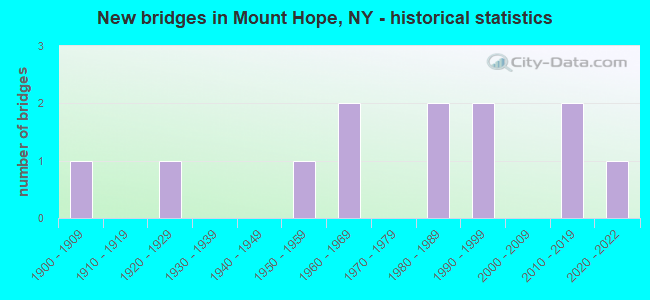
- New bridges - historical statistics
- 11900-1909
- 11920-1929
- 11950-1959
- 21960-1969
- 21980-1989
- 21990-1999
- 22010-2019
- 12020-2022
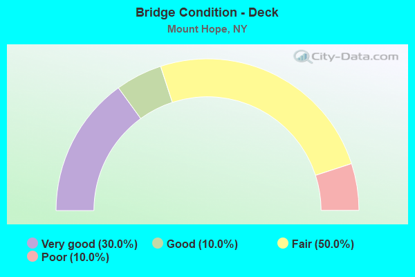
- Bridge Condition - Deck
- 30.0%Very good
- 10.0%Good
- 50.0%Fair
- 10.0%Poor

- Bridge Condition - Superstructure
- 10.0%Excellent
- 20.0%Very good
- 20.0%Good
- 10.0%Satisfactory
- 30.0%Fair
- 10.0%Poor
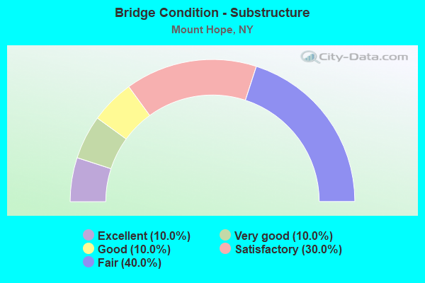
- Bridge Condition - Substructure
- 10.0%Excellent
- 10.0%Very good
- 10.0%Good
- 30.0%Satisfactory
- 40.0%Fair
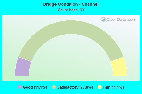
- Bridge Condition - Channel
- 11.1%Good
- 77.8%Satisfactory
- 11.1%Fair
Find on map >> Show street view
Structure Number: 222327, Location: 1.9 MILES NE OF HUGOENOT (Lat: 41.426717, Lng: -74.596814), Route carried "on" structure: Other road , Year Built: 1999, Status: Open, Structure Length: 1.98m (6.50ft), Average Daily Traffic: 456 (year 2018), Truck Traffic: 8%, Average Future Daily Traffic: 638 (year 2038), Design Load: HS 25 or greater, Features Intersected: MNRR PJ LINE, Facility Carried by Structure: GUYMARD TURNPIKE
Minimum Vertical Clearance: 30+ m (98+ ft), Kilometerpoint: 3.218, Lanes on structure: 2, Owner: Railroad, Maintenance Responsibility: Town or Township Highway Agency, Approaching Roadway Width: 9.8m (32.2ft), Skew: 1 degrees, Material/Design: Prestressed concrete, Design/Construction: Box Beam or Girders - Multiple, Number Of Spans In Main Unit: 1, Length of Maximum Span: 18.5m (60.7ft), Curb-To-Curb Width: 9.8m (32.2ft), Out-to-Out Width: 12.5m (41.0ft)
Condition: Deck: Very good, Superstructure: Very good, Substructure: Good, Operating Rating: 98.0 metric tons, Method Used To Determine Operating Rating: Load Factor (LF), Inventory Rating: 40.8 metric tons, Method Used To Determine Inventory Rating: Load Factor (LF), Structural Evaluation: Better than present minimum criteria, Deck Geometry: Equal to present minimum criteria, Underclear: Better than present minimum criteria, Approach Roadway Alignment: Meets minimum limits, Length Of Structure Improvement: 1.98m (6.50ft), Designated Inspection Frequency: Every 24 months, Inspection Date: July 2021, Bridge Improvement Cost: $1,610,000, Roadway Improvement Cost: $943,000, Total Project Cost: $2,553,000 ( Estimate for 2021), Deck Structure Type: Concrete Cast-file-Place, Wearing Surface/Protective System: Wearing Surface: Integral Concrete, Deck Protection: Epoxy Coated Reinforcing
Find on map >> Show street view
Structure Number: 226212, Location: 1.5 MI NW OF HOWELLS (Lat: 41.497639, Lng: -74.479733), Route carried "on" structure: Other road , Year Built: 1927, Year Reconstructed: 1997, Status: Open, Structure Length: 1.46m (4.79ft), Average Daily Traffic: 368 (year 2018), Truck Traffic: 13%, Average Future Daily Traffic: 515 (year 2038), Design Load: HS 25 or greater, Features Intersected: SHAWANGUNK KILL, Facility Carried by Structure: SPRUCE ROAD
Minimum Vertical Clearance: 30+ m (98+ ft), Kilometerpoint: 0.370, Lanes on structure: 2, Owner: Town or Township Highway Agency, Approaching Roadway Width: 7.0m (23.0ft), Material/Design: Steel, Design/Construction: Stringer/Multi-beam, Number Of Spans In Main Unit: 1, Length of Maximum Span: 14.3m (46.9ft), Curb-To-Curb Width: 6.8m (22.3ft), Out-to-Out Width: 7.0m (23.0ft)
Condition: Deck: Fair, Superstructure: Fair, Substructure: Satisfactory, Channel: Satisfactory, Operating Rating: 89.8 metric tons, Method Used To Determine Operating Rating: Load Factor (LF), Inventory Rating: 68.0 metric tons, Method Used To Determine Inventory Rating: Load Factor (LF), Structural Evaluation: Somewhat better than minimum adequacy, Deck Geometry: Meets minimum limits, Waterway Adequacy: Meets minimum limits, Approach Roadway Alignment: Equal to present minimum criteria, Length Of Structure Improvement: 1.46m (4.79ft), Designated Inspection Frequency: Every 24 months, Inspection Date: April 2020, Bridge Improvement Cost: $528,000, Roadway Improvement Cost: $309,000, Total Project Cost: $837,000 ( Estimate for 2021), Deck Structure Type: Corrugated Steel, Wearing Surface/Protective System: Wearing Surface: Bituminous
Find on map >> Show street view
Structure Number: 33449, Location: .9 MILE NW OF HOWELLS (Lat: 41.488744, Lng: -74.479008), Route carried "on" structure: County highway , Year Built: 1969, Year Reconstructed: 2001, Status: Open, Structure Length: 6.04m (19.82ft), Average Daily Traffic: 1,365 (year 2020), Truck Traffic: 6%, Average Future Daily Traffic: 1,688 (year 2040), Design Load: HS 20, Features Intersected: Metro North Railroad Por, Facility Carried by Structure: NEW VERNON ROAD
Minimum Vertical Clearance: 30+ m (98+ ft), Kilometerpoint: 2.043, Lanes on structure: 2, Owner: County Highway Agency, Approaching Roadway Width: 11.9m (39.0ft), Skew: 4 degrees, Material/Design: Steel, Design/Construction: Stringer/Multi-beam, Number Of Spans In Main Unit: 3, Length of Maximum Span: 22.8m (74.8ft), Curb-To-Curb Width: 11.9m (39.0ft), Out-to-Out Width: 12.8m (42.0ft)
Condition: Deck: Fair, Superstructure: Poor, Substructure: Fair, Operating Rating: 62.6 metric tons, Method Used To Determine Operating Rating: Load Factor (LF), Inventory Rating: 35.4 metric tons, Method Used To Determine Inventory Rating: Load Factor (LF), Structural Evaluation: Meets minimum limits, Deck Geometry: Equal to present minimum criteria, Underclear: Equal to present minimum criteria, Approach Roadway Alignment: Better than present minimum criteria, Length Of Structure Improvement: 6.03m (19.78ft), Designated Inspection Frequency: Every 24 months, Inspection Date: August 2021, Bridge Improvement Cost: $3,141,000, Roadway Improvement Cost: $1,840,000, Total Project Cost: $4,981,000 ( Estimate for 2021), Deck Structure Type: Concrete Cast-file-Place, Wearing Surface/Protective System: Wearing Surface: Integral Concrete
Find on map >> Show street view
Structure Number: 334492, Location: 1.6 MILES SE OF OTISVILLE (Lat: 41.450006, Lng: -74.526989), Route carried "on" structure: County highway , Year Built: 2019, Status: Open, Structure Length: 1.52m (4.99ft), Average Daily Traffic: 2,869 (year 2020), Truck Traffic: 5%, Average Future Daily Traffic: 3,549 (year 2040), Features Intersected: SHAWANGUNK KILL, Facility Carried by Structure: MOUNT HOPE ROAD
Minimum Vertical Clearance: 30+ m (98+ ft), Kilometerpoint: 3.089, Lanes on structure: 2, Owner: County Highway Agency, Approaching Roadway Width: 9.1m (29.9ft), Material/Design: Steel, Design/Construction: Stringer/Multi-beam, Number Of Spans In Main Unit: 1, Length of Maximum Span: 14.9m (48.9ft), Curb-To-Curb Width: 9.1m (29.9ft), Out-to-Out Width: 11.8m (38.7ft)
Condition: Deck: Very good, Superstructure: Excellent, Substructure: Excellent, Channel: Satisfactory, Operating Rating: 37.2 metric tons, Method Used To Determine Operating Rating: Load Factor (LF), Inventory Rating: 21.8 metric tons, Method Used To Determine Inventory Rating: Load Factor (LF), Structural Evaluation: Somewhat better than minimum adequacy, Deck Geometry: Meets minimum limits, Waterway Adequacy: Meets minimum limits, Approach Roadway Alignment: Equal to present desirable criteria, Length Of Structure Improvement: 1.52m (4.99ft), Designated Inspection Frequency: Every 24 months, Inspection Date: May 2020, Bridge Improvement Cost: $714,000, Roadway Improvement Cost: $418,000, Total Project Cost: $1,132,000 ( Estimate for 2021), Deck Structure Type: Concrete Precast Panels, Wearing Surface/Protective System: Wearing Surface: Integral Concrete
Find on map >> Show street view
Structure Number: 334493, Location: 1.5 MILES NW OF HOWELLS (Lat: 41.496114, Lng: -74.482925), Route carried "on" structure: County highway , Year Built: 1985, Status: Open, Structure Length: 1.37m (4.49ft), Average Daily Traffic: 1,155 (year 2020), Truck Traffic: 6%, Average Future Daily Traffic: 1,429 (year 2040), Features Intersected: SHAWANGUNK KILL, Facility Carried by Structure: NEW VERNON ROAD
Minimum Vertical Clearance: 30+ m (98+ ft), Kilometerpoint: 3.073, Lanes on structure: 2, Owner: County Highway Agency, Approaching Roadway Width: 9.8m (32.2ft), Material/Design: Steel, Design/Construction: Stringer/Multi-beam, Number Of Spans In Main Unit: 1, Length of Maximum Span: 12.4m (40.7ft), Curb-To-Curb Width: 10.3m (33.8ft), Out-to-Out Width: 11.6m (38.1ft)
Condition: Deck: Poor, Superstructure: Fair, Substructure: Fair, Channel: Satisfactory, Operating Rating: 38.9 metric tons, Method Used To Determine Operating Rating: Load and Resistance Factor Rating (LRFR) rating reported by rating factor(RF) method using HL-93 loadings, Inventory Rating: 30.1 metric tons, Method Used To Determine Inventory Rating: Load and Resistance Factor Rating (LRFR) rating reported by rating factor(RF) method using HL-93 loadings, Structural Evaluation: Somewhat better than minimum adequacy, Deck Geometry: Somewhat better than minimum adequacy, Waterway Adequacy: Equal to present desirable criteria, Approach Roadway Alignment: Equal to present desirable criteria, Length Of Structure Improvement: 1.37m (4.49ft), Designated Inspection Frequency: Every 24 months, Inspection Date: April 2020, Bridge Improvement Cost: $1,030,000, Roadway Improvement Cost: $603,000, Total Project Cost: $1,633,000 ( Estimate for 2021), Deck Structure Type: Concrete Cast-file-Place, Wearing Surface/Protective System: Wearing Surface: Bituminous
Find on map >> Show street view
Structure Number: 334496, Location: 2.1 MI S OF OTISVILLE (Lat: 41.441283, Lng: -74.529900), Route carried "on" structure: County highway , Year Built: 1994, Status: Open, Structure Length: 1.40m (4.59ft), Average Daily Traffic: 302 (year 2020), Truck Traffic: 2%, Average Future Daily Traffic: 423 (year 2040), Design Load: HS 25 or greater, Features Intersected: SHAWANGUNK KILL, Facility Carried by Structure: GUYMARD TURNPIKE
Minimum Vertical Clearance: 30+ m (98+ ft), Kilometerpoint: 0.161, Lanes on structure: 2, Owner: County Highway Agency, Approaching Roadway Width: 9.1m (29.9ft), Skew: 3 degrees, Material/Design: Prestressed concrete, Design/Construction: Box Beam or Girders - Multiple, Number Of Spans In Main Unit: 1, Length of Maximum Span: 12.8m (42.0ft), Curb-To-Curb Width: 10.4m (34.1ft), Out-to-Out Width: 11.1m (36.4ft)
Condition: Deck: Fair, Superstructure: Fair, Substructure: Fair, Channel: Good, Operating Rating: 89.7 metric tons, Method Used To Determine Operating Rating: Load and Resistance Factor Rating (LRFR) rating reported by rating factor(RF) method using HL-93 loadings, Inventory Rating: 69.3 metric tons, Method Used To Determine Inventory Rating: Load and Resistance Factor Rating (LRFR) rating reported by rating factor(RF) method using HL-93 loadings, Structural Evaluation: Somewhat better than minimum adequacy, Deck Geometry: Better than present minimum criteria, Waterway Adequacy: Somewhat better than minimum adequacy, Approach Roadway Alignment: Equal to present desirable criteria, Length Of Structure Improvement: 1.40m (4.59ft), Designated Inspection Frequency: Every 24 months, Inspection Date: July 2021, Bridge Improvement Cost: $670,000, Roadway Improvement Cost: $392,000, Total Project Cost: $1,062,000 ( Estimate for 2021), Wearing Surface/Protective System: Wearing Surface: Bituminous
Find on map >> Show street view
Structure Number: 334497, Location: 1.5 MILES WEST OF HOWELLS (Lat: 41.479956, Lng: -74.495644), Route carried "on" structure: Other road , Year Built: 2020, Status: Open, Structure Length: 1.31m (4.30ft), Average Daily Traffic: 279 (year 2020), Truck Traffic: 1%, Average Future Daily Traffic: 391 (year 2040), Design Load: HS 25 or greater, Features Intersected: SHAWANGUNK KILL, Facility Carried by Structure: CARBOY ROAD
Minimum Vertical Clearance: 30+ m (98+ ft), Kilometerpoint: 1.110, Lanes on structure: 2, Owner: County Highway Agency, Approaching Roadway Width: 5.8m (19.0ft), Material/Design: Concrete, Design/Construction: Frame, Number Of Spans In Main Unit: 1, Length of Maximum Span: 12.2m (40.0ft), Curb-To-Curb Width: 7.9m (25.9ft), Out-to-Out Width: 8.9m (29.2ft)
Condition: Deck: Very good, Superstructure: Very good, Substructure: Very good, Channel: Satisfactory, Operating Rating: 59.0 metric tons, Method Used To Determine Operating Rating: Load and Resistance Factor Rating (LRFR) rating reported by rating factor(RF) method using HL-93 loadings, Inventory Rating: 39.2 metric tons, Method Used To Determine Inventory Rating: Load and Resistance Factor Rating (LRFR) rating reported by rating factor(RF) method using HL-93 loadings, Structural Evaluation: Equal to present desirable criteria, Deck Geometry: Somewhat better than minimum adequacy, Waterway Adequacy: Meets minimum limits, Approach Roadway Alignment: Somewhat better than minimum adequacy, Length Of Structure Improvement: 1.31m (4.30ft), Designated Inspection Frequency: Every 24 months, Inspection Date: December 2020, Bridge Improvement Cost: $606,000, Roadway Improvement Cost: $355,000, Total Project Cost: $961,000 ( Estimate for 2021), Deck Structure Type: Concrete Cast-file-Place, Wearing Surface/Protective System: Wearing Surface: Bituminous, Deck Protection: Epoxy Coated Reinforcing
Find on map >> Show street view
Structure Number: 334498, Location: 3.6 MILES SW OF OTISVILLE (Lat: 41.422017, Lng: -74.560808), Route carried "on" structure: Other road , Year Built: 1959, Status: Open, Structure Length: 0.91m (2.99ft), Average Daily Traffic: 337 (year 2020), Truck Traffic: 4%, Average Future Daily Traffic: 416 (year 2040), Design Load: H 20, Features Intersected: SHAWANGUNK KILL, Facility Carried by Structure: KOHLER ROAD
Minimum Vertical Clearance: 30+ m (98+ ft), Kilometerpoint: 2.237, Lanes on structure: 2, Owner: County Highway Agency, Approaching Roadway Width: 6.4m (21.0ft), Material/Design: Steel, Design/Construction: Stringer/Multi-beam, Number Of Spans In Main Unit: 1, Length of Maximum Span: 8.5m (27.9ft), Curb-To-Curb Width: 8.5m (27.9ft), Out-to-Out Width: 9.5m (31.2ft)
Condition: Deck: Fair, Superstructure: Satisfactory, Substructure: Satisfactory, Channel: Satisfactory, Operating Rating: 52.6 metric tons, Method Used To Determine Operating Rating: Load Factor (LF), Inventory Rating: 31.8 metric tons, Method Used To Determine Inventory Rating: Load Factor (LF), Structural Evaluation: Equal to present minimum criteria, Deck Geometry: Equal to present minimum criteria, Waterway Adequacy: Somewhat better than minimum adequacy, Approach Roadway Alignment: Better than present minimum criteria, Length Of Structure Improvement: 0.91m (2.99ft), Designated Inspection Frequency: Every 24 months, Inspection Date: June 2020, Bridge Improvement Cost: $677,000, Roadway Improvement Cost: $396,000, Total Project Cost: $1,073,000 ( Estimate for 2021), Deck Structure Type: Concrete Cast-file-Place, Wearing Surface/Protective System: Wearing Surface: Bituminous
Find on map >> Show street view
Structure Number: 334499, Location: 3.9 MI SW BLOOMINGBURGH (Lat: 41.500956, Lng: -74.459381), Route carried "on" structure: Other road , Year Built: 1965, Status: Open, Structure Length: 1.16m (3.81ft), Average Daily Traffic: 708 (year 2020), Truck Traffic: 5%, Average Future Daily Traffic: 991 (year 2040), Design Load: H 20, Features Intersected: LITTLE SHAWANGUNK KILL, Facility Carried by Structure: PINE GROVE ROAD
Minimum Vertical Clearance: 30+ m (98+ ft), Kilometerpoint: 4.039, Lanes on structure: 2, Owner: County Highway Agency, Approaching Roadway Width: 6.4m (21.0ft), Material/Design: Steel, Design/Construction: Stringer/Multi-beam, Number Of Spans In Main Unit: 1, Length of Maximum Span: 10.9m (35.8ft), Curb-To-Curb Width: 8.5m (27.9ft), Out-to-Out Width: 9.4m (30.8ft)
Condition: Deck: Fair, Superstructure: Good, Substructure: Satisfactory, Channel: Satisfactory, Operating Rating: 59.6 metric tons, Method Used To Determine Operating Rating: Load and Resistance Factor Rating (LRFR) rating reported by rating factor(RF) method using HL-93 loadings, Inventory Rating: 46.0 metric tons, Method Used To Determine Inventory Rating: Load and Resistance Factor Rating (LRFR) rating reported by rating factor(RF) method using HL-93 loadings, Structural Evaluation: Equal to present minimum criteria, Deck Geometry: Somewhat better than minimum adequacy, Waterway Adequacy: Somewhat better than minimum adequacy, Approach Roadway Alignment: Somewhat better than minimum adequacy, Length Of Structure Improvement: 1.15m (3.77ft), Designated Inspection Frequency: Every 24 months, Inspection Date: June 2020, Bridge Improvement Cost: $929,000, Roadway Improvement Cost: $544,000, Total Project Cost: $1,473,000 ( Estimate for 2021), Deck Structure Type: Concrete Cast-file-Place, Wearing Surface/Protective System: Wearing Surface: Bituminous
Find on map >> Show street view
Structure Number: 336752, Location: 0.6 MI W CR18 (Lat: 41.486589, Lng: -74.489258), Route carried "on" structure: Other road , Year Built: 1982, Status: Open, Structure Length: 1.49m (4.89ft), Average Daily Traffic: 708 (year 2020), Truck Traffic: 5%, Average Future Daily Traffic: 991 (year 2040), Design Load: HS 20, Features Intersected: SHAWANGUNK KILL, Facility Carried by Structure: SHODDY HOLLOW RD
Minimum Vertical Clearance: 30+ m (98+ ft), Kilometerpoint: 4.103, Lanes on structure: 2, Owner: County Highway Agency, Approaching Roadway Width: 8.8m (28.9ft), Skew: 1 degrees, Material/Design: Steel, Design/Construction: Stringer/Multi-beam, Number Of Spans In Main Unit: 1, Length of Maximum Span: 12.8m (42.0ft), Curb-To-Curb Width: 9.0m (29.5ft), Out-to-Out Width: 9.4m (30.8ft)
Condition: Deck: Good, Superstructure: Good, Substructure: Fair, Channel: Fair, Operating Rating: 47.6 metric tons, Method Used To Determine Operating Rating: Load and Resistance Factor Rating (LRFR) rating reported by rating factor(RF) method using HL-93 loadings, Inventory Rating: 36.6 metric tons, Method Used To Determine Inventory Rating: Load and Resistance Factor Rating (LRFR) rating reported by rating factor(RF) method using HL-93 loadings, Structural Evaluation: Somewhat better than minimum adequacy, Deck Geometry: Somewhat better than minimum adequacy, Waterway Adequacy: Equal to present desirable criteria, Approach Roadway Alignment: Equal to present desirable criteria, Length Of Structure Improvement: 1.49m (4.89ft), Designated Inspection Frequency: Every 24 months, Inspection Date: April 2020, Bridge Improvement Cost: $853,000, Roadway Improvement Cost: $499,000, Total Project Cost: $1,352,000 ( Estimate for 2021), Deck Structure Type: Concrete Cast-file-Place, Wearing Surface/Protective System: Wearing Surface: Bituminous
Find on map >> Show street view
Structure Number: 337122, Location: 0.8MI SE Jct Ledge Rd+NV (Lat: 41.482253, Lng: -74.470139), Route carried "on" structure: County highway , Year Built: 2015, Status: Open, Structure Length: 0.64m (2.10ft), Average Daily Traffic: 1,365 (year 2020), Truck Traffic: 6%, Average Future Daily Traffic: 1,688 (year 2040), Design Load: HL 93, Features Intersected: Little Shawangunk Kill, Facility Carried by Structure: New Vernon Road
Minimum Vertical Clearance: 30+ m (98+ ft), Kilometerpoint: 1.014, Lanes on structure: 2, Owner: County Highway Agency, Approaching Roadway Width: 9.1m (29.9ft), Skew: 2 degrees, Material/Design: Concrete, Design/Construction: Culvert, Number Of Spans In Main Unit: 1, Length of Maximum Span: 5.8m (19.0ft), Curb-To-Curb Width: 10.3m (33.8ft), Out-to-Out Width: 11.4m (37.4ft)
Condition: Channel: Satisfactory, Culverts: Good, Operating Rating: 78.0 metric tons, Method Used To Determine Operating Rating: Load Factor (LF), Inventory Rating: 46.3 metric tons, Method Used To Determine Inventory Rating: Load Factor (LF), Structural Evaluation: Better than present minimum criteria, Deck Geometry: Somewhat better than minimum adequacy, Waterway Adequacy: Somewhat better than minimum adequacy, Approach Roadway Alignment: Equal to present desirable criteria, Length Of Structure Improvement: 0.64m (2.10ft), Designated Inspection Frequency: Every 24 months, Inspection Date: October 2021, Bridge Improvement Cost: $206,000, Roadway Improvement Cost: $120,000, Total Project Cost: $326,000 ( Estimate for 2021)
Find on map >> Show street view
Structure Number: 704092, Location: .6 MILE EAST OF OTISVILLE (Lat: 41.471586, Lng: -74.528086), Route carried "under" structure: State highway 211, Year Built: 1900, Structure Length: 0. m, Average Daily Traffic: 5,558 (year 2002), Features Intersected: RTE 211, Facility Carried by Structure: MNRR PJ LINE
Minimum Vertical Clearance: 3.86m (12.66ft), Kilometerpoint: 6.854, Lanes under structure: 2, Material/Design: Steel, Design/Construction: Stringer/Multi-beam, Length of Maximum Span: 8.2m (26.9ft)