Bridge Statistics for Mount Kisco, New York (NY)
Condition, Traffic, Stress, Structural Evaluation, Project Costs
- National Bridge Inventory (NBI) Statistics
- 15Number of bridges
- 92ft / 28.2mTotal length
- $43,003,000Total costs
- 234,195Total average daily traffic
- 3,279Total average daily truck traffic
- National Bridge Inventory (NBI) Registered Bridges for Mount Kisco
- No street view available for this location
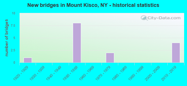
- New bridges - historical statistics
- 11920-1929
- 81950-1959
- 21970-1979
- 42010-2019
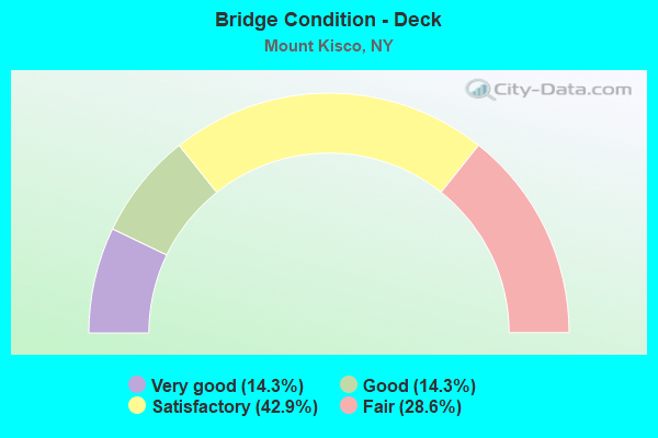
- Bridge Condition - Deck
- 14.3%Very good
- 14.3%Good
- 42.9%Satisfactory
- 28.6%Fair
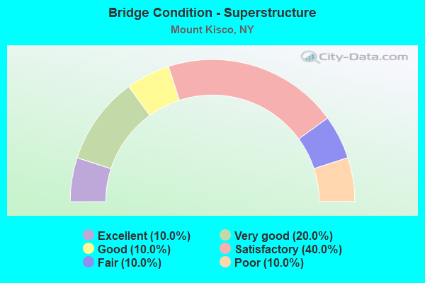
- Bridge Condition - Superstructure
- 10.0%Excellent
- 20.0%Very good
- 10.0%Good
- 40.0%Satisfactory
- 10.0%Fair
- 10.0%Poor
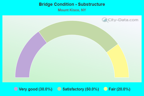
- Bridge Condition - Substructure
- 30.0%Very good
- 50.0%Satisfactory
- 20.0%Fair
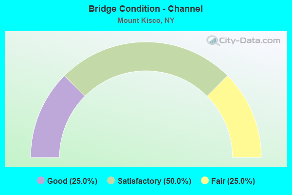
- Bridge Condition - Channel
- 25.0%Good
- 50.0%Satisfactory
- 25.0%Fair
Find on map >> Show street view
Structure Number: 103719, Location: 0.5 MI S JCT RTS 117+172 (Lat: 41.190444, Lng: -73.729978), Route carried "on" structure: State highway 117, Year Built: 1957, Status: Open, Structure Length: 0.82m (2.69ft), Average Daily Traffic: 12,044 (year 2016), Truck Traffic: 3%, Average Future Daily Traffic: 12,100 (year 2040), Design Load: H 20, Features Intersected: KISCO RIVER
Minimum Vertical Clearance: 30+ m (98+ ft), Kilometerpoint: 15.591, Lanes on structure: 2, Base Highway Network: Yes, Owner: State Highway Agency, Approaching Roadway Width: 9.8m (32.2ft), Skew: 3 degrees, Material/Design: Concrete continuous, Design/Construction: Culvert, Number Of Spans In Main Unit: 2, Length of Maximum Span: 3.7m (12.1ft), Curb or Sidewalk Widths: Left: 0.0m, Right: 1.2m (3.9ft)
Condition: Channel: Fair, Culverts: Satisfactory, Operating Rating: 16.8 metric tons, Method Used To Determine Operating Rating: Load and Resistance Factor Rating (LRFR) rating reported by rating factor(RF) method using HL-93 loadings, Inventory Rating: 13.0 metric tons, Method Used To Determine Inventory Rating: Load and Resistance Factor Rating (LRFR) rating reported by rating factor(RF) method using HL-93 loadings, Structural Evaluation: High priority of corrective action, Waterway Adequacy: Superior to present desirable criteria, Approach Roadway Alignment: Equal to present desirable criteria, Length Of Structure Improvement: 0.82m (2.69ft), Designated Inspection Frequency: Every 24 months, Inspection Date: October 2020, Bridge Improvement Cost: $226,000, Roadway Improvement Cost: $132,000, Total Project Cost: $358,000 ( Estimate for 2021)
Find on map >> Show street view
Structure Number: 103776, Location: 0.2 MI W JCT RTS 133+117 (Lat: 41.209319, Lng: -73.729264), Route carried "on" structure: State highway 133, Year Built: 1955, Status: Open, Structure Length: 1.80m (5.91ft), Average Daily Traffic: 13,538 (year 2018), Truck Traffic: 3%, Average Future Daily Traffic: 16,445 (year 2040), Design Load: H 20, Features Intersected: MNRR HA LINE
Minimum Vertical Clearance: 30+ m (98+ ft), Kilometerpoint: 13.596, Lanes on structure: 3, Base Highway Network: Yes, Owner: State Highway Agency, Approaching Roadway Width: 13.4m (44.0ft), Material/Design: Steel, Design/Construction: Stringer/Multi-beam, Number Of Spans In Main Unit: 1, Length of Maximum Span: 17.0m (55.8ft), Curb or Sidewalk Widths: Left: 2.1m (6.9ft), Right: 2.1m (6.9ft), Curb-To-Curb Width: 13.4m (44.0ft), Out-to-Out Width: 18.3m (60.0ft)
Condition: Deck: Satisfactory, Superstructure: Good, Substructure: Satisfactory, Operating Rating: 57.2 metric tons, Method Used To Determine Operating Rating: Load Factor (LF), Inventory Rating: 34.5 metric tons, Method Used To Determine Inventory Rating: Load Factor (LF), Structural Evaluation: Equal to present minimum criteria, Deck Geometry: Somewhat better than minimum adequacy, Underclear: Meets minimum limits, Approach Roadway Alignment: Equal to present desirable criteria, Length Of Structure Improvement: 1.79m (5.87ft), Designated Inspection Frequency: Every 24 months, Inspection Date: September 2020, Bridge Improvement Cost: $3,434,000, Roadway Improvement Cost: $2,011,000, Total Project Cost: $5,444,000 ( Estimate for 2021), Deck Structure Type: Concrete Cast-file-Place, Wearing Surface/Protective System: Wearing Surface: Bituminous
Find on map >> Show street view
Structure Number: 105306, Location: 3.9 MI N EXIT 3 OF I684 (Lat: 41.189169, Lng: -73.687881), Route carried "on" structure: Other road , Year Built: 1971, Year Reconstructed: 2001, Status: Open, Structure Length: 7.41m (24.31ft), Average Daily Traffic: 529 (year 2017), Truck Traffic: 4%, Average Future Daily Traffic: 741 (year 2037), Design Load: HS 20, Features Intersected: 684I684I87011124, RTE I6, Facility Carried by Structure: CHESTNUT RIDGE RD
Minimum Vertical Clearance: 30+ m (98+ ft), Kilometerpoint: 0.998, Lanes on structure: 2, Lanes under structure: 6, Owner: State Highway Agency, Approaching Roadway Width: 7.0m (23.0ft), Skew: 3 degrees, Material/Design: Steel, Design/Construction: Stringer/Multi-beam, Number Of Spans In Main Unit: 2, Length of Maximum Span: 36.0m (118.1ft), Curb-To-Curb Width: 9.5m (31.2ft), Out-to-Out Width: 10.5m (34.4ft)
Condition: Deck: Fair, Superstructure: Satisfactory, Substructure: Satisfactory, Operating Rating: 97.8 metric tons, Method Used To Determine Operating Rating: Field evaluation and documented engineering judgment, Inventory Rating: 32.7 metric tons, Method Used To Determine Inventory Rating: Field evaluation and documented engineering judgment, Structural Evaluation: Equal to present minimum criteria, Deck Geometry: Equal to present minimum criteria, Underclear: Somewhat better than minimum adequacy, Approach Roadway Alignment: Equal to present desirable criteria, Length Of Structure Improvement: 7.40m (24.28ft), Designated Inspection Frequency: Every 24 months, Inspection Date: September 2020, Bridge Improvement Cost: $3,303,000, Roadway Improvement Cost: $1,934,000, Total Project Cost: $5,237,000 ( Estimate for 2021), Deck Structure Type: Concrete Cast-file-Place, Wearing Surface/Protective System: Wearing Surface: Integral Concrete
Find on map >> Show street view
Structure Number: 107969, Location: 3.5 MI N JCT SMRP AND 117 (Lat: 41.202136, Lng: -73.739661), Route carried "on" structure: State highway 987, Year Built: 2018, Status: Open, Structure Length: 1.19m (3.90ft), Average Daily Traffic: 28,444 (year 2013), Truck Traffic: 2%, Average Future Daily Traffic: 40,125 (year 2040), Design Load: HL 93, Features Intersected: BRANCH BROOK
Minimum Vertical Clearance: 32.69m (107.25ft), Kilometerpoint: 38.519, Lanes on structure: 4, Owner: State Highway Agency, Approaching Roadway Width: 21.9m (71.9ft), Skew: 21 degrees, Material/Design: Concrete, Design/Construction: Frame, Number Of Spans In Main Unit: 1, Length of Maximum Span: 11.6m (38.1ft), Curb-To-Curb Width: 21.9m (71.9ft), Out-to-Out Width: 23.7m (77.8ft)
Condition: Superstructure: Very good, Substructure: Very good, Channel: Satisfactory, Inventory Rating: 67.1 metric tons, Method Used To Determine Inventory Rating: Load Factor (LF), Structural Evaluation: Equal to present desirable criteria, Deck Geometry: Better than present minimum criteria, Waterway Adequacy: Superior to present desirable criteria, Approach Roadway Alignment: Equal to present desirable criteria, Length Of Structure Improvement: 1.18m (3.87ft), Designated Inspection Frequency: Every 24 months, Inspection Date: October 2020, Bridge Improvement Cost: $1,502,000, Roadway Improvement Cost: $880,000, Total Project Cost: $2,382,000 ( Estimate for 2021), Wearing Surface/Protective System: Wearing Surface: Bituminous, Membrane: Other
Find on map >> Show street view
Structure Number: 222503, Location: IN MOUNT KISCO (Lat: 41.205003, Lng: -73.732828), Route carried "on" structure: Other road , Year Built: 1953, Status: Open, Structure Length: 1.92m (6.30ft), Average Daily Traffic: 7,265 (year 2015), Truck Traffic: 1%, Average Future Daily Traffic: 8,988 (year 2040), Design Load: H 20, Features Intersected: MNRR HA LINE, Facility Carried by Structure: LIETO DRIVE
Minimum Vertical Clearance: 30+ m (98+ ft), Kilometerpoint: 0.161, Lanes on structure: 2, Owner: Town or Township Highway Agency, Approaching Roadway Width: 9.1m (29.9ft), Material/Design: Steel, Design/Construction: Stringer/Multi-beam, Number Of Spans In Main Unit: 1, Length of Maximum Span: 18.2m (59.7ft), Curb or Sidewalk Widths: Left: 1.5m (4.9ft), Right: 1.5m (4.9ft), Curb-To-Curb Width: 9.1m (29.9ft), Out-to-Out Width: 12.8m (42.0ft)
Condition: Deck: Satisfactory, Superstructure: Satisfactory, Substructure: Satisfactory, Operating Rating: 58.0 metric tons, Method Used To Determine Operating Rating: Load and Resistance Factor Rating (LRFR) rating reported by rating factor(RF) method using HL-93 loadings, Inventory Rating: 44.4 metric tons, Method Used To Determine Inventory Rating: Load and Resistance Factor Rating (LRFR) rating reported by rating factor(RF) method using HL-93 loadings, Structural Evaluation: Equal to present minimum criteria, Deck Geometry: High priority of corrective action, Underclear: Somewhat better than minimum adequacy, Approach Roadway Alignment: Equal to present minimum criteria, Length Of Structure Improvement: 1.92m (6.30ft), Designated Inspection Frequency: Every 24 months, Inspection Date: September 2021, Bridge Improvement Cost: $2,344,000, Roadway Improvement Cost: $1,372,000, Total Project Cost: $3,716,000 ( Estimate for 2021), Deck Structure Type: Concrete Cast-file-Place, Wearing Surface/Protective System: Wearing Surface: Monolithic Concrete, Membrane: Other
Find on map >> Show street view
Structure Number: 226542, Location: IN MOUNT KISCO (Lat: 41.215539, Lng: -73.724336), Route carried "on" structure: Other road , Year Built: 1953, Status: Open, Structure Length: 5.52m (18.11ft), Average Daily Traffic: 10,086 (year 2016), Truck Traffic: 4%, Average Future Daily Traffic: 14,120 (year 2036), Design Load: H 20, Features Intersected: MNRR HA LINE, Facility Carried by Structure: PRESTON WAY
Minimum Vertical Clearance: 30+ m (98+ ft), Kilometerpoint: 0.322, Lanes on structure: 2, Owner: Town or Township Highway Agency, Approaching Roadway Width: 6.7m (22.0ft), Material/Design: Steel, Design/Construction: Stringer/Multi-beam, Number Of Spans In Main Unit: 3, Length of Maximum Span: 22.6m (74.1ft), Curb or Sidewalk Widths: Left: 1.2m (3.9ft), Right: 0.9m (3.0ft), Curb-To-Curb Width: 6.9m (22.6ft), Out-to-Out Width: 9.8m (32.2ft)
Condition: Deck: Fair, Superstructure: Poor, Substructure: Fair, Operating Rating: 52.2 metric tons, Method Used To Determine Operating Rating: Load and Resistance Factor Rating (LRFR) rating reported by rating factor(RF) method using HL-93 loadings, Inventory Rating: 40.2 metric tons, Method Used To Determine Inventory Rating: Load and Resistance Factor Rating (LRFR) rating reported by rating factor(RF) method using HL-93 loadings, Structural Evaluation: Meets minimum limits, Deck Geometry: High priority of replacement, Underclear: Meets minimum limits, Approach Roadway Alignment: Better than present minimum criteria, Length Of Structure Improvement: 5.51m (18.08ft), Designated Inspection Frequency: Every 24 months, Inspection Date: September 2021, Bridge Improvement Cost: $2,092,000, Roadway Improvement Cost: $1,225,000, Total Project Cost: $3,317,000 ( Estimate for 2021), Deck Structure Type: Concrete Cast-file-Place, Wearing Surface/Protective System: Wearing Surface: Monolithic Concrete, Membrane: Other
Find on map >> Show street view
Structure Number: 334796, Location: AT MOUNT KISCO (Lat: 41.194758, Lng: -73.733003), Route carried "on" structure: County highway , Year Built: 1925, Status: Open, Structure Length: 0.73m (2.40ft), Average Daily Traffic: 9,045 (year 2015), Truck Traffic: 2%, Average Future Daily Traffic: 10,987 (year 2040), Features Intersected: KISCO RIVER, Facility Carried by Structure: LEXINGTON AVENUE
Minimum Vertical Clearance: 30+ m (98+ ft), Kilometerpoint: 0.805, Lanes on structure: 2, Owner: County Highway Agency, Approaching Roadway Width: 9.1m (29.9ft), Material/Design: Concrete, Design/Construction: Slab, Number Of Spans In Main Unit: 1, Length of Maximum Span: 6.7m (22.0ft), Curb or Sidewalk Widths: Left: 2.5m (8.2ft), Right: 2.5m (8.2ft), Curb-To-Curb Width: 9.1m (29.9ft), Out-to-Out Width: 15.2m (49.9ft)
Condition: Deck: Satisfactory, Superstructure: Satisfactory, Substructure: Satisfactory, Channel: Good, Operating Rating: 27.5 metric tons, Method Used To Determine Operating Rating: Load and Resistance Factor Rating (LRFR) rating reported by rating factor(RF) method using HL-93 loadings, Inventory Rating: 21.1 metric tons, Method Used To Determine Inventory Rating: Load and Resistance Factor Rating (LRFR) rating reported by rating factor(RF) method using HL-93 loadings, Structural Evaluation: Somewhat better than minimum adequacy, Deck Geometry: High priority of corrective action, Waterway Adequacy: Meets minimum limits, Approach Roadway Alignment: Equal to present desirable criteria, Length Of Structure Improvement: 0.73m (2.40ft), Designated Inspection Frequency: Every 24 months, Inspection Date: April 2021, Bridge Improvement Cost: $361,000, Roadway Improvement Cost: $211,000, Total Project Cost: $572,000 ( Estimate for 2021), Wearing Surface/Protective System: Wearing Surface: Bituminous
Find on map >> Show street view
Structure Number: 337145, Location: 0.3 MI SE JCT W MAIN/ S M (Lat: 41.203967, Lng: -73.730361), Route carried "on" structure: County highway , Year Built: 2017, Status: Open, Structure Length: 1.19m (3.90ft), Average Daily Traffic: 7,684 (year 2016), Truck Traffic: 3%, Average Future Daily Traffic: 9,334 (year 2040), Design Load: HS 25 or greater, Features Intersected: BRANCH BROOK, Facility Carried by Structure: LEXINGTON AVENUE
Minimum Vertical Clearance: 32.69m (107.25ft), Kilometerpoint: 0.016, Lanes on structure: 2, Owner: County Highway Agency, Approaching Roadway Width: 9.4m (30.8ft), Skew: 2 degrees, Material/Design: Prestressed concrete, Design/Construction: Box Beam or Girders - Multiple, Number Of Spans In Main Unit: 1, Length of Maximum Span: 10.4m (34.1ft), Curb or Sidewalk Widths: Left: 1.8m (5.9ft), Right: 4.2m (13.8ft), Curb-To-Curb Width: 9.5m (31.2ft), Out-to-Out Width: 16.8m (55.1ft)
Condition: Deck: Good, Superstructure: Very good, Substructure: Very good, Channel: Satisfactory, Operating Rating: 79.9 metric tons, Method Used To Determine Operating Rating: Field evaluation and documented engineering judgment, Inventory Rating: 40.8 metric tons, Method Used To Determine Inventory Rating: Field evaluation and documented engineering judgment, Structural Evaluation: Equal to present desirable criteria, Deck Geometry: High priority of corrective action, Waterway Adequacy: High priority of corrective action, Approach Roadway Alignment: Equal to present desirable criteria, Length Of Structure Improvement: 1.18m (3.87ft), Designated Inspection Frequency: Every 24 months, Inspection Date: September 2021, Bridge Improvement Cost: $526,000, Roadway Improvement Cost: $308,000, Total Project Cost: $834,000 ( Estimate for 2021), Wearing Surface/Protective System: Wearing Surface: Bituminous, Membrane: Other
Find on map >> Show street view
Structure Number: 5500949, Location: SMRP JCT.W/SH133,W.MAINST (Lat: 41.208919, Lng: -73.736008), Route carried "on" structure: State highway 987D, Year Built: 1953, Status: Open, Structure Length: 2.13m (6.99ft), Average Daily Traffic: 28,444 (year 2013), Truck Traffic: 2%, Average Future Daily Traffic: 40,125 (year 2040), Features Intersected: RTE 133
Minimum Vertical Clearance: 32.69m (107.25ft), Kilometerpoint: 39.469, Lanes on structure: 4, Lanes under structure: 2, Base Highway Network: Yes, Owner: State Highway Agency, Approaching Roadway Width: 12.8m (42.0ft), Skew: 20 degrees, Material/Design: Concrete, Design/Construction: Frame, Number Of Spans In Main Unit: 1, Length of Maximum Span: 18.5m (60.7ft), Curb or Sidewalk Widths: Left: 0.6m (2.0ft), Right: 1.5m (4.9ft), Curb-To-Curb Width: 13.7m (44.9ft), Out-to-Out Width: 16.5m (54.1ft)
Condition: Superstructure: Fair, Substructure: Fair, Operating Rating: 46.3 metric tons, Method Used To Determine Operating Rating: Load Factor (LF), Inventory Rating: 27.2 metric tons, Method Used To Determine Inventory Rating: Load Factor (LF), Structural Evaluation: Somewhat better than minimum adequacy, Deck Geometry: High priority of replacement, Underclear: High priority of corrective action, Approach Roadway Alignment: Equal to present desirable criteria, Length Of Structure Improvement: 2.13m (6.99ft), Designated Inspection Frequency: Every 24 months, Inspection Date: April 2020, Bridge Improvement Cost: $2,445,000, Roadway Improvement Cost: $1,432,000, Total Project Cost: $3,877,000 ( Estimate for 2021), Deck Structure Type: Concrete Cast-file-Place, Wearing Surface/Protective System: Wearing Surface: Bituminous
Find on map >> Show street view
Structure Number: 550095, Location: IN MOUNT KISCO (Lat: 41.214383, Lng: -73.735961), Route carried "on" structure: Other road , Year Built: 1951, Status: Open, Structure Length: 2.38m (7.81ft), Average Daily Traffic: 1,094 (year 2017), Truck Traffic: 4%, Average Future Daily Traffic: 1,532 (year 2037), Design Load: H 20, Features Intersected: 987D987D87012196 SB, RTE, Facility Carried by Structure: CROTON AVENUE
Minimum Vertical Clearance: 30+ m (98+ ft), Kilometerpoint: 0.579, Lanes on structure: 2, Lanes under structure: 4, Owner: State Highway Agency, Approaching Roadway Width: 9.8m (32.2ft), Skew: 1 degrees, Material/Design: Concrete, Design/Construction: Frame, Number Of Spans In Main Unit: 1, Length of Maximum Span: 22.6m (74.1ft), Curb or Sidewalk Widths: Left: 1.5m (4.9ft), Right: 1.5m (4.9ft), Curb-To-Curb Width: 9.8m (32.2ft), Out-to-Out Width: 13.8m (45.3ft)
Condition: Superstructure: Satisfactory, Substructure: Satisfactory, Operating Rating: 61.8 metric tons, Method Used To Determine Operating Rating: Field evaluation and documented engineering judgment, Inventory Rating: 23.8 metric tons, Method Used To Determine Inventory Rating: Field evaluation and documented engineering judgment, Structural Evaluation: Equal to present minimum criteria, Deck Geometry: Somewhat better than minimum adequacy, Underclear: High priority of corrective action, Approach Roadway Alignment: Equal to present minimum criteria, Length Of Structure Improvement: 2.37m (7.78ft), Designated Inspection Frequency: Every 24 months, Inspection Date: June 2020, Bridge Improvement Cost: $2,467,000, Roadway Improvement Cost: $1,445,000, Total Project Cost: $3,912,000 ( Estimate for 2021), Wearing Surface/Protective System: Wearing Surface: Bituminous
Find on map >> Show street view
Structure Number: 5500969, Location: 1.8 MI W JCT SMRP & SH117 (Lat: 41.220056, Lng: -73.726650), Route carried "on" structure: Other road 987D, Year Built: 2017, Status: Open, Structure Length: 3.14m (10.30ft), Average Daily Traffic: 29,212 (year 2020), Average Future Daily Traffic: 41,209 (year 2040), Features Intersected: KISCO AVENUE
Minimum Vertical Clearance: 30+ m (98+ ft), Kilometerpoint: 41.126, Lanes on structure: 4, Lanes under structure: 2, Base Highway Network: Yes, Owner: State Highway Agency, Approaching Roadway Width: 28.7m (94.2ft), Skew: 20 degrees, Material/Design: Steel, Design/Construction: Stringer/Multi-beam, Number Of Spans In Main Unit: 1, Length of Maximum Span: 30.2m (99.1ft), Curb-To-Curb Width: 28.7m (94.2ft), Out-to-Out Width: 29.6m (97.1ft)
Condition: Deck: Very good, Superstructure: Excellent, Substructure: Very good, Operating Rating: 75.8 metric tons, Method Used To Determine Operating Rating: Load and Resistance Factor Rating (LRFR) rating reported by rating factor(RF) method using HL-93 loadings, Inventory Rating: 58.3 metric tons, Method Used To Determine Inventory Rating: Load and Resistance Factor Rating (LRFR) rating reported by rating factor(RF) method using HL-93 loadings, Structural Evaluation: Equal to present desirable criteria, Deck Geometry: Superior to present desirable criteria, Underclear: Equal to present minimum criteria, Approach Roadway Alignment: Equal to present desirable criteria, Length Of Structure Improvement: 3.13m (10.27ft), Designated Inspection Frequency: Every 24 months, Inspection Date: June 2021, Bridge Improvement Cost: $8,422,000, Roadway Improvement Cost: $4,932,000, Total Project Cost: $13,354,000 ( Estimate for 2021), Deck Structure Type: Concrete Cast-file-Place, Wearing Surface/Protective System: Wearing Surface: Monolithic Concrete, Deck Protection: Epoxy Coated Reinforcing
Find on map >> Show street view
Structure Number: 105306, Location: 3.9 MI N EXIT 3 OF I684 (Lat: 41.189169, Lng: -73.687881), Route carried "under" structure: Interstate 684, Year Built: 1971, Structure Length: 0. m, Average Daily Traffic: 62,545 (year 2002), Features Intersected: 684I684I87011124, RTE I6, Facility Carried by Structure: CHESTNUT RIDGE RD
Minimum Vertical Clearance: 5.49m (18.01ft), Kilometerpoint: 19.662, Lanes on structure: 2, Lanes under structure: 3, Material/Design: Steel, Design/Construction: Stringer/Multi-beam, Length of Maximum Span: 36.0m (118.1ft)
Find on map >> Show street view
Structure Number: 5500949, Location: SMRP JCT.W/SH133,W.MAINST (Lat: 41.208919, Lng: -73.736008), Route carried "under" structure: State highway 133, Year Built: 1953, Structure Length: 0. m, Average Daily Traffic: 9,257 (year 2002), Features Intersected: RTE 133, Facility Carried by Structure: RTE 987D
Minimum Vertical Clearance: 4.78m (15.68ft), Kilometerpoint: 13.097, Lanes on structure: 4, Lanes under structure: 2, Material/Design: Concrete, Design/Construction: Frame, Length of Maximum Span: 18.5m (60.7ft)
Find on map >> Show street view
Structure Number: 550095, Location: IN MOUNT KISCO (Lat: 41.214383, Lng: -73.735961), Route carried "under" structure: City street 987D, Year Built: 1951, Structure Length: 0. m, Average Daily Traffic: 4,320 (year 2021), Features Intersected: 987D987D87012196 SB, RTE, Facility Carried by Structure: CROTON AVENUE
Minimum Vertical Clearance: 5.02m (16.47ft), Kilometerpoint: 40.064, Lanes on structure: 2, Lanes under structure: 2, Material/Design: Concrete, Design/Construction: Frame, Length of Maximum Span: 22.6m (74.1ft)
Find on map >> Show street view
Structure Number: 5500969, Location: 1.8 MI W JCT SMRP & SH117 (Lat: 41.220056, Lng: -73.726650), Route carried "under" structure: Other road , Year Built: 2017, Structure Length: 0. m, Average Daily Traffic: 10,688 (year 2018), Truck Traffic: 4%, Features Intersected: KISCO AVENUE, Facility Carried by Structure: RTE 987D
Minimum Vertical Clearance: 10.90m (35.76ft), Kilometerpoint: 0.000, Lanes on structure: 4, Lanes under structure: 2, Material/Design: Steel, Design/Construction: Stringer/Multi-beam, Length of Maximum Span: 30.2m (99.1ft)