Bridge Statistics for Mount Morris, Michigan (MI)
Condition, Traffic, Stress, Structural Evaluation, Project Costs
- National Bridge Inventory (NBI) Statistics
- 16Number of bridges
- 112ft / 34.0mTotal length
- $182,000Total costs
- 198,694Total average daily traffic
- 13,355Total average daily truck traffic
- National Bridge Inventory (NBI) Registered Bridges for Mount Morris
- No street view available for this location
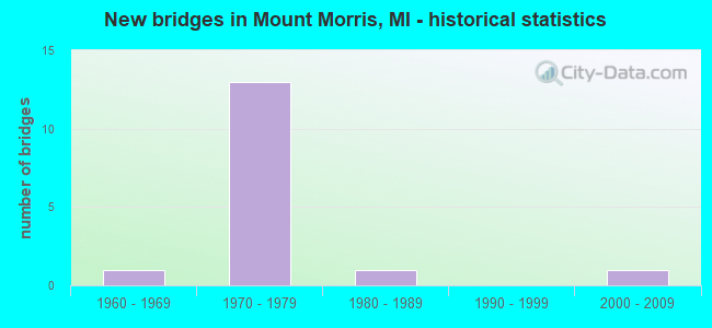
- New bridges - historical statistics
- 11960-1969
- 131970-1979
- 11980-1989
- 12000-2009


- Bridge Condition - Deck
- 42.9%Good
- 42.9%Satisfactory
- 14.3%Fair

- Bridge Condition - Superstructure
- 14.3%Very good
- 42.9%Good
- 42.9%Satisfactory

- Bridge Condition - Substructure
- 28.6%Very good
- 42.9%Good
- 28.6%Satisfactory

- Bridge Condition - Channel
- 25.0%Good
- 50.0%Satisfactory
- 25.0%Poor

- Bridge Condition - Culverts
- 66.7%Satisfactory
- 33.3%Fair
Find on map >> Show street view
Structure Number: 237, Location: APPROX 1/4MI S OF 144TH A (Lat: 42.736503, Lng: -85.751767), Route carried "on" structure: County highway , Year Built: 1971, Status: Open, Structure Length: 0.82m (2.69ft), Average Daily Traffic: 209 (year 2002), Truck Traffic: 7%, Average Future Daily Traffic: 418 (year 2022), Design Load: H 20, Features Intersected: RED RUN DRAIN, Facility Carried by Structure: 21ST STREET
Minimum Vertical Clearance: 30.48m (100.00ft), Kilometerpoint: 4.481, Lanes on structure: 2, Owner: County Highway Agency, Approaching Roadway Width: 6.7m (22.0ft), Skew: 1 degrees, Material/Design: Steel, Design/Construction: Culvert, Number Of Spans In Main Unit: 2, Length of Maximum Span: 3.4m (11.2ft)
Condition: Channel: Satisfactory, Culverts: Fair, Operating Rating: 41.5 metric tons, Method Used To Determine Operating Rating: Load Factor (LF) rating reported by rating factor (RF) method using MS18 loading, Inventory Rating: 24.9 metric tons, Method Used To Determine Inventory Rating: Load Factor (LF) rating reported by rating factor (RF) method using MS18 loading, Structural Evaluation: Somewhat better than minimum adequacy, Waterway Adequacy: Somewhat better than minimum adequacy, Approach Roadway Alignment: Equal to present desirable criteria, Designated Inspection Frequency: Every 24 months, Inspection Date: April 2021
Find on map >> Show street view
Structure Number: 268, Location: LEE TWP SEC 21-22 (Lat: 42.449978, Lng: -86.070689), Route carried "on" structure: County highway , Year Built: 2004, Status: Open, Structure Length: 1.40m (4.59ft), Average Daily Traffic: 140 (year 2020), Truck Traffic: 7%, Average Future Daily Traffic: 208 (year 2040), Design Load: HS 20, Features Intersected: M BR BLACK RIVER, Facility Carried by Structure: 54TH STREET
Minimum Vertical Clearance: 30.48m (100.00ft), Kilometerpoint: 3.471, Lanes on structure: 2, Owner: County Highway Agency, Approaching Roadway Width: 9.1m (29.9ft), Skew: 1 degrees, Material/Design: Prestressed concrete, Design/Construction: Box Beam or Girders - Multiple, Number Of Spans In Main Unit: 1, Length of Maximum Span: 14.0m (45.9ft), Curb-To-Curb Width: 9.1m (29.9ft), Out-to-Out Width: 9.5m (31.2ft)
Condition: Deck: Good, Superstructure: Good, Substructure: Very good, Channel: Good, Operating Rating: 77.4 metric tons, Method Used To Determine Operating Rating: Load Factor (LF) rating reported by rating factor (RF) method using MS18 loading, Inventory Rating: 46.3 metric tons, Method Used To Determine Inventory Rating: Load Factor (LF) rating reported by rating factor (RF) method using MS18 loading, Structural Evaluation: Better than present minimum criteria, Deck Geometry: Equal to present minimum criteria, Waterway Adequacy: Equal to present desirable criteria, Approach Roadway Alignment: Equal to present desirable criteria, Designated Inspection Frequency: Every 24 months, Inspection Date: April 2021, Deck Structure Type: Concrete Precast Panels, Wearing Surface/Protective System: Wearing Surface: Bituminous, Membrane: Preformed Fabric
Find on map >> Show street view
Structure Number: 268, Location: 1 MI N OF FLINT CITY LTS (Lat: 43.090358, Lng: -83.686314), Route carried "on" structure: County highway 2002, Year Built: 1977, Status: Open, Structure Length: 4.42m (14.50ft), Average Daily Traffic: 7,162 (year 1996), Truck Traffic: 4%, Average Future Daily Traffic: 13,000 (year 2016), Design Load: HS 20, Features Intersected: I-475, Facility Carried by Structure: COLDWATER ROAD
Minimum Vertical Clearance: 30.48m (100.00ft), Kilometerpoint: 13.582, Lanes on structure: 4, Lanes under structure: 6, Owner: State Highway Agency, Approaching Roadway Width: 15.8m (51.8ft), Material/Design: Steel, Design/Construction: Stringer/Multi-beam, Number Of Spans In Main Unit: 2, Length of Maximum Span: 22.2m (72.8ft), Curb or Sidewalk Widths: Left: 1.8m (5.9ft), Right: 1.8m (5.9ft), Curb-To-Curb Width: 15.8m (51.8ft), Out-to-Out Width: 20.2m (66.3ft)
Condition: Deck: Satisfactory, Superstructure: Good, Substructure: Good, Operating Rating: 67.1 metric tons, Method Used To Determine Operating Rating: Load Factor (LF), Inventory Rating: 40.3 metric tons, Method Used To Determine Inventory Rating: Load Factor (LF), Structural Evaluation: Better than present minimum criteria, Deck Geometry: Meets minimum limits, Underclear: High priority of corrective action, Approach Roadway Alignment: Equal to present desirable criteria, Length Of Structure Improvement: 4.42m (14.50ft), Designated Inspection Frequency: Every 24 months, Inspection Date: July 2020, Bridge Improvement Cost: $110,000, Roadway Improvement Cost: $6,000, Total Project Cost: $68,000, Deck Structure Type: Concrete Cast-file-Place, Wearing Surface/Protective System: Wearing Surface: Monolithic Concrete
Find on map >> Show street view
Structure Number: 2681, Location: 1.7 MI N / FLINT CITY LTS (Lat: 43.098975, Lng: -83.694239), Route carried "on" structure: Interstate 475, Year Built: 1977, Status: Open, Structure Length: 5.29m (17.36ft), Average Daily Traffic: 31,300 (year 2007), Truck Traffic: 8%, Average Future Daily Traffic: 28,209 (year 2018), Design Load: HS 25 or greater, Features Intersected: SAGINAW STREET
Minimum Vertical Clearance: 30+ m (98+ ft), Kilometerpoint: 21.107, Lanes on structure: 6, Lanes under structure: 6, Base Highway Network: Yes (Inventory Route: 149, Subroute: 3), Owner: State Highway Agency, Approaching Roadway Width: 36.8m (120.7ft), Skew: 31 degrees, Material/Design: Steel, Design/Construction: Stringer/Multi-beam, Number Of Spans In Main Unit: 4, Length of Maximum Span: 17.0m (55.8ft), Curb-To-Curb Width: 34.8m (114.2ft), Out-to-Out Width: 35.3m (115.8ft)
Condition: Deck: Fair, Superstructure: Satisfactory, Substructure: Satisfactory, Operating Rating: 74.8 metric tons, Method Used To Determine Operating Rating: Load Factor (LF) rating reported by rating factor (RF) method using MS18 loading, Inventory Rating: 44.7 metric tons, Method Used To Determine Inventory Rating: Load Factor (LF) rating reported by rating factor (RF) method using MS18 loading, Structural Evaluation: Equal to present minimum criteria, Deck Geometry: Superior to present desirable criteria, Underclear: Meets minimum limits, Approach Roadway Alignment: Equal to present desirable criteria, Length Of Structure Improvement: 5.27m (17.29ft), Designated Inspection Frequency: Every 24 months, Inspection Date: Febuary 2021, Bridge Improvement Cost: $188,000, Roadway Improvement Cost: $10,000, Total Project Cost: $114,000, Deck Structure Type: Concrete Cast-file-Place, Wearing Surface/Protective System: Wearing Surface: Latex Concrete
Find on map >> Show street view
Structure Number: 2682, Location: 1.5 MI E OF N JCT I-75 (Lat: 43.096219, Lng: -83.733747), Route carried "on" structure: Interstate 475, Year Built: 1971, Year Reconstructed: 2010, Status: Open, Structure Length: 5.08m (16.67ft), Average Daily Traffic: 13,300 (year 2007), Truck Traffic: 9%, Average Future Daily Traffic: 12,845 (year 2018), Design Load: HS 20+Mod, Features Intersected: CLIO RD
Minimum Vertical Clearance: 30.48m (100.00ft), Kilometerpoint: 24.592, Lanes on structure: 3, Lanes under structure: 6, Base Highway Network: Yes (Inventory Route: 149, Subroute: 4), Owner: State Highway Agency, Approaching Roadway Width: 18.2m (59.7ft), Skew: 1 degrees, Material/Design: Prestressed concrete, Design/Construction: Stringer/Multi-beam, Number Of Spans In Main Unit: 4, Length of Maximum Span: 16.4m (53.8ft), Curb-To-Curb Width: 20.0m (65.6ft), Out-to-Out Width: 21.0m (68.9ft)
Condition: Deck: Good, Superstructure: Satisfactory, Substructure: Good, Operating Rating: 59.2 metric tons, Method Used To Determine Operating Rating: Load Factor (LF), Inventory Rating: 35.4 metric tons, Method Used To Determine Inventory Rating: Load Factor (LF), Structural Evaluation: Equal to present minimum criteria, Deck Geometry: Superior to present desirable criteria, Underclear: Meets minimum limits, Approach Roadway Alignment: Equal to present desirable criteria, Designated Inspection Frequency: Every 24 months, Inspection Date: Febuary 2021, Deck Structure Type: Concrete Cast-file-Place, Wearing Surface/Protective System: Wearing Surface: Latex Concrete, Membrane: Other, Deck Protection: Epoxy Coated Reinforcing
Find on map >> Show street view
Structure Number: 2686, Location: 3.0 MI E OF N JCT I-75 (Lat: 43.099656, Lng: -83.707908), Route carried "on" structure: Interstate 475, Year Built: 1971, Status: Open, Structure Length: 3.41m (11.19ft), Average Daily Traffic: 23,600 (year 2016), Truck Traffic: 7%, Average Future Daily Traffic: 26,100 (year 2036), Design Load: HS 20+Mod, Features Intersected: DETROIT ST
Minimum Vertical Clearance: 30.48m (100.00ft), Kilometerpoint: 22.226, Lanes on structure: 6, Lanes under structure: 2, Base Highway Network: Yes (Inventory Route: 149, Subroute: 3), Owner: State Highway Agency, Approaching Roadway Width: 28.6m (93.8ft), Skew: 31 degrees, Material/Design: Prestressed concrete, Design/Construction: Stringer/Multi-beam, Number Of Spans In Main Unit: 3, Length of Maximum Span: 13.8m (45.3ft), Curb-To-Curb Width: 29.0m (95.1ft), Out-to-Out Width: 30.4m (99.7ft)
Condition: Deck: Good, Superstructure: Very good, Substructure: Very good, Operating Rating: 50.9 metric tons, Method Used To Determine Operating Rating: Load Factor (LF) rating reported by rating factor (RF) method using MS18 loading, Inventory Rating: 30.5 metric tons, Method Used To Determine Inventory Rating: Load Factor (LF) rating reported by rating factor (RF) method using MS18 loading, Structural Evaluation: Better than present minimum criteria, Deck Geometry: Better than present minimum criteria, Underclear: Meets minimum limits, Approach Roadway Alignment: Equal to present desirable criteria, Designated Inspection Frequency: Every 24 months, Inspection Date: April 2020, Deck Structure Type: Concrete Cast-file-Place, Wearing Surface/Protective System: Wearing Surface: Latex Concrete, Deck Protection: Epoxy Coated Reinforcing
Find on map >> Show street view
Structure Number: 2687, Location: 0.6 MI E OF N JCT I-75 (Lat: 43.096233, Lng: -83.753697), Route carried "on" structure: County highway , Year Built: 1971, Status: Open, Structure Length: 7.04m (23.10ft), Average Daily Traffic: 2,000 (year 1996), Truck Traffic: 3%, Average Future Daily Traffic: 3,600 (year 2016), Design Load: HS 20, Features Intersected: I-475, Facility Carried by Structure: JENNINGS RD
Minimum Vertical Clearance: 30.48m (100.00ft), Kilometerpoint: 5.569, Lanes on structure: 2, Lanes under structure: 4, Owner: State Highway Agency, Approaching Roadway Width: 11.5m (37.7ft), Material/Design: Steel continuous, Design/Construction: Stringer/Multi-beam, Number Of Spans In Main Unit: 2, Length of Maximum Span: 35.3m (115.8ft), Curb or Sidewalk Widths: Left: 0.2m (0.7ft), Right: 0.2m (0.7ft), Curb-To-Curb Width: 11.5m (37.7ft), Out-to-Out Width: 12.3m (40.4ft)
Condition: Deck: Satisfactory, Superstructure: Good, Substructure: Good, Operating Rating: 63.2 metric tons, Method Used To Determine Operating Rating: Load Factor (LF), Inventory Rating: 37.9 metric tons, Method Used To Determine Inventory Rating: Load Factor (LF), Structural Evaluation: Better than present minimum criteria, Deck Geometry: Equal to present minimum criteria, Underclear: High priority of corrective action, Approach Roadway Alignment: Equal to present desirable criteria, Designated Inspection Frequency: Every 24 months, Inspection Date: Febuary 2021, Deck Structure Type: Concrete Cast-file-Place, Wearing Surface/Protective System: Wearing Surface: Latex Concrete
Find on map >> Show street view
Structure Number: 2691, Location: 1.5 MI E OF N JCT I-75 (Lat: 43.096506, Lng: -83.733764), Route carried "on" structure: Interstate 475, Year Built: 1971, Status: Open, Structure Length: 5.08m (16.67ft), Average Daily Traffic: 13,300 (year 2007), Truck Traffic: 9%, Average Future Daily Traffic: 12,845 (year 2018), Design Load: HS 20+Mod, Features Intersected: CLIO RD
Minimum Vertical Clearance: 30.48m (100.00ft), Kilometerpoint: 24.384, Lanes on structure: 3, Lanes under structure: 6, Base Highway Network: Yes (Inventory Route: 149, Subroute: 3), Owner: State Highway Agency, Approaching Roadway Width: 17.3m (56.8ft), Skew: 1 degrees, Material/Design: Prestressed concrete, Design/Construction: Stringer/Multi-beam, Number Of Spans In Main Unit: 4, Length of Maximum Span: 16.4m (53.8ft), Curb-To-Curb Width: 20.0m (65.6ft), Out-to-Out Width: 21.0m (68.9ft)
Condition: Deck: Satisfactory, Superstructure: Satisfactory, Substructure: Satisfactory, Operating Rating: 60.9 metric tons, Method Used To Determine Operating Rating: Load Factor (LF), Inventory Rating: 36.5 metric tons, Method Used To Determine Inventory Rating: Load Factor (LF), Structural Evaluation: Equal to present minimum criteria, Deck Geometry: Superior to present desirable criteria, Underclear: Meets minimum limits, Approach Roadway Alignment: Equal to present desirable criteria, Designated Inspection Frequency: Every 24 months, Inspection Date: Febuary 2021, Deck Structure Type: Concrete Cast-file-Place, Wearing Surface/Protective System: Wearing Surface: Latex Concrete
Find on map >> Show street view
Structure Number: 5049, Location: 350 FT N OF 76TH ST (Lat: 42.826986, Lng: -85.663569), Route carried "on" structure: County highway 2001, Year Built: 1969, Status: Open, Structure Length: 0.73m (2.40ft), Average Daily Traffic: 13,066 (year 2004), Average Future Daily Traffic: 22,210 (year 2024), Design Load: HS 20+Mod, Features Intersected: SHARPS CREEK, Facility Carried by Structure: DIVISION AVE
Minimum Vertical Clearance: 30.48m (100.00ft), Kilometerpoint: 7.442, Lanes on structure: 4, Owner: County Highway Agency, Approaching Roadway Width: 14.0m (45.9ft), Material/Design: Steel, Design/Construction: Culvert, Number Of Spans In Main Unit: 2, Length of Maximum Span: 3.0m (9.8ft), Curb or Sidewalk Widths: Left: 1.5m (4.9ft), Right: 0.0m
Condition: Channel: Satisfactory, Culverts: Satisfactory, Operating Rating: 56.4 metric tons, Method Used To Determine Operating Rating: Load Factor (LF) rating reported by rating factor (RF) method using MS18 loading, Inventory Rating: 50.5 metric tons, Method Used To Determine Inventory Rating: Load Factor (LF) rating reported by rating factor (RF) method using MS18 loading, Structural Evaluation: Equal to present minimum criteria, Waterway Adequacy: Equal to present desirable criteria, Approach Roadway Alignment: Equal to present desirable criteria, Designated Inspection Frequency: Every 24 months, Inspection Date: October 2021
Find on map >> Show street view
Structure Number: 12833, Location: MT. MORRIS TWP. SEC. 13 (Lat: 43.100225, Lng: -83.707939), Route carried "on" structure: County highway , Year Built: 1985, Status: Open, Structure Length: 0.73m (2.40ft), Average Daily Traffic: 3,793 (year 2017), Truck Traffic: 3%, Average Future Daily Traffic: 6,851 (year 2037), Features Intersected: HUGHES DRAIN, Facility Carried by Structure: DETROIT STREET
Minimum Vertical Clearance: 30.48m (100.00ft), Kilometerpoint: 9.318, Lanes on structure: 2, Owner: County Highway Agency, Approaching Roadway Width: 7.9m (25.9ft), Skew: 1 degrees, Material/Design: Concrete, Design/Construction: Culvert, Number Of Spans In Main Unit: 2, Length of Maximum Span: 3.0m (9.8ft), Curb-To-Curb Width: 7.6m (24.9ft), Out-to-Out Width: 8.0m (26.2ft)
Condition: Channel: Poor, Culverts: Satisfactory, Operating Rating: 68.0 metric tons, Method Used To Determine Operating Rating: Load Factor (LF) rating reported by rating factor (RF) method using MS18 loading, Inventory Rating: 40.8 metric tons, Method Used To Determine Inventory Rating: Load Factor (LF) rating reported by rating factor (RF) method using MS18 loading, Structural Evaluation: Equal to present minimum criteria, Deck Geometry: High priority of replacement, Waterway Adequacy: Better than present minimum criteria, Approach Roadway Alignment: Equal to present desirable criteria, Designated Inspection Frequency: Every 24 months, Inspection Date: November 2020
Find on map >> Show street view
Structure Number: 268, Location: 1 MI N OF FLINT CITY LTS (Lat: 43.090358, Lng: -83.686314), Route carried "under" structure: Interstate 475, Year Built: 1977, Structure Length: 0. m, Average Daily Traffic: 31,300 (year 2007), Truck Traffic: 7%, Features Intersected: I-475, Facility Carried by Structure: COLDWATER ROAD
Minimum Vertical Clearance: 4.93m (16.17ft), Kilometerpoint: 19.849, Lanes on structure: 4, Lanes under structure: 6, Material/Design: Steel, Design/Construction: Stringer/Multi-beam, Length of Maximum Span: 22.2m (72.8ft)
Find on map >> Show street view
Structure Number: 2681, Location: 1.7 MI N / FLINT CITY LTS (Lat: 43.098975, Lng: -83.694239), Route carried "under" structure: County highway 2002, Year Built: 1977, Structure Length: 0. m, Average Daily Traffic: 12,862 (year 1995), Truck Traffic: 7%, Features Intersected: SAGINAW STREET, Facility Carried by Structure: I-475
Minimum Vertical Clearance: 4.78m (15.68ft), Kilometerpoint: 27.748, Lanes on structure: 6, Lanes under structure: 6, Material/Design: Steel, Design/Construction: Stringer/Multi-beam, Length of Maximum Span: 17.0m (55.8ft)
Find on map >> Show street view
Structure Number: 2682, Location: 1.5 MI E OF N JCT I-75 (Lat: 43.096219, Lng: -83.733747), Route carried "under" structure: County highway 2002, Year Built: 1971, Structure Length: 0. m, Average Daily Traffic: 9,842 (year 1996), Truck Traffic: 5%, Features Intersected: CLIO RD, Facility Carried by Structure: I-475 SB
Minimum Vertical Clearance: 4.95m (16.24ft), Kilometerpoint: 6.417, Lanes on structure: 3, Lanes under structure: 6, Material/Design: Prestressed concrete, Design/Construction: Stringer/Multi-beam, Length of Maximum Span: 16.4m (53.8ft)
Find on map >> Show street view
Structure Number: 2686, Location: 3.0 MI E OF N JCT I-75 (Lat: 43.099656, Lng: -83.707908), Route carried "under" structure: County highway , Year Built: 1971, Structure Length: 0. m, Average Daily Traffic: 3,000 (year 1996), Truck Traffic: 3%, Features Intersected: DETROIT ST, Facility Carried by Structure: I-475
Minimum Vertical Clearance: 4.32m (14.17ft), Kilometerpoint: 9.272, Lanes on structure: 6, Lanes under structure: 2, Material/Design: Prestressed concrete, Design/Construction: Stringer/Multi-beam, Length of Maximum Span: 13.8m (45.3ft)
Find on map >> Show street view
Structure Number: 2687, Location: 0.6 MI E OF N JCT I-75 (Lat: 43.096233, Lng: -83.753697), Route carried "under" structure: Interstate 475, Year Built: 1971, Structure Length: 0. m, Average Daily Traffic: 23,978 (year 2007), Truck Traffic: 9%, Features Intersected: I-475, Facility Carried by Structure: JENNINGS RD
Minimum Vertical Clearance: 4.55m (14.93ft), Kilometerpoint: 26.010, Lanes on structure: 2, Lanes under structure: 4, Material/Design: Steel continuous, Design/Construction: Stringer/Multi-beam, Length of Maximum Span: 35.3m (115.8ft)
Find on map >> Show street view
Structure Number: 2691, Location: 1.5 MI E OF N JCT I-75 (Lat: 43.096506, Lng: -83.733764), Route carried "under" structure: County highway 2002, Year Built: 1971, Structure Length: 0. m, Average Daily Traffic: 9,842 (year 1996), Truck Traffic: 5%, Features Intersected: CLIO RD, Facility Carried by Structure: I-475 NB
Minimum Vertical Clearance: 4.78m (15.68ft), Kilometerpoint: 6.449, Lanes on structure: 3, Lanes under structure: 6, Material/Design: Prestressed concrete, Design/Construction: Stringer/Multi-beam, Length of Maximum Span: 16.4m (53.8ft)